

Oregon map
Springfield map
About 61,182 people live here (Census Bureau, 2024 estimate). The sheet's index lists 300 streets; Officer Chris Kilcullen Memorial Highway, Main Street and E Street cross the most grid squares. Also on it: Washburne Historic District, Bob Artz Park and Gateway Mall.
Open the map (PDF, US Letter)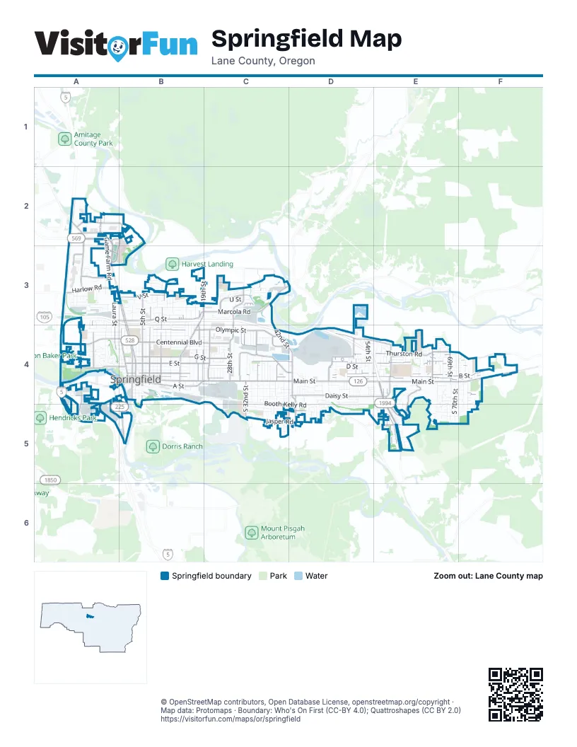
Street index of Springfield
Each street on the sheet and the grid squares it crosses.
- Officer Chris Kilcullen Memorial HighwayA3, B3, C3, B4, C4, D4, E4
- Whilamut Passage BridgeA4
- I-5 North Franklin BoulevardA4, A5
- 42nd Street Connection #2C4
- 42nd Street Connection #3C3, C4
- 42nd Street Connection #1C4
- 42nd Street Connection #4C3, C4
- Pacific Highway West #1W (91) Roadway #2A4, A5
- West Q Street RampA3
- Springfield Highway (Roadway #1)B4
- Main StreetA4, B4, C4, D4, E4, F4
- Bob Straub ParkwayE4, E5
- South A StreetA4, B4, C4
- Marcola RoadB3, C3, D3
- Pioneer Parkway EastA3, B3, B4
- Pioneer Parkway WestA3, B3, B4
- Q StreetB3
- 42nd StreetC3, C4, D4
- Franklin BoulevardA4, B5
- Martin Luther King Jr. ParkwayA2, A3
- Beltline RoadA2
- Game Farm RoadA2, A3
- Randy Papé BeltlineA2
- McKenzie HighwayF4
- South 2nd StreetB4
- Hayden Bridge WayA3, B3
- West Q StreetA3, B3
- Olympic StreetB4, C4
- Centennial BoulevardB4, C4
- 5th StreetB3, B4
- Gateway StreetA2, A3
- 28th StreetC3, C4
- Mohawk BoulevardB3, B4
- Jasper RoadC5, D5
- 18th StreetB3, B4
- South 42nd StreetD4, D5
- Harlow RoadA3
- West Centennial BoulevardA4, B4
- Glenwood BoulevardA4, A5
- 14th StreetB3, B4
- South 14th StreetB4
- North Game Farm RoadA2
- Martin Luther King Junior BoulevardA4
- E StreetB4, C4, D4, E4, F4
- A StreetB4, C4, D4, E4, F4
- B StreetB4, C4, D4, E4, F4
- G StreetB4, C4, D4, E4, F4
- Daisy StreetD4, E4, F4
- Thurston RoadE4, F4
- V StreetB3, C3
- Mountaingate DriveE4, E5
- 10th StreetB3, B4
- International WayA2, B2
- 7th StreetB3, B4
- 31st StreetC3, C4
- 19th StreetB3, B4
- 30th StreetC4
- High Banks RoadD4, E4
- Riverbend DriveA2, B2, A3
- Laura StreetA3, A4
- 35th StreetC3, C4
- Mill StreetB4
- 21st StreetC4
- South 58th StreetE4, E5
- Commercial AvenueC4, D4
- 66th StreetE4
- West D StreetA4, B4
- Aspen StreetA4
- Rainbow DriveA3, A4
- South 57th StreetE4, E5
- South 32nd StreetC4, C5
- South 57th PlaceE4, E5
- Mount Vernon RoadD5, E5
- 58th StreetE4
- 52nd StreetD4
- Industrial AvenueC4
- East 19th AvenueA4, B4
- 69th StreetE4
- Oakdale AvenueA3
- 40th StreetC4
- 48th StreetD4
- Henderson AvenueA4, A5
- Deadmond Ferry RoadA2, B2
- Cardinal WayA3
- Gateway LoopA3
- Yolanda AvenueC3
- Maple Island Farm RoadA2
- East Game Farm RoadA2
- East 17th AvenueA4
- South 5th StreetB4
- Hayden Bridge RoadB3, C3
- St. Joseph PlaceA2, B2
- South Mill StreetB4
- West Game Farm RoadA2
- South 10th StreetB4
- South 7th StreetB4
- D StreetB4, C4, D4, E4, F4
- F StreetB4, D4, E4, F4
- C StreetB4, C4, D4, E4, F4
- Booth Kelly RoadC4, D4, C5, D5
- T StreetB3, C3
- Aster StreetB4, C4, D4, E4, F4
- 8th StreetB3, B4
- J StreetB4, C4, D4, E4
- Weyerhaeuser RoadD4
- 9th StreetB3, B4
- 6th StreetB3, B4
- 16th StreetB3, B4
- Holly StreetD4, D5, E5, F5
- South F StreetB4, C4
- L StreetB4, C4
- S StreetB3
- South 54th StreetD4, E4, D5
- U StreetB3, C3
- M StreetB4, C4
- 17th StreetB3, B4
- I StreetB4, C4, D4
- 12th StreetB3, B4
- 33rd StreetC3, C4
- Camellia StreetC4, D4, E4, F4
- 37th StreetC3, C4
- 32nd StreetC3, C4
- Water StreetA4, B4
- Virginia AvenueC4, D4
- South 70th StreetE4, E5
- West Fairview DriveA4, B4
- Glacier DriveD4, E4, D5, E5, F5
- 54th StreetD4
- Kelly BoulevardA4
- South 71st StreetF4, E5, F5
- 65th StreetE4
- Graystone LoopE4, E5
- South 51st PlaceD4, D5
- South E StreetB4, C4, D4, E4, F4
- Ivy StreetD5, E5
- South 67th StreetE4, E5
- Quinalt StreetB3, B4
- R StreetB3, C3
- South 59th StreetE4, E5
- South 38th StreetC4, C5
- Prescott LaneA3, A4
- South 44th StreetD4, D5
- Pleasant StreetB4
- Forest Ridge DriveE4, E5
- Bluebelle WayC4, D4, E4, F4
- South 47th StreetD4, D5
- H StreetB4, C4
- South 28th StreetC4, C5
- Douglas DriveC5
- Cherokee DriveC4, C5
- South 46th StreetD4, D5
- 71st StreetF4
- Pierce ParkwayC3
- Lochaven AvenueA3
- South 37th StreetC4, C5
- 4th StreetB4
- 1st StreetB4
- South 69th PlaceE4, E5
- Cloverleaf LoopA3
- West N StreetA4, B4
- 56th StreetE4
- South 72nd StreetF4, F5
- Oregon AvenueC4
- 55th StreetD4, E4
- Shelley StreetA3
- N StreetB4
- 57th StreetE4
- West M StreetA4, B4
- 36th StreetC4
- 64th StreetE4
- South 68th PlaceE4, E5
- Lawnridge AvenueB3
- 67th StreetE4
- 72nd StreetF4
- 34th StreetC4
- West Quinalt StreetA3, A4
- 11th StreetB3, B4
- Forsythia DriveC4, D4
- 20th StreetC3, C4
- McKenzie Crest DriveB3
- 23rd StreetC3, C4
- Scotts Glen DriveA3
- Squirrel StreetD5
- Janus StreetA4
- 51st StreetD4
- 39th StreetC4
- Nugget WayA4, A5, B5
- 38th StreetC4
- South 43rd StreetD4, D5
- South B StreetB4
- East 22nd AvenueA5
- 26th StreetC4
- Old Orchard LaneB3
- South 49th PlaceD4, D5
- South 40th StreetC4, C5
- Redwood DriveC5
- Market StreetB3, B4
- South 35th StreetC4
- Hamilton StreetA4
- 53rd PlaceD4
- South 53rd StreetD4
- South 69th StreetE4, E5
- Cedar View DriveD5
- South 41st StreetC4, C5
- Maia LoopC3
- West Olympic StreetA4, B4
- 22nd StreetC3, C4
- 2nd StreetB3
- 15th StreetB3
- W StreetC3
- Fenya StreetC3
- Summit BoulevardA4
- 70th StreetE4
- Laksonen LoopE4
- South 34th StreetC4
- Island StreetA4
- 53rd StreetD4
- Debra DriveB3
- Forsythia StreetD4, E4, F4
- Clear Vue LaneA3
- 55th PlaceE4
- 56th PlaceE4
- 49th StreetD4
- Pheasant BoulevardA3
- 25th StreetC4
- Cascade DriveE4
- 68th StreetE4
- South 41st PlaceC4, D4, C5
- South 40th PlaceC4, C5
- Sports WayA2
- South 48th StreetD4, D5
- South 52nd StreetD4, D5
- Vitus LaneC3
- 38th PlaceC4
- Don StreetA3
- Garbage and RecyclingA4
- Diamond StreetA4
- 67th PlaceE4
- Northridge AvenueB3
- River Heights DriveC3
- South 52nd PlaceD4, D5
- South 60th StreetE5
- Fernhill LoopE4
- Newman StreetA5
- South 66th PlaceE5
- River Hills DriveA4
- Sunset DriveA4
- South 68th StreetE4, E5
- Kathryn AvenueC4
- Edgemont WayA4
- Parker StreetB4
- 65th PlaceE4
- Jessica StreetE5
- Woodlane DriveB3
- South 70th PlaceF4
- Hazelnut LaneC5
- Modoc StreetB4
- South 37th PlaceC4, C5
- Poltava StreetA4
- Nicholas DriveA2
- Dornoch StreetA3
- Kenray LoopA3
- Lindale DriveA3
- Beverly StreetA3
- Darlene AvenueA3
- Woodcrest DriveA4
- 26th LoopC3
- South 4th StreetB4
- Glacier StreetF4, D5
- Pinyon StreetC5
- Ambleside DriveC3
- South 41 StreetC5
- Carter LaneB3, B4
- Shadylane DriveB3
- North StreetC5
- South 73rd StreetF4, F5
- 63rd StreetE4
- 1st PlaceB4
- River Knoll WayB3
- Granite PlaceA4
- 3rd PlaceB4
- 52nd PlaceD4
- Piedmont StreetB3, B4
- Horace StreetC5, D5
- South 55th StreetD5, E5
- Hayden Bridge PlaceB3
- The Arc Lane CountyD4
- Rose Blossom DriveB3
- Elderberry LoopD4
- South 32nd PlaceC4, C5
- 41st StreetC4
- Delrose DriveB3
- Kellogg RoadA4
- Bonnie LaneB3, C3
- 68th PlaceE4
- Dogwood StreetE4
- Shady Loop DriveB3
- Mint Meadow WayB3
- 43rd PlaceD4
- Riverview BoulevardA4
Places on the map
- 32nd Street Community Sports Park
- Agnes Stewart Middle School
- Arrow Park
- Bob Artz Park
- Briggs Middle School
- Centennial Center
- Centennial Elementary School
- Douglas Gardens Park
- Eastgate Woodlands/Whilamut Natural Area
- Fred Meyer
- Gateway Mall
- Gateway Post Office
- Glenwood Transfer Station
- Guy Lee Park
- Hamilton Construction
- Hamlin Middle School
- Irving Slough
- Island Park
- Jasper Meadows Park
- Jerry's Home Improvement
- Kelly Butte
- Kelly Butte Park Overlook
- Lively Park
- Lively Park Dog Park
- Loughrie Slough
- Maple Elementary School
- McKenzie Crossing
- Meadow Park
- Mount Vernon Elementary School
- Pioneer Plaza
- Ridgeview Elementary School
- Riverbend Elementary School
- Sacred Heart Medical Center at Riverbend
- Springfield City Hall
- Springfield High School
- Springfield Memorial Cemetery
- Thurston High School
- Thurston Middle School
- Washburne Historic District
- West D Street Greenway
© OpenStreetMap contributors, Open Database License, openstreetmap.org/copyright · Map data: Protomaps · Boundary: Who's On First (CC-BY 4.0); Quattroshapes (CC BY 2.0)















