

Oregon map
Troutdale map
About 15,749 people live here (Census Bureau, 2024 estimate). The sheet's index lists 300 streets; Southwest 257th Drive, East Historic Columbia River Highway and Northwest Marine Drive cross the most grid squares. Things to do inside the boundary: Envi Adventures and Gateway to the Gorge Visitor Center.
Open the map (PDF, US Letter)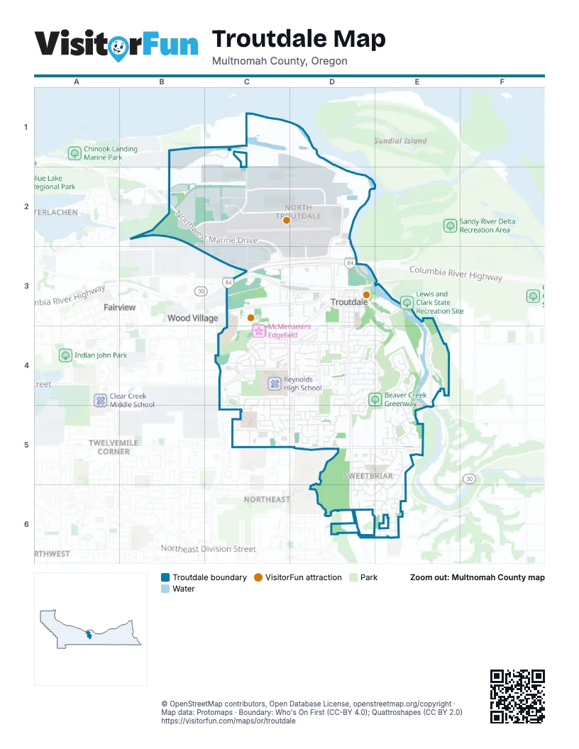
Street index of Troutdale
Each street on the sheet and the grid squares it crosses.
- Columbia River HighwayC3, D3
- Southwest 257th DriveD3, C4, D4, D5
- Northwest Marine DriveB2, C2, C3
- Northwest 257th AvenueD2, D3
- Northwest Frontage RoadC3, D3
- Northwest North Frontage RoadC3, D3
- Northeast 242nd DriveC4, C5
- Northeast 238th DriveC4
- Northeast Hogan DriveC5
- Southeast Stark StreetC5, D5, E5
- East Historic Columbia River HighwayD3, E3, E4, E5
- South Troutdale RoadD4, D5, D6
- Southwest Cherry Park RoadC4, D4
- West Historic Columbia River HighwayC3, D3
- South Buxton RoadD3, D4
- Southeast Troutdale RoadD6
- Northwest Sundial RoadC1, B2, C2
- Northwest Graham RoadC2, D2
- Southwest Halsey StreetC3, D3
- Northwest Swigert WayC2, D2
- Southwest Hensley RoadD4
- Southeast Strebin RoadD6, E6
- Northeast Halsey StreetC3
- Southeast Woodard RoadE4
- Northeast 244th AvenueC3
- Southeast Cochran RoadD6
- South Entrance RoadD2, D3
- East Woodard RoadE4
- Northeast 17th StreetD6
- Southeast Evans AvenueE4, E5
- Southeast Beaver Creek LaneD4, E4, D5
- Northwest Perimeter WayC2, D2
- Southeast Sweetbriar LaneD5, E5, E6
- Southeast Lewellyn AvenueE4, E5
- Southeast Jackson Park RoadE3, E4
- Southeast Harlow AvenueD3, D4, D5
- Southwest McGinnis AvenueC4, C5
- Southwest 22nd StreetC4, D4
- Southwest Corbeth LaneD4, D5
- Southeast Sweetbriar RoadD6, E6
- Southwest Sturges LaneC4
- Southwest 24th StreetC5, D5
- Southeast Sandy AvenueD3, D4
- Southwest 26th StreetC5, D5
- Southwest Wright PlaceD4, D5
- Southeast Pelton AvenueE5, E6
- Southwest 28th StreetC5, D5
- Southwest Kings BywayD3, D4
- Southwest 29th StreetC5
- Southwest Hewitt AvenueD3, D4, D5
- Southeast Chapman AvenueD4, E4
- Southeast 40th StreetD6, E6
- Southwest Edgefield Meadows AvenueC3, D3
- Southwest 25th StreetC5, D5
- Southeast Viewpoint DriveE6
- Southwest 12th StreetC4, D4
- Northwest 257th WayD3
- Southwest Sundial AvenueC4, C5
- Southeast 10th StreetD4, E4
- Southwest 23rd StreetC4, C5, D5
- Southwest 27th WayD5
- Northwest Dunbar AvenueC2, C3
- Southwest Livingston PlaceD3, D4
- Northeast Harlow RoadD2, D3
- Southeast Althaus DriveE5, E6
- Southeast 17th StreetD4, E4
- Southeast Dora AvenueD3, D4
- Southeast Evans LoopE4
- Southwest 15th StreetD4
- Southwest North Star WayC4
- Southwest Kendall CourtD3, D4, D5
- Northwest Rogers CircleC2
- Southwest Laura CourtD4, D5
- Southeast 21st StreetD4
- Southeast 11th CircleD4, E4
- Southeast Kibling AvenueD3, D4, D5
- Southwest Daybreak WayC4
- Southeast 19th StreetD4
- Southeast 18th StreetD4, E4
- Southwest North Star LoopC4
- Southeast 33rd StreetD5, E5
- Southwest 17th WayD4
- Southwest Sunset WayD4
- Northwest 7th StreetC3
- Northwest Corporate DriveC2, C3
- Southwest Spence AvenueD4
- Southwest Lucas AvenueC5
- Southwest Sturges DriveC4
- Southeast Stott CircleD5, D6
- Southwest Montmore WayC4
- Southeast 4th StreetD3
- Southwest Berryessa PlaceC4
- Southwest Indian Mary CourtC4, C5
- Southeast 23rd StreetE5
- Southwest 13th PlaceC4
- Southeast 20th WayE4
- Southeast 3rd StreetD3
- Southeast Stott AvenueD5, D6
- Southwest Stella WayC4
- Southeast 2nd StreetD3
- Southeast Sandy Dell RoadE5
- Southeast Topaz DriveE6
- Southwest 18th WayC4, D4
- Southwest 25th CircleD5
- Southwest Halsey LoopD3
- Southwest Burlingame AvenueD5
- Southeast Midvale RoadE4
- Southeast 34th CircleD5, E5
- Southwest Riverview WayD4
- Southeast 5th StreetD3
- Southeast Hampton LoopE5
- Southwest Chapman AvenueD4
- Southeast 26th StreetE5
- Southwest Imagination WayC4
- Southeast 36th StreetE5
- Northwest Graham CircleC2
- Southwest Edgefield PlaceC3, D3, D5
- Northwest Commerce CourtB2
- Southwest 21st StreetD4
- Southwest 4th StreetD3
- Southwest Cerise WayC4
- Southwest Fox CourtD4, D5
- Southwest 7th StreetD3
- Southwest Fox PlaceD4
- Southwest Napoleon PlaceC4
- Southwest Indian John PlaceC5
- Southwest Hewitt PlaceD5
- Southwest Autumn WayD4
- Southeast Harlow CourtD4, D5
- Southwest Spence CourtD4, D5
- Southeast Dora CourtD4, D5, D6
- Southeast 24th CircleE5
- Southwest Laura AvenueD5
- Southeast Lewis CourtE5
- Southwest 14th StreetD4
- Southwest 27th StreetC5
- Southeast Thompson RoadE4
- Southwest Lancaster CourtC3
- Southeast Hudson CourtE4, E5
- Southeast 35th StreetE5
- Southeast Clark CourtE5, E6
- Southeast 15th StreetD4
- Southwest 11th StreetC4
- Southeast 12th StreetD4
- Southwest Morgan WayD4
- Southeast 29th StreetE5
- Southwest Grant WayD4
- Northwest Eastwind DriveC2, C3
- Southeast 42nd StreetD6, E6
- Southeast 48th StreetE6
- Southwest Clara StreetD4
- Southeast 32nd StreetE5
- Southeast 16th CircleD4
- Southwest 8th CircleD4
- Southwest Crestview WayD4
- Southeast Sandy CircleD5, D6
- Southwest Country Club AvenueC5
- Southeast Chandler AvenueE5
- Southwest Edgefield CourtC3
- Southeast 14th StreetD4
- Southwest 19th PlaceD4
- Southwest 10th StreetC4
- Southwest Wright CourtD4
- Southeast 7th StreetD3
- Southeast 8th StreetD4
- Southwest 18th StreetD4
- Southeast 6th StreetD3
- Southwest 16th WayC4, D4
- Northeast Rene AvenueC5
- Southwest Edgefield AvenueC4
- Southeast 13th StreetD4
- Southwest Indian John AvenueC4, C5
- Southeast 42nd CircleD6
- Southeast 43rd DriveD6
- Southwest 2nd WayD3
- Southeast 29th CourtE5
- Southeast Blake PlaceE5
- Southwest Latourell PlaceC4, C5
- Southeast Knarr CourtD4
- Southeast Jennifer CourtD6
- Southwest Miranda PlaceD4
- Southeast Douglass CourtE5, D6, E6
- Southeast Sandy CourtD4
- Southwest Dunbar PlaceC4, C5
- Southeast Evans CircleE4
- Southwest Edgefield Meadows TerraceC3, D3
- Southwest Tower LaneC5
- Southeast Hampton AvenueE5
- Southeast Kibling CourtD6
- Southwest Brink AvenueC4, C5
- Southwest Larsson AvenueC4
- Mount Hood Medical CenterC5
- Southeast Hood View WayD4
- Southeast Topaz CourtE6
- Southwest Meteor PlaceC4
- Southeast 35th CircleE5
- Southeast 30th CourtE5
- Southwest 19th WayD4
- Southwest Howell AvenueD5
- Southwest 20th WayD4
- Southwest Martine CourtD4
- Southwest Fox AvenueD4
- Southeast 21st CircleE4
- Southwest Haskins CourtD4
- Southeast 48th PlaceE6
- Southwest Elise PlaceD4
- Southeast Hicklin CourtE5
- Southwest Royal Anne AvenueC4
- Southeast Stott CourtD5
- Southwest Sunrise CircleD4
- Northwest Phoenix DriveD3
- Southeast 22nd CircleE4
- Southeast 46th AvenueE6
- Northwest Culpepper DriveD3
- North Entrance RoadC2
- Southeast Hall LaneE5
- Southeast Jones LaneD6, E6
- Southwest 29th WayD5
- Southwest Clara CourtD5
- Southeast Helen CourtE5
- Southwest 23rd CircleC5
- Southeast 28th CourtE5
- Southwest 10th WayC4, D4
- Southeast Lenore CircleE6
- Southwest Wright AvenueD3
- Southwest 30th CourtD5
- Southwest Mitchell CourtC4
- Southwest Opal LaneC5
- Southeast Dix CourtD4
- Southeast Nash CourtE5
- Southwest Spence RoadD4
- Southwest Emerald LaneC5
- Southwest Ruby LaneC5
- Southwest Owens PlaceD3
- Southeast Cereghino PlaceD4
- Southwest 16th CourtD4
- Southwest Dottie CourtC4
- Southwest Hope CircleC5
- Southeast Pioneer LaneE6
- Southwest 27th CircleD5
- Southwest 20th CircleD4
- Southwest 26th CircleC5, D5
- Southwest 9th CircleD4
- Southwest 28th CourtD5
- Southeast Pelton CourtE5
- Southwest Edgefield Meadows CourtC3
- Southwest Kendall AvenueD3
- Southeast Dora StreetD3
- Southeast Kibling StreetD3
- Southwest Fox LaneD5
- Southwest 2nd StreetD3
- Southwest Mitchell AvenueC4
- Southeast 27th StreetE5
- Southeast 19th PlaceD4
- Southwest Burlingame CircleD5
- Southwest Townsend CourtC4
- Southeast 30th PlaceE5
- Southeast 18th PlaceD4
- Southeast Harlow PlaceD4
- Southwest Abbott CircleC5, D5
- Southwest 6th CircleC3, D3
- Southeast 19th CircleE4
- Southwest 14th CircleD4
- Northeast Sundial RoadC1
- Southeast 26th CourtE5
- Southwest 12th CircleD4
- Southwest Faith CourtD5
- Southwest 13th CircleC4
- Southwest 5th WayC3, D3
- Southeast Sweetbriar CourtE6
- Southwest Doolittle CourtD4
- Southeast 43rd CircleD6
- Southwest 15th CourtD4
- Southwest Charity CourtC5
- Southeast Knarr CircleD6
- Southwest 29th CircleD5
- Southwest Harvest PlaceD4
- Southwest Tyson WayC3, D3
- Southwest Brianne CircleD4
- Southeast Celestia CircleD5
- Southwest 17th StreetD4
- Southwest Clawson CircleD4
- Southwest Ellis AvenueC4
- Southwest Rose CourtC5
- Southeast 43rd PlaceD6, E6
- Southeast Stott LaneD6
- Southwest Chapman CourtD4
- Southeast 10th CircleE4
- Southeast Walter CircleE6
- Southeast Penguin PlaceD3
- Southwest Howard PlaceD3
- Southwest Hope CourtC5
- Southwest Alder CircleD4
- Southwest Jennings WayD3, D4
- Southeast 28th PlaceE5
- Southeast Pelton CircleE6
- Southwest Robin CourtD5
- Southeast Berryland CircleE6
- Southwest 19th CircleD4
- Southeast Elizabeth PlaceE5
Things to do on the Troutdale map
Places on the map
- Amazon PDX9
- Barn Exhibit Hall
- Beaver Creek
- Beaver Creek Greenway
- Burlingame East
- Cherry Park Market Center
- Cherry Park Plaza
- Columbia
- Columbia City Park
- Columbia Gorge Premium Outlets
- Company Lake
- CROPS Farm
- Douglas Cemetery
- FedEx Ground
- Glenn Otto Park
- Harlow Canyon
- Helen Althaus Park
- Legacy Church
- Lewellyn Greenway
- Love's Travel Stop
- Mount Hood Community College Greenway
- North Troutdale
- Northwest Self Storage
- Palisades
- Power Station Pub
- Reynolds High School
- Reynolds Metals Company Superfund Site
- Sandee Palisades Park
- Sandy River Greenway
- Sandy Riverfront RV Resort
- Sharon Nesbit Heritage Park
- Strawberry Meadows Greenway
- Sunrise
- Sunrise Park
- Sweetbriar
- Sweetbriar Elementary School
- The Pub Courses at Edgefield
- Town Center
Next to Troutdale
- Fairview
- Interlachen
- North Central
- Northeast
- Northwest
- Twelvemile Corner
- Wood Village
© OpenStreetMap contributors, Open Database License, openstreetmap.org/copyright · Map data: Protomaps · Boundary: Who's On First (CC-BY 4.0); Quattroshapes (CC BY 2.0)















