

Oregon map
Portland Region map
The sheet's index lists 16 highways; US 26, US 30 and I-84 cross the most grid squares. Things to do inside the boundary: 1937 Steiner Log Church, 2Cs Vendor Mall and A Convenient Cycle. Also on it: Beaverton, Canby and Estacada.
Open the map (PDF, US Letter)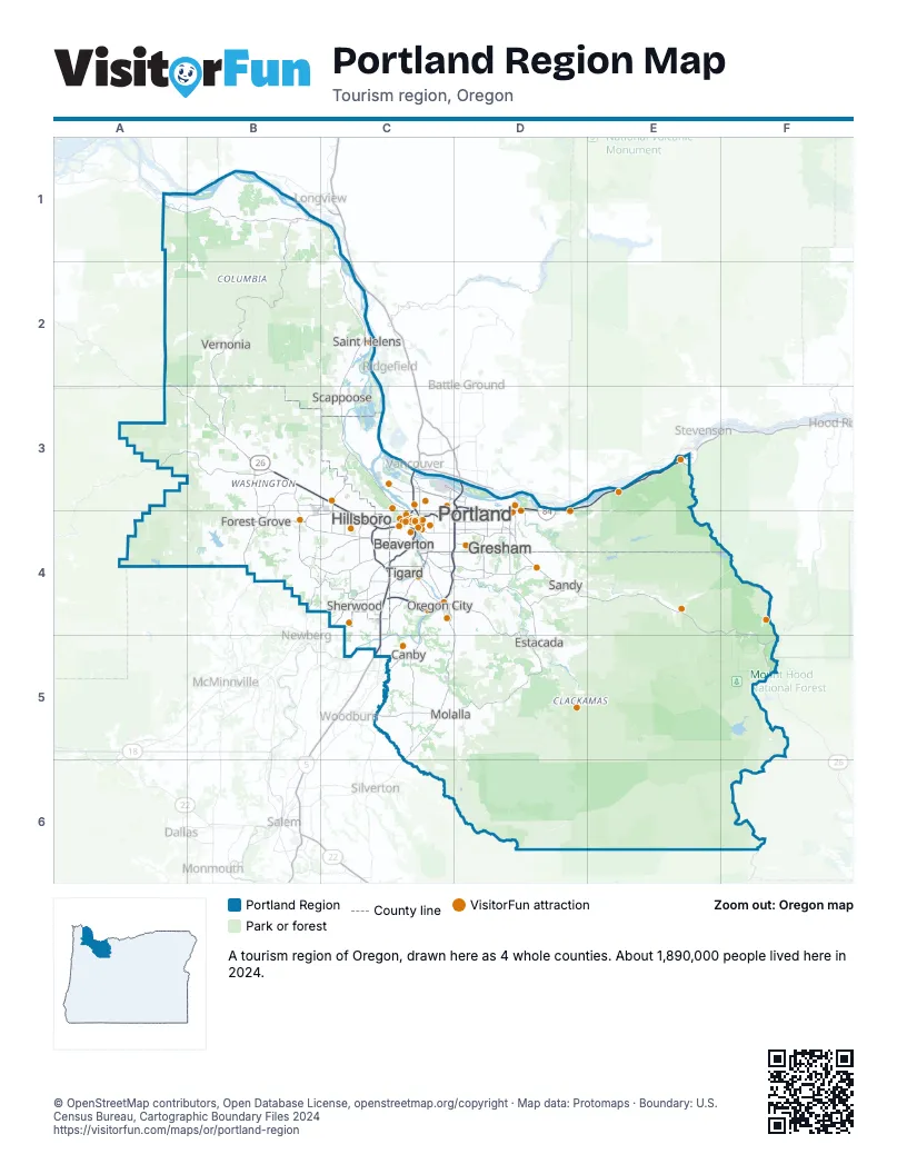
Highway index of Portland Region
Each highway on the sheet and the grid squares it crosses.
- I-5C3, C4, C5
- I-84C4, D3, D4, E3
- I-205C4, D3, D4
- I-405C4
- US 26A2, A3, B3, C3, C4, D4, E4, F4, F5
- US 30A1, B1, C1, C2, C3, C4, D3, D4, E3
- OR 8B4
- OR 47B3, B4
- OR 99EC4, C5
- OR 99WC4
- OR 127C3
- OR 212D4
- OR 213C4
- OR 217C4
- OR 224C4, D4
- OR 551C5
Things to do on the Portland Region map
- 1937 Steiner Log Church
- 2Cs Vendor Mall
- A Convenient Cycle
- Arlene Schnitzer Concert Hall
- Around Portland Tours
- Backstory Books & Yarn
- Betsy & Iya
- Bonneville Lock and Dam
- Bridgeport Village
- Carriage House Lavender
- Cedar Hills Crossing
- Cedartree Hotel
- Clackamas Town Center
- Columbia River Gorge Waterfall Tour
- Crafty Wonderland
- Creo Chocolate
- Deschutes Brewery Portland Public House
- EcoTours of Oregon
- ECOVIBE Alberta Street
- End of the Oregon Trail Interpretive Center
- Envi Adventures
- Fiber Rhythm Craft & Design
- Forest Park
- Freakybuttrue Peculiarium
- Gallery Without Walls
- Gateway to the Gorge Visitor Center
- Gray Line of Portland
- Hillsboro Visitor Information Center
- Historic Willamette District
- Hopscotch Portland
- Huber's Cafe
- International Rose Test Garden
- Lake Oswego Festival of the Arts
- Lan Su Chinese Garden
- Leach Botanical Garden
- Lost Plate Food Tours Portland
- Mark Spencer Hotel
- McMenamins Crystal Hotel
- McMenamins Edgefield
- Mt. Hood Territory
- New Renaissance Bookshop
- North American Bigfoot Center
- Oblation Papers & Press
- Oregon Cheese Trail
- Oregon Historical Society
- Oregon Jewish Museum and Center for Holocaust Education
- Oregon Museum of Science and Industry (OMSI)
- Oregon Zoo
- Park Lane Suites & Inn
- Peak Tours and Transit
- Pioneer Place
- Pittock Mansion
- Portland Aerial Tram
- Portland Art Museum
- Portland By Mouth
- Portland Food Cart Pods
- Portland Japanese Garden
- Portland Saturday Market
- Portland Spirit
- Powell's City of Books
- Sinister Coffee and Creamery
- Skeleton Key Odditorium
- Sunset Esplanade
- Swan Island Dahlias
- Tender Loving Empire
- The Sandy Jug
- The Streets of Tanasbourne
- Third Wave Coffee Tours
- Timberline Lodge
- Tipsy Scoop Portland
- Triangle Wine Country Tours
- Tualatin Valley
- Washington Park
- Washington Square
- Wildwood Adventures
- Willamette Jetboat Excursions
- Wooden Shoe Tulip Farm
- World Forestry Center
- Yellow Castle Bricks
Places on the map
- Beaverton
- Canby
- Estacada
- Forest Grove
- Gresham
- Hillsboro
- Molalla
- Oregon City
- Portland
- Saint Helens
- Sandy
- Scappoose
- Sherwood
- Tigard
- Vernonia
Next to Portland Region
- Mt. Hood & Columbia River Gorge map
- Oregon Coast
- Willamette Valley map
- Southwest Washington
© OpenStreetMap contributors, Open Database License, openstreetmap.org/copyright · Map data: Protomaps · Boundary: U.S. Census Bureau, Cartographic Boundary Files 2024