

Pennsylvania map
Bloomsburg map
About 13,286 people live here (Census Bureau, 2024 estimate). The sheet's index lists 194 streets; Fort McClure Boulevard, Millville Road and Market Street cross the most grid squares. Also on it: Bloomsburg Fairgrounds, Fishing Creek and Bloomsburg Municipal Airport.
Open the map (PDF, US Letter)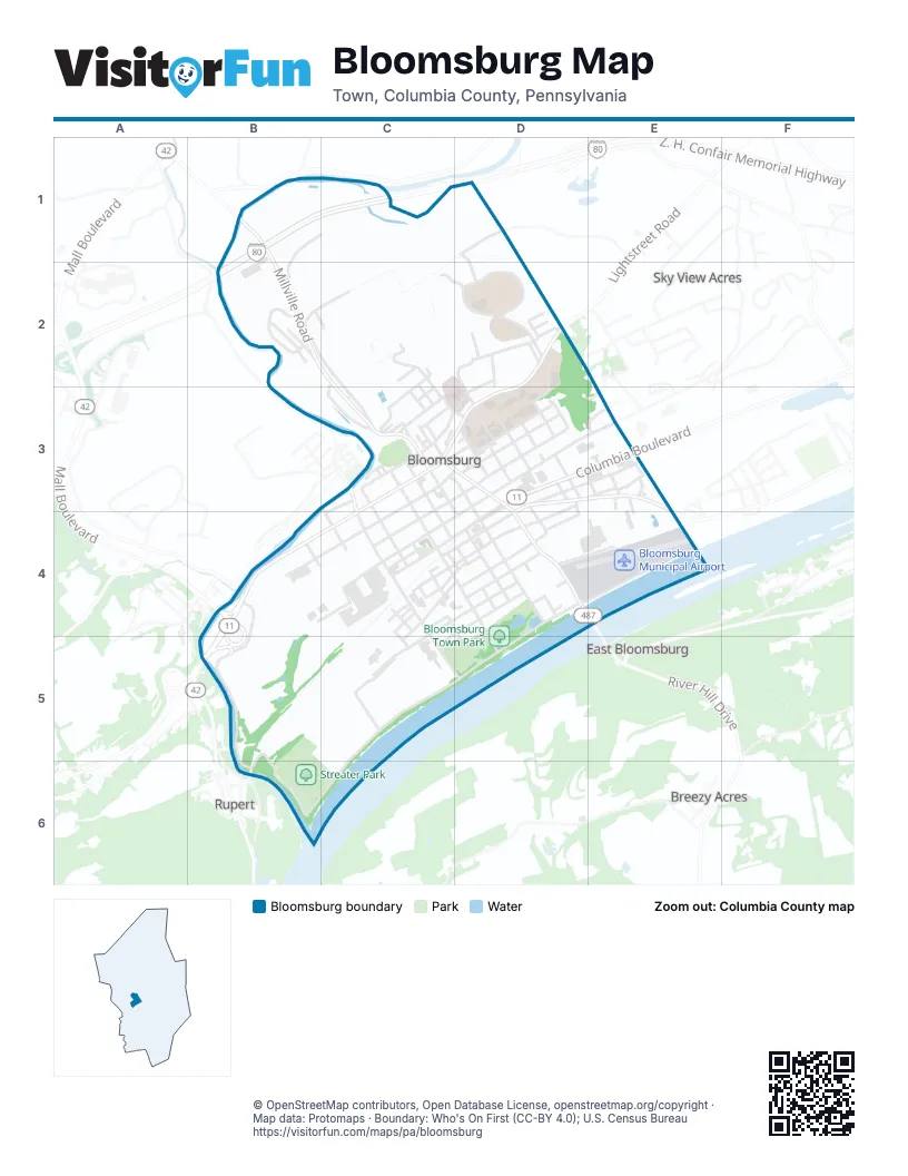
Street index of Bloomsburg
Each street on the sheet and the grid squares it crosses.
- Hemlock LaneB1, C1, B2
- Millville RoadB1, B2, C2, C3
- Z. H. Confair Memorial HighwayB1, C1, B2
- Arbutus Park RoadD1, B2, C2
- Husky HillD1, D2
- Clints LaneB2, C2
- Clover DriveB2
- Kressler AvenueB2
- Summit AvenueB2, C2, C3
- Sunset DriveB2
- Franklin AvenueC2, C3
- Franklin CourtC2
- Irondale RoadC2, C3
- Kozloff DriveC2, D2
- Roongos RidgeC2, D2
- Washington AvenueC2, C3
- Wirt StreetC2, C3
- Bloomsburg Univ EntranceD2
- Country Club DriveD2
- Country Club RoadD2
- East 1st StreetD2, C3, D3
- Hill RoadD2
- Honeysuckle LaneD2, D3
- Hospital DriveD2, C3, D3
- Kent RoadD2
- Lightstreet RoadD2, C3, D3
- McGuire RoadD2
- Montomery Place ApartmentsD2
- Pettit WayD2
- Stuart Edwards DriveD2
- Swisher CircleD2, D3
- Welsh CircleD2
- Westminster DriveD2
- York RoadD2
- Barton AvenueC3, C4
- Blackberry AvenueC3, C4
- Bloom RoadC3
- Catherine StreetC3, D3, D4
- Center StreetC3, C4, D4
- Chestnut AvenueC3, D3
- Chrisman AvenueC3
- Clifton AvenueC3, D3, D4
- Clinton AvenueC3
- East 2nd StreetC3, D3
- East 3rd StreetC3, D3
- East 4th StreetC3, D3, C4
- East Anthony AvenueC3, D3
- East Main StreetC3
- East Pine AvenueC3, D3
- East Ridge AvenueC3
- East StreetC3, D3, D4
- Eyer StreetC3
- Fair StreetC3
- Fetterman AvenueC3
- Glenn AvenueC3
- Hartman AvenueC3, D3
- Iron StreetC3, D4
- Jefferson StreetC3, C4
- Knapp AvenueC3
- Laura AvenueC3
- Leonard StreetC3, C4
- Lincoln AvenueC3
- Lockard AvenueC3
- Market StreetC3, C4, D4, D5
- Miller AvenueC3, C4, D4
- Murray AvenueC3, C4, D4
- North StreetC3
- Oyer AvenueC3, C4
- Penn StreetC3, D3
- Pine StreetC3
- Railroad StreetC3, C4, C5, D5
- Rear Fair StreetC3
- Reservoir StreetC3
- Scott AvenueC3, C4
- Waller AvenueC3
- West 1st StreetC3, B4, C4
- West 3rd StreetC3, B4, C4
- West Anthony AvenueC3, B4, C4
- West Main StreetC3, B4, C4
- West Pine AvenueC3, B4, C4
- West Ridge AvenueC3, C4
- West StreetC3, C4
- Whiteman AvenueC3, C4, D4
- William StreetC3
- Birch StreetD3, D4
- Brugler AvenueD3, C4
- Cherry StreetD3, D4
- Chestnut StreetD3
- Columbia BoulevardD3, E3
- East 5th StreetD3, E3
- East 6th StreetD3, C4, D4
- East 7th StreetD3, E3, C4, D4
- East 8th StreetD3, E3, D4
- East 9th StreetD3, D4
- East Brugler AvenueD3
- East Six and One Half StreetD3, D4
- East Sterner AvenueD3, D4
- Elm StreetD3, E3
- Green AvenueD3
- Laubach DriveD3
- Locust StreetD3
- Naylor AvenueD3, E3
- Oak LaneD3
- Old Berwick RoadD3, E3, D4
- Osuna DriveD3
- Park StreetD3
- Peach AvenueD3, D4
- Pearl StreetD3
- Penn Argyle AvenueD3
- Rear Oak StreetD3, E3
- Rose AvenueD3
- Schuyler DriveD3
- Spruce StreetD3
- Strawberry AvenueD3, D4
- Thorton AvenueD3, D4
- West 5th StreetD3, C4
- Wood StreetD3
- Hazle StreetE3
- Industrial DriveE3, E4
- Maple StreetE3
- Michael DriveE3
- Oak StreetE3
- Patterson DriveE3
- Spyglass Hill DriveE3
- Walnut StreetE3
- 10th StreetB4, D4
- 11th StreetB4
- 11th Street NortheastB4
- 12th StreetB4
- 12th Street NortheastB4
- 3rd StreetB4, C4
- 4th StreetB4
- 5th StreetB4
- 6th StreetB4
- 7th StreetB4
- 8th StreetB4
- 9th StreetB4
- A AvenueB4, C4
- B AvenueB4, C4
- B1 AvenueB4
- Barton StreetB4, C4, C5
- C AvenueB4
- C1 AvenueB4
- D AvenueB4, C4
- E AvenueB4, C4
- F AvenueB4, C4
- Fort McClure BoulevardB4, D4, B5, C5, D5, B6, C6
- Free Stage BoulevardB4
- Herb RowB4
- James AvenueB4, C4
- Machinery RowB4
- Machinery Row NortheastB4
- Mall BoulevardB4
- Montour BoulevardB4, B5
- Orchard StreetB4
- Veterans WayB4
- Washington StreetB4
- West 6th StreetB4, C4
- West Third StreetB4
- 2nd StreetC4
- Bloom StreetC4
- Colonial StreetC4, D5
- Columbia AvenueC4, D4
- Creasy AvenueC4, C5
- Mary AvenueC4
- Reichart AvenueC4
- West 11th StreetC4, D4, C5
- West 4th StreetC4
- West 8 1/2 StreetC4
- West 8th StreetC4, D4
- West 9th StreetC4, D4, C5
- West Brugler AvenueC4
- West Middle AvenueC4
- West Port Noble DriveC4, D4
- West Sterner AvenueC4, D4
- Zehner AvenueC4
- 13th StreetD4
- Airport RoadD4, E4
- Canal StreetD4
- Devon DriveD4
- East 11th StreetD4
- East 12th StreetD4, E4
- East Middle AvenueD4
- East Port Noble DriveD4
- Ferry RoadD4
- Harriet StreetD4
- Park Place ApartmentsD4
- Poplar StreetD4
- River Hill DriveD4, E4
- Town Park VillageD4
- West 12th StreetD4, C5
- West 13th StreetD4, C5, D5
- Sands StreetC5
- Reading StreetB6
Places on the map
- Acedamic Quadrangle
- Applebee's
- Bardo's Tire Sales
- Bastian Tire & Auto Centers
- Bloom'n Thai
- Bloomin' Bagels
- Bloomsburg Dog Park
- Bloomsburg Fairgrounds
- Bloomsburg Hospital Heliport
- Bloomsburg Memorial Elementary
- Bloomsburg Municipal Airport
- Bloomsburg Post Office
- Bloomsburg Public Library
- Bloomsburg Recycling Center
- Bloomsburg Theatre Ensemble
- Bloomsburg Towers
- Bloomsburg Town Hall
- Bloomsburg Town Park
- Bloomsburg University
- Bloomsburg YMCA
- Campus Beer Distributor
- Capitol Bar and Grill
- Columbia County Child Development Program
- Columbia County Courthouse
- Columbia County Domestic
- Fishing Creek
- Geisinger Bloomsburg Hospital
- Intramural Fields
- Practice Field
- Rosemont Cemetery
- Soccer, Lacrosse Field
- Streater Park
Next to Bloomsburg
- Breezy Acres
- East Bloomsburg
- Rupert
- Sky View Acres
© OpenStreetMap contributors, Open Database License, openstreetmap.org/copyright · Map data: Protomaps · Boundary: Who's On First (CC-BY 4.0); U.S. Census Bureau















