

Pennsylvania map
Columbia County map
About 66,012 people live here (Census Bureau, 2024 estimate). The sheet's index lists 300 streets; Mountain Road, Ridge Road and Hollow Road cross the most grid squares. Things to do inside the boundary: Knoebels Amusement Resort.
Open the map (PDF, US Letter)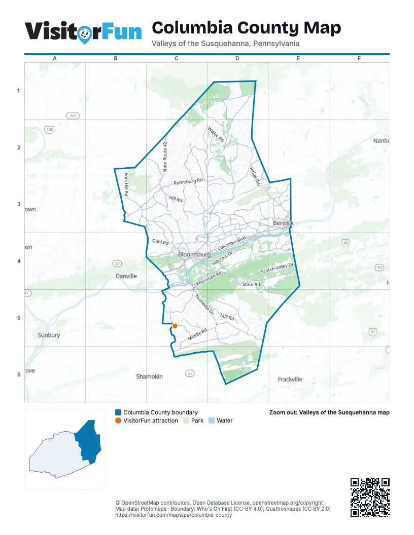
Maps inside Columbia County
1 map inside, from the street map of Columbia County down.
Street index of Columbia County
Each street on the sheet and the grid squares it crosses.
- Z. H. Confair Memorial HighwayC4, D4, E4
- Columbia BoulevardD3, C4, D4
- State Route 42C2, C3
- Southern DriveC5
- Millville RoadC3, C4
- Market StreetD1, D2, E3, C4, D4
- Montour BoulevardC4
- Mall BoulevardC4
- Main StreetD2, D3, C4, D4, D6
- Lightstreet RoadC4, D4
- West Front StreetD3, E3
- Rupert DriveC4
- Mill StreetD2, D3, C4, D4, C5
- East 2nd StreetE3, C4, D4
- Walnut StreetE3, C4
- East Main StreetC3, C4
- West Main StreetC4
- West 2nd StreetE3, D4
- South State StreetC3
- Lunger DriveC4
- North State StreetC3
- East StreetC4
- East Front StreetE3
- South Market StreetE3
- State Route 487D1, D2, C3, D3
- Rohrsburg RoadD2, C3, D3
- State RoadD4, D5, E5
- State Route 118C1, D1
- Buckhorn RoadB3, C3, C4
- State Route 93D3
- Mainville DriveC4, D4
- Numedia DriveC5, D5
- State Route 239C1, D1, D2
- Main Mifflin RoadD4
- Shickshinny RoadD2
- State Route 254C2, D2, D3
- Red Rock RoadD2, D3, E3
- Mifflin Nescopeck HighwayE3, D4, E4
- State Route 442B2, C2, C3
- Numidia DriveD5, D6
- River Hill DriveC4
- White Hall RoadB3
- West 3rd StreetE3, C4, D4
- Aristes Ringtown RoadD6
- Washingtonville RoadB3
- Danville RoadB3
- Jerseytown RoadB3, C3
- Beach Glen RoadD2
- Orange StreetE3
- State Hill RoadD3, E3
- Aristes HighwayD6
- Maple Grove RoadD2
- Iron StreetE3, C4
- Byrnesville RoadD6
- Merceron StreetC4
- Locust AvenueD6
- Benton Shickshinny HighwayD2
- Centre StreetD6
- Poplar StreetC4, D6
- Ferry RoadC4
- Berwick RoadD3
- Mount Carmel-Centralia RoadD6
- Mifflin RoadE3
- North Fourth StreetC4
- Aristes RoadD6
- North Memorial BoulevardD6
- Ridge RoadB2, D2, D3, E3, C4, D4, C5
- Mountain RoadC1, D1, D3, E3, C4, D4, E4, D5
- Old Reading RoadC4, C5, D5
- Old Berwick RoadC4, D4
- Scotch Valley DriveD4, E4
- Green Creek RoadC2, D2, C3, D3
- Beaver Valley RoadD4, E4
- Hill RoadC3, D3, C4
- Middle RoadC5, D5, C6
- Bear Gap RoadC5, D5, C6
- Fowlersville RoadD3, D4
- Hetlerville RoadD4, E4
- Austin TrailC2, C3
- Millertown RoadC3
- Legion RoadC3, C4
- Mill RoadC3, D3, E3, D5
- Zaners Bridge RoadD2, D3
- Pine Swamp RoadC5, D5
- Eagle RoadC2, C3
- Bowmans Mill RoadC3
- Valley RoadB3, E3, C4
- Ringtown Mountain RoadD5
- Sycamore DriveC4, D4
- Frosty Valley RoadC4
- Mount Zion RoadC5
- Knob Mountain RoadD3, E3
- Lower Raven Creek RoadD2
- Central RoadD1, C4, D4
- Draketown RoadD3, D4
- Schoolhouse RoadD3, C4
- Back Branch RoadC4, D4
- Dutch Hill RoadC3, C4
- Zaners Rohrsburg RoadD3
- Wilburton RoadD6
- Mount Pleasant RoadC3, D3
- Grovania DriveC4
- Derrs RoadC2, B3, C3
- Camp Lavigne RoadD1, D2
- Cemetery RoadD2, D3, E3, D4
- East Hillcrest DriveD4
- Evansville RoadD3, E3
- Shaffer RoadD4, E4
- Shultz RoadB3, D3
- Sawmill RoadC2, D4
- Black Run RoadC3
- Quarry DriveC4
- Hidlay Church RoadD3, D4
- Shickshinny Valley RoadE3
- Old Tioga TurnpikeD2, D3
- Kachinka Hollow RoadE3
- Eyers Grove RoadB3, C3
- State Route 1025D3, E3
- Elk Grove RoadD1
- Peewee Hill RoadD4
- Snake RoadD6
- Foundryville RoadE3
- Golf Course RoadD3, D4
- Smith Hollow RoadE4
- Railroad StreetC3, D3, C4
- Stoney Brook RoadC3, D3
- Freas AvenueE3
- County Line DriveC4
- Bloom RoadC4, C5
- Zenith RoadE4
- North Benderton RoadD2
- Red Mill RoadC4
- Big Mine Run RoadD6
- Dairy RoadE3
- Eckroth RoadD3
- Martzville RoadE3
- Lows RoadD3, D4
- Eyersgrove RoadC3
- Lake RoadC3, D3
- Cabin Run RoadD3
- Church StreetD2, E3, C4, D4, D5
- Horse Farm RoadD4
- Brick Church RoadD3
- Summerhill RoadE3
- Paper Mill RoadC4
- East 11th StreetE3, C4
- Little Mountain RoadD5
- Columbia Hill RoadC3, C4
- Rittenhouse Mill RoadD3, E3
- Moores RoadD3
- Summerhill AvenueE3
- Drinker StreetC4
- EyersgroveC3
- Hosler RoadD3
- Twin Church RoadE3
- LaSalle StreetE3
- Water Dam RoadE3
- Fowler AvenueE3
- Perry AvenueC4
- Park RoadE3
- Dutchill RoadC4
- McDowell Hill RoadD3, D4
- Low StreetD4
- Knoebels ParkwayC5
- Edgar AvenueD4
- State Route 3008C5, D5
- Sponenberg Hill RoadD3
- River RoadD3, E3, D4, C5
- Mount Pleasant StreetD3
- North Orchard StreetE3
- Easy StreetC4, D4
- Dump Hill RoadE4
- East Centre StreetD6
- Moore's Hill RoadE3
- Academy StreetD2
- Bear Gap DriveC6
- R C Forest PreserveD5, E5
- Hollow RoadC2, D2, B3, D3, C4, D5
- Orchard DriveC4, C5
- Winding RoadD3, E3
- Wolf House Hollow RoadC2
- Sereno Hollow RoadC2
- Ants Hill RoadB2, B3
- Paper Dale RoadD2, D3
- Church RoadC1, C2, D2, D4
- Maple Ridge RoadB2, C2, C3
- Bottom RoadC3
- Ashton Hollow RoadC5, D5
- West Creek RoadD1, D2
- Spruce Run RoadB2, B3, C3
- Pine Tree RoadC2
- Hartman Hollow RoadD1, C3, D3
- Harrison RoadD3
- Creek RoadC4, D5
- Sones Hollow RoadC2
- Kramer Hill RoadD2, D3
- Dahl RoadC4
- Martenas RoadD3
- Fort McClure BoulevardC4
- Thomas RoadC3, C4
- Waller RoadD2
- Rod And Gun Club RoadC2, C3
- White Horse PikeC2
- Mill Grove RoadD5
- County Line RoadD1, D2, B4, C4
- Savage Hill RoadD3
- Cemetery Hill RoadD2, D5
- Katys Church RoadB2, B3
- Heights RoadE3
- Mystic Mtn Pvt DevD5, D6
- Beech Glen RoadC2
- Distillery Hill RoadC2, D2
- Evergreen LaneD5, C6, D6
- Campbell RoadD1, C2, C5
- Upper Raven Creek RoadD2
- Mifflin XD4
- Oman RoadC3, C4
- Crawford RoadB3, C3
- Mountain Shadow LaneD4, E4
- Independent StreetD5
- Saint Gabriels RoadD1, D2
- Lick Run RoadC3, D5
- Kline RoadC3, D3
- Wintersteen School RoadC2
- Wolf Hollow RoadB2, B3, D4
- Millerstown RoadC3, C4
- Airport RoadB2, D2, C4, D5
- Whites Church RoadC3, C4
- Talmer RoadC2
- Hemlock DriveD2, D3, C5
- Old Greenwood RoadC3
- Fairview DriveC3
- Robbins RoadC3
- Knouse RoadC2, D2
- Tyson School RoadC5, D5
- Poor House RoadD5, D6
- Fritz Hill RoadD1, D2
- Klinger Hill RoadD1, D2
- Cleveland RoadC5
- Black Bear DriveD5
- Long Hollow RoadD5
- Tower DriveC4
- Diehl RoadB3, D4
- Greenhouse LaneE5
- Rarig RoadD5
- Posey Hill RoadD2, D3
- Grouse RoadC2, C3
- Peppermill RoadC3, C4
- Bethel RoadC5
- Yost Hollow RoadD3
- Wagner DriveC4
- Dotyville RoadD2
- Dodson Hill RoadB2, B3
- Happy Valley RoadC5, C6
- Pine StreetD3, E3, C4, D4
- Bendertown RoadD2
- Coles Creek Mill RoadD2
- Chestnut LaneC2
- Dogwood LaneC4, C5, D5, C6
- Mordansville RoadC3
- Phillips RoadB3, C3, E3
- Clyde RoadC2, D2
- Hemlock Hollow RoadC2
- Old State RoadC3
- Saddle Rock RoadD1
- White Church RoadC5, D5
- Taft RoadC5
- Johnson School RoadC5
- Mountain Pink RoadD4
- Creasyville Hollow RoadC2
- Shingle Run RoadC2
- Slabtown RoadC5, D5
- Stevens Hill RoadD1
- Pine Summit Pvt DevD5
- McHenry RoadC2
- Quaker Meeting House RoadD5
- Hawk RoadE3
- Brookside RoadD4, C5, D5
- East 5th StreetE3, C4, D4
- Beagle RoadC2, C3
- Kerkuff RoadD1, D2
- Houck HollowD4
- Cranberry Run RoadE5
- Mendenhall Hill RoadC2, D2
- McHenry Hill RoadD2, C3, D3
- Chestnut StreetE3, C4, D4, D6
- Center School RoadC5
- Brobst DriveC4
- Poorhouse RoadD5
- School House RoadD1, B3, D3
- East 4th StreetE3, C4, D4
- Earth Station RoadC5, D5
- Sunset DriveE3, C4, E4
- Welliversville RoadC3
- Snyder School RoadD4, E4
- Eisenhower RoadC5
- Long Woods RoadC5
- Sportsman Club RoadD3
- Waller Divide RoadC1, C2
- Rakich RoadD1
Things to do on the Columbia County map
Places on the map
- Almedia
- Aristes
- Ashland Anticline
- Bear Gap Reservoir
- Beaver Township
- Benton
- Benton Township
- Berwick
- Berwick Golf Club
- Big Mountain
- Bloomsburg
- Bloomsburg Fairgrounds
- Briar Creek
- Briar Creek Township
- Buckhorn
- Camp Lavigne
- Catawissa
- Catawissa Township
- Centralia
- Centralia Mine Fire
- Centralia Reforestation
- Cleveland Township
- Conyngham Township
- Espy
- Eyers Grove
- Fernville
- Fishing Creek
- Fishing Creek Township
- Foundryville
- Franklin Township
- Greenwood Township
- Hemlock Township
- Iola
- Jackson Township
- Roaring Creek Tract - Weiser State Forest
- State Game Lands Number 226
- State Game Lands Number 329
- State Game Lands Number 55
- State Game Lands Number 58
- Weiser State Forest
Next to Columbia County
- Danville
- Frackville
- Nanticoke
- Shamokin
- Sunbury
© OpenStreetMap contributors, Open Database License, openstreetmap.org/copyright · Map data: Protomaps · Boundary: Who's On First (CC-BY 4.0); Quattroshapes (CC BY 2.0)















