

Pennsylvania map
Delaware County map
About 584,882 people live here (Census Bureau, 2024 estimate). The sheet's index lists 184 streets; West Chester Pike, Mid-County Expressway and Baltimore Pike cross the most grid squares. Things to do inside the boundary: Brandywine Museum of Art.
Open the map (PDF, US Letter)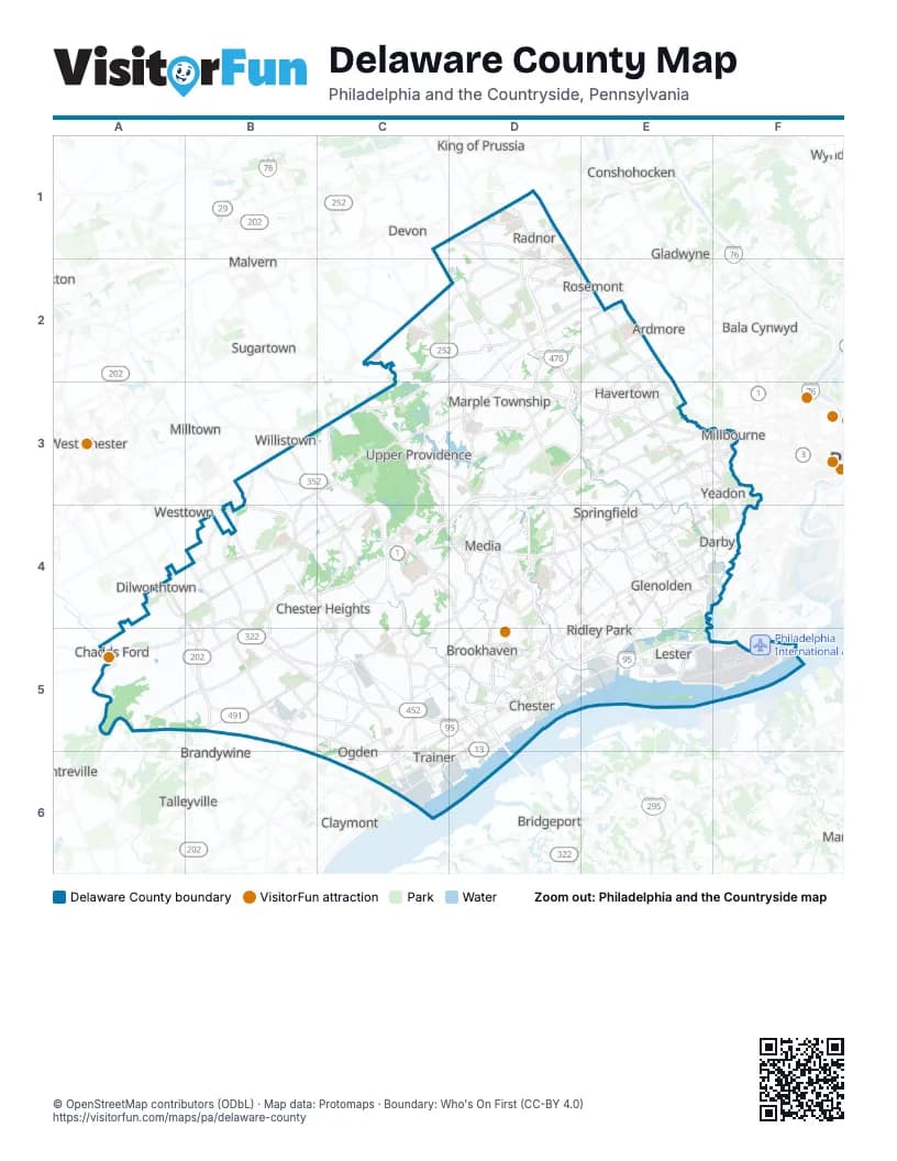
Street index of Delaware County
Each street on the sheet and the grid squares it crosses.
- Conestoga RoadD1, D2, E2
- East Lancaster AvenueD1, D2, E2
- King of Prussia RoadD1
- Matsonford RoadD1
- Mid-County ExpresswayD1, D2, D3, E3, D4, D5
- North Radnor Chester RoadD1
- North Spring Mill RoadD1, D2
- Old Eagle School RoadD1
- South Radnor Chester RoadD1, D2
- South Wayne AvenueD1, D2
- West Lancaster AvenueD1, E2
- Darby Paoli RoadC2, D2
- Goshen RoadC2
- Newtown Street RoadC2, D2, D3
- North Newtown Street RoadC2
- Saint Davids RoadC2, D2
- West Chester PikeC2, D2, C3, D3, E3, F3, E5
- Brooke RoadD2
- Bryn Mawr AvenueD2, D3
- Darby RoadD2, E2, E3
- North Sproul RoadD2, D3
- South Bryn Mawr AvenueD2, E2
- Sproul RoadD2, D3, D4
- Winding WayD2
- College AvenueE2
- County Line RoadE2
- East Eagle RoadE2
- East Haverford RoadE2
- Haverford RoadE2
- Lancaster AvenueE2
- West Darby RoadE2
- West Eagle RoadE2, E3
- West Haverford RoadE2
- Wynnewood RoadE2
- Middletown RoadB3, C3
- Street RoadB3
- North Middletown RoadC3, C4
- North Providence RoadC3, D3, D4
- Providence RoadC3
- Gradyville RoadD3
- Lawrence RoadD3
- Media BypassD3, C4, D4
- Media Line RoadD3
- Palmer Mill RoadD3
- Palmers Mill RoadD3
- South Newtown Street RoadD3
- South Sproul RoadD3
- Springfield RoadD3, E4
- State RoadD3, E3, D4
- West Springfield RoadD3, E3, D4
- City AvenueE3
- Eagle RoadE3
- East Baltimore AvenueE3, F3, D4, E4
- East Manoa RoadE3
- East Marshall RoadE3
- East Plumstead AvenueE3
- East Springfield RoadE3, E4
- East Township Line RoadE3
- Garrett RoadE3, F3
- Lansdowne AvenueE3
- Manoa RoadE3
- Marshall RoadE3, F3
- North Bishop AvenueE3, E4
- North Drexel AvenueE3
- North Eagle RoadE3
- North Lansdowne AvenueE3
- North Manoa RoadE3
- North State RoadE3
- South Eagle RoadE3
- South Lansdowne AvenueE3, E4
- South State RoadE3
- Township Line RoadE3, D5
- West Baltimore AvenueE3, D4, E4
- West Manoa RoadE3
- Baltimore AvenueF3, D4
- Church LaneF3, F4
- Market StreetF3, C5, C6
- North Church LaneF3
- South 69th StreetF3
- South Church LaneF3
- Wilmington PikeA4, B4, B5
- Baltimore PikeB4, C4, D4, E4, A5, B5
- Cheyney RoadB4
- Conchester HighwayB4, B5, C5
- Concord RoadB4, B5, C5, D5
- Valleybrook RoadB4, C4, C5
- Birney HighwayC4, C5
- Llewellyn RoadC4
- North Pennell RoadC4
- Pennell RoadC4, C5
- Smithbridge RoadC4, B5, C5
- South New Middletown RoadC4, D4, D5
- South Pennell RoadC4
- Cedar LaneD4
- Chester RoadD4, D5
- East Knowlton RoadD4
- East Woodland AvenueD4, E4
- Knowlton RoadD4
- Morton AvenueD4, E4, D5
- North Chester RoadD4
- North Monroe StreetD4
- North Swarthmore AvenueD4, E4, E5
- South Chester RoadD4
- South Monroe StreetD4
- South Orange StreetD4
- South Providence RoadD4, D5
- West Sproul RoadD4
- West Woodland AvenueD4
- Chester PikeE4, D5, E5
- East Baltimore PikeE4
- East Oak LaneE4
- Hook RoadE4, F4
- Kedron AvenueE4
- Lincoln AvenueE4, E5
- Macdade BoulevardE4, F4, D5
- MacDade BoulevardE4, D5
- Main StreetE4, F4
- North Macdade BoulevardE4, F4
- North Oak AvenueE4
- North Springfield RoadE4
- Oak LaneE4
- Primos AvenueE4
- South Bishop AvenueE4
- South Macdade BoulevardE4
- South Morton AvenueE4
- South Oak AvenueE4
- South Springfield RoadE4
- West Oak LaneE4
- Woodland AvenueE4, F4
- South 84th StreetF4
- South Cobbs Creek ParkwayF4
- Creek RoadA5
- Foulk RoadB5, C5
- Naamans Creek RoadB5, C5, C6
- Wilmington W Chester PikeB5
- Wilmington West Chester PikeB5
- Aston Mills RoadC5
- Chichester AvenueC5, C6
- Crozerville RoadC5
- Delaware ExpresswayC5, D5, E5, F5, C6
- East Dutton Mill RoadC5, D5
- Garnet Mine RoadC5
- Larkin RoadC5
- Meetinghouse RoadC5, C6
- West Dutton Mill RoadC5
- Avenue of the StatesD5
- Commodore Barry BridgeD5, D6
- East 14th StreetD5
- East 22nd StreetD5
- East 4th StreetD5
- East 9th StreetD5
- Edgmont AvenueD5
- Engle StreetD5
- Highland AvenueD5
- Industrial HighwayD5, E5
- Kerlin StreetD5
- Providence AvenueD5
- Ramp to Commodore Barry BridgeD5
- Route 322 EastD5
- Upland AvenueD5
- West 14th StreetD5
- West 15th StreetD5
- West 2nd StreetD5, D6
- West 4th StreetD5, D6
- West 9th StreetD5, C6
- East Chester PikeE5
- North Governor Printz BoulevardE5
- South Governor Printz BoulevardE5, F5
- South Stewart AvenueE5
- Wanamaker AvenueE5
- Bartram AvenueF5
- 10th StreetC6
- Carpenter Station RoadC6
- East 10th StreetC6
- East Ridge RoadC6
- Hickman RoadC6
- Post RoadC6, D6
- Ridge RoadC6
- Vietnam Veterans Memorial HighwayC6
- West 10th StreetC6
- West Ridge RoadC6
- Wilmington ExpresswayC6
- Commodore John Barry BridgeD6
- Price StreetD6
Things to do on the Delaware County map
Places on the map
- 110 Victory SEPTA Bus Depot
- A East
- A West
- Academy of Notre Dame De Namur
- Airport Business Complex
- Aldan
- Arlington Cemetery
- Aronimink Golf Club
- Aston Township
- Athertyn
- Banjo Town
- Barrett's Meadow
- Bartram Park
- Bethel Township
- Blue Route Inter
- Boeing
- Boeing Helicopters
- Bonner Park
- Boothwyn
- Brandywine Battlefield Park
- Brandywine Circle
- Brinton Run Preserve
- Brookhaven
- Broomall
- Buckeye Booth Station
- Camp Upland Park
- Cardinal O'Hara High School
- Cargo City
- Carroll Park
- Castle Rock
- Chadds Ford Township
- Chanticleer Garden
- Cherry Tree Knoll
- Chester
- Chester Creek
- Chester Heights
- Chester Park
- Chester Rural Cemetery
- Chester Township
- Chew Tract
Next to Delaware County
- Arden
- Ardmore
- Bala Cynwyd
- Brandywine
- Brandywood
- Bridgeport
- Centreville
- Claymont
- Conshohocken
- Devon
- Exton
- Gladwyne
- King of Prussia
- Malvern
- Milltown
- Narberth
- Paoli
- Rosemont
- Spring Mill
- Strafford
- Sugartown
- Talleyville
- West Chester
- Westtown
- Willistown
© OpenStreetMap contributors (ODbL) · Map data: Protomaps · Boundary: Who's On First (CC-BY 4.0)