

Pennsylvania map
Derry Township map
About 25,181 people live here (Census Bureau, 2024 estimate). The sheet's index lists 300 streets; Hersheypark Drive, Sandhill Road and Meadow Lane cross the most grid squares. Things to do inside the boundary: Hershey, Hershey's Chocolate World and Hersheypark.
Open the map (PDF, US Letter)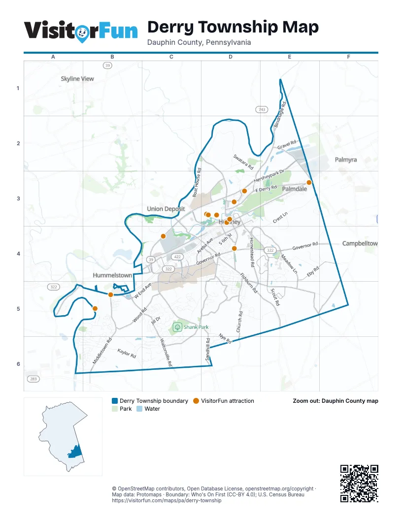
Street index of Derry Township
Each street on the sheet and the grid squares it crosses.
- West Chocolate AvenueD3, C4, D4
- Hersheypark DriveE2, C3, D3, E3, C4
- East Governor RoadD4, E4, F4
- Fishburn RoadD4, D5, E5
- Waltonville RoadB5, C5, C6
- Middletown RoadB5, B6
- East Chocolate AvenueD3, E3
- West Governor RoadC4, D4
- Laudermilch RoadD2, E2, D3
- Cocoa AvenueD3, D4
- North Lingle AvenueE2, E3
- Gravel RoadE2
- Frontage RoadB5
- Park AvenueD3
- Hockersville RoadD4
- Old Laudermilch RoadE2
- Horseshoe PikeF4
- Vine StreetB6
- Homestead RoadD3, D4, D5
- Sand Beach RoadC2, D2, D3
- Walton AvenueC4
- Quarry RoadB5
- Hanover StreetC3
- South Hanover StreetB5
- Homestead LaneD4, E4, E5
- Sandhill RoadD4, C5, D5, D6
- Bachmanville RoadD4, D5, E5
- Meadow LaneD3, D4, E4, E5
- East Derry RoadD3, E3
- Bullfrog Valley RoadC4, C5
- Church RoadD4, D5, D6
- Old West Chocolate AvenueC4, D4
- Wood RoadB5, C5
- Park BoulevardC3, D3, D4
- West Areba AvenueC4, D4
- University DriveC4
- Hilltop RoadD5
- Eby RoadE4, F4
- Roush RoadC5, C6
- Fiddlers Elbow RoadA5
- Stauffers Church RoadF4, E5, F5
- Bindnagle RoadE1, E2
- West End AvenueB5, C5
- Campus DriveC4, C5
- Clark RoadD4, D5
- Hope DriveC4, D4
- North Hockersville RoadC3, C4, D4
- Hotel RoadD3
- Ridge RoadE2, D3, D4
- East Main StreetC4
- Cherry DriveD4
- Northeast DriveD3
- Centerview DriveC4, C5
- East Areba AvenueD3, D4
- Mae StreetC4
- Lucy AvenueC4
- Life Lion DriveC5
- Academic DriveC4
- Smith RoadF4
- Bindnagles RoadE1
- Swatara RoadD2, D3
- Crest LaneE3, E4
- Brookline DriveC5, B6, C6
- Brook DriveE4
- Chocolatetown BoulevardC3, D3, C4
- Raleigh RoadA5, B5, A6, B6
- East Caracas AvenueD3, E3
- Kaylor RoadB6, C6
- Boat House RoadC2, D2, C3
- Stoverdale RoadB5, B6
- McCorkel RoadD5, E5
- Reese AvenueC4
- Deer Run DriveB5
- Springboard RoadB3, C3, C4
- South 3rd StreetD3, D4
- South 2nd StreetD3, E3, D4
- Hill Church RoadC5, D5
- Beech AvenueC4, D4
- Briarcrest DriveC4, D4
- Vista DriveE3, E4
- South 4th StreetD3, D4
- Southpoint DriveB5, B6
- Valley RoadD4, D5
- Police Academy DriveD3
- Grandview DriveE4, F4
- North 1st StreetE3, D4
- Maple AvenueD4
- Heritage LaneD4, E4
- Clearwater DriveC3, C4
- Shopes Church RoadC6
- Crescent DriveC4
- Outlet SquareD3
- Gramercy PlaceB5
- South 1st StreetD3, D4
- West Caracas AvenueD3, D4
- Cedar AvenueD4
- Joann AvenueA6, B6
- Crystal A DriveD3
- Elm AvenueD4
- South 6th StreetD4
- Woodhaven DriveC6
- South 9th StreetD4
- East Granada AvenueD3, E3, D4
- Almond DriveD4
- Jill DriveC5
- Glen RoadD4
- Nye RoadD5, D6
- Leearden RoadD4, D5
- County Line LaneF3, E4, F4
- South 7th StreetD4
- Landvater RoadC6
- Wexford RoadE3, F3
- Pullman WayB6
- Scout RoadE5
- Stone Creek DriveA6, B6
- West Granada AvenueD4
- North 4th StreetE3
- Kieffer RoadD2, D3
- Fairdell DriveB6
- TownhouseC4
- Golf LaneE3
- Bittersweet DriveD5, D6
- Jacobs Creek DriveD5
- Bradley AvenueC5
- Stonegate RoadC5, C6
- Front StreetD3
- Cambridge DriveD4
- Appenzell DriveC5
- Clifton Heights RoadA6, B6
- Gates RoadE5
- Locust StreetD3, A5, A6
- Springboard DriveB3, C3
- Old Hershey RoadE5
- Country LaneD4, E4, E5
- Harding AvenueE3
- Edgewood DriveC5, C6
- Forest AvenueC4, D4
- University Manor EastC4
- North 2nd StreetD3, E3
- Sweet StreetB4, C4
- East Glenn RoadD4
- Nottingham DriveB6, C6
- Quail Hollow RoadC5
- Julianne DriveC5, C6
- Hillcrest RoadD4
- Brownstone DriveD5
- Third StreetD3
- Peggy DriveC5
- Stoney Run RoadC5
- Pennsy Supply RoadC4
- Princeton DriveB6
- Harvey RoadD5
- Wyndham RoadB5, C5
- Orchard RoadD4
- Para AvenueD3, D4
- West Mansion RoadD3
- North 3rd StreetD3, E3
- Highland RoadD4, D5
- Harvest LaneD4, E4
- Carlton RoadD4, D5
- Swatara Creek RoadA6, B6
- Lamp Post LaneD5
- Derry Woods DriveC5
- South 5th StreetD4
- Felty Mill RoadE5, F5
- Peach StreetC4, D4
- Zurich DriveC5
- Hawthorne DriveD6
- Spring Hill DriveC6
- Limerick CourtC5
- Macintosh WayB5
- Carousel CircleD3, E3
- Locust LaneA6, B6
- Flintlock DriveA6, B6
- Hillview LaneC4
- Laurel Ridge RoadD5
- Candlewyk LaneD5
- Sipe AvenueC4
- Sunnyside RoadC5
- Olde Trail RoadC5
- Mill RoadD4
- Trinidad AvenueD3
- Vesper RoadD4, D5
- Reservoir RoadC5
- Second StreetD3, E3
- Fawn LaneB5
- Zermatt DriveC5
- Dunham DriveA5
- Washington AvenueE3
- Mc Kinley AvenueE3
- East Homestead LaneE4
- Chocolate World WayC3, D3
- Palm StreetE3
- Heiden DriveC5
- Randall CircleC5
- Mansion RoadD3
- Robin RoadD4
- Greenlea RoadD4
- Peffley RoadD2
- Draymore CourtC5
- School PlazaD3, D4
- South LaneE3
- Peach AvenueD4
- Deerfield DriveC6
- William DriveD5
- Innsbruck DriveC5
- Oak LaneD4
- Indian Run DriveB5
- Twin Oaks DriveC5
- White Tail DriveB5
- Roosevelt AvenueE3
- Brookside AvenueD5
- Mine RoadD4
- Red Oak LaneD4, E4
- South 8th StreetD4
- Auburn AvenueA6, B6
- Laurel DriveD6
- Meadow WoodC5
- Greystone DriveA6, B6
- Yorktown RoadD5
- Bahia AvenueD3, D4
- Alpine DriveC5
- Pine Tree RoadC5
- 1st Street NorthE3
- Rosedale ApartmentD4
- South Hills DriveC4, D4, C5
- Schoolhouse RoadA6
- Limestone DriveB5
- Cramoor LaneF4
- I StreetD3, D4
- Sweetbay WayD3
- Darthmouth RoadB6
- Hillcrest DriveE3
- Pennland LaneE4
- Chestnut AvenueD4
- International LaneE4, E5
- Meadow Ridge DriveB5
- Creekside DriveB5
- Sylvania RoadD4
- Duryea DriveA6, B6
- Tenby DriveD5
- Carter CoveB6
- Melrose DriveB5
- Half StreetC4, D4
- Chadwick CircleB6
- Walker AvenueE3
- Pear CourtB5
- Cherry LaneD3
- Arrowhead LaneE4
- Boxwood DriveD6
- Laurie AvenueD5
- Sherwood DriveB6
- North Pennland LaneE4
- Hartley RoadD4
- South 5th AvenueD4
- Poplar StreetD3
- Plymouth CircleD5
- Carribean WayE4, E5
- Amber DriveB6, C6
- Olde Course RoadD3
- Roslaire DriveC5
- Spring Creek ManorD3
- Mount Alem DriveC6
- Wilson AvenueE3
- E StreetD3
- Roseland RoadC5
- Fox Glenn DriveC6
- Rhue Haus LaneC5
- Meadow Rose CourtC5
- Springhouse LaneB5
- South Pennland LaneE4, E5
- Ridgeview RoadD5
- Lexington AvenueD5
- B StreetD3
- Cardinal Way RoadC5
- Somerset DriveD4, D5
- Debra RoadC5
- Woodridge DriveC6
- Tallyho DriveD5
- Cord DriveB6
- Long LaneB5, C5
- Locust AvenueD4
- Tice AvenueD5
- Carey WayB6
- Hill Manor DriveD5
- Muhlenburg AvenueD5
- Ethel AvenueC4
- Muirfield DriveB6
- Woodland AvenueD4, D5
- Olde Ventura Farm RoadC5
- Ivanhoe LaneE4
- Colonial WayB6
- Howard AvenueE3
- Grove StreetB5
- Lovell CourtC5
- Swatara AvenueC4, D4
- South Addition DriveC4, C5
- Briarcrest SquareC4
- Miller StreetE3
- Evelina RoadD5
Things to do on the Derry Township map
Places on the map
- Alumni Memorial Grove Park
- Boathouse Park
- Brookside Park
- Founder's Park
- Gelder Park
- Hershey
- Hershey Cemetery
- Hershey Country Club
- Hershey Elementary School
- Hershey Lodge
- Hershey Medical Center Trail System
- Hershey Post Office
- Hershey's Chocolate World
- Hersheypark
- Hersheypark Camping Resort
- Hersheypark Stadium
- Hotel Hershey
- Hummelstown Brownstone Quarries (historical)
- Indian Echo Caverns
- Locustdale Meadow
- Milton Hershey School (North Campus)
- Outlet Square
- Palmdale Park
- Shank Park
- Spring Creek Golf Course
- Tanger Outlets
Next to Derry Township
- Campbelltown
- Hummelstown
- Palmyra
- Skyline View
- Union Deposit
© OpenStreetMap contributors, Open Database License, openstreetmap.org/copyright · Map data: Protomaps · Boundary: Who's On First (CC-BY 4.0); U.S. Census Bureau















