

Pennsylvania map
Dunmore map
About 14,249 people live here (Census Bureau, 2024 estimate). The sheet's index lists 229 streets; Jefferson Avenue, Madison Avenue and East Drinker Street cross the most grid squares. Also on it: Dunmore Cemetery, Dunmore Reservoir Number One and Dunmore School District.
Open the map (PDF, US Letter)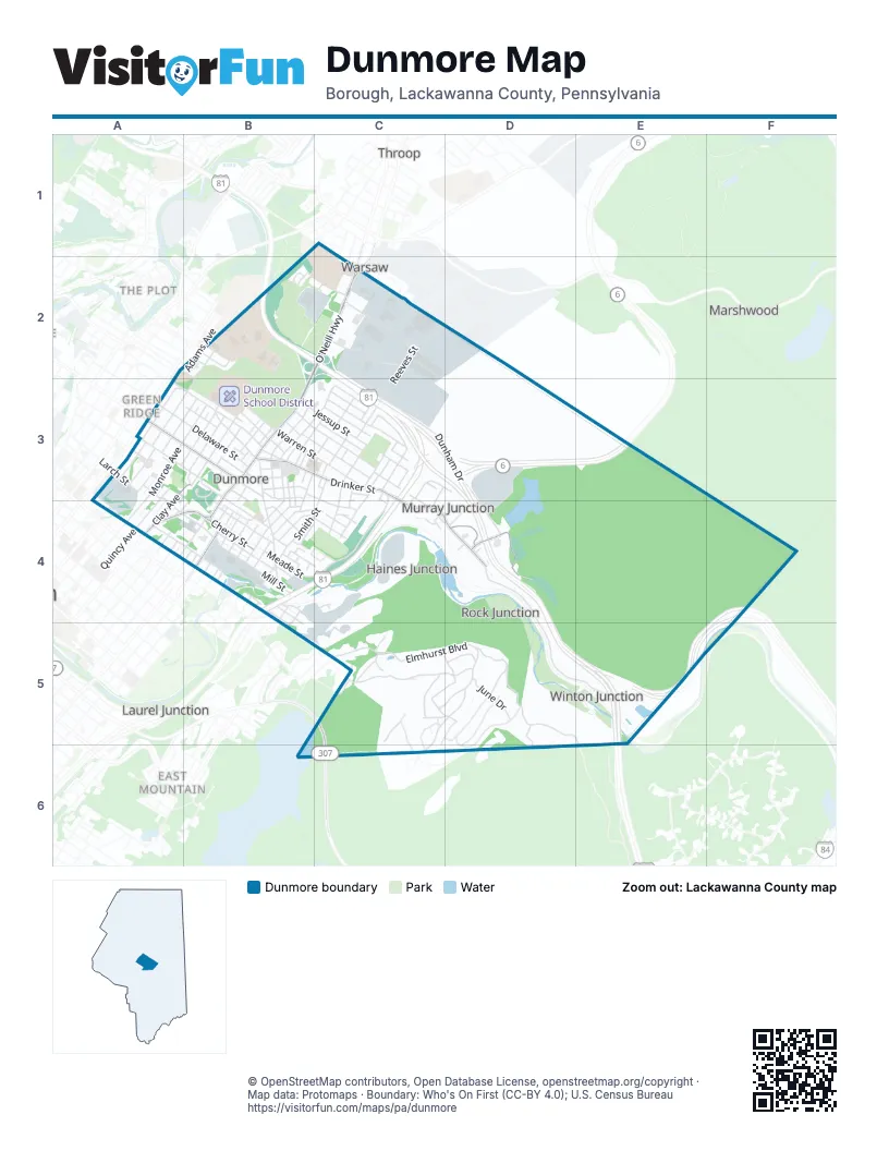
Street index of Dunmore
Each street on the sheet and the grid squares it crosses.
- Line StreetC1, C2
- Wanda StreetC1
- Adams AvenueB2, A3, B3
- College AvenueB2
- Evelyn StreetB2
- Forest Hill Cemetery RoadB2, B3
- Grandview StreetB2
- Jefferson AvenueB2, A3, B3, A4
- Madison AvenueB2, A3, B3, A4
- Richmont StreetB2
- University DriveB2, C2
- Woodlawn StreetB2
- Cameron CourtC2
- Collins CourtC2
- Coppernick StreetC2
- Cypress StreetC2
- Dunmore StreetC2
- East Park RoadC2
- Esther StreetC2
- Keystone Ind Park RoadC2
- Monahan StreetC2
- O'Neill HighwayC2, B3
- Peggy DriveC2, C3
- Phillips StreetC2
- Reeves StreetC2, C3
- Ridgeview DriveC2
- Clay AvenueA3, B3, A4
- Delaware StreetA3, B3
- Electric StreetA3, B3
- Ferguson PlaceA3
- Green Ridge StreetA3, B3
- Harmony CourtA3
- Hitchcock CourtA3, A4
- Holly RoadA3
- Jordan's DrivewayA3
- Larch StreetA3
- Marion StreetA3, B3
- Mc Kenna CourtA3
- Monroe AvenueA3, B3, A4
- New York StreetA3
- Quincy AvenueA3, B3, A4
- West Grove StreetA3, A4
- Ambrose StreetB3
- Andrew StreetB3
- Barton StreetB3
- Blakely StreetB3
- Boyle StreetB3, C3
- Calvin StreetB3
- Center StreetB3, C3, C4
- Chestnut StreetB3, B4
- Church StreetB3
- Corner StreetB3
- Council StreetB3
- Dudley StreetB3, B4
- East Drinker StreetB3, C3, C4, D4
- East Elm StreetB3, B4
- East Pine StreetB3, B4
- East Warren StreetB3, C3
- Elizabeth StreetB3, B4
- Elmont CourtB3
- Exchange CourtB3
- Frank StreetB3
- Franklin StreetB3, B4
- Green StreetB3, B4
- Gulotti DriveB3
- Harper StreetB3
- Harrison StreetB3
- Homestead StreetB3
- Jessup StreetB3, C3
- Keystone CourtB3, B4
- Memorial DriveB3
- Mortimer StreetB3
- North Apple StreetB3
- North Clay AvenueB3
- North Webster AvenueB3, A4, B4
- Oneill HighwayB3
- Potter StreetB3
- Reilly StreetB3
- Rigg StreetB3
- Roosevelt StreetB3
- Sherwood StreetB3, C3
- Shoemaker StreetB3
- South Apple StreetB3
- South Blakely StreetB3, A4, B4
- Spring StreetB3, B4
- Swartz StreetB3
- Throop StreetB3, C3, C4
- Tripp AvenueB3
- Veterans DriveB3
- Ward StreetB3, C3
- Webster DriveB3
- Wert CourtB3
- West Drinker StreetB3
- West Mortimer StreetB3
- West Pine StreetB3
- West Warren StreetB3
- Willow StreetB3, B4
- Wilson CourtB3
- Allen StreetC3
- American Legion Memorial HighwayC3, B4, C4
- Barnard StreetC3
- Battin StreetC3
- Bednar StreetC3
- Brenda LaneC3
- Debbie DriveC3
- Dunham DriveC3, D3, D4
- East Swinick DriveC3
- Field StreetC3, C4
- Flynn StreetC3, C4
- Gibbons StreetC3
- Gilroy StreetC3, C4
- Hill StreetC3, C4
- Jones CourtC3
- Lane StreetC3, C4
- Maloney StreetC3, C4
- Marcus StreetC3
- Marjorie DriveC3
- Meade StreetC3, B4, C4
- Prospect StreetC3
- Reeve StreetC3
- Ross StreetC3, C4
- Salico LaneC3, C4
- Shirley LaneC3
- Smith StreetC3, B4, C4
- Steckel StreetC3
- Swinnick DriveC3
- Thomas DriveC3
- Truman AvenueC3
- Winton StreetC3, D3
- Governor Robert P. Casey HighwayD3, E3
- Keystone Industrial ParkD3, D4
- Buenzli CourtA4
- Costello CourtA4
- East Grove StreetA4, B4
- Farber CourtA4, B4
- Kellum CourtA4
- Mahon CourtA4
- McKenna CourtA4
- North Irving AvenueA4
- Poplar StreetA4
- Taylor AvenueA4
- William StreetA4, B4
- 2nd StreetB4
- 3rd StreetB4
- 3th StreetB4
- 4th StreetB4
- 5th StreetB4
- 6th StreetB4
- Ansden TerraceB4
- Avery PlaceB4
- Brady StreetB4
- Brown CourtB4
- Bunker Hill StreetB4
- Burke StreetB4
- Bush StreetB4, C4
- Butler StreetB4
- Caprio StreetB4
- Charles DriveB4
- Cherry StreetB4
- Cooney StreetB4, C4
- Engle CourtB4
- Engle StreetB4
- Erie StreetB4, B5
- Florentine PlaceB4
- Foote StreetB4
- Gravity StreetB4
- Grove StreetB4
- Helen StreetB4
- Jane StreetB4
- John AvenueB4
- Kurtz StreetB4
- L.A. Verrastro WayB4
- Lake StreetB4
- Laurel StreetB4
- Luke AvenueB4
- Mark AvenueB4
- Mill StreetB4
- Naphin Hill RoadB4
- North Luke AvenueB4
- Oak StreetB4
- Park StreetB4, B5
- Paul AvenueB4
- Philomena DriveB4
- Prescott AvenueB4
- Ridge AvenueB4
- Sand StreetB4, B5
- Short StreetB4
- Somers StreetB4
- Stone AlleyB4
- Sunset DriveB4, C4
- Terrace StreetB4, C4
- Union AvenueB4
- Walnut StreetB4
- West Elm StreetB4
- West Helen StreetB4
- Wheeler AvenueB4
- Branch StreetC4
- Derrig StreetC4, D4
- Hennigan StreetC4
- Lake Scranton RoadC4
- Moritz StreetC4
- Reservoir RoadC4
- River StreetC4
- Varhely StreetC4
- Millett StreetD4
- Old Drinker TurnpikeD4, D5, E5
- Rose DriveD4
- Tigue StreetD4
- April LaneC5, D5
- August AvenueC5, D5, C6
- Baldassari DriveC5
- December DriveC5, D5
- Elmhurst BoulevardC5, D5, E5, E6
- January LaneC5
- March Hill LaneC5, D5
- May DriveC5
- Mia Cara DriveC5
- Moosic StreetC5
- Mount Margaret DriveC5, D5
- September DriveC5, D5
- State Route 307C5, C6
- Tall Trees DriveC5
- Tiffany DriveC5
- William DriveC5
- February DriveD5
- July BoulevardD5
- June DriveD5
- October DriveD5
- Scrub Oak Mountain RoadD5
Places on the map
- A & J Supply Co
- Aaron's Repair / Roadside Repair
- Amico & Sons
- Away Seating
- Azzarelli Professional building Plaza
- Burger King
- Calabria Pizza & Restaurant
- Cali's Don Tomaso Peatza
- Carlucci-Golden-Desantis
- Center for Athletics and Wellness
- Chaplin's Honky Tonk Restaurant & Saloon
- Comfort Inn
- Corleone's Pizzeria
- CVS Pharmacy
- Dailey Resources Welding Supplies and Cylinder Gases
- Denaples Auto Parts
- Denaples Family Community Services Building
- Dunmore Borough Community Center
- Dunmore Cemetery
- Dunmore Health Care Center
- Dunmore High School Football Field
- Dunmore Little League
- Dunmore Lumber
- Dunmore Police Department
- Dunmore Post Office
- Dunmore Reservoir Number One
- Dunmore School District
- Dunmore Senior Center
- Fast Lane Mart
- Fidelity Deposit & Discount Bank
- FNCB Bank
- Forest Hill Cemetery
- Mount Carmel Cemetery
- Number Seven Reservoir
- Saint Anthony's Memorial Park
- Saint Joseph’s Center
- Sherwood Park
- Silver Lake
- Temple Hesed Cemetery
- Villa St Joseph
Next to Dunmore
- East Mountain
- Green Ridge
- Hill Section
- Laurel Junction
- Marshwood
- The Plot
- Throop
- Warsaw
© OpenStreetMap contributors, Open Database License, openstreetmap.org/copyright · Map data: Protomaps · Boundary: Who's On First (CC-BY 4.0); U.S. Census Bureau















