

Pennsylvania map
Gettysburg map
About 8,647 people live here (Census Bureau, 2024 estimate). The sheet's index lists 154 streets; Long Lane, Mummasburg Road and West Broadway cross the most grid squares. Things to do inside the boundary: Civil War Tails at the Homestead Diorama Museum.
Open the map (PDF, US Letter)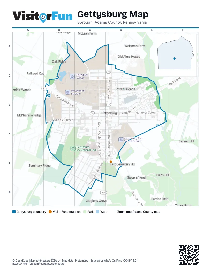
Street index of Gettysburg
Each street on the sheet and the grid squares it crosses.
- Mummasburg RoadB1, C1, C2
- Howard AvenueC1, C2
- Biglerville RoadD1, D2
- West BroadwayB2, C2, D2
- West DriveB2
- West Lincoln AvenueB2, C2, D2
- Bikle AlleyC2
- Brickyard AlleyC2, D2
- College AvenueC2
- Constitution AvenueC2, C3
- CUB DriveC2
- Linbro AlleyC2
- Mummasburg StreetC2, C3
- North Washington StreetC2, C3
- Smith AlleyC2, D2
- West Stevens StreetC2, D2
- Ackerson AlleyD2
- Barbehenn AlleyD2, D3
- Barlow StreetD2
- Carlisle StreetD2, D3
- Coster AvenueD2
- East BroadwayD2
- East Lincoln AvenueD2
- East Stevens StreetD2
- Harrisburg StreetD2
- Hartzell AlleyD2
- Hazel AlleyD2, D3
- Jacobs AlleyD2
- Markley AlleyD2, D3
- Naugle AlleyD2
- North 4th StreetD2, D3, E3
- North Stratton StreetD2, D3
- Pine StreetD2
- Sheely AlleyD2
- Victor StreetD2
- Buford AvenueB3, C3
- Chambersburg RoadB3
- Elm StreetB3
- Hay StreetB3, B4
- North Hay StreetB3
- North Howard StreetB3
- Seminary AvenueB3, C3
- Seminary Ridge AvenueB3, B4
- South Howard StreetB3, B4
- Springs AvenueB3, C3
- Wentz AlleyB3, C3
- Wolf AlleyB3, C3
- Bream AlleyC3, C4
- Chambersburg StreetC3, D3
- Delap AlleyC3, D3
- Gilliland AlleyC3, D3
- Kuhn AlleyC3
- Monument AlleyC3
- North Franklin StreetC3
- South Franklin StreetC3, C4
- South Reynolds StreetC3, C4
- South Washington StreetC3, C4, C5
- West Race Horse AlleyC3, D3
- West Railroad StreetC3, D3
- West StreetC3, C4
- West Water StreetC3, D3
- West Zerfing AlleyC3, D3
- 3rd StreetD3, D4
- Baltimore StreetD3, D4, D5
- Columbia AlleyD3
- East Race Horse AlleyD3
- East Racehorse AlleyD3, E3
- East Water StreetD3
- East Zerfing AlleyD3, E3
- Foth AlleyD3
- Hanover StreetD3, E3
- Hudson AlleyD3, E3
- Liberty StreetD3, D4
- Lincoln SquareD3
- North 3rd StreetD3
- Rabbit/Freedom Transit Buses ONLYD3
- Reaser AlleyD3
- South Stratton StreetD3, D4
- Stauffer AlleyD3, D4
- Strickhouser AlleyD3
- York StreetD3, E3
- 6th StreetE3
- Cannery AlleyE3
- East Middle StreetE3, D4, E4
- East Railroad StreetE3
- Furniture AlleyE3
- Hanover RoadE3
- Little AlleyE3
- North 5th StreetE3
- North 6th StreetE3
- South 4th StreetE3, E4
- South 5th StreetE3
- South 6th StreetE3, E4
- Wye AlleyE3
- Armory RoadB4
- Hamme AlleyB4
- McMillan StreetB4
- Prince StreetB4
- Red Patch AvenueB4
- Ridge AvenueB4
- Shealer LaneB4
- Sickles AlleyB4
- South Hay StreetB4
- West Confederate AvenueB4
- West High StreetB4, C4, D4
- West Middle StreetB4, C4, D4
- Breckenridge StreetC4, D4
- Cemetery AlleyC4
- Dobbin AlleyC4, C5
- Legion AlleyC4, D4
- Levan AlleyC4, D4
- Lincoln LaneC4
- Long LaneC4, B5, C5, B6
- Mayor AlleyC4, D4
- Pape AlleyC4
- Patrick AlleyC4
- Plank AlleyC4
- Reynolds StreetC4
- Schimmelpfennig AlleyC4, D4
- South StreetC4, D4
- United AlleyC4
- Village DriveC4
- Wall AlleyC4, D4
- Warner AlleyC4
- Court AlleyD4, C5, D5
- East Confederate AvenueD4
- East High StreetD4
- East Legion AlleyD4
- Hillcrest PlaceD4, D5
- Lefever StreetD4
- Locust AvenueD4
- Pfeffer AlleyD4
- Roth AlleyD4
- Schoolhouse AlleyD4
- Slentz AlleyD4
- Wade AvenueD4
- Wainwright AvenueD4
- Weaver AlleyD4, D5
- King StreetB5, C6
- Culp StreetC5, C6
- Fairview AvenueC5
- Gettys StreetC5
- Highland AvenueC5
- Hospital AlleyC5
- Johns AvenueC5
- National Cemetery DriveC5, D5
- Noonan AlleyC5
- Park StreetC5
- Queen StreetC5
- Steinwehr AvenueC5, D5, C6
- Sunset AvenueC5, B6
- Taneytown RoadC5
- Baltimore PikeD5
- Evergreen Cemetery DriveD5
Things to do on the Gettysburg map
Places on the map
- 1863 Inn of Gettysburg
- Abdel Ross Wentz Library
- Ace Hardware
- Adams County Courthouse
- Adams County Library
- American Fuel
- American Legion Hall #202
- Bantam Coffee Roasters
- Beer Mart
- Best Western
- Budget Host Three Crowns Motor Lodge
- Casteel Sculptures
- Cemetery Hill
- Christ Chapel
- Christ Evangelical Lutheran Church
- Culp Farm House
- Dobbin House
- Exxon
- Fisher-Sieber Health Center
- Fourscore Beer Company
- Friendly's
- Gallery 30
- Gettysburg
- Gettysburg Area School District
- Gettysburg College
- Gettysburg Community Theatre
- Gettysburg Diorama & History Center
- Gettysburg Dog Park
- Gettysburg Eagles Lodge #1562
- Gettysburg Exxon
- Gettysburg Fire Department Co. #1
- Gettysburg Heritage Center
- Gettysburg Hotel
- Gettysburg Hotel Ballroom
- Gettysburg Municipal Building
- Gettysburg Recreational Park
- Gettysburg, Pennsylvania 17325
Next to Gettysburg
- Benner Hill
- Culps Hill
- East Cemetery Hill
- Iverson's Pits
- McLean Farm
- McPherson Ridge
- Menchey’s Spring
- Oak Ridge
- Old Alms House
- Pardee Field
- Railroad Cut
- Reynolds' Woods
- Seminary Ridge
- Spangler's Spring
- Stevens' Knoll
- Taney Farm
- Weisman Farm
- Ziegler's Grove
© OpenStreetMap contributors (ODbL) · Map data: Protomaps · Boundary: Who's On First (CC-BY 4.0)