

Pennsylvania map
Guilford Township map
About 15,055 people live here (Census Bureau, 2024 estimate). The sheet's index lists 300 streets; Molly Pitcher Highway, Anthony Highway and Swamp Fox Road cross the most grid squares. Also on it: Chambersburg Quarry, Guilford Township Norlo Park and Penn National Golf Course.
Open the map (PDF, US Letter)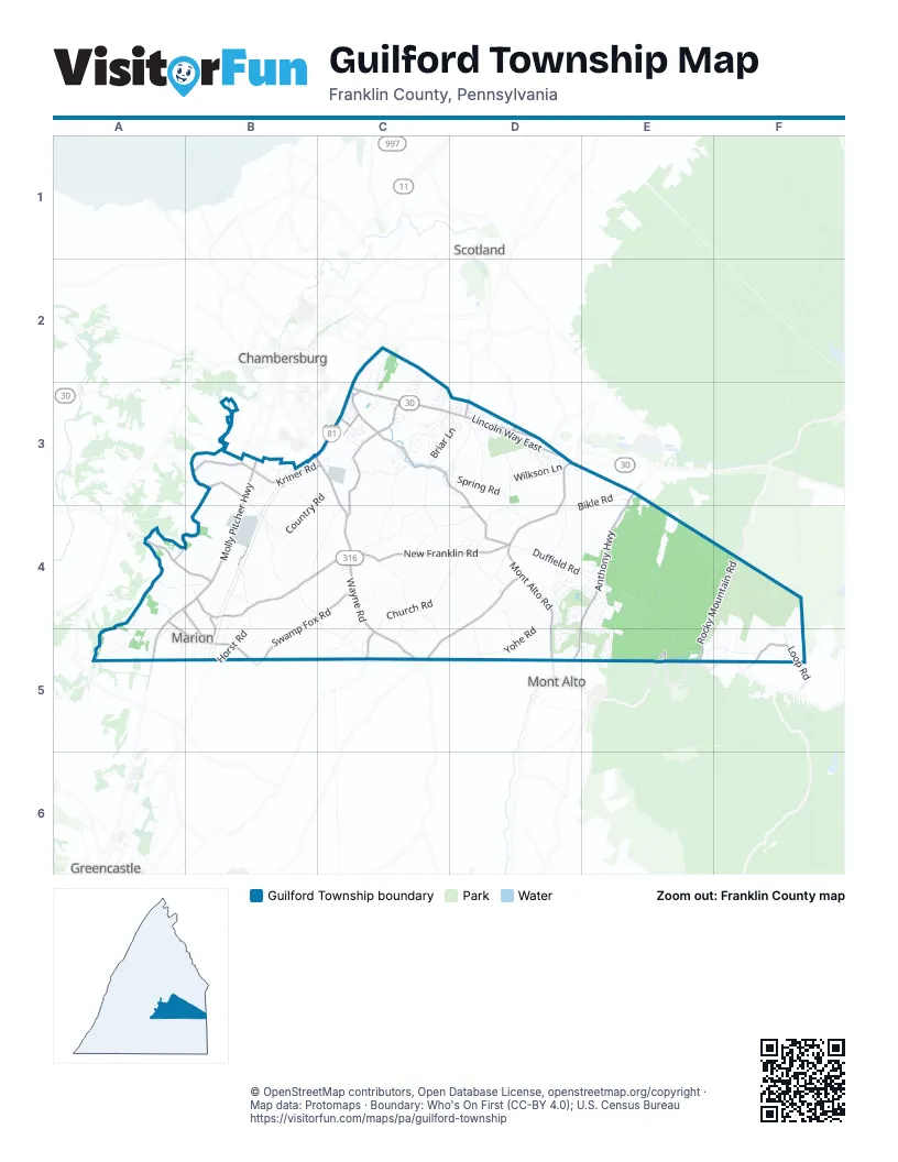
Street index of Guilford Township
Each street on the sheet and the grid squares it crosses.
- Lincoln Way EastC3, D3
- Molly Pitcher HighwayB3, A4, B4, A5
- Wayne RoadC3, C4, C5
- Anthony HighwayE3, D4, E4, D5
- Wayne AvenueC3
- Swamp Fox RoadA4, B4, C4, B5
- Rocky Mountain RoadE4, F4, E5
- New Franklin RoadB4, C4, D4
- Mont Alto RoadD3, D4, D5
- Falling Spring RoadC3, D3, D4
- Loop RoadB3, F5
- Fetterhoff Chapel RoadD4, C5, D5
- Cider Press RoadC3, C4
- Social Island RoadA4, B4
- Kriner RoadB3, C3
- Alleman RoadB4
- West Main StreetD3
- Archer DriveB4, B5
- Colorado StreetA4, A5, B5
- South Edwards AvenueC3
- Grindstone Hill RoadC5
- Shadyside DriveC3
- Etter RoadB3, A4
- Ragged Edge RoadD3
- East McKinley StreetC3
- Woodstock RoadD3
- Boyer Mill RoadB3
- South Mountain RoadE5
- Kettle Springs RoadE4, E5
- Church RoadC4, D4, C5
- Newcomer RoadC3, C4
- Guilford Spring RoadB3, B4
- Spring RoadC3, D3, D4
- Duffield RoadD4, E4
- Country RoadB3, C3, B4
- Springview RoadC3, C4
- Mount Cydonia RoadE4
- Bikle RoadE3, D4, E4
- White Rock RoadE4
- Yohe RoadD4, D5
- Wilkson LaneD3
- Fairway Drive WestD4, E4
- Stone Quarry RoadB4, C4
- Hartzok RoadB4, C4, C5
- Feaster RoadA5
- Eby RoadD3, D4
- Coral Ridge RoadE5, F5
- Horst RoadB4, B5
- Skelly RoadD3
- Guilford Station RoadC4
- Briar LaneC3, D3
- Saint Annes DriveD5, E5
- Lincoln TerraceD3
- Garman DriveC3
- Miller RoadA4, B4
- College RoadC4
- Frederick Mill RoadA4
- Landfill RoadE4
- Main StreetA4, B4, A5
- Franklin Farm LaneC2, C3
- Kennedy StreetA5, B5
- Overhill DriveC3, D3
- Chapel RoadD4, D5
- Fairway Drive EastE4, E5
- Blackbill RoadF4, F5
- Lighthouse RoadB4
- Sollenberger DriveC4, D4
- Henry LaneC3
- McKenzie RoadC4, C5
- Corls Ridge RoadF4, F5
- Spring Valley RoadD3
- Hearthside DriveC3
- Altenwald RoadD4, D5
- Helman RoadB4, C4
- Bent Oak DriveD4
- Brechbill Lp RoadD4
- Olde Pine DriveE4
- Carrera DriveC3
- Pampas CircleD4
- Garber RoadC3
- Mower RoadC2, C3
- Burkholder RoadC4, C5
- Fairway Drive SouthD4, D5
- Greenbriar TerraceD4
- Lincoln DriveD3
- Bowman RoadB3
- Ritchey RoadD3
- Swope RoadA4, A5
- Brechbill Loop RoadD4
- 3rd StreetA4, B4, A5
- Overcash RoadB4
- Stump LaneD4
- Greenbriar LaneD4
- Quarry RoadC3
- Sheller RoadC5
- New Baltimore RoadF4, F5
- Penn National DriveD4, E4
- Alandale DriveD3
- Stitley RoadC4
- Farnhey RoadF5
- Stanley AvenueC3
- Echo DriveC3
- Willowbrook DriveC2, C3
- Front StreetA5, B5
- Larkspur LaneC3
- Poe RoadC4, C5
- WCN DriveB3
- Sandwich LaneE5
- Nitterhaus DriveB3
- Hickory DriveD3
- Augusta NationalE4, E5
- Farm LaneD3
- Range Runner RoadE5
- Turner DriveD3
- Highland RoadC3, D3
- Spyglass Hill DriveD4, E4
- Merion DriveD5
- Cascades DriveD4
- Farmstead DriveD4
- Clubhouse DriveD4
- Parks DriveB4
- Greenfield DriveC2, C3
- Burning Tree TerraceE4
- Wisteria DriveC3, D3
- Social Island CircleA4
- Statler RoadB4
- Wiles RoadD4
- Linden RoadC4
- Fairway OaksE4, E5
- Willow StreetC3
- Kaiser LaneC4, C5
- Hillside DriveD3
- Pine DriveD3
- Congressional TerraceE4
- Field CircleD3
- Quail CircleD4
- McKinley Street ExtendedC3
- Orchard RoadC3, D5, E5
- Springview CircleC3
- Stony Bridge DriveC3, D3
- Old Course RoadE4, E5
- Spruce RoadF5
- Springfield DriveD3
- Angle RoadB5
- Park Terrace DriveC3, D3
- Fox Meadow RoadD3
- Day Hollow RoadF5
- Spring Side Drive EastC3
- Kolpark DriveC3
- Colonial DriveD3
- Harvest LaneD3
- Woodbriar DriveC3
- Crestwood DriveD3
- Pheasant CircleC3
- Heather DriveC2
- Dymond AvenueD3
- Honey Rock RoadC5
- Saucon Valley DriveD5
- Leedy Way EastC3
- Ingram DriveC3
- Greenleaf RoadC3, D3
- Dairy RoadD4
- Saint Johns DriveC3
- Leedy Way WestC3
- Gloss RoadB4, B5
- Valley DriveD3
- New LaneE3
- Oak Leaf Lane NorthD4
- Treeline DriveC3
- Conner DriveB4
- Locust AvenueC3
- 2nd StreetA5
- Joyce DriveD3
- Oak Leaf LaneD4
- Haulman RoadD4
- King DriveE3
- Tower RoadB3
- Hillendale RoadC3, D3
- Farmington RoadC3, D3
- Paper Mill RoadB3
- Crider AvenueD3
- Guilford DriveD3
- Cherry AvenueC3
- Little Mountain TerraceE4
- Township Highway 540B5
- Terrace DriveD3
- Meadow Green LaneD3
- Edgewood CircleC3
- Hillview DriveD3
- Norlo DriveD3
- Ann DriveD3
- Castleton DriveC3
- Lin Mar DriveC3
- Aronimink CircleD4
- Burning Tree LaneE4
- Ragged Edge Road SouthD3
- Seminole WayD5
- Fox Den RoadC3
- Ninth ViewD4
- Highland CircleD3
- Lesher RoadC3
- Greenbriar DriveD4
- Raymond DriveC3
- Woodland WayC3, D3
- Carmack DriveC3
- Country View DriveE3
- Moyle DriveD3
- Homespun DriveC3
- Stullfield RoadC3
- Pullhook LaneE4
- Church LaneC5
- Ivan RoadC4
- Alfalfa LaneD4
- Sandy CircleD3
- Forest LaneD3
- Killarney DriveE5
- Mountain DriveE4
- Strang RoadF4, F5
- Mount View AvenueD3
- Winterberry DriveE3
- Rockview AvenueC3
- Old Guilford Spring RoadB3, B4
- Shively RoadD3
- Limestone DriveC3
- Harbo RoadD3
- Hillcrest DriveC4
- Equestrian DriveD3
- Township Highway 592B5
- Greenlea WayD3
- Hickory LaneC3
- Vernon DriveC3, D3
- McDermott StreetD3
- Crooked Stick WestD5
- Sunny Side DriveD3
- Acorn CircleC3
- Rotz RoadC4
- Hawthorne LaneD3
- Holland RoadD3
- Bradbury CourtC3
- Lehman DriveD3
- Banyan WayC3
- Birchway DriveD3
- Palm Beach DriveC3
- Duck Hook LaneE5
- Franklin DriveC4
- Kunkle DriveC3
- Fersfield RoadD3
- Sunny LaneD3
- Eucalyptus CourtD4
- Summerbridge CourtC3
- Highland DriveA4, A5
- Spring Side CourtC3
- Downey DriveD3
- High StreetB5
- Lytham LaneE5
- Baker RoadF5
- Paul Mar DriveC3
- Hedgerow DriveC3
- Bridle Hill CourtD3
- Willowbrook CourtC3
- Palmetto CourtC3
- Hillen LaneD3
- Tanya DriveB3
- Magnolia CourtD3
- Hunters LaneC3
- Peachtree LaneC3
- Rising Sun LaneC3
- Helman DriveA5
- Prairie DriveC3
- Forest AvenueD3
- Linoak RoadC3
- Tanglewood LaneD3
- Keystone AvenueC3
- Laguna LaneC3
- Railroad StreetE4
- Stonybridge DriveC3, D3
- Springside Drive WestC3
- McIlvaine LaneD3
- Setting Sun LaneC3
- 5th AvenueD3
- Brindle DriveD3
- Midland DriveD3
- Swilkin LaneE5
- Wendy DriveD3
- Crooked Stick LaneD5
- Appleyard DriveC3
- Madison StreetA5
- Juniper RoadC3, D3
- Arbutus DriveC3
- Honey Rock CourtC5
- Walck AvenueA4, A5
- Fayette StreetD3
- Krollman DriveD3
- Marilyn CourtC3
- North Edwards AvenueC3
- Sugar Bush LaneC3
- Aspen LaneC2
- Beamer LaneC3
- Miller DriveD3
- Key West DriveC3
Places on the map
- Act II North
- Agape Fellowship
- Arby's
- Baymont Chambersburg
- Bunting's Fireplace & Stove
- Burger King
- Carter Lumber
- CEB Motors
- Chambersburg Animal Hospital
- Chambersburg Quarry
- Chambersburg Waste Paper
- Cracker Barrel
- Dent Guy
- Dollar Tree
- Dunkin'
- Enterprise
- F&M Trust
- Fayetteville Antique Mall
- Fayetteville Post Office
- Flohr Pools
- Franklin Center
- Grindstone Hill
- Grove Family Library
- Guilford Hills Dental
- Guilford Township Norlo Park
- Harley-Davidson
- Heidelberg Church
- Kettle Springs Mountain
- Little Mountain
- Lowe's
- Meeting of the Pines Natural Area
- Montalto Mountain
- Mount Cydonia Ponds Natural Area
- New Franklin Ruritan
- Norlo Park Softball Complex
- Penn National Golf Course
- Pivot Rock
- Rocky Mountain
- Walmart Supercenter
- White Rocks
Next to Guilford Township
- Chambersburg map
- Greencastle
- Mont Alto
- Scotland
© OpenStreetMap contributors, Open Database License, openstreetmap.org/copyright · Map data: Protomaps · Boundary: Who's On First (CC-BY 4.0); U.S. Census Bureau















