

Pennsylvania map
Hazleton map
About 30,354 people live here (Census Bureau, 2024 estimate). The sheet's index lists 262 streets; East Broad Street, South Poplar Street and Arthur Gardner Highway cross the most grid squares. Also on it: Grand Central Plaza, Hazle Cemetery and Hazleton Little League Complex.
Open the map (PDF, US Letter)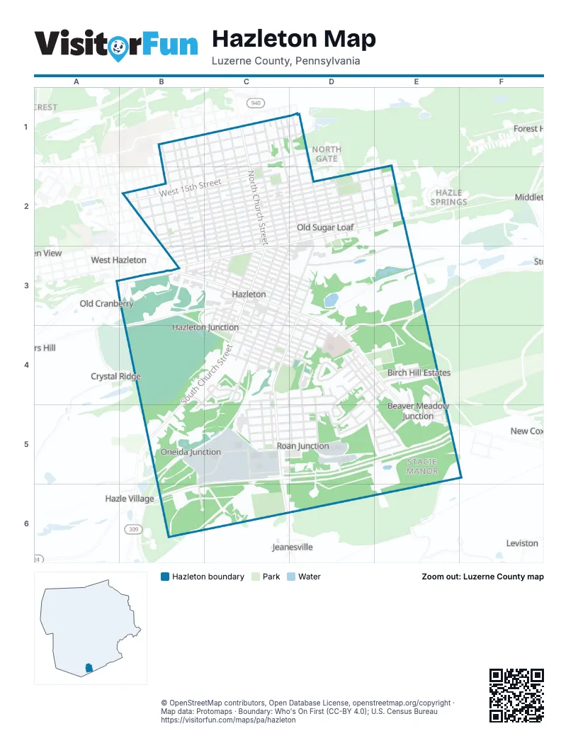
Street index of Hazleton
Each street on the sheet and the grid squares it crosses.
- Clinton CourtB1, B2, B3
- Grant StreetB1, B2, B3
- Hanover CourtB1, B2, C2, C3
- Lincoln StreetB1, B2, B3
- North James StreetB1, B2, C2, C3
- Peace StreetB1, B2, C3
- Penn CourtB1, C1, C2, C3
- West 19th StreetB1, C1, B2
- West 20th StreetB1, C1
- West 21st StreetB1, C1
- West 22nd StreetB1, C1, D1
- Wilbur CourtB1, B2, B3
- Alter StreetC1, C2, C3
- Carson StreetC1, C2, D2
- East 17th StreetC1, D1
- East 20th StreetC1, D1
- East 21st StreetC1, D1
- East 22nd StreetC1, D1
- Emerald CourtC1, C2, C3
- Fishers Hill AvenueC1
- Garibaldi CourtC1, C2, D2
- Lafayette CourtC1, C2, C3
- North Church StreetC1, C2, C3
- North Laurel StreetC1, C2, C3
- North Lee CourtC1, C2, C3
- North Locust StreetC1, C2, C3
- North Manhattan CourtC1, C2, C3
- North Sherman CourtC1, C2, C3
- North Vine StreetC1, C2, C3
- North Wyoming StreetC1, C2, D2, C3
- Parkwood StreetC1
- Perry CourtC1, D1, D2
- Seybert StreetC1, D1, D2
- West 17th StreetC1, B2, C2
- West 18th StreetC1, C2
- East 14th StreetD1, C2
- East 15th StreetD1, C2
- Hayes StreetD1, D2
- Meade CourtD1, D2
- Twentieth StreetD1
- Allen StreetB2
- Anchor StreetB2
- Boundary StreetB2, B3
- Branch CourtB2, B3
- East Jefferson AvenueB2
- Liberty CourtB2, B3
- McKinley StreetB2, B3
- McNair StreetB2
- North 4th StreetB2
- North 5th StreetB2
- Roosevelt StreetB2
- State CourtB2
- Washington AvenueB2
- West 10th StreetB2, C2
- West 11th StreetB2, C2
- West 12th StreetB2, C2
- West 13th StreetB2, C2
- West 15th StreetB2, C2
- West 4th StreetB2, C2, B3
- West 5th StreetB2, C2
- West 6th StreetB2, C2
- West 7th StreetB2, C2
- West 8th StreetB2, C2
- West 9th StreetB2, C2
- East 10th StreetC2, D2, E2
- East 11th StreetC2, D2
- East 12th StreetC2, D2
- East 13th StreetC2, D2
- East 1st StreetC2, D2, E2
- East 2nd StreetC2, D2
- East 3rd StreetC2, D2, E2
- East 4th StreetC2, D2
- East 5th StreetC2, D2, E2
- East 6th StreetC2, D2
- East 7th StreetC2, D2, E2
- East 8th StreetC2, D2
- East 9th StreetC2, D2, E2
- West 14th StreetC2
- West 16th StreetC2
- West 1st StreetC2, B3, C3
- West 2nd StreetC2, B3, C3
- West 3rd StreetC2, B3
- West Arbutus StreetC2, D2
- West Aspen StreetC2, C3
- West Diamond AvenueC2, D2, B3, C3
- Arthur StreetD2
- Boone CourtD2
- Cleveland StreetD2
- Columbus CourtD2
- East Arbutus StreetD2, D3
- East Diamond AvenueD2, E2
- Freemont CourtD2
- Garfield StreetD2
- Harrison StreetD2
- Monges StreetD2, E2
- Morris LaneD2
- North Cedar StreetD2, D3
- North Fulton CourtD2, C3, D3
- Scott CourtD2
- Segal CourtD2
- Taylor CourtD2
- Halleck CourtE2
- Lyon CourtE2
- Pardee StreetE2
- Thompson StreetE2
- Wayne StreetA3, B3
- CAN DO ExpresswayB3
- Diamond AvenueB3
- East Broad StreetB3, C3, D3, D4, E4, E5
- East Cranberry AvenueB3, C3, D4
- Harwood RoadB3
- South 4th StreetB3
- South 5th StreetB3
- South Broad StreetB3
- Spruce Street EastB3
- West Broad StreetB3, C3
- West Cranberry AvenueB3
- West Green StreetB3, C3
- West Maple StreetB3, C3
- West Spruce StreetB3, C3
- Cranberry AvenueC3
- Dewey CourtC3
- East Acacia StreetC3, D3
- East Chestnut StreetC3, D3, D4, E4
- East Fern StreetC3, D3
- East Green StreetC3, D3
- East Hemlock StreetC3, D3
- East Holly StreetC3, D3
- East Juniper StreetC3, C4, D4
- East Magnolia StreetC3
- East Maple StreetC3, D3
- East Mine StreetC3, D3, D4, E4
- East Oak StreetC3, D3
- East Spring StreetC3, D3
- East Spruce StreetC3, D3
- East Tamarack StreetC3, D3
- North Bennett CourtC3, D3
- North Linden StreetC3
- North Pine StreetC3, D3
- South Bennett CourtC3, C4
- South Cedar StreetC3, D3, C4, C5
- South Church StreetC3, B4, C4, B5
- South Filmore CourtC3, C4
- South Laurel StreetC3, C4
- South Lee CourtC3, C4
- South Linden StreetC3
- South Locust StreetC3
- South Manhattan CourtC3, C4
- South Pine StreetC3, C4
- South Sherman CourtC3, C4
- South Vine StreetC3, C4
- South Wyoming StreetC3, C4
- West Acacia StreetC3
- West Birch StreetC3, C4
- West Chapel StreetC3, C4
- West Chestnut StreetC3
- West Elm StreetC3, C4
- West Fern StreetC3
- West Hemlock StreetC3
- West Holly StreetC3
- West Juniper StreetC3
- West Magnolia StreetC3
- West Mine StreetC3
- West Oak StreetC3
- West Spring StreetC3
- West Tamarack StreetC3
- West Walnut StreetC3, C4
- Club 40 RoadD3, E3, D4, E4
- Mill StreetD3, D4, D5
- North Poplar StreetD3
- Shaft RoadD3, E3
- South Hazle StreetD3, C4, D4, D5
- South Poplar StreetD3, C4, D4, C5, C6
- South Woodward CourtD3, C4, D4
- Birch Knoll DriveB4, C4, C5
- Newport DriveB4, C4, B5
- A CourtC4, D4, C5
- David RoadC4
- East Beech StreetC4, D4
- East Birch StreetC4, D4
- East Buttonwood StreetC4
- East Chapel StreetC4, D4
- East CourtC4, C5
- East Elm StreetC4, D4
- East Hawthorne StreetC4, D4
- East Hickory StreetC4
- East Noble StreetC4, D4
- East Walnut StreetC4, D4
- Jason RoadC4
- Lahm AvenueC4, D4
- North Pine Tree RoadC4
- Oliver CourtC4, C5
- Samuels AvenueC4, D4
- Sout Cedar StreetC4
- South Fulton CourtC4
- South Pine Tree RoadC4
- West Beech StreetC4
- West Buttonwood StreetC4
- West CourtC4, C5
- West Hawthorn StreetC4
- West Hickory StreetC4
- West Noble StreetC4
- Andrews CourtD4
- Candlewood CircleD4
- Cemetery LaneD4, E4
- Coxe StreetD4, E4, D5
- East Cranberry StreetD4, E4
- East StreetD4, D5
- El Camino RoadD4, D5
- Elm AlleyD4
- Franklin StreetD4
- Harding StreetD4
- Hunter RoadD4
- Lehigh StreetD4, E4
- Luzerne StreetD4, D5
- Mills StreetD4
- Muir AvenueD4, C5, D5
- North Wilson StreetD4, E4
- School RoadD4
- Taft StreetD4
- Terrace BoulevardD4, E5
- Wilson DriveD4
- Wilson StreetD4
- Allen DriveE4
- Amity LaneE4
- Ellie LaneE4
- Harmony DriveE4
- Hilltop RoadE4
- Linda LaneE4
- Mark RoadE4
- Stacie DriveE4, E5
- North Conahan DriveB5, C5, B6
- Arthur Gardner HighwayC5, D5, E5, B6, C6
- B CourtC5, D5
- Berner AvenueC5, D5
- Butler DriveC5
- C CourtC5, D5
- Carleton AvenueC5, D5
- D CourtC5, D5
- Dietrich AvenueC5, D5
- E CourtC5, D5
- F CourtC5, D5
- Kiefer AvenueC5, D5
- Powell DriveC5, C6
- Rocky RoadC5, D5
- Siller DriveC5, D5
- Thirlwell AvenueC5, D5
- Dina AvenueD5, E5
- Dons AvenueD5, E5
- Johns AvenueD5, E5
- Randon LaneD5
- Roberts AvenueD5
- Chrismark RoadE5
- Christopher RoadE5
- Circle DriveE5
- Coach RoadE5
- Estate BoulevardE5
- Ferrara AvenueE5
- Saint Charles DriveE5
- Sharon DriveE5
- Virginia CircleE5
- South Conahan DriveB6
Places on the map
- 12th Ward Park
- Aaron's
- Agudas Israel Cemetery
- Alta Pizzeria & Pasta House
- Altmiller Playground
- Arthur Street Playground
- Bailey's Bark Park
- Beech Street Playground
- Beth Israel Cemetery
- christ luthern church
- CVS Pharmacy
- Giant
- Grand Central Appliance
- Grand Central Plaza
- Harman-Geist Memorial Field
- Hazle Cemetery
- Hazleton Animal Shelter
- Hazleton Area Public Library
- Hazleton City View BMX
- Hazleton Little League Complex
- Holy Rosary Church
- Holy Trinity German R.C. Cemetery
- Holy Trinity R.C. Slovak Cemetery
- Lehigh Valley Hospital-Hazleton
- Lift
- Louis Schiavo City View Park
- Most Precious Blood Cemetery
- Our Lady of Mount Carmel R.C. Cemetery
- Pagnotti Field
- Saint Gabriel's Cemetery
- Saint John the Baptist Polish National Catholic Cemetery
- Saint Michael Ukrainian Catholic Cemetery
- Saints Peter and Paul Lithuanian Cemetery
- Saints Peter and Paul Slovak Lutheran Cemetery
- St Mary's Byzantine Catholic Church
- St Mary's Church Grounds
- St. Mary's Greek Catholic Cemetery
- The Sanctuary
- The UPS Store
Next to Hazleton
- Crystal Ridge
- Green Ridge
- Green View
- Hazle Springs
- Hazle Village
- Hollars Hill
- Jeanesville
- Leviston
- Middletown
- Mount Laurel
- New Coxeville
- North Gate
- Old Cranberry
- West Hazleton
© OpenStreetMap contributors, Open Database License, openstreetmap.org/copyright · Map data: Protomaps · Boundary: Who's On First (CC-BY 4.0); U.S. Census Bureau















