

Pennsylvania map
Kingston map
About 13,476 people live here (Census Bureau, 2024 estimate). The sheet's index lists 148 streets; Rutter Avenue, Market Street and 3rd Avenue cross the most grid squares. Also on it: Wyoming Seminary, Church Street Park and Hamilton Park.
Open the map (PDF, US Letter)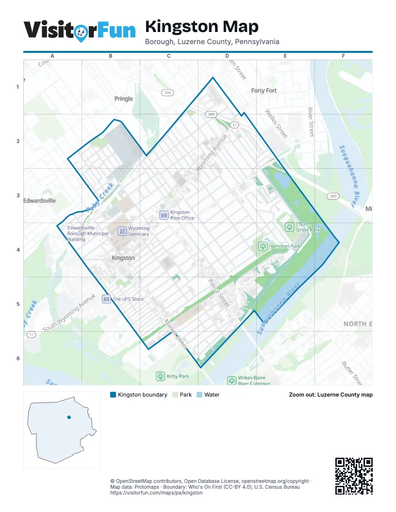
Street index of Kingston
Each street on the sheet and the grid squares it crosses.
- Railroad AvenueC1, D1, C2
- West Vaughn StreetC1, C2, D2
- Carolon DriveD1
- Eley StreetD1, D2
- Floralon DriveD1
- Mercer AvenueD1, C2, D2
- West Bennett StreetD1, D2
- Woodland DriveD1
- Penn StreetA2, B2, B3
- Thomas LaneA2, B2
- Bellas StreetB2
- Brewster LaneB2, B3
- Brook AvenueB2, B3
- East Grove StreetB2
- Edward StreetB2
- Frederick StreetB2, B3
- Gillis StreetB2, B3
- Julian StreetB2, B3
- Korn StreetB2
- Krych StreetB2, B3
- Mason CourtB2
- Meyers LaneB2, B3
- Pringle StreetB2, B3, C3, C4
- Richard StreetB2
- Academy LaneC2, C3
- Division StreetC2, C3
- Elm AvenueC2, B3, C3
- Gordon LaneC2
- John StreetC2, D2
- Lackawanna LaneC2, C3
- Poplar StreetC2, C3
- Price StreetC2, C3
- Schuyler AvenueC2, D2, B3, C3
- Sharpe StreetC2, C3
- Union StreetC2
- Welter LaneC2, D2, C3
- West Dorrance StreetC2, C3
- West Union StreetC2, D2
- Anthracite AvenueD2, E2
- Church StreetD2, E2, E3, E4
- East Bennett StreetD2, D3, E3
- East Union StreetD2, D3
- East Vaughn StreetD2, D3
- East Walnut StreetD2, D3
- Gershom PlaceD2, D3
- Harris StreetD2
- Park PlaceD2, E2
- Stewart StreetD2
- West Walnut StreetD2
- Wyoming AvenueD2, C3, B4, C4
- Rutter AvenueE2, C3, D3, E3, B4, C4
- Center AvenueA3, A4
- Cuba StreetA3, A4
- Curtis StreetA3, A4
- Myers CourtA3, B3
- Cherry StreetB3
- Chestnut AvenueB3, C3, B4
- Eno StreetB3
- Lawrence StreetB3
- Market StreetB3, B4, B5, C5, C6, D6
- Newitt PlaceB3, C3
- North Maple AvenueB3, C3, B4
- Pulaski StreetB3
- Spruce StreetB3, B4
- West Hoyt StreetB3, B4, C4
- Zerby AvenueB3
- Butler StreetC3, C4, D4
- Charles AvenueC3, D3
- East Dorrance StreetC3, D3, D4
- Ford AvenueC3, D3
- Hedge PlaceC3, D3
- James StreetC3, D4
- North Sprague AvenueC3, B4, C4
- Pierce StreetC3, C4, D4, D5
- Reynolds StreetC3, C4, D4, D5
- Ross StreetC3
- Gibson AvenueD3, D4
- Joseph DriveD3, E3, E4
- Lathrop CourtD3
- Lathrop StreetD3, E4
- Meadowland AvenueD3, D4
- Milford DriveD3, E3
- Milton DriveD3
- Sahara DriveD3, E3
- Warren AvenueD3, C4, D4
- Westmoreland AvenueD3, D4
- Holiday CourtE3
- Holiday DriveE3
- Nandy DriveE3, E4
- Stanley DriveE3, E4
- Sylbert DriveE3
- Main StreetA4, B4
- Orchard StreetA4
- Page AvenueA4, B4
- Payne AvenueA4
- Belding LaneB4
- Carle StreetB4, B5
- Covert StreetB4
- Curtis LaneB4
- Luff CourtB4
- Mott AvenueB4
- Northampton StreetB4, B5, C6
- Paddock LaneB4
- Ridge AvenueB4, C4
- South Maple AvenueB4
- South Ridge StreetB4, C4
- South Sprague AvenueB4
- South Wyoming AvenueB4, B5
- Taylor LaneB4, C4
- Wright AvenueB4, C4
- Chester StreetC4, C5
- East Hoyt StreetC4, C5, D5
- North Atherton AvenueC4, C5
- North Landon AvenueC4, B5, C5
- North Loveland AvenueC4, C5
- Osceola AvenueC4
- Tioga AvenueC4, D4, E4, C5
- Winola AvenueC4
- 3rd AvenueD4, E4, C5, D5, C6
- Hamilton AvenueD4, E4
- North Gates AvenueD4, C5, D5
- Keith DriveE4
- Bowman AvenueB5
- Dean CourtB5
- South Atherton AvenueB5, C5
- South Goodwin AvenueB5, C5
- South Landon AvenueB5
- South Loveland AvenueB5, C5
- South Thomas AvenueB5, C5
- South Welles AvenueB5, C5
- 2nd AvenueC5, D5, C6
- Humpleby StreetC5
- Norris StreetC5, C6
- North Goodwin AvenueC5
- North Thomas AvenueC5
- North Welles AvenueC5
- South Gates AvenueC5
- 1st AvenueD5, C6
- Davis StreetD5, D6
- Dawes AvenueD5, C6
- Institute LaneD5
- North Dawes AvenueD5, C6, D6
- North Street BridgeD5
- Parkway BoulevardD5, D6
- South Dawes AvenueD5, C6, D6
- Kirby Park RoadC6
- Crane StreetD6
- Market Street BridgeD6
Places on the map
- Aaron's
- Abe's Hot Dogs
- ALDI
- Arby's
- AutoZone
- Burger King
- Car Lotta Credit
- Chipotle
- Church Street Park
- Citizens Bank
- Community Bank
- Convenient Food Mart
- CVS Pharmacy
- Domino's
- Dorranceton United Methodist Church
- Eyecare Specialist
- Falzone's Service Center
- Fidelity Bank
- First Keystone
- Gateway Car Wash
- Geisinger Medical Group
- Hamilton Park
- Holy Trinity Lutheran Church
- Honesdale National Bank
- Hoyt Library
- Hugh E Boyle and Son
- KFC
- Kingston Indoor Tennis
- Kingston Police Department
- Kingston Pool
- Kingston Post Office
- Kingston Recreation Center
- KIngston Stadium
- Kingza Asian Cuisine
- Korn Street Park
- Kost Tire and Muffler
- Levee Park
- M&T Bank
- United Penn Plaza
- Wyoming Seminary
Next to Kingston
- Edwardsville
- Forty Fort
- North End
- Pringle
© OpenStreetMap contributors, Open Database License, openstreetmap.org/copyright · Map data: Protomaps · Boundary: Who's On First (CC-BY 4.0); U.S. Census Bureau















