

Pennsylvania map
Lancaster Township map
About 58,441 people live here (Census Bureau, 2024 estimate). The sheet's index lists 238 streets; Wabank Road, Millersville Road and Hamilton Road cross the most grid squares. Things to do inside the boundary: LancasterHistory.
Open the map (PDF, US Letter)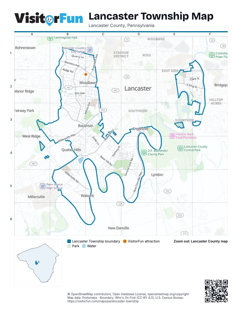
Street index of Lancaster Township
Each street on the sheet and the grid squares it crosses.
- Center RoadB1
- Hamilton RoadB1, C1, B2
- Hillcrest RoadB1, C1
- Homestead LaneB1
- Marietta AvenueB1, C2
- Newton RoadB1, C1
- Orchard LaneB1
- Quarry LaneB1, C1
- Ridge RoadB1, B2
- River DriveB1, B2
- Valley RoadB1, C1
- Wilson DriveB1, B2
- North President AvenueC1, C2
- North School LaneC1, B2
- West James StreetC1
- East Walnut StreetE1, E2
- Grofftown RoadE1, E2
- Riverside AvenueE1, F1, F2
- Abbeyville RoadB2, B3
- Alley RB2
- Alley SB2, B3
- Alley TB2
- Alley UB2
- Belle Valley RoadB2
- Cheves PlaceB2
- Columbia AvenueB2, C2
- Devon DriveB2, B3
- Elm AvenueB2, C2
- Fieldstead LaneB2, B3
- Gordon RoadB2
- Hillside DriveB2
- Jackson DriveB2
- Maple AvenueB2, C2
- Meadowbrook RoadB2
- Meadowcreek LaneB2, B3
- New Garden AvenueB2
- Oak LaneB2
- Perry AvenueB2
- School LaneB2
- South President AvenueB2, C2, B3
- South School LaneB2, B3
- Spring Grove AvenueB2, C2
- Wheatland AvenueB2, C2
- Wickford RoadB2
- Wilson AvenueB2
- 1st StreetC2
- 3rd StreetC2
- 4th StreetC2
- Alley HC2
- Alley IC2
- Alley JC2
- Alley KC2
- Alley LC2
- Alley MC2
- Alley NC2
- Alley OC2
- Alley VC2, B3
- Alley WC2, C3
- Alley XC2, C3
- Atkins AvenueC2, B3, C3
- Buchanan AvenueC2
- Edgewood AvenueC2
- Ellwood AvenueC2
- Prangley AvenueC2
- Race AvenueC2
- Rider AvenueC2
- South West End AvenueC2, C3
- Spencer AvenueC2, B3, C3
- Watson AvenueC2
- West StreetC2
- Woods AvenueC2
- Alley AE2
- Alley BE2
- Alley CE2
- Alley DE2
- Alley EE2, F2
- Alley FE2
- Alley GE2, F2
- Betz RoadE2
- City Mill RoadE2, F2
- Clark StreetE2, F2
- Conestoga DriveE2, F2
- Conestoga Woods RoadE2, F2
- Cottage AvenueE2
- East King StreetE2, F2
- East Orange StreetE2, F2
- Jamaica RoadE2, F2
- Nassau RoadE2
- Parkside AvenueE2, F2
- Ranck AvenueE2
- Ranck Mill RoadE2, F2
- Conestoga BoulevardF2, F3
- Conestoga RoadF2
- Garden City DriveF2
- Glenwood AvenueF2
- Landis DriveF2, F3
- Milford DriveF2
- North Conestoga DriveF2
- Willis LaneF2
- Woodlyn CourtF2
- Bentley LaneA3, B3, B4
- Armel DriveB3
- Bean Blossom DriveB3
- Big Bend RoadB3
- Davis DriveB3, C3
- Edgehill DriveB3, C3
- Hamilton Park DriveB3, C3
- Manor House LaneB3
- Michelle DriveB3, B4, C4
- Millersville PikeB3, C3, B4
- Montrose AvenueB3, C3
- North Bausman DriveB3
- Passey LaneB3
- Saint Paul CircleB3, B4
- Schoolhouse RoadB3
- September DriveB3
- Springhouse RoadB3, C3
- Springside DriveB3
- Westview DriveB3
- 5th StreetC3
- 6th StreetC3
- Alley QC3
- Calvert LaneC3
- Charles RoadC3
- Euclid AvenueC3
- Fairview AvenueC3, D3
- Grandview AvenueC3
- Judie LaneC3, C4
- Manor StreetC3
- Penrose AvenueC3
- Rosedale AvenueC3
- Roselawn AvenueC3
- Roselle AvenueC3
- Saint Joseph StreetC3
- Wabank RoadC3, A4, B4, C4
- Winthrop DriveC3
- New Danville PikeD3, D4, D5
- South Prince StreetD3
- South Queen StreetD3
- Willow Street PikeD3
- South Duke StreetE3
- Dogwood LaneF3
- Holly LaneF3
- Red Maple RoadF3
- Landis AvenueA4
- Lynne LaneA4
- Millersville RoadA4, B4, B5, C5
- Stratford RoadA4
- Bentley SummitB4
- Betz Farm DriveB4
- Cold Stream DriveB4
- Crossfield DriveB4
- Crown Colony DriveB4
- Deep Hollow LaneB4, C4
- Drummers LaneB4
- Farm LaneB4
- Gable Park RoadB4
- Gentlemens WayB4
- Goldenfield DriveB4, B5
- Green Hills DriveB4
- Greythorne RoadB4
- Jennings DriveB4, C4
- Meadowcroft DriveB4
- Mill Pond DriveB4
- Park LaneB4
- Pilgriim DriveB4, B5
- Pilgrim DriveB4
- Ridgewood RoadB4
- Saint Phillips DriveB4
- Southbrook DriveB4
- Spring Ridge LaneB4
- Timber Point LaneB4
- Townsend CourtB4
- Townshed CourtB4
- Waterleaf RoadB4
- Waypoint DriveB4, B5
- Baun StreetC4
- Bean Hill RoadC4, D4
- Chadwick CircleC4
- Colchester DriveC4
- Dante BoulevardC4, D4
- Eliot StreetC4, D4
- Elmshire DriveC4, D4
- Kensington RoadC4
- Kensington TerraceC4
- Kentshire DriveC4, D4
- Lanarkshire DriveC4
- Lefever AvenueC4
- Misty DriveC4
- North Field DriveC4
- North Pier DriveC4, C5
- Pennshire DriveC4, D4
- Rabbit Hill LaneC4
- Rock Ledge CourtC4, D4
- Salvatore CourtC4
- Southport DriveC4, C5
- Sterling PlaceC4, D4
- Twain StreetC4, D4
- Veme RoadC4, D4
- Voltaire BoulevardC4, D4
- Waterford CourtC4
- White Water RoadC4
- Wilderness RoadC4, C5
- Wyncroft LaneC4
- Wyncroft TerraceC4
- Brewster DriveD4, D5
- Clarendon DriveD4, D5
- Descartes DriveD4
- Dickens DriveD4
- Fairfax DriveD4
- Galt DriveD4
- Grafton CircleD4, D5
- Malory StreetD4
- Perthshire DriveD4
- Pickford DriveD4
- Poe StreetD4
- Second Lock RoadD4, D5
- Stockbridge CircleD4
- Turnbridge DriveD4, D5
- Westmore WayD4
- Yardley GreenD4
- Yorkshire DriveD4
- Barbara StreetB5
- Baron DriveB5
- Barton DriveB5
- Dylan LaneB5
- East Cottage AvenueB5
- Edington PlaceB5
- Green Spring CircleB5
- Honeysuckle LaneB5
- Hull CourtB5
- Livingston LaneB5
- Millrace DriveB5
- Rice RoadB5, C5, C6
- Water Valley RoadB5
- Rosewood DriveC5
- Hoover RoadD5
- Wildflower LaneD5
Things to do on the Lancaster Township map
Places on the map
- Advance Auto Parts
- Burrowes Elementary School
- Comet Field
- Conestoga Memorial Park
- Conestoga Restaurant
- Conestoga View
- Crossway Church
- DaVita Dialysis
- Degel Israel Cemetery
- Degel Israel Congregation
- Dominion Pizza
- Elizabeth R. Martin Elementary School
- Giant
- James Buchanan Elementary School
- Lancaster Community Park
- Lancaster First Assembly of God
- Lancaster Historical Society
- Lancaster Pet Cemetary
- Lancaster Township Fire Department
- Lancaster Township Municipal Building
- Maple Grove Park
- Millersville Mart
- Planet Fitness
- PNC Bank
- President James Buchanan's Wheatland
- ProMedica Skilled Nursing and Rehabilitation (Lancaster)
- Providence Place Senior Living of Lancaster
- Queen Pharmacy
- Ramirez Auto Repair
- Regal Manor Stadium 16
- Saint Anthony's Cemetery
- Saint Josephs New Catholic Cemetery
- Stone Mill Shopping Center
- The Castle Roller Skating Rink
- The Church of Jesus Christ of Latter-day Saints
- The UPS Store
- Way of Jesus Fellowship
- Wheatland
- Windolph Landing Nature Preserve
- Windolph Landing Park
Next to Lancaster Township
- Bridgeport
- Cabbage Hill
- Central Business District
- Chestnut Hill
- Churchtowne
- College Park
- Colonial Manor
- Conestoga Gardens
- Conestoga Heights
- East Side
- Fairway Park
- Garden Hills
- Grandview Heights
- Hilltop Acres
- Lancaster map
- Linville Circle
- Lyndon
- Manor Ridge
- Millersville
- Musser Park
- Mussertown
- New Danville
- Pheasant Ridge Mobile Home Park
- Prospect Heights
- Quaker Hills
- Rohrerstown
- Ross
- Rossmere
- Southside
- Stadium District
- Stevens
- Sunnyside
- West End
- West Lancaster
- West Ridge
- Wheatland
- Wynn Wood Manor
© OpenStreetMap contributors, Open Database License, openstreetmap.org/copyright · Map data: Protomaps · Boundary: Who's On First (CC-BY 4.0); U.S. Census Bureau















