

Pennsylvania map
New Castle map
About 21,332 people live here (Census Bureau, 2024 estimate). The sheet's index lists 300 streets; East Washington Street, Highland Avenue and North Croton Avenue cross the most grid squares. Things to do inside the boundary: Lawrence County, PA.
Open the map (PDF, US Letter)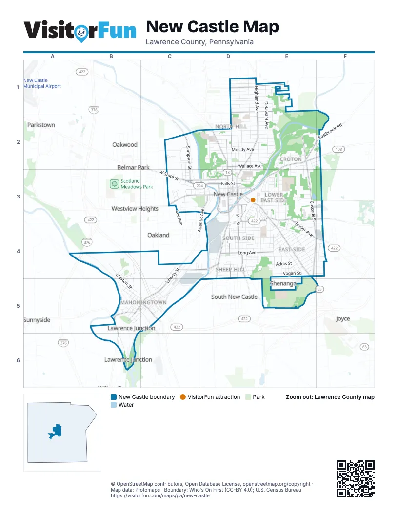
Street index of New Castle
Each street on the sheet and the grid squares it crosses.
- Beaver Valley ExpresswayA4
- East Washington StreetD3, E3, E4, E5
- North Croton AvenueE2, D3, E3
- West Falls StreetC3, D3
- South Jefferson StreetD3, D4
- North Liberty StreetC4, B5, C5
- Butler AvenueE3, E4, F4
- Sampson StreetC2, C3
- Moravia StreetD3, D4, D5
- North Jefferson StreetD2, D3
- Montgomery AvenueB5, B6
- Mahoning AvenueC4, D4
- West State StreetC3
- Wilmington RoadD2
- South Croton AvenueD3
- South Liberty StreetB5
- New Butler RoadF4
- Highland AvenueD1, D2, E2, D3
- North Columbus InnerbeltD3
- West Washington StreetC3, D3
- Eastbrook RoadE2, F2
- Taylor StreetD3, E3
- Shadyside StreetD3
- Grove AvenueD3
- Neal StreetD3, D4
- North Mill StreetD3
- Mount Jackson RoadB5
- South Cascade StreetE3, E4, F4
- North Mercer StreetD2, D3
- South Mill StreetD3, D4
- East Hazelcroft AvenueD1, E1
- North Cascade StreetE2, E3
- West Grant StreetC3, D3
- East Long AvenueD4, E4
- East Clen Moore BoulevardD1, E1
- Pennsylvania AvenueD4, E5
- East Wallace AvenueD2, E2
- Frew Mill RoadE3, F3
- Atlantic AvenueD3
- East Cherry StreetC5
- East North StreetD3
- East Falls StreetD3
- West Long AvenueD4
- Huron AvenueE3, E4, E5
- Carlisle StreetD1, D2
- Delaware AvenueE1, E2
- North Cedar StreetC4, C5
- Neshannock AvenueE2, D3, E3
- East Hillcrest AvenueD1, E1
- Albert StreetD1, D2
- Neshannock BoulevardE1, E2
- East Edgewood AvenueD1, E1
- Industrial StreetC4, C5
- East Fairmont AvenueD1, E1
- East Lutton StreetD4, E4
- Court StreetD3, E3
- East Moody AvenueD2, E2
- East Leasure AvenueD2, E2
- East Meyer AvenueD1, E1
- Blaine StreetD2, D3
- Cunningham AvenueE3, E4
- East Reynolds StreetD4, E4
- West Clayton StreetB4, B5, C5
- East Winter AvenueD2, E2
- Vogan StreetE4
- East Garfield AvenueD2, E2
- Laurel BoulevardD2, E2
- East Elizabeth StreetD1, E1
- Park AvenueD2, E2
- Arlington AvenueE4
- East Sheridan AvenueD2, E2
- Boyles AvenueD2, E2
- Stanton AvenueE4
- Warren AvenueE4, F4
- East Euclid AvenueD2, E2
- North Ashland AvenueC4, B5, C5
- Sumner AvenueD2, E2
- North Beaver StreetD2, D3
- West North StreetC3, D3
- South Ray StreetE3, E4
- East Northview AvenueD1, E1
- East Lincoln AvenueD3, E3
- Countyline RoadE3, F3
- Norwood AvenueD1, D2, E2
- East Division StreetD4, E4
- Harbor StreetC2, C3
- Chestnut StreetE3
- Beckford StreetE4
- South Mercer StreetD3, D4
- East Englewood AvenueD1
- Franklin AvenueE4
- Locust StreetD2, D3
- Randolph StreetE4
- Rose AvenueE4, F4
- Dushane StreetE4
- Friendship StreetD4, E4
- East Fairfield AvenueD1
- Logan StreetE2, E3
- Denver AvenueD4, E4
- East Edison AvenueD2
- Audley AvenueE1, E2
- Addis StreetE4
- North Vine StreetE2, E3
- West Madison AvenueB5, C5
- Pearson StreetD3, D4
- Hamilton StreetD4
- Adams StreetE4, F4
- Oak StreetE3
- Hanna StreetD4
- Countyline StreetD3, E3
- Dewey AvenueE2
- West Sheridan AvenueD2
- Pollock AvenueD4
- East Main StreetE3
- Hazel StreetE4
- Bell AvenueC2, C3
- East Laurel AvenueD2
- West Cherry StreetB5, C5
- Harrison StreetE4
- North Scott StreetE2, E3
- Maryland AvenueE4
- McCleary AvenueC2
- Grimes StreetD4
- East StreetD3
- Hazen StreetE3, E4
- West Garfield AvenueD2
- Wampum RoadB6
- Deshon RoadE5
- Etna StreetC3, D3
- Morris StreetD4
- Jackson AvenueE4
- Dillworth AvenueE2
- Williams StreetE4
- Loraine AvenueE2
- Wilson AvenueE4
- Morton StreetE4
- Ryan AvenueE4
- Superior StreetE3, E4
- North Ray StreetE3
- Diamond StreetD3
- Pin Oak DriveE3
- Union StreetD3, E3
- Sciota StreetD4
- Lyndall StreetD4, E4
- Rural AvenueE2, E3
- South Wayne StreetB5, C5
- Leasure Avenue ExtensionC2, D2
- Pine StreetE3
- West Moody AvenueD2
- Sankey StreetC3
- Smithfield StreetC3
- Miller RoadC5
- Lynn StreetF4
- Young StreetD2, D3
- Winslow AvenueE4
- South Walnut StreetE3
- East Home StreetD4
- Glendale AvenueE1
- Furnace StreetD4
- North Walnut StreetE3
- 7th StreetB4, B5
- Engine House WayD4
- Fern StreetE2, E3
- Rebecca StreetC2
- West Winter AvenueD2
- Lathrop StreetE4
- Galbreath StreetD4, E4
- North Crawford AvenueE3
- West Chartes StreetD4
- Cascade BoulevardE5, F5
- Clearview AvenueD4
- North Apple WayD3
- Newell AvenueC5
- Phillips StreetD4
- Martin StreetE2
- John StreetE3
- Spruce StreetE3
- Lucymont DriveB4, B5
- Marion CourtD4
- Marshall AvenueE4
- West Balph AvenueD4, D5
- North Lafayette StreetB5, C5
- Canyon StreetD2
- West Wabash AvenueB5
- East Clayton StreetC5
- Lacock StreetB5, C5
- Electric StreetD4, E4
- East Madison AvenueC5
- South Ashland AvenueB5, C5
- West Miller StreetD4
- South Cedar StreetB5
- Paper Mill RoadE2
- Mills WayD2
- Reis StreetD2, D3
- Thorpe StreetE4
- Waldo StreetD4, E4
- Centennial StreetD2, D3
- Graceland RoadE1, E2
- West Fulton StreetD4
- Acorn StreetE4
- North Shenango StreetD2, D3
- West Terrace AvenueD4
- Richlieu AvenueE3
- Virginia AvenueE1
- Fleming WayE2
- Short StreetC5
- North Cochran WayD3
- Federal StreetE2
- Seamans StreetE4, F4
- Milton StreetD3, E3
- Grandview AvenueE4
- Gibson AvenueE4
- Fairview AvenueD3
- Laurel PlaceE2, F2
- McGrath AvenueE3, E4
- Bleakley AvenueD4
- Booker DriveC2
- Boroline StreetC3
- Melrose AvenueE4, F4
- Gretchen AvenueE4
- Haus AvenueE2
- Riverview AvenueE2
- Summit StreetD4
- South Cochran WayD3
- Pearson Mill RoadE2
- West Edison AvenueD2
- Almira AvenueE4
- Barbour PlaceE2, F2
- Junior High StreetE4
- North Mulberry StreetE3
- South Mulberry StreetE3
- North Lee AvenueC3
- Steinbrink PlaceD4
- Frank WayD4
- Harding StreetE2, E3
- Shaw StreetD3
- Halco DriveD3
- South Crawford AvenueE3
- Belmont StreetD4
- East Center WayD4
- Agnew StreetD4
- South Lee AvenueC3
- West Laurel AvenueD2
- Forrest StreetE3
- Paul StreetE3, E4
- East Pearl StreetE3
- Big Run RoadD4
- Temple AvenueE4
- Butz StreetE2
- West Parkway StreetD3
- Clarence AvenueE4
- Rockwell DriveC4, D4
- Florence AvenueD3
- West Leasure AvenueD2
- West Lincoln AvenueD3
- 3rd StreetB5
- Carson StreetC3
- Erie AvenueE3
- Robinson LaneE4, F4
- Ellsworth WayE3
- West Center WayD4
- Duquesne StreetE2
- West Maple StreetB4, B5
- Brooklyn AvenueE3
- Bluff StreetC3
- Finch StreetE4
- South Lafayette StreetB5
- South Vine StreetE3
- Beatty AvenueE2
- Frank AvenueE4
- Lowry StreetC3, D3
- Sycamore StreetD3
- Raymond StreetE3
- Market StreetD3
- Francis PlaceE2, F2, E3
- Berger PlaceD3
- Maitland StreetD4
- Rabbit AvenueB5
- Walls StreetD3, D4
- 2nd StreetB5
- West Wallace AvenueD2
- Mustang AvenueB4
- Wooley AvenueE4
- East Grant StreetD3
- Emery StreetC2
- Rock AvenueE3
- Howard WayD4
- East Miller AvenueD4
- Emerson AvenueD2
- North 1st StreetB5
- Crescent AvenueD3
- White StreetD3
- Rhodes PlaceD3
- Cavalier DriveE4
- Green StreetD3
- Porter StreetC2
- Syling StreetE4
- Wildwood AvenueE2
- Blunston AvenueD3
- Calvert StreetC3
Things to do on the New Castle map
Places on the map
- Adagio Health - New Castle Office
- Advance Auto Parts
- Albert P. Gettings Field
- American Automobile Association
- Beer 4 Less
- Bill's Bake Shop
- Cascade Boulevard Pond
- Cascade Express
- Cascade Park
- Cascade Park Amphitheatre
- Cascade Street Playground
- City Rescue Mission
- Cooper Field
- Cunningham Park
- CVS Pharmacy
- Dean Park
- Dollar General
- Dominick's
- Downtown New Castle Post Office
- Edward's Restaurant & Lounge
- Family Worship Center
- Flaherty Field
- Gaston Park
- Geno's
- George Washington Intermediate School
- Greenwood Cemetery
- Gunton Park
- Harry W. Lockley Early Learning Center
- Lawrence County Career and Technical Center
- Lawrence County Courthouse
- Lawrence County Jail
- Lawrence County YMCA
- New Castle Christian Academy
- New Castle Fire Department
- Oak Park Cemetery
- Progressive Fields
- Saint Lucy Cemetery
- St. Vitus Catholic Church
- UPMC Jameson
Next to New Castle
- Belmar Park
- East New Castle
- Joyce
- New Castle Junction
- North Hill
- Oakland
- Oakwood
- Parkstown
- Shenango
- South New Castle
- Sunnyside
- Westview Heights
© OpenStreetMap contributors, Open Database License, openstreetmap.org/copyright · Map data: Protomaps · Boundary: Who's On First (CC-BY 4.0); U.S. Census Bureau















