

Pennsylvania map
Pittsburgh & Its Countryside map
The sheet's index lists 33 highways; US 422, I-79 and I-376 cross the most grid squares. Things to do inside the boundary: Carnegie Museum of Art, Carnegie Museum of Natural History and Cathedral of Learning. Also on it: Allison Park, Beaver Falls and Bethel Park.
Open the map (PDF, US Letter)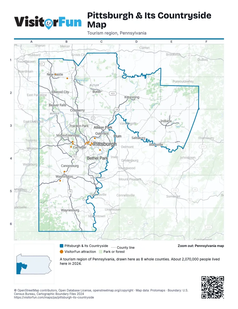
Highway index of Pittsburgh & Its Countryside
Each highway on the sheet and the grid squares it crosses.
- I-70A5, B4, B5, C5
- I-76A2, B2, B3, C3, C4
- I-79B1, B2, B3, B4, B5, B6
- I-80C1
- I-279B3, C3, C4
- I-376A1, B1, B2, B3, B4, C4
- I-579C3, C4
- US 19B3, C3, C4
- US 22A4, B4, C4, E3, E4
- US 30B4, C4
- US 40B5, C5
- US 119E2, E3, E4
- US 422A1, B1, B2, C2, D2, D3, E3, F3
- PA 8C2, C3, C4
- PA 18B3
- PA 21B6, C6
- PA 28C2, C3, C4, D2
- PA 43C5
- PA 51A2, B2, B3, C4
- PA 56D3, E3, E4
- PA 60B4
- PA 65B3, C3, C4
- PA 66D2, D3
- PA 68B3
- PA 88C5
- PA 228B3, C2, C3
- PA 286E2, E3, F2
- PA 356C2
- PA 380C3
- PA 403E3
- PA 576B3, B4
- PA 711E4
- PA 885C4
Things to do on the Pittsburgh & Its Countryside map
- Carnegie Museum of Art
- Carnegie Museum of Natural History
- Cathedral of Learning
- Drury Inn & Suites Pittsburgh Airport Settlers Ridge
- Drury Plaza Hotel Pittsburgh Downtown
- Duquesne Incline
- Hyatt Place Pittsburgh-North Shore
- Kennywood
- Lawrence County, PA
- Living Treasures Animal Park
- Pennsylvania Trolley Museum
- Phipps Conservatory and Botanical Gardens
- Pittsburgh Botanic Garden
- Pittsburgh Zoo & Aquarium
- PNC Park
- The Andy Warhol Museum
- The Mall at Robinson
- The Pittsburgh Tour Company
- The Terminal
- Washington County, PA
Places on the map
- Allison Park
- Beaver Falls
- Bethel Park
- Blairsville
- Butler
- Canonsburg
- Carnegie
- Cranberry
- Ellwood City
- Franklin Park
- Indiana
- Kittanning
- Moon Township
- New Castle
- Oakmont
- Pittsburgh
- Plum
- Saltsburg
- Washington
- Waynesburg
Next to Pittsburgh & Its Countryside
- Northeast Ohio
- Great Lakes Region map
- Laurel Highlands map
- Pennsylvania Wilds map
- The Alleghenies map
- Mountaineer Country
- Northern Panhandle
© OpenStreetMap contributors, Open Database License, openstreetmap.org/copyright · Map data: Protomaps · Boundary: U.S. Census Bureau, Cartographic Boundary Files 2024