

Pennsylvania map
Reading map
About 96,000 people live here (Census Bureau, 2024 estimate). The sheet's index lists 300 streets; River Road, Bern Street and Hampden Boulevard cross the most grid squares. Things to do inside the boundary: Reading & Berks County and Reading Public Museum.
Open the map (PDF, US Letter)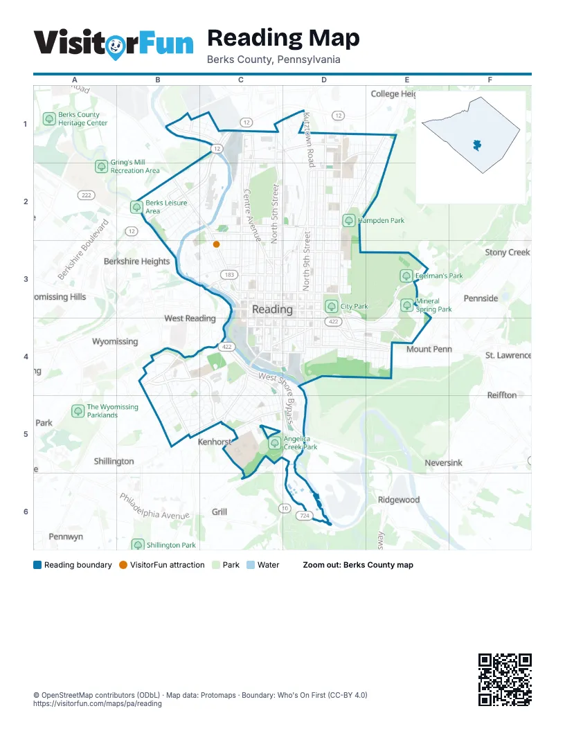
Street index of Reading
Each street on the sheet and the grid squares it crosses.
- West Shore BypassC4, D4, D5
- Warren Street BypassC1, B2, C2
- North 11th StreetD1, D2, D3
- North Front StreetC1, C2, C3
- North 5th StreetC1, C2, C3
- Centre AvenueC1, C2, C3
- Schuylkill AvenueB2, C2, C3
- Walnut StreetC3, D3
- East Lancaster AvenueC4, B5, C5
- Greenwich StreetC3, D3
- North 4th StreetC1, C2, C3
- Chestnut StreetC4, D4
- Franklin StreetC4, D4
- Penn StreetC3, D3
- Perkiomen AvenueD3, D4, E4
- Washington StreetC3, D3
- North 2nd StreetC2, C3
- Bingaman StreetC4, D4
- Lehigh StreetC1, B2, C2
- Mineral Spring RoadD4, E4
- Lackawanna StreetB2
- South 5th StreetC3, C4
- South 4th StreetC3, C4
- Laurel StreetC4, D4
- Penn AvenueC3
- Carbon StreetB2
- Bernville RoadB2
- South 2nd StreetC3, C4
- West Green StreetC3
- Butler StreetB2
- North 5th Street HighwayC1
- Howard BoulevardE4
- 5th StreetC3
- North 9th StreetD2, D3
- Hampden BoulevardE1, D2, E2, D3
- Morgantown RoadC4, C5, D5
- Spring StreetC2, D2
- Rockland StreetC1, D1, E1
- North 8th StreetD2, D3
- Windsor StreetC2, D2
- South 9th StreetD3, D4
- Museum RoadB4
- Kutztown RoadD1, D2
- West Windsor StreetC2
- South 8th StreetD3, D4
- New Holland RoadC5
- South Front StreetC3, C4
- River RoadB1, C1, B2, C2, B3, C3
- North 13th StreetD1, D2, D3
- North 6th StreetD1, D2, C3
- North 10th StreetD1, D2, D3
- East Wyomissing BoulevardB4, C4
- Hill RoadD3, E3, D4, E4
- Bern StreetC1, D1, E1, D2, E2
- Buttonwood StreetC3, D3
- North 3rd StreetC1, C2, C3
- Oley StreetC3, D3
- Cotton StreetD4, E4
- Exeter StreetC2, D2, E2
- Kenhorst BoulevardB4, B5
- Hancock BoulevardC4, C5
- Canal StreetC4, D4
- South 6th StreetC3, C4
- Parkside Drive SouthB4
- Upland AvenueC5, D5
- Richmond StreetC1, D1, E1
- South 19th StreetE4
- Clymer StreetD3, D4
- South 10th StreetD3, D4
- South 11th StreetD3, D4
- South 3rd StreetC3, C4
- South 7th StreetD4
- College AvenueD1, E1
- Hiesters LaneD1
- West Buttonwood StreetC3
- 2nd StreetC4, C5
- Denton StreetB1
- South Kenhorst BoulevardB5
- Mountain View RoadC5
- New Canal StreetC4, D4
- Cathedral StreetC1
- Lowrie StreetB1
- West Washington StreetC3
- Sofianos LaneB1
- North 12th StreetD1, D2, D3
- Moss StreetD2, D3
- Mulberry StreetD2, D3
- Duryea DriveD3, E3
- Locust StreetD2, D3
- Church StreetC2, C3
- Pear StreetC1, C2, C3
- Elm StreetC3, D3
- Alsace RoadE1, D2, E2
- East Linden StreetD1, D2, D3
- Old Wyomissing RoadB4, C4
- McKnight StreetC2, C3
- Spruce StreetC4, D4
- Clover StreetD2, D3
- Madison AvenueC1, C2, C3
- Muhlenberg StreetD4, E4
- Pike StreetC2, D2, E2
- Amity StreetC2, D2, E2
- Douglass StreetC3, D3
- Robeson StreetC2, D2
- North 14th StreetD1, D2, D3
- Lorraine RoadE1, D2, E2
- Union StreetC2, D2, E2
- Gregg AvenueC4, B5, C5
- Birch StreetD2, D3
- Saint Bernadine StreetC5, D5
- Cherry StreetC3, D3
- Court StreetC3, D3
- Perry StreetC2, D2, E2
- Brookline PlazaB4, B5, C5
- Skyline DriveE3
- Liggett AvenueC4, B5, C5
- Scott StreetB4, C4, B5
- Woodvale AvenueD4, E4
- Oak LaneD2, E2
- Arlington StreetC4, C5
- Riverfront DriveC4
- Cartech RoadC2
- Marion StreetC2, D2
- Rose StreetC1, C2, C3
- Thorn StreetC1, C2, C3
- Weiser StreetC2, C3
- Lincoln StreetC2, C3
- Hickory StreetD2
- Meade StreetB5, C5
- Eckert AvenueD4, E4
- Green StreetD3
- Miltimore StreetC2, C3
- Fairview StreetD4, E4
- Gordon StreetC2, C3
- Crestmont StreetC4, C5
- Palm StreetD1, D2
- Pershing BoulevardB4, B5
- Deharts CourtD2, D3
- Glen RoadE3, E4
- Brentwood DriveD5
- Cedar StreetD3
- Pearl StreetC3, C4
- Carroll StreetC4, C5
- Hazel AlleyC4, C5
- North 15th StreetD1, D2
- Chester StreetB2
- Park AvenueC4, C5
- Luzerne StreetB2
- Fern AvenueC4, C5
- Summit AvenueC4, C5
- Angora RoadE3
- Maple StreetD3, D4
- McClellan StreetB4, C4, B5, C5
- Columbia AvenueD1, B2
- West Douglass StreetC2, C3
- South 18th StreetE4
- Wood StreetC3, C4
- Tulpehocken StreetC3
- Bartlett StreetC4, C5
- Carpenter StreetC3, C4
- Olive StreetD1, D2
- West Oley StreetC3
- Berkley RoadB1, C1
- Nicolls StreetD2, D3
- South StreetD4
- Downing StreetB1, C1
- Blair AvenueB2, C2, B3
- Minor StreetD4
- Schlegel Park DriveC4
- Division StreetC3, B5, C5
- Ritter StreetC2, C3
- Clarion StreetB2
- Wunder StreetD4
- West Greenwich StreetC3
- Orange StreetD3, D4
- North Mill StreetD2
- Clinton StreetB2, C3
- Mercer StreetB2
- Orchard RoadB4
- South 12th StreetD4
- South 17th StreetE4
- Farr RoadB4, B5
- Grace StreetC5
- Funston AvenueB5
- Bell AlleyC4, D4
- Reed StreetD3
- Queens CourtE3, E4
- Greenway TerraceC5
- Belvedere AvenueC5, D5
- Highland StreetE4
- South 16th StreetD4
- Mill StreetD2
- North 16th StreetE1, E2
- Warren StreetB2, C2
- Sauls CourtD3
- Strong AlleyD4
- Alton AvenueD1
- South 13th StreetD4
- Brookline StreetC4, C5
- Haak StreetD4, E4
- Avenue BB2, C2
- Hessian RoadE3, E4
- Joan TerraceB4, C4
- Shearer RoadE3
- Margaret StreetB4, B5
- Noble StreetC5
- Ecks CourtD3
- South 17 1/2 StreetE4
- Wayne StreetB2
- Berks StreetC1, D1, E1
- North Birch StreetD1, D2
- Steuben RoadE3, E4
- Fairmont AvenueC1, D1
- Logan StreetB5
- Northmont BoulevardD1
- Pine StreetC4, D4
- Avenue AB2, C2
- Constitution BoulevardD3
- Culvert StreetD4
- West Spring StreetC2
- Industrial Collector RouteC2
- Mc Arthur AvenueB5
- Heckmans CourtD3
- Delta AvenueC1, D1
- Monroe StreetB2
- Market PlaceD2, D3
- Berkshire DriveC1, B2
- South 15th StreetD4
- Elder StreetE1
- Clifton AvenueB5, C5
- Newport AvenueB5
- Columbus DriveD3
- West Robeson StreetC2
- Eisenbrown StreetC3
- Patton StreetB4, C4
- Evergreen RoadB4
- Orrton AvenueC5, D5
- South 14th StreetD4
- Spring Garden StreetD4
- Lombard StreetD3
- Poplar StreetD3
- West Perry StreetC2
- Neversink Mountain RoadE4
- Prospect AvenueD4, C5
- High StreetB1, C1
- Rose Garden RoadD3
- Holly RoadE4
- Chapel TerraceD4
- Neversink StreetD4
- Gilbert StreetD3
- Alleghany AvenueB2
- Rambo AlleyD4
- Bruckman AvenueD1
- Crescent AvenueC1, D1
- Rose Virginia RoadB4
- Market AlleyC4
- Woodward StreetC3
- Lemon StreetD4
- Barberry RoadB4
- Nail AlleyD3
- Summitchase DriveB4, C4
- Farr PlaceB4, B5
- Weimer StreetD4
- Hazel StreetC4, D4, D5
- Veronica ParkwayC5
- Fehrs CourtD4
- Plum StreetD4
- Over Glen RoadE3, E4
- Willow StreetC4, D4
- Clover AlleyD3
- Pansy StreetC5
- Spuhler DriveE3
- William LaneD1, D2
- Allegheny AvenueB2
- Colston StreetC1
- Durham StreetB1, C1
- Fremont AvenueD1
- Hoffer AvenueD1
- Gerry StreetC5
- Trooper RoadE3
- South 18 1/2 StreetE4
- Burnside AvenueB4, B5
- Green TerraceC3
- Greenview AvenueB2, C2
- Little Cedar StreetD2, D3
- Sheridan StreetB5
- Forrest StreetD4, E4
- Gateway DriveC3
- Ivy StreetC5
- Woodbine StreetC5
- Johnson StreetC3
- Division AlleyD4
- Peach StreetD4
- Raymond AvenueD1
- South 16 1/2 StreetE4
- North Carroll StreetC4
- Garden LaneB4
- South 14 1/2 StreetD4
- West Cartech RoadC1, C2
- Angelica StreetC5
Things to do on the Reading map
Places on the map
- 10th & South Playground
- 10th and Green Elementary School
- 10th and Penn Elementary School
- 11th and Pike Playground
- 12th and Marion Elementary School
- 13th and Union Elementary School
- 16th and Haak Elementary School
- 3rd and Spruce Park
- 3rd and Spruce Recreation Center
- 4th and Cherry Garage
- Albert Boscov Plaza Garage
- Albright College
- Alvernia University
- Amanda E. Stout Elementary School
- Angelica Creek Park
- Baer Park
- Barbey's Playground
- BARTA Park-n-Transit Garage
- BARTA Transportation Center
- Berks Catholic High School
- Charles Evans Cemetery
- City Park
- Dengler Hill
- Egelman's Park
- Fritz Island
- Hampden Park
- Haven Behavioral Hospital Of Eastern Pennsylvania
- Mineral Spring Park
- Museum Arboretum
- Pendora Park
- Reading Senior High School
- Riverfront Park
- Schlegel Park
- St. Mary's Cemetery
- St. Peter's Catholic Cemetery
- Stonecliffe Recreation Area
Next to Reading
- Berkshire Heights
- College Heights
- Grill
- Kenhorst
- Mount Penn
- Neversink
- Pennside
- Pennwyn
- Reiffton
- Ridgewood
- Shillington
- St. Lawrence
- Stony Creek Mills
- West Reading
- Wyomissing map
- Wyomissing Hills
© OpenStreetMap contributors, Open Database License, openstreetmap.org/copyright · Map data: Protomaps · Boundary: Who's On First (CC-BY 4.0); U.S. Census Bureau















