

Pennsylvania map
Silver Spring Township map
About 21,465 people live here (Census Bureau, 2024 estimate). The sheet's index lists 300 streets; West Trindle Road, North Locust Point Road and Sample Bridge Road cross the most grid squares. Things to do inside the boundary: Cumberland Valley.
Open the map (PDF, US Letter)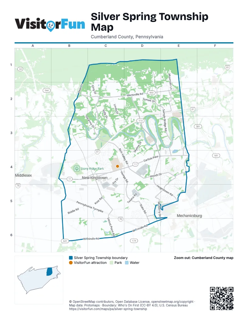
Street index of Silver Spring Township
Each street on the sheet and the grid squares it crosses.
- Pennsylvania TurnpikeB5, C5, C6, D6
- American Legion Memorial HighwayD2, E2, C3, D3
- Carlisle PikeB4, C4, D4, E4
- West Trindle RoadE5, B6, C6, D6, E6
- New Willow Mill RoadD2, D3
- Conodoguinet ParkwayD3, D4
- Conoduguinet RoadD2, D3
- Wertzville RoadB2, C2, D2, E2
- Hogestown RoadD4, D5, E5
- North Locust Point RoadB3, B4, C4, C5, C6
- Sample Bridge RoadD1, D2, E2, E3, E4
- Rich Valley RoadC2, C3, C4, D4
- Woods DriveD4, E4
- Mulberry DriveE4, D5, E5, D6
- State RoadD5, D6
- Hempt RoadC4, D4, D5
- Beard RoadE2
- West Main StreetB4, C4
- Silver Spring RoadE4
- East Main StreetC4
- Silver Spring Square RoadE3, E4
- Bare RoadD5, D6
- Farmers StreetC4
- Sinclair RoadD6
- South Locust Point RoadC6
- Ridge Hill RoadC3, B4, C4
- Texaco RoadD4, C5, D5
- Willow Mill Park RoadC3, D3
- Kost RoadB4, B5, C5
- Fry DriveC4, D4, C5
- Konhaus RoadC5, D5, C6, D6
- Millers Gap RoadC1, D1, D2
- Bent Creek BoulevardD3
- Deer LaneB1, C1, B2
- Old Willow Mill RoadD2, D3, D4
- Timber RoadC5, C6
- Stillmeadows LaneE2
- Kelly DriveC2, C3
- Old Stonehouse Road NorthB5, B6
- Leibys TrailB4
- Glendale DriveC1, C2
- Pleasant Grove RoadC2, D2, D3
- Skyline DriveD3, D4
- Stone Run DriveE4, E5
- Green Ridge RoadC3, D3
- Warm Sunday WayE4
- Bernheisel Bridge RoadB4
- Valley View DriveB3, C3
- Mountain LaneE1, E2
- Appalachian DriveB4, B5
- Biddle RoadB5
- Harpers Ferry WayC3, C4
- Sherwood DriveB2, C2
- Linda DriveC2, C3
- Beechcliff DriveC3
- Carmella DriveD4, E4
- Balfour DriveE3
- Bali Hai RoadE2, E3
- Grayhawk Way SouthD4
- Cumberland Estate DriveC4
- Pleasant View DriveD5, E5
- Longwood DriveD5
- Millfording RoadE3
- Foxanna DriveB2, B3, C3
- Commerce DriveD4
- Georgetown RoadD3
- Presidents DriveD5
- Line RoadE4
- Sunset DriveD2
- Dewalt DriveD3
- High Ridge TrailD2
- Longview DriveE4, E5
- Silver CircleC4
- Bellavista DriveC4, D4
- Honeysuckle DriveE5
- King DriveC2
- Sterling ParkwayD4, E4
- Green Hill RoadB3
- Monarch LaneE4, E5
- Mayberry LaneE5
- Bethpage DriveE3
- Hillside RoadC4
- Edris LaneE4, E5
- White Oak BoulevardD5, E5
- Homestead LaneD1, D2
- Willow Lake DriveC1, C2
- Hamlet CircleD4
- Keystone DriveD2
- Creek RoadC3, D3, E3
- Bourbon Red DriveD5
- Danbury DriveD5, D6
- River Queen CourtB3, C3
- Southwatch LaneC3, C4, D4
- Winding Creek BoulevardD3
- Pamela DriveC4
- Truffle Glen RoadD2
- Hoke Farm WayE4
- Dapp LaneC4
- Shelduck LaneE3
- Northwatch LaneC3, C4
- Bayberry DriveE5
- Gunpowder RoadE3
- Cloudless Sky DriveE4
- Keswick DriveD5
- Sycamore DriveD5, E5
- Tavern House HillE4
- Oak AvenueD2
- Republic WayD6
- Grayhawk Way NorthD4
- Ashburg DriveC4
- Waterford DriveC4
- Foxwood BoulevardE4, E5
- Bridgeport DriveE3
- Independence WayD5
- Pine Hill AvenueD2
- Walden WayE4
- Stallion StreetE4
- Penns Way RoadC3, C4
- Lilac DriveE5
- Alexandria CourtC4
- Greenspring DriveD5, D6
- Royal Palm DriveD5
- Coffman's Point DriveE3
- Springdale WayD4
- Maple DriveE4
- Dunbar DriveE3
- Presbyterian DriveE4
- Louis ParkwayB4
- Dauphin DriveC4
- Shaw StreetE4
- Teal RoadD4
- Rife DriveE5
- Coopers Hawk DriveD4
- Cumberland DriveC4
- Silver Crown DriveE2
- Irongate CourtE4, E5
- Notting Hill Estate LaneD2
- Bittersweet LaneE4, E5
- Raspberry DriveE5
- Natures CrossingsD1, E1
- Scenery DriveE3
- Creek Bank DriveD3
- Field Stone RoadC4
- Wild Rose LaneD2, E2
- Village RoadD4
- Fry RoadC4, D4, D5
- Blue Mountain VistaD3
- Simon CourtD4
- Colonial DriveD5, D6
- Long LaneC5, D5
- Westfields DriveD5, D6
- Wintergreen DriveE4
- Northview DriveD5
- James Madison DriveD5
- Founders WayD5
- Cathy WayC4
- White Birch LaneD2
- Nottingham DriveB4, C4
- Congress DriveD5
- Surrey LaneE5
- Northfield WayC2
- North Madder DriveD5
- Tanglewood DriveE3
- Loyal DriveD5, D6
- Woodstock CourtB3, C4
- West Willow TerraceD3
- Vogelsong LaneC2
- Margaret DriveD4
- South Madder DriveD5
- Summer LaneE4
- Kensington PlaceD6
- Stratford LaneE3
- Hummingbird LaneB6
- York CircleE5
- Phico DriveD4, E4
- Ridge BoulevardC4
- Greenbriar DriveE3
- Ridgeway DriveD5
- Houston DriveD2, E2
- Valor DriveD5, D6
- North RoadE5
- Cardamon DriveD5
- Rockledge DriveD4, D5
- Clover LaneD5
- Meadow Creek LaneE4
- General DriveD6
- Brenneman CircleC5, D5
- Access RoadD5
- Artcraft DriveC6, D6
- Holly LaneD4, E4, D5
- Emerson WayE4
- Marble StreetD2
- Cedar RoadD4
- Hidden Meadow DriveD3, E3
- Bryant StreetE4
- Old Dirt RoadD2
- Hunt PlaceE4
- Locust CircleD5
- East Willow TerraceD3
- Braxton RoadD3, E3
- Dubs CircleE2
- Rycroft RoadD2, E2
- Putnam WayE4
- Allegiance DriveD6
- Doughten RoadC4
- Chruch DriveD5
- Turmeric DriveD5
- Ginger DriveD5, E5
- Colonial CourtD3
- Fallowfield DriveD5
- Springdale CourtD4, E4
- Redco DriveD1, E1
- Vo-Tech RoadD3
- Humer DriveD2
- Brook Meadow DriveD5
- Cicada DriveE4
- Penny LaneD2
- South Locust LaneD2
- Vicksburg CourtC4
- Easterly DriveD6
- Birch StreetE4
- Barnhart CircleE2, E3
- South RoadE5
- Torrey Pines DriveE3
- Hickory RoadB5
- Meadowland DriveE4
- Oak LaneD2
- Red Fox LaneE2
- Silver DriveE4
- Freedom CourtC3
- Sutherland WayE4
- Butternut LaneD5, E5
- Wheatland DriveE2
- Burwick DriveD5
- Shoemaker LaneD2
- Sporting Green DriveE3, D4, E4
- Winchester CourtC4
- Avery WayE4
- Warwick CircleC4, C5
- Amity LaneD2
- Rich Valley ExtensionC3
- Spring View CourtE5
- Brandywine DriveE3
- Pheasant StreetD6
- Reserve LaneD4
- Tawny AlleyE4
- Deerburn CourtD3, E3
- Conifer LaneE2
- Bull Run CourtC4
- Oyster Bay DriveE3
- Stone Barn RoadE4
- White Birch AvenueD2
- Ellington RoadE4
- North Locust LaneD2
- Peter RoadD3, D4
- Johns DriveD2
- Poplar DriveE4
- Deerfield RoadC4
- Sorbie LaneE3
- West Willow Terrace DriveD3
- Fieldcrest DriveD5
- Sugar Maple WayD4
- Winslow AlleyE4
- Bobolink CourtE3
- Clouser RoadD6
- Folsom AlleyE4
- Badden Powell LaneD3
- Lexington DriveE3
- Orange AlleyE4
- Honey Locust DriveD3
- Legend LaneC4
- West Hill DriveE2, E3
- Flowers DriveD3
- Natures CrossingD1
- Sterling Glen WayD4
- Fawn Leap WayE4
- Kestrel DriveD4
- Glen Eagle DriveE3
- Walnut LaneE4
- Doe RoadD1
- Round Top CourtC3
- Heritage CourtD3
- Sportsman RoadD1
- Cottage CourtE5
- Liberty CourtD3
- Eleanor DriveC4
- Foxfield CourtE3
- Nancy LaneD1
- Kerry CourtD5
- Cromwell CourtD6
- Carothers CircleC3
- Jensens AlleyE4
- Myers CircleB6
- Nita CourtD2
- Millers Pointe LaneD2
- Lincoln StreetC2
- Victor LaneD2
- Greenwood DriveE4
- Red Bud DriveD3
- Tall Oak DriveD5
Places on the map
- ABC West Lanes
- Adventure Zone Park
- Aldi
- Alfredo's
- AmeriChoice Credit Union
- Appalachian Brewing Company
- Appalachian Harley-Davidson
- Arby's
- Bobby Rahal Field
- Bombay Bazzar
- Carmax
- Chick-fil-A
- Chili's
- Climbnasium
- Costco
- Cumberland Perry Vo-Tec
- Cumberland Valley Educational Park
- Cumberland Valley High School
- Cumberland Valley HS Stadium
- CVS Pharmacy
- Deitch Airport
- GEODIS Supply Chain Optimization
- Hidden Creek Park
- Locust Point Quarry
- Mountain View Middle School
- New Kingstown
- New Kingstown Post Office
- Paul Walters Memorial Park
- Pleasant View Park
- Potteiger Park
- Silver Spring Commons
- Silver Spring Quarry
- Silver Spring Square
- Stony Ridge Park
- Terra Park
- Trindle Spring Cemetery
- Vincent DiFilippo Nature Preserve
- Walmart Supercenter
- Willow Mill Park
- Winding Creek Elementary School
Next to Silver Spring Township
- Mechanicsburg
- Middlesex
© OpenStreetMap contributors, Open Database License, openstreetmap.org/copyright · Map data: Protomaps · Boundary: Who's On First (CC-BY 4.0); U.S. Census Bureau















