

Pennsylvania map
Susquehanna Township map
About 28,214 people live here (Census Bureau, 2024 estimate). The sheet's index lists 300 streets; North Progress Avenue, American Legion Memorial Highway and North Front Street cross the most grid squares. Things to do inside the boundary: National Civil War Museum.
Open the map (PDF, US Letter)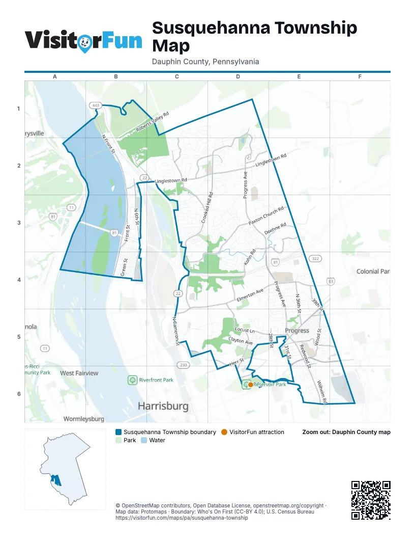
Street index of Susquehanna Township
Each street on the sheet and the grid squares it crosses.
- American Legion Memorial HighwayB3, E3, C4, D4, E4
- George N. Wade Memorial BridgeA3, B3
- North Cameron StreetC4, C5
- George N Wade BridgeA3, B3
- North Progress AvenueD1, D2, D3, D4, E4, E5
- North Front StreetB1, B2, B3, B4
- Linglestown RoadB2, C2, D2, E2
- Union Deposit RoadE5, F5, E6
- Walnut StreetE4, E5, D6
- South Progress AvenueE5, E6
- Herr StreetD5, E5, D6
- Mountainview RoadB2, C2
- Arsenal BoulevardC5, D5
- Front StreetB3, B4
- Jonestown RoadE4
- Parkway BoulevardE6
- Market StreetE6
- South 28th StreetE6
- Market Street RoadE6
- Maclay StreetC5
- Industrial RoadB2
- Elmerton AvenueC4, D4, E4, C5
- Locust LaneD5, E5
- Canby StreetD5, E5, E6
- Crooked Hill RoadD2, C3, D3, C4
- Paxton Church RoadD3, E3, C4, D4
- North 6th StreetB2, B3, B4
- Kohn RoadD3, D4
- Fargreen RoadC2, C3
- Schoolhouse LaneE5, F5
- Continental DriveD1, D2
- Wood StreetE5
- Deer Path RoadC2, D2
- North 36th StreetE4, E5
- Interstate DriveD3, E3, E4
- Edgemont RoadD5
- North Galen RoadC2
- State Farm RoadD4, D5
- Ailanthus LaneD2
- North 39th StreetE4
- Commerce DriveE3
- North 28th StreetE5
- Lexington StreetE5
- Parkway DriveD5, D6
- South 39th StreetE4, E5
- Green StreetB3, B4
- North 2nd StreetB2, B3, B4
- Ridgeway RoadD4, E4
- Roberts Valley RoadB1, C1, B2
- Bradley DriveD2, D3
- Cloverfield RoadE4, E5
- Redwood StreetE5, E6
- North 3rd StreetB2, B3, B4
- Oakhurst BoulevardD1, D2, E2
- Sycamore DriveD4, C5, D5
- Appletree RoadC2, D2, C3
- Mountain View RoadC1, D1, C2
- Ionoff RoadD3
- George StreetD5, E5
- Blue Ridge RoadC2
- Valley RoadD4, E4
- Laurelwood DriveC2
- Jonagold DriveD3
- Wilhelm RoadE6
- Wandering WayC3
- Brookfield RoadD5, E5
- North 4th StreetB3, B4
- Chestnut AvenueE5
- Saybrook LaneC2
- Clayton AvenueD5
- Cherrington DriveD3
- Dogwood DriveC3, C5, D5
- Garrison AvenueD2
- Doehne RoadD3, E3
- Beaufort Hunt DriveD2
- Susquehanna AlleyB3, B4
- Vartan WayD3
- Chatham WayD1, D2
- Laurel Glen DriveC2, D2
- Hillcrest RoadE4
- Walker Mill RoadD4
- Centerfield RoadE5
- Kramer StreetE5, F5
- Aspen WayD4
- Boas StreetD5, D6, E6
- Maple StreetE5
- Altavista AvenueE5, E6
- Stanley RoadC5, D5
- Pebble CourtD3
- Shell StreetE5
- Montfort DriveC3
- Elmwood DriveD2, D3
- Elm StreetE5
- National Civil War Museum DriveD6
- North 26th StreetD5
- Orchard Hill RoadC2, C3
- Brindle DriveE4
- Logan AlleyB3, B4
- Bamburger RoadC4, D4
- North Circle DriveC5
- Penn StreetB3, B4
- Maple Shade DriveC2, D2
- Shutt Mill RoadC3, D3, D4
- Pheasant Hill RoadD2
- Kirkwood RoadC2, C3
- Pelham RoadC3
- Fulton AvenueB3, B4
- Catherine StreetD5, E5
- Laurel Ridge DriveD2
- Market PlaceE3
- Mitchell RoadC2, C3
- Latshmere DriveE5, E6
- Poplar StreetE5
- South 31st StreetE5
- Reichert RoadD3
- Shield StreetE5, E6
- Hawthorne DriveD2
- Colonial RoadE4
- Wayne AvenueD5
- Katie CourtF6
- Fox Hunt LaneC2
- Fort Hunter RoadB1
- Goose Valley RoadD4, E4
- Highpointe DriveC3
- South 32nd StreetE5, E6
- Tall Pine DriveC1, D1
- Sauers RoadD2, D3
- Rock Ledge RoadC1, C2
- Edwin AvenueB4
- Sunflower DriveD3
- Apollo AvenueC3
- Countryside DriveC2
- Wakefield RoadE5
- North View LaneD2
- Fishburn StreetE5
- Sandra AvenueE6
- Daybreak CircleD4
- Ash StreetE5
- Christopher PlaceD3
- Mountainrise DriveC1, D1, D2
- North 21st StreetD5
- Montrose StreetB4
- North 30th StreetE5
- Durham RoadB3
- Sky View CircleC3
- McNaughton DriveC2
- Penbrook AvenueE5
- Alessandro BoulevardE3
- Gravel RoadD2
- Thea DriveD3
- North 19th StreetD6
- Clinton RoadE4, E5
- North 22nd StreetD5, D6
- Trinity StreetD4, E4
- Mayflower AlleyE5
- Reserve WayD3, D4
- Custer DriveC2
- Pierce StreetD5
- Brandywine DriveD3
- Oliver DriveE5
- Pebble Brook LaneC3
- Eric DriveC2
- Magnolia TerraceD3, E3
- Pilgrim AlleyE5
- Long AlleyB3
- Park StreetE5
- Fox StreetE5
- Larry DriveE5, E6
- Evergreen RoadD5
- Citation DriveE2, E3
- Red RoadB1, B2
- Martina DriveD4
- Brookside DriveE4
- Canterbury RoadE4
- Sunrise StreetE5
- Estherton AvenueB3
- Franklin AvenueD5
- North 24th StreetD5
- Darby RoadE5, F5
- Oakwood DriveD2
- Rivington TerraceD6
- Vernon StreetE5
- North 34th StreetE5
- Bergner StreetB4
- Columbia AvenueD5
- Woodridge DriveD3
- Chevy Chase DriveD2
- Oxford AvenueD5
- River StreetB3, B4
- Park RoadE6
- Sturbridge DriveD2
- Tuscarora StreetB2
- Old Township RoadF6
- Short StreetE5
- Thornton RoadD5
- Laurel DriveC2
- Linn StreetE5
- Nationwide DriveD4, E4
- Belair RoadE4
- Saddle Ridge DriveD1, D2
- Fawn CourtC2, D2
- Tudor DriveE4
- Cypress DriveD4
- Buck Run LaneC2
- Andrea AvenueD4, E4
- North 38th StreetE4, E5
- Caughey DriveE4
- Glenside DriveD5
- Oak StreetE5
- Beaufort StreetE6, F6
- Kota AvenueD2
- Driftstone DriveD3
- Sara Lindmuth DriveE4
- Vineland AvenueD5
- Enclave DriveD4
- Great Oak LaneC2
- Forster StreetD6
- North 25th StreetD5
- Earle StreetE5
- Holly DriveC1, C2
- Lucknow RoadB3
- Lakeside DriveC2
- Belvedere StreetE4, E5
- Birch StreetD5, E5
- Smokehouse LaneC3
- Regency CircleC3
- Athena AvenueC3
- Technology Park DriveC5
- North 27th StreetD5
- South 30th StreetE5
- Strawberry StreetE5
- Blackberry AvenueE5
- Brittany BoulevardE4
- Dewberry AvenueE5
- Pond StreetE5
- Pine StreetE5
- Dogwood RoadC2, D2
- Crest RoadE4, E5
- Fawn Ridge NorthD4
- Gateway DriveD3
- Kaby StreetB2, B3
- Round Hill RoadC3
- Birchwood CircleD3
- Oaklea RoadC2, D2
- Wild Strawberry LaneE6
- Sheffield LaneC3
- Concord CircleD3
- Vartan CourtD3
- Old Post RoadD2
- Logan StreetB4
- Lori Lane CircleC3
- Powers AvenueF5, F6
- Mount Vernon CircleD2
- Hunters Ridge DriveD2
- Brytton LaneC3
- Bonnyview RoadE5
- Penrose StreetE5
- Vesta LaneC3
- Alden StreetE5, E6
- North Scenic RoadD4, E4
- Pine Ridge RoadC2
- Azalea DriveC5
- Beaucrest StreetE6
- Bonnybrook RoadE5
- Hetrick DriveE5
- Peach AlleyE5
- Braeburn LaneD3
- Capital DriveD4
- Autumn ChaseC2, D2
- Apple AvenueE5
- Cotswold DriveC3
- South Circle DriveC5
- Saint Clair CourtD3
- Batesfield RoadE5
- Kenton LaneC3
- Cranberry CircleD3
- Buxton RoadD3
- Meadow LaneE5
- Rock Fall RoadD2
- Timber View DriveD2
- Corey RoadF6
- North 32nd StreetE5
- Waverly Woods DriveD1
- Herbert Hoover DriveC2, D2
- Miller LaneB2
- Bolinger RoadE5
- Park View DriveD1
- Jericho DriveD2
- Holly Hills DriveD2
- Wood AlleyE5
- Travis WayD4
- Lescure AvenueE6
- Fenwick DriveC3
- Hiddenwood DriveC2
- Newtown DriveD2
- Cumberland AvenueD2
- Beech StreetD4
- Parkway RoadB3
- Gorse DriveD4
- Kindred PlaceD1, D2
Things to do on the Susquehanna Township map
Places on the map
- American Automobile Association
- Apple Creek Park
- Arby's
- Best Western
- Blue Ridge Park
- Boyd Park
- Burger King
- Calvary Independent Church
- Capital Area Head Start
- Centennial Barn
- Christian McNaughton Memorial Park
- Citizens Bank
- Crown Point Park
- CVS Pharmacy
- Dauphin County Community Gardens
- DaVita Dialysis
- Dental Care of Harrisburg
- Dick Wolfe's Garage
- Dollar General
- Dr. George M. Kosco III, D.O & Associates, P.C.
- East Harrisburg Cemetery
- Edgemont Community Park
- Fine Wine & Good Spirits
- First Alliance Church
- First Assembly of God
- First National Bank
- Fort Hunter Mansion and Park
- Fulton Bank
- Harrisburg Post Office
- Logan Farm Park
- McCormick Island
- Progress
- Reservoir Park
- Shutt Mill Park
- Susquehanna SCCA Rallycross
- Susquehanna Township Middle School
- The UPS Store
- Union Square
- Veteran's Park
Next to Susquehanna Township
- Colonial Park
- Enola
- Harrisburg map
- Marysville
- West Fairview
- Wormleysburg
© OpenStreetMap contributors, Open Database License, openstreetmap.org/copyright · Map data: Protomaps · Boundary: Who's On First (CC-BY 4.0); U.S. Census Bureau















