

Rhode Island map
Bristol map
About 22,023 people live here (Census Bureau, 2024 estimate). The sheet's index lists 300 streets; Metacom Avenue, Hope Street and Poppasquash Road cross the most grid squares. Things to do inside the boundary: Blithewold Mansion, Gardens & Arboretum, Coggeshall Farm Museum and Herreshoff Marine Museum.
Open the map (PDF, US Letter)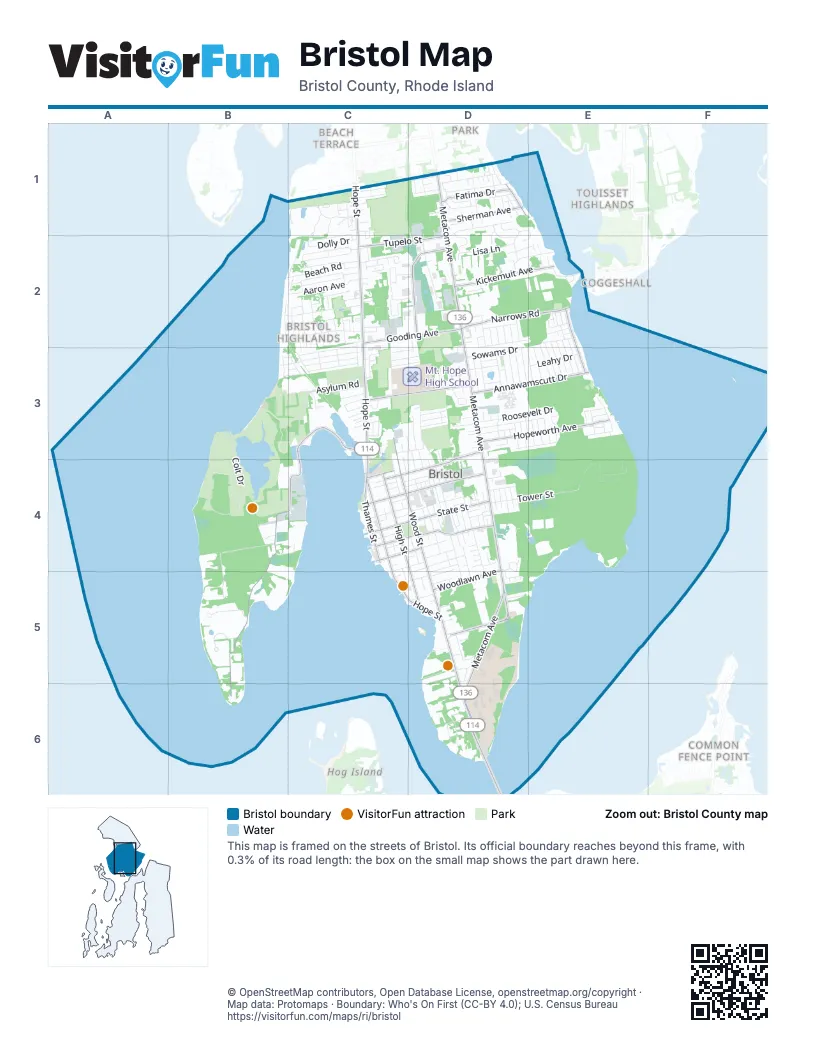
Street index of Bristol
Each street on the sheet and the grid squares it crosses.
- Metacom AvenueD1, D2, D3, D4, D5, D6
- Hope StreetC1, C2, C3, C4, C5, D5
- Mount Hope BridgeD6
- Ferry RoadD5, D6
- Wood StreetC3, C4, D4, D5
- Bayview AvenueD3, C4, D4
- Gooding AvenueC2, D2
- Tupelo StreetC2, D2
- Poppasquash RoadC3, B4, C4, B5, B6
- High StreetC4, D4, D5
- Hopeworth AvenueD3, E3
- State StreetC4, D4
- Franklin StreetC4, D4
- Annawamscutt DriveD3, E3
- Broadcommon RoadD2
- Narrows RoadD2, E2
- Chestnut StreetC3, D3
- Griswold AvenueD5
- Kickemuit AvenueD2, E2
- Thames StreetC4
- Mount Hope AvenueD4
- Sherman AvenueD1
- Woodlawn AvenueD4, D5
- Fatima DriveD1
- King Phillip AvenueE2, E3
- Constitution StreetC4, D4
- Church StreetC4, D4
- Everett StreetD1
- Washington StreetC4
- Colt DriveB3, B4
- Tower StreetD4, E4
- Asylum RoadC3
- Clam Shell RoadB4, B5
- Colt State ParkC3
- Dewolf AvenueD4, D5
- Fales RoadB3, C3
- Roosevelt DriveD3, E3
- Beach RoadB2, C2
- Sherry AvenueD3, D4
- Gibson RoadB2, C2
- Aaron AvenueB2, C2
- Mulberry RoadB2, C2
- Ballou BoulevardD2
- Michael DriveD1, D2
- River StreetD3, E3
- Peck AvenueC2
- Franca DriveD1
- Lisa LaneD2
- Greylock RoadC2, C3
- Sullivan LaneC2
- Sowams DriveD3
- Tobin LaneC2
- Naomi StreetC2, C3
- Butterworth AvenueD1
- Leahy DriveD3, E3
- Brook Farm DriveC2
- North Farm DriveC1
- Patricia Ann DriveC1, C2
- Birchwood DriveD1, D2
- Kingswood RoadC3
- Berry LaneD3, E3
- Perry StreetD2, C3, D3
- Smith StreetD2, E2
- Courageous CircleB5
- Duffield RoadC3
- Shore RoadB2, C2, C3
- Ursula DriveD2
- Dolly DriveC2
- Highland RoadC2
- Addy DriveD2
- Foxhill AvenueD4, D5
- Buttonwood StreetD4
- Seal Island RoadD4, D5
- Coggeshall Farm RoadB4, C4
- Beach LaneC1
- Monkey Wrench LaneD6
- Walter Burke DriveB3, C3
- Magnolia StreetD4
- Baptist RoadC3
- Harrison StreetE2
- Bradford StreetC4, D4
- Cliff DriveC2
- Beachmount RoadC2
- North LaneC1
- Reliance DriveB5
- Monroe AvenueC3, C4
- Surf DriveC2
- Vally RoadB4
- Charles StreetD4
- Hamlet CourtC2
- Jane LaneD3
- Francesca LaneD3
- Ridge RoadC2
- Viking DriveE3
- Saint Mary StreetC3
- Belvedere DriveE2, E3
- Sefton DriveE2, E3
- Fulton Campus WayD6
- Opechee DriveE2, E3
- Lafayette DriveE2, E3
- Old Ferry RoadD6
- Cedar DriveE2, E3
- Academy AvenueD3
- Dixon AvenueC3, D3
- Basswood DriveE2, E3
- Fernwood RoadD3
- Rosedale DriveD3
- Wapping DriveD3, E3
- Primrose RoadD3
- Charlotte DriveD3
- Roma StreetC4, D4
- Sweeney LaneD3
- Greenway DriveD3
- Monterey DriveD3
- Tilbury DriveE2, E3
- Bristol Woods DriveC2, D2
- Leila Jean DriveD3
- San Jose DriveD1
- Weetamoe Farm DriveD4, D5
- Union StreetC4, D4, C5
- Varnum AvenueD3
- Casey DriveD1, D2
- Antony AvenueD4, D5
- Sunrise DriveE2
- Oliver StreetC4
- Burton StreetC5, D5
- San Miguel DriveD1
- Richmond StreetD4
- Peckham PlaceC2
- Cole StreetD4, D5
- Hawthorne AvenueD1
- Harbor View AvenueC3
- Betsy DriveD1, D2
- Robin DriveD3
- Annawanscutt Boat Launch Access RoadE3
- Terrace DriveC1
- Deer Run RoadC1, C2
- Elmwood DriveC1
- Peckham DriveC2, D2
- Sea Breeze LaneC1
- Coggeshall AvenueE2
- Dartmouth StreetC3, D3
- Sandra DriveC2
- Forest RoadC2
- Portside RoadB4, C4
- Clipper WayE3
- Van Wickle LaneD5
- Low LaneD6
- Saint Michael AvenueC3
- Jennifer DriveD2
- Massasoit AvenueD4
- Saint Anna AvenueD1
- Greg DriveD1
- Jameson DriveD1
- Collins StreetD4, D5
- Juniper CourtD2, E2
- Sunset RoadC2, C3
- Catherine StreetD4
- Lugent LaneD3
- Saint Elizabeth RoadC3
- Dreadnaught AvenueC2
- Peter RoadD2, D3
- Walley StreetD5
- Sandy LaneD1, E1, D2, E2
- Saint Elizabeth StreetC4, D4
- Sachem RoadD1
- Pokanoket StreetE4
- Dimond AvenueC3
- Wall StreetD4
- Justin StreetD1
- Hydraulion AvenueC2
- Anawan AvenueD1
- Evelyn DriveE3
- Westwood RoadC2, C3
- Acacia RoadC2
- Clifton RoadC3
- Platt StreetE2
- Jessica DriveD2
- Everready AvenueC2
- Ambrose DriveD5
- Center StreetD4
- Manor DriveC3
- Prospect StreetD4
- Andrews CourtC3, D3
- Waterman AvenueD3
- Goulart AvenueD4
- Sunnyside AvenueC3
- San Juan DriveD1
- Loring RoadC3
- Brookwood RoadB3
- Valley DriveC3
- Church Cove RoadD5
- Lea DriveC2
- Sousa StreetD2
- Stephen DriveD1, D2
- Windward LaneC1, C2
- King StreetD3
- Alan DriveD3
- Ledge RoadC2
- Wendy DriveE3
- Colonial RoadC2
- Fesser AvenueD5
- Martin AvenueE3
- Thompson AvenueD3, D4
- Jenkins StreetD3
- Lang AvenueD3, E3
- Glenview DriveE3
- Russell AvenueD4
- Division StreetE2
- Manchester StreetD3, D4
- Vernon AvenueD4
- Paull StreetC3
- Hilltop StreetD4
- 3rd School StreetD4
- Vantage Point DriveC3
- Captain StreetD5
- Fort Hill RoadC3
- Roger Williams University WayD5
- Saint Theresa AvenueD1
- Defiance AvenueC2
- Karen Ann DriveD2
- Garfield AvenueD5
- Judy DriveD2
- Marie DriveD2
- Jenny LaneD3
- Wayland RoadC2
- Verndale CircleC2
- Cottage StreetD4, D5
- Congregational StreetC4, D4
- Kathy CourtD2, D3
- Court StreetC4
- Crest RoadC3
- Maywood RoadC3
- Bourne StreetC4
- Meadow LaneC2
- Byfield StreetC4
- Melrose RoadB3, C3
- Pawtucket AvenueD1
- Babbitt AvenueE3, E4
- Reservoir AvenueD4
- Fish Hawk LaneD6
- Shaws LaneD4
- Thayer StreetD1
- Doran AvenueC3, C4
- Hampden DriveD3
- Scott LaneD3
- Ansonia AvenueD4
- Etelvina CourtD1
- 1st School StreetD4
- 2nd School StreetD4
- Baker StreetC3, D3
- West Harbor RoadC4
- Donna CourtC2
- Hattie Brown LaneD3
- Clarks RowC1
- Creek LaneC3
- Herzig StreetC2
- Wales DriveC2
- Erickson LaneE3
- Normand StreetD1
- E StreetD4
- Minturn Farm RoadD4
- Paine AvenueE2
- Woodbine StreetD4
- George StreetD3, D4
- Temple RoadC3
- Congregational AvenueC3
- Cooke StreetD4
- Burke RoadD4
- Pearse AvenueD4
- Chester AvenueC2
- Adelaide AvenueC3
- Noyes AvenueC4, C5
- Plant AvenueD5
- Bliven AvenueC2
- Collier DriveD3
- Gorham PlaceC3
- Malden StreetD4
- Spinnaker LaneC1
- Mount CarmelC3
- Ruth AvenueE3
- San Francisco AvenueD1
- Tina CourtD2
- Villa AvenueE3
- Bray LaneE3
- Francine StreetD3
- Ocean View DriveC2
- Violet CourtE3
- Abilio DriveD4
- Mount AvenueD3
- Belcourt AvenueD4
- Arthur AvenueD4
- Mason AvenueD4
- Riverview AvenueD1
- Corte Reale DriveC2
- Fried StreetE2
- Sheffield AvenueC3
- Burnside StreetC5, D5
- Heritage RoadD4
- Alves StreetD3
Things to do on the Bristol map
Places on the map
- Bristol Golf Park
- Bristol Historical and Preservation Society Library
- Bristol Landing Preserve
- Bristol Marine
- Bristol Post Office
- Bristol Town Beach
- Bristol Yacht Club
- Children's Grove
- Church Street Marina
- Claire D. McIntosh Wildlife Refuge
- Colt State Park
- Ferry Hill
- Fort Hill
- Fox Hill
- Gooding Avenue
- Guiteras Park
- Haffenreffer Property
- Halfmile Hill
- Juniper Hill
- Juniper Hill Cemetery
- King Phillips Chair
- Law Library
- Leahy's Pond
- Mount Hope
- Mount Hope Farm
- Mt. Hope High School
- Naomi Street
- North Burial Ground
- Paull Park
- Perry-Tavares Farm Open Space
- regatta staging area
- Rhode Island Veteran's Home
- Roger Williams University
- RWU Library
- Saint Mary's Cemetery
- Senior Center
- Spar Island
- Tanyard Reservoir
- The Bristol Town Common
- Williams Property
Next to Bristol
- Beach Terrace
- Coggeshall
- Common Fence Point
- Laurel Park
- Touisset Highlands
© OpenStreetMap contributors, Open Database License, openstreetmap.org/copyright · Map data: Protomaps · Boundary: Who's On First (CC-BY 4.0); U.S. Census Bureau















