

Rhode Island map
Bristol County map
About 50,145 people live here (Census Bureau, 2024 estimate). The sheet's index lists 300 streets; Metacom Avenue, Poppasquash Road and Hope Street cross the most grid squares. Things to do inside the boundary: Blithewold Mansion, Gardens & Arboretum, Coggeshall Farm Museum and Haines Memorial State Park.
Open the map (PDF, US Letter)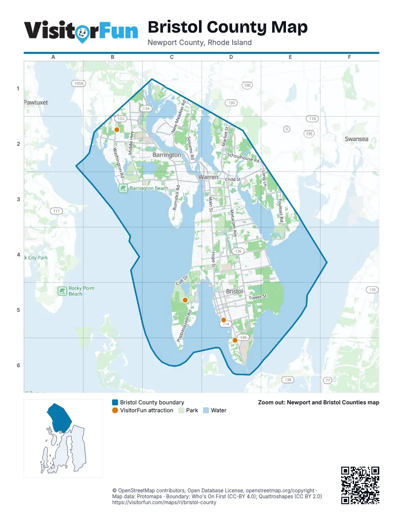
Maps inside Bristol County
2 maps inside, from the street map of Bristol County down.
Street index of Bristol County
Each street on the sheet and the grid squares it crosses.
- Metacom AvenueD2, D3, D4, D5, D6
- County RoadB1, B2, C2
- Hope StreetD2, D3, D4, D5
- Wampanoag TrailB1, C1, B2
- Market StreetD2, D3
- Child StreetD2, E2, D3
- Main StreetD2, D3
- Mount Hope BridgeD6
- Ferry RoadD5, D6
- Kickemuit RoadD2, D3
- Arlington AvenueD3
- North Main StreetC2, D2
- Willett AvenueB1
- Middle HighwayB1, B2, B3
- New Meadow RoadC1, C2
- Nayatt RoadB3, C3
- Wood StreetD3, D5
- Rumstick RoadC2, C3
- Massasoit AvenueC2, D3, D5
- Bayview AvenueE4, D5
- Gooding AvenueD4
- Tupelo StreetD4
- Federal RoadB2, C2
- Wilbur AvenueE2
- Poppasquash RoadC4, D4, C5, D5, C6
- Washington RoadB2, B3
- Sowams RoadC1, C2
- Touisset RoadE3, E4
- Franklin StreetD3, D5
- Lincoln AvenueB2, C2, D3, D5
- Schoolhouse RoadD2, E2
- Fatima DriveD3
- High StreetB2, D5
- Birch Swamp RoadD2
- State StreetD3, D5
- Hopeworth AvenueD4, E4, D5
- Long LaneE2, E3
- Water StreetD2, D3
- Annawamscutt DriveD4, E4
- Chestnut StreetD2, D4
- Church StreetB2, C2, D3, D5
- Broadcommon RoadD4
- Narrows RoadD4, E4
- Griswold AvenueD5
- Kickemuit AvenueD4, E4
- Mathewson RoadC2, C3
- Thames StreetD5
- Barton AvenueC2, E3
- Narragansett AvenueB2
- Ferry LaneC3
- Mount Hope AvenueD5
- Sherman AvenueD3
- Seymour StreetD3
- Martin AvenueC2, E4
- Vernon StreetD3
- Woodlawn AvenueD5
- Bay RoadC3, D3
- King Phillip AvenueE4
- Bay Spring AvenueB2
- Everett StreetD3
- Kent StreetC2
- Chachapacassett RoadC3
- Lamson RoadC2
- Washington StreetD3, D5
- Primrose Hill RoadB1, C1
- Constitution StreetD5
- Metropolitan Park DriveB2
- Campbell StreetD3
- Barneyville RoadC1
- Ormand DriveB1
- Colt DriveC4, C5
- Asylum RoadD3, C4, D4
- Tower StreetD5, E5
- Maple AvenueB2, C2
- Governor Bradford DriveC3
- Serpentine RoadD2, D3
- Clam Shell RoadC5
- Beach RoadC3, C4, D4
- Adams Point RoadC3
- Bradford StreetB2, D3, D5
- Upland WayB2, C2
- Colt State ParkC4
- Alfred Drowne RoadB2
- Dewolf AvenueD5
- Prospect StreetB2, D5
- Fales RoadC4, D4
- Roosevelt DriveD4, E4
- Peck AvenueB2, C4, D4
- South Lake DriveB2, B3
- Sherry AvenueD4, D5
- Gibson RoadC4, D4
- Canario DriveD3
- Aaron AvenueC4, D4
- Mulberry RoadC4, D4
- Baggy Wrinkle CoveD3
- George StreetC1, E4, D5
- Ballou BoulevardD4
- Hawthorne AvenueC3, D3
- Walnut RoadB2
- Foote StreetB2, C2
- Laurel LaneC1, D3
- Kinnicutt AvenueD2, D3
- Union StreetD2, D3, D5
- Michael DriveD4
- North Lake DriveB2
- Shore DriveB2, E3
- Mallard Cove WayC1
- River StreetD4
- Cottage StreetC2, D3, D5
- Half Mile RoadC2, C3
- Terrace DriveC3, D3
- Charles StreetC2, D5
- Franca DriveD3
- Lisa LaneD4
- Harris AvenueD3
- Broadview DriveC3
- Brittney LaneD2
- Riverside DriveC2
- Ridgeway DriveD3
- West StreetC2, D3, D5
- Greylock RoadC4, D4
- Sullivan LaneC4, D4
- Sowams DriveD4
- Tobin LaneC4, D4
- Maple RoadE3
- Highview AvenueB2, D2, D3
- Naomi StreetD4
- Great RoadB1, B2
- Butterworth AvenueD3
- Leahy DriveD4, E4
- Brook Farm DriveD4
- Meadowbrook DriveC2
- Heritage RoadC1, D5
- North Farm DriveD3
- Promenade StreetB2
- Patricia Ann DriveC4, D4
- Birchwood DriveD4
- Linden RoadC2
- Homestead AvenueB2, D3, D4
- Kingswood RoadC4, D4
- Berry LaneE4, D5, E5
- College LaneB1
- Perry StreetD4, D5
- Houghton StreetB2
- Whipple AvenueB2, C2
- Roffee StreetB2, C2
- Smith StreetD4, E4
- Courageous CircleC5
- Overhill RoadD3
- Duffield RoadC4, D4
- Shore RoadC4
- Pinetop RoadB1, C1
- Fern DriveE2, D3, E3
- Opechee DriveC2, E4
- Ursula DriveD4
- Dolly DriveC4, D4
- Highland RoadC4
- Addy DriveD4
- Foxhill AvenueD5
- North LaneB2, D3
- 3rd StreetB2, D3
- Buttonwood StreetD5
- Seal Island RoadD5
- Haines Park RoadB2
- Coggeshall Farm RoadC5
- Beach LaneC3, D3, C4
- Old Chimney RoadC2
- Monkey Wrench LaneD6
- King StreetD3, D4
- Walter Burke DriveC4
- Magnolia StreetD5
- Cole StreetD3, D5
- Prince's Hill AvenueC2
- Water WayC3
- Annawamscutt RoadB2
- Almy AvenueD3
- Baptist RoadD4
- Harrison StreetE4
- Brownell StreetE4
- Christine DriveC1
- Hanley Farm RoadD3
- Anoka AvenueC2
- Chapin RoadC2, C3
- Winsor DriveB2, C2
- Cedar AvenueB3
- Cliff DriveC4, D4
- Sachem RoadC2, D3
- Beachmount RoadC4, D4
- Robbins DriveC2
- Orchard AvenueC2, D3
- Jennys LaneC2
- Central AvenueB2, D3
- Reliance DriveC5
- Monroe AvenueD5
- Surf DriveC4
- Vally RoadC5
- Bluff RoadC3
- Patterson AvenueD3
- Hazelton RoadB1
- Bowden AvenueC2
- Hamlet CourtD4
- Adelaide AvenueC3, D4
- Knapton StreetC2
- Baker StreetD3, D4, D5
- Jane LaneD4
- Francesca LaneD4
- Reservoir AvenueD2, D3, D5
- Ridge RoadC4
- Sherwood LaneB2
- Viking DriveE4
- Rogers AvenueB2
- Barden LaneD3
- Saint Mary StreetD4
- Belvedere DriveD4, E4
- Old Market StreetD2
- Sefton DriveE4
- Fulton Campus WayD6
- Parker AvenueD3
- Richmond AvenueB1, B2
- Beaver RoadB1
- Fales AvenueC3
- Lafayette DriveE4
- Old Ferry RoadD6
- Cedar DriveE4
- Elm LaneB3
- Academy AvenueD4
- Rosedale AvenueB2
- Dixon AvenueD4
- Clarke RoadC3
- Tiffany CircleC2
- Waseca AvenueC2
- Basswood DriveD4, E4
- Fernwood RoadD4
- Manning DriveB2
- Rosedale DriveD4
- Wapping DriveD4
- Coomer AvenueD3
- Primrose RoadD4
- Charlotte DriveD4
- Roma StreetD5
- Sweeney LaneD4
- Appian WayB2
- Greenway DriveD4
- Monterey DriveD4
- Tilbury DriveD4
- Woodland RoadC2
- Fairway DriveC2
- Bristol Woods DriveD4
- Leila Jean DriveD4
- Old County RoadB2
- Buffalo AvenueD2
- Greenlawn AvenueD3
- San Jose DriveD3
- Weetamoe Farm DriveD5
- Anchorage WayC3
- Fountain AvenueB2
- South Meadow LaneC3
- Oak Manor DriveC2
- Varnum AvenueD4, D5
- Seaview AvenueD3, E3
- Casey DriveD4
- Libby LaneC3, D3
- Miller StreetC2, D3
- Hezekiah DriveD2
- Denver AvenueD2
- Butterworth DriveD2
- Barrington AvenueB2
- Antony AvenueD5
- Puritan AvenueC2
- Ledge RoadB2, C4
- Sunrise DriveD4, E4
- Lantern LaneC3
- Quincy Adams RoadC3
- Veterans Park RoadC2
- Maple StreetD3, C4, D4
- Bushee RoadD2
- Markwood DriveC2
- Adams LaneD3
- Oliver StreetD5
- Surrey RoadC2
- Fireside DriveC2
- Spring AvenueB2
- Joann DriveB2
- Roberta DriveB2
- Burton StreetD5
- Brook StreetB2
- Holly LaneC3, D5
- San Miguel DriveD3
- Sweetbriar RoadB2
- Pokanoket TrailE3
- Dyer StreetD3, E4
- Watson AvenueC3
- Melrose AvenueC3
- Wildflower RoadC3
- Richmond StreetD5
- Read AvenueB2, D3
- Stone Tower LaneC3
- Townsend StreetB2
- Chace AvenueE3
- Cold Spring RoadC3
Things to do on the Bristol County map
Places on the map
- 100 Acre Cove
- Barrington
- Barrington Beach
- Barrington High School
- Big Meadow
- Brewer's Cove Haven Marina
- Brickyard Pond
- Bristol
- Bristol Golf Park
- Bristol Historical and Preservation Society Library
- Bristol Landing Preserve
- Bristol Marine
- Bristol Post Office
- Bristol Town Beach
- Bristol Yacht Club
- Burr Hill
- Doug Rayner Wildlife Refuge
- Douglas Rayner Wildlife Refuge
- Drown Cove
- Echo Lake
- Haffenreffer Property
- Haile Farm Preserve
- Haines Memorial State Park
- Halfmile Hill
- Hundred Acre Cove Tidal Marsh
- Johannis Farm
- Lion's Head
- Mount Hope Farm
- Mt. Hope High School
- Osamequin Nature Trails and Bird Sanctuary
- Perry-Tavares Farm Open Space
- Rhode Island Country Club
- St. Andrew's Farm
- Striper Marina
- Touisset Marsh
- Touisset Marsh Wildlife Refuge
- Veterans Memorial Park
- Warren
- Warren Reservoir
- Warren Reservoir Upper
Next to Bristol County
- Pawtuxet
- Swansea
© OpenStreetMap contributors, Open Database License, openstreetmap.org/copyright · Map data: Protomaps · Boundary: Who's On First (CC-BY 4.0); Quattroshapes (CC BY 2.0)















