

Rhode Island map
Warwick map
About 83,554 people live here (Census Bureau, 2024 estimate). The sheet's index lists 300 streets; Post Road, West Shore Road and Quaker Lane cross the most grid squares. Things to do inside the boundary: Goddard Memorial State Park and Rocky Point State Park.
Open the map (PDF, US Letter)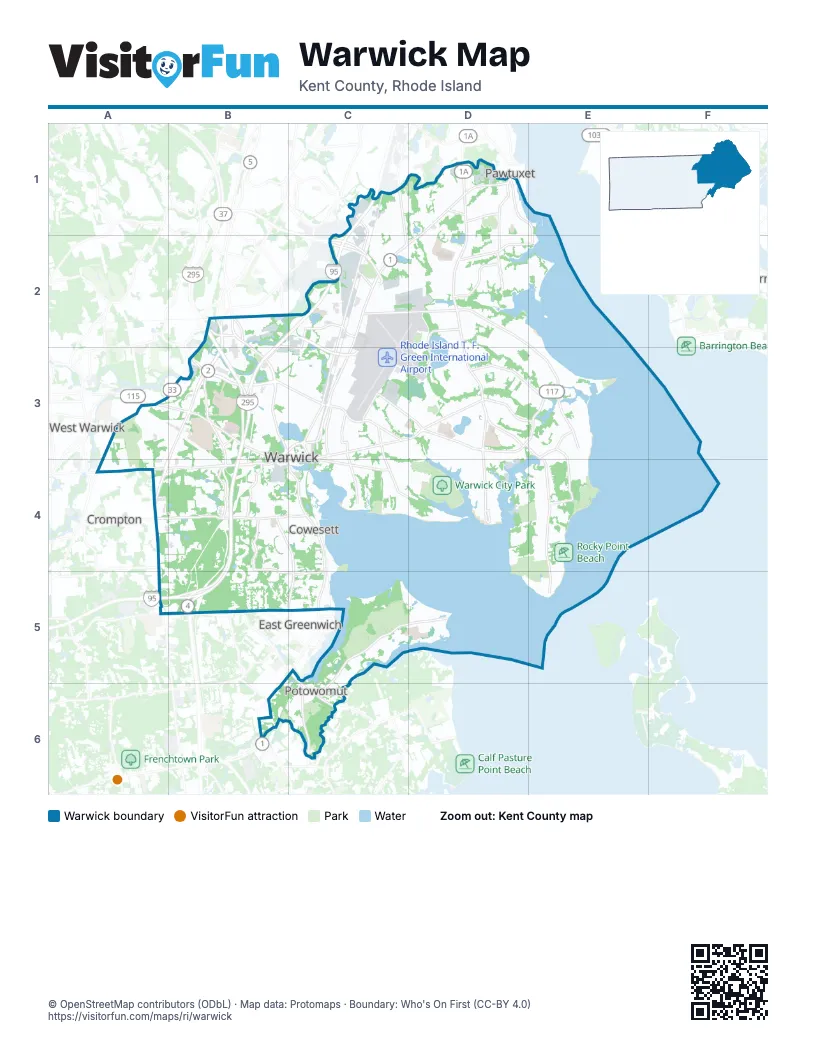
Street index of Warwick
Each street on the sheet and the grid squares it crosses.
- Airport Connector RoadC2, C3
- I 295B3
- Lincoln Avenue FreewayC2
- Airport ConnectorC2, C3
- Post RoadD1, C2, D2, C3, B4, C4, C5, B6
- West Shore RoadD2, E2, C3, D3, E3
- Warwick AvenueD1, D2, D3
- Bald Hill RoadB2, B3, A4, B4
- Quaker LaneA3, B3, A4, B4, A5
- Greenwich AvenueB2, B3, B4
- Centerville RoadA4, B4
- East AvenueB3
- Main AvenueB3, C3
- Oakland Beach AvenueD3, D4
- Post Road ExtensionC3
- Elmwood AvenueC1, C2, D2
- Veterans Memorial DriveB3, C3, B4
- Lambert Lind HighwayB2, B3
- Legris AvenueA4
- Ginsu WayA4
- College Hill RoadB3
- Main StreetC5
- Cowesett AvenueA4
- Jefferson BoulevardC1, C2, C3
- Cowesett RoadA4, B4, C4
- Narragansett ParkwayD1, E1, D2, E2
- Toll Gate RoadA3, B3, B4
- Sandy LaneD3, E3
- Airport RoadC2, D2
- Strawberry Field RoadC3, D3
- West Natick RoadB2
- New London AvenueA3, A4
- Division StreetC5
- Providence StreetA3, B3
- Ives RoadC5, D5, C6
- Warwick Neck AvenueD3, E3, E4, E5
- Buttonwoods AvenueC3, C4, D4
- Major Potter RoadA4, B4, B5, C5
- Church AvenueD3, E3
- Commonwealth AvenueB3, B4
- Love LaneB4, C4, B5, C5
- Rocky Point AvenueE4
- Old Forge RoadC5, C6
- Long StreetC3, C4
- Potowomut RoadC6
- Fair StreetD1, D2
- Lake Shore DriveD2, D3
- Warwick Industrial DriveC3
- Tidewater DriveE3
- Squantum DriveD2
- Larchwood DriveB4
- Metro Center BoulevardB2, C2, B3, C3
- Diamond Hill RoadB4
- Atlantic AvenueD1
- Hardig RoadB4
- Nausauket RoadC3, C4
- Palmer AvenueE3, E4
- Samuel Gorton AvenueE3
- Kilvert StreetC2
- Lincoln AvenueC2
- Spring Green RoadD2
- George Arden AvenueC3
- Longmeadow AvenueE3
- Suburban ParkwayD4
- Gertrude AvenueC3
- Harrison AvenueD1
- Cedar StreetC5
- Groveland AvenueC3
- Kenyon AvenueC3, C5
- Coronado RoadC2
- Burr AvenueD4
- Leon E Whipple RoadB3
- Water StreetB4, C4, C5
- East Greenwich AvenueA4
- Stender BoulevardD4
- Rotary 1D2
- Gloria DriveC3
- Rotary 2D2
- Forge RoadC6
- Perimeter RoadC2, D2, C3, D3
- Namquid DriveD2, E2
- Cedar Pond DriveB4
- Gilbert Stuart DriveB5
- Algonquin DriveD2, E2
- Red Chimney DriveB4, C4
- Sleepy Hollow Farm RoadB4
- Steven O' Connor BoulevardD4
- Bob Leavitt TrailD4
- Eagle RunB4
- Point AvenueE3
- Sea View DriveD4
- Pequot AvenueD3, D4
- Arnolds Neck DriveC4
- Knight StreetB2
- Commerce DriveD2
- Harrington AvenueC1, C2
- Beach AvenueD3, E3
- Narragansett Bay AvenueD4, E4
- Chapmans AvenueB3, C3
- Fairfax DriveD1, D2
- Hillard AvenueB3, C3
- Universal BoulevardA3, B3
- Crossings BoulavardB3
- Shawomet AvenueE3
- Greenwood AvenueB3, C3
- Potters AvenueB3, C3
- Meadow View AvenueD4, E4
- Varnum DriveB5
- Miantonomo DriveD2
- Natick AvenueB3, C3
- North Country Club DriveD1, D2
- Parkside DriveD1, D2
- Castle Rocks RoadB4, B5
- Byron BoulevardD1
- Chestnut StreetC1, C2
- Capron Farm DriveC4
- Asylum RoadC4, D4
- Norwood AvenueC1, C2
- Hoxsie AvenueD2
- Cove AvenueD3
- Beachwood DriveC5, D5
- Robert Shapiro DriveB3, B4
- Williamsburg DriveC3
- Country View DriveA3
- Randall AvenueD4, E4
- Greeley AvenueC3
- Lansdowne RoadD2
- Sand Pond RoadC2, D2
- Crestwood RoadC4
- Williamsburg CircleC3
- Grove AvenueE3
- Arlington AvenueE3
- Channel ViewD4
- Tiffany AvenueD4, E4
- Pawtuxet AvenueC1, D1
- Maple StreetC1, C2
- Bellman AvenueE2, E3
- Spencer AvenueC5
- Kirby AvenueD4, E4
- Heritage DriveB5
- Merrymount DriveD2
- Easton AvenueD2
- Adams StreetD1
- Second Point RoadD3, D4
- Stillwater DriveD3
- Irving RoadD1
- Warner Brook DriveD3
- Claypool DriveC4
- Country Club DriveD2, E2
- Douglas RoadB3, B4
- Dryden BoulevardD1
- Budlong Farm RoadC4
- Draper AvenueE3
- Highland AvenueB4, C4
- Washington StreetD1
- Columbia AvenueD1, D2
- Main ChannelD4, E4
- Welfare AvenueC1, C2
- Palace AvenueC3
- Willow Glen CircleD3
- Baldwin RoadB3, B4
- Burt StreetC3
- Elm StreetC1, C2
- Shamrock DriveD4
- Trent AvenueD3
- Betsey Williams DriveD3
- Sumner AvenueC1, D1
- Manola AvenueC1
- Hope AvenueE3
- Tennyson RoadD1
- Milton RoadD1
- Cole Farm RoadD2
- Pettaconsett AvenueC2
- Spencer Woods DriveA4, B4
- Bayview AvenueC5
- Whitford StreetC3, D3
- Holmes RoadD1
- Overhill RoadC5
- Park AvenueE3
- George StreetD1
- Canfield AvenueD3, D4
- Carlton AvenueE4
- Spooner AvenueC3
- Gordon AvenueD3, D4
- Vernon StreetD2, D3
- Coburn StreetD4
- Partition StreetD2
- Morse AvenueC3
- Pace BoulevardA3, B3
- Monroe StreetD1, D2
- Vancouver AvenueB3
- Park View AvenueD1
- Leroy AvenueD4, E4
- Sharon StreetC3
- Range RoadD3
- Vera StreetC3
- Vineyard RoadD3
- Haswill StreetD3, D4
- Van Buren StreetD1
- Sefton AvenueD3
- Killey AvenueD3
- Hilton RoadD3
- Lakedell DriveD5
- Mill Cove RoadE3
- Gorton Lake BoulevardB3, C3
- Horse Neck RoadD3, D4
- Jefferson StreetD1
- Keeley AvenueC4, D4
- Payton AvenueE3
- Sprague AvenueD2, D3
- Custer StreetD3, D4
- Greenbush RoadB5
- Harmony CourtD2
- Reynolds AvenueD3, D4
- Trinity StreetC3
- Posnegansett AvenueD1, D2
- Service AvenueC2
- Hollis AvenueD3, D4
- Oak Tree AvenueC3, C4
- Shenandoah RoadB4, C4
- Pierce AvenueC1, C2
- Shand AvenueD3, D4
- Cowesett Green DriveB4
- Lucas RoadC6
- Pinegrove AvenueD3, D4
- Riverside AvenueE3
- Sargent StreetC2
- Madison StreetD1
- Brentwood AvenueC3
- Dahlia StreetD2
- Wood StreetD4
- Shadow Brook DriveB4, B5
- Covington DriveB3
- North StreetB2
- Inman AvenueC3
- Honeysuckle RoadD2
- Joseph CourtB4, B5
- Bend StreetD3, E3
- Edgehill RoadD2, D3
- Winter AvenueE3
- Ann Mary Brown DriveD2
- Missouri DriveC4
- Burbank DriveC3
- Glen DriveD3, A4
- Blanchard AvenueD2
- Cottage Grove AvenueD3, D4
- Governors DriveB5, C5
- Northampton StreetD1
- Weeden DriveC6
- Viceroy RoadB4
- Massachusetts AvenueC2
- Underwood AvenueD1
- Ottawa AvenueD4
- Tanner AvenueB3
- Maryland AvenueC2
- Smith StreetC3
- Vaughn AvenueC3
- Peabody DriveD2, D3
- Alvin StreetB3, C3
- Hilltop DriveC5
- Third AvenueC1, D1
- Canna StreetD2
- Inez AvenueC3, C4
- Massasoit DriveC2, D2
- Pocahontas DriveD2
- Grandview DriveC4
- Liverpool StreetC3
- Falcon AvenueD2
- Stephens AvenueC3
- Brookwood RoadD3
- Northup StreetD4
- White AvenueC3, C4
- Cedar Swamp RoadD3
- Briarcliff AvenueD5, E5
- Twin Oak DriveD2
- Duncan RoadC4, D4
- Charlotte DriveD5
- Chambly AvenueD1
- Staples AvenueC4
- Wingate AvenueC1, D1
- Old Mill BoulevardE3
- Audubon RoadD1, E1
- Spring Grove AvenueD3
- Heath AvenueC1, D2
- Kiwanee RoadD2
- Villa AvenueC3
- Bellevue AvenueD2
- Gorham AvenueC3
- Gilbert StreetB3
- John StreetD4
- Pine StreetC2
- Hedgerow DriveB4, B5
- Pinehurst AvenueD4
- Sherwood AvenueD1
- Edmond DriveB4
- Christina DriveA4, B4, A5, B5
- Pettis DriveD3, D4
- Whipple AvenueE3
- Cushing RoadD1, D2
- Second AvenueC1, D1
Things to do on the Warwick map
Places on the map
- Apponaug Baseball Complex
- Apponaug Cove
- Apponaug Station Post Office
- Bald Hill
- Bishop Hendricken High School
- Blue trail
- Brayton Cemetery
- Bruce Sundlun Terminal
- Brush Neck Cove
- Buttonwoods Cove
- Cedar Hill School
- Chepiwanoxet Park
- Confreda Farms (Warwick)
- E - Economy
- Goddard State Park
- Gorton Pond
- Harbor Lights Golf Course
- Inskip Auto Mall
- Kent Hospital
- Lincoln Park Cemetery
- Midland Commons
- Pilgrim High School
- Posnegansett Pond
- Potowomut Farm
- Potowomut Golf Club
- Potowomut Pond
- Rhode Island Mall
- Rhode Island T. F. Green International Airport
- Rocky Hill School
- Rocky Point Beach
- Sand Pond
- Valley Country Club
- Warwick City Park
- Warwick Country Club
- Warwick Cove
- Warwick Executive Park
- Warwick Mall Shopping Center
- Warwick Pond
- Warwick Public Schools
Next to Warwick
- Crompton
- East Greenwich
- Pawtuxet
- West Warwick
© OpenStreetMap contributors, Open Database License, openstreetmap.org/copyright · Map data: Protomaps · Boundary: Who's On First (CC-BY 4.0); U.S. Census Bureau