

South Carolina map
Columbia map
About 144,788 people live here (Census Bureau, 2024 estimate). The sheet's index lists 300 streets; Percival Road, William Earle Berne Beltway and Leesburg Road cross the most grid squares. Things to do inside the boundary: Columbia Museum of Art, Columbiana Centre and EdVenture Children's Museum.
Open the map (PDF, US Letter)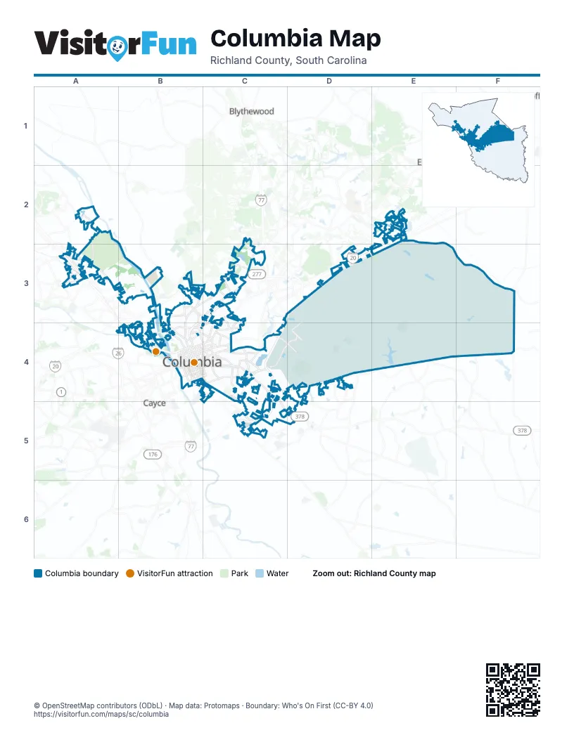
Street index of Columbia
Each street on the sheet and the grid squares it crosses.
- William Earle Berne BeltwayC3, D3, C4, C5
- I. DeQuincey Newman FreewayB3, C3, B4
- Gervais StreetB4, C4
- Garners Ferry RoadC4, C5, D5
- North Main StreetB3, C3, B4
- Blossom StreetB4, C4
- Broad River RoadA3, B3, B4
- Rosewood DriveB4, C4
- Assembly StreetB4, C4
- Devine StreetB4, C4
- Bull StreetB4, C4
- Main StreetB4
- McCords Ferry RoadF3, F4
- Hampton StreetB4, C4
- Elmwood AvenueB4, C4
- Huger StreetB4
- Two Notch RoadC3, C4
- Taylor StreetB4, C4
- Sunset DriveB4
- Millwood AvenueC4
- Williams StreetB4
- Beltline BoulevardC4
- River DriveB4
- North Beltline BoulevardC3, C4
- West Belt Line BoulevardC3, C4
- Fairfield RoadB3, C3
- Wilson BoulevardC3
- Marshall StreetB4, C4
- Academy StreetB4, C4
- Datura RoadC4
- Crosshill RoadC4
- Jarvis Klapman BoulevardB4
- Leesburg RoadC4, D4, E4, F4
- Farrow RoadC3, B4, C4
- Harden StreetB4, C4
- Percival RoadE2, C3, D3, E3, C4
- Colonial DriveB3, C3, B4
- Marion AvenueC4, D4
- Wildcat RoadD3, E3, C4, D4
- Park StreetB4
- Shop RoadC4, C5
- Forest DriveC4
- Trenholm RoadC4
- Fort Jackson BoulevardC4
- Strom Thurmond BoulevardC4, D4
- Wayne StreetB4
- Bluff RoadB4, C4, C5
- South Beltline BoulevardC4, C5
- Saluda AvenueC4
- Harbison BoulevardA3
- Whaley StreetB4, C4
- Lake Murray BoulevardA3
- Monticello RoadB3
- Greystone BoulevardB4
- Buckner RoadB3, C3
- Bush River RoadB4
- Clemson RoadE2, D3
- Pineview RoadD5
- South Harden StreetC4
- Windhill DriveB3
- Olympia AvenueB4
- Alpine RoadD3
- Hurtgen Forest RoadD3, E3, D4
- Lost Creek DriveA2, A3
- Screaming Eagle RoadE2, E3, F3
- Pickens StreetB4, C4, D4
- Lincoln StreetB4
- Heyward StreetB4, C4
- Senate StreetB4, C4
- Sumter StreetB4
- Laurel StreetB4, C4
- Gadsden StreetB4
- Kilbourne RoadC4
- Gregg StreetB4, C4
- Marion StreetB4, C4
- Greene StreetB4, C4
- Washington StreetB4, C4
- Richland StreetB4, C4
- Veterans RoadC4, C5
- Calhoun StreetB4, C4
- Pendleton StreetB4, C4
- Lady StreetB4, C4
- Barnwell StreetB4, C4
- Tank Hill ParkwayD4
- Columbiana DriveA3
- Glenwood RoadC4
- Columbia College DriveB3, C3
- Blanding StreetB4, C4
- South Kilbourne RoadC4
- Spears Creek Church RoadE2
- Covenant RoadC4
- Pulaski StreetB4
- South Ott RoadC4
- Henderson StreetB4, C4
- Beckman RoadC3
- Lighthorse StreetD4
- Pisgah Church RoadC3
- Gracern RoadB4
- Cushman DriveC3
- Duke AvenueB3
- Harrison RoadC4
- Pine Belt RoadC3, C4
- Boyden Arbor RoadD3
- College StreetB4, C4
- Wilkes RoadC3
- Bower ParkwayA3
- Stoneridge DriveB4
- Chestnut StreetC4
- Barhamville RoadC4
- River Hill CircleB4
- Santee AvenueC4
- Parkridge DriveA3
- Lucius RoadB4
- Kinley RoadA3
- Brennen RoadC4
- Padgett RoadD4
- Confederate AvenueB4
- Slighs AvenueB4, C4
- Colonial Life Boulevard WestB4
- Old Percival RoadD3
- Arrowwood RoadB4
- Hurtgen Forest DriveC4, D4
- Pinehurst RoadC4
- Fernandina RoadA3
- Prescott RoadC3
- Clement RoadB3, B4
- Frye RoadC3
- Germany StreetC4
- Muller AvenueB3
- Ott RoadC4
- Mallet Hill RoadD3
- Powell RoadC3
- Plowden RoadC4, C5
- Woodcross DriveA3
- Old Leesburg RoadD4
- Marlboro StreetB4
- Piney Grove RoadA3
- North Arrowood RoadB4
- Medical Park RoadB4
- Kennerly RoadA3
- Hart StreetB4
- Mason RoadC3
- Fontaine RoadC3
- Caughman RoadD4
- Smallwood RoadD3
- Skyland DriveB4
- Hollingshed RoadA2
- Saint Andrews RoadB3
- Browning RoadB4
- Pavillion StreetC4
- Providence StreetC4
- Piney Woods RoadA3
- Pinehurst DriveC4
- Willowby StreetC4
- Trotter RoadD4
- West Colonial Life RoadB4
- Morninghill DriveB4
- Lower Richland BoulevardD4
- Bethel Church RoadC3
- Harmon RoadE4
- Burnette DriveB4
- Westmore DriveC3
- Dutch Square BoulevardB4
- East Boundary RoadD3
- Congress RoadF4
- Mt Elon Church RoadE4
- Colonels Creek RoadE3, F3, F4
- Hartsville Guard RoadD4
- Inchon RoadC4, D4
- Artillery RoadE3, E4
- Range RoadD3
- Jacobs Millpond RoadE2
- Telephone RoadD3, E3, D4
- Jackson BoulevardC4, D4
- Wheat StreetB4, C4
- Johnson Rifle RoadE3
- Utah Beach RoadC4, D4
- Ivy RoadD4
- Liberty Division RoadC4, D4
- 4th Division RoadD4
- Atlas RoadC5
- Messers Pond RoadE3, F3
- Century Division AvenueC4
- Geology RoadA3, B3
- Wilmot AvenueC4
- Golden Arrow RoadD4
- Sightseeing Division AvenueC4
- Shady LaneA3, C4
- Duncan StreetC4
- Greenlawn DriveC4, C5
- Monroe StreetC4
- Devereaux RoadC4
- Columbiana CircleA3
- King Charles RoadC4, D4
- Statue of Liberty RoadF3
- Heidt StreetC4
- Shivers RoadB3
- Washington RoadC4, D4
- Bivouac RoadF3
- Oak StreetC4
- Maple StreetC4
- Bert FridayA3, B3
- Faison DriveC3
- Youth Services DriveA3
- Woodrow StreetC4
- Catawba StreetB4, C4
- Champion Hill StreetC4, D4
- King StreetC4
- Washington Light Infantry RoadE4
- Alexander CircleC4
- Northwood StreetB4
- Superior StreetC4
- Truman StreetC3
- Frontage RoadC3, B4
- Byron RoadC4, C5
- Montgomery AvenueC4
- South Kings Grant DriveC4
- Easter StreetC3
- Ridgewood AvenueB3, B4
- International BoulevardB3
- Burnside DriveC4, C5
- Fountain Lake RoadC5
- South Holly StreetC4
- Lorick AvenueB3, C3
- Palmetto AvenueB3, B4
- Carter StreetC3, D4
- Read StreetC4
- Hillcrest AvenueB3
- Abingdon RoadB3, B4
- Kathwood DriveC4
- Urgent Fury StreetD4
- Deerwood StreetC4
- Queen StreetC4
- Redbay RoadE2
- Woodcreek RoadE2
- Old Woodlands RoadC4, C5
- George Rogers BoulevardC4
- Adger RoadC4
- Holmes AvenueB3, C3
- Lightning StreetC4, D4
- Ninety Six CourtD4
- South Edisto AvenueC4
- Ames RoadC3
- Cedar TerraceC4
- South Bull StreetC4
- Wildwood AvenueB3
- Ulmer RoadD4
- Colleton StreetB3, C3
- Yorkshire DriveC4, D4
- Kings Grant DriveC4
- Prentice AvenueC4
- Waverly StreetC4
- Oceola StreetC4
- Laurens StreetC4
- Hinton StreetC3
- Tet RoadD4
- Twin Lakes RoadD4
- Bratton StreetC4
- Gabriel StreetC3
- The BoulevardC5
- Greene AvenueC4
- Woodlawn AvenueC4
- Hampton PlaceC4
- South Bonham RoadC4
- Sims AvenueC4
- Gauley DriveA2
- Clark StreetB4
- Suber StreetC4
- Randall AvenueB3, C3
- Chimney Hill RoadC5
- Preston StreetC4, D4
- Little RoadC4
- Summerlea DriveB3, B4
- Pine StreetC4
- Woodcreek Farms RoadE2
- Club Ridge RoadE2
- McPineland CircleC3
- Myron CircleC4
- Timberlane DriveC4
- South Woodrow StreetC4
- Kennedy StreetC4
- Washington AvenueC4
- Marthas Glen RoadC4
- Rockwood RoadC4, C5
- Pelham DriveC4
- Howard StreetC4
- Belmont DriveC4
- Leitner RoadD4
- Belvedere DriveC3
- Delverton RoadB3
- Grand StreetB3, B4
- Corporate Park DriveD3
- Isaac StreetC3
- Juniper StreetC3
- Oakland AvenueC3
- Yale AvenueC4
- Warren DriveB4
- Blue Jay LaneB4, C4
- Ashley StreetB3, C3
- Craven StreetB3, C3
Things to do on the Columbia map
Places on the map
- 3 Rivers Greenway
- Ben Lippen School
- Boyden Arbor Pond
- Bush River Village
- Cedar Terrace Shopping Center
- Columbiana Centre
- Columbiana Circle
- Coopers Lake
- Crafts-Farrow Campus
- Davis Pond
- Dupre Pond
- Dutch Square
- Earlewood Park
- East Pointe Plaza
- Elmwood Cemetery
- Five Points
- Fort Jackson
- Fort Jackson Golf Club
- Fort Jackson National Cemetery
- Frankie's Fun Park
- Granby Park
- Greenlawn Memorial Park
- Hammond School
- Hampton Place
- Harbison State Forest
- Hilton Field
- Inchon Lake
- Jim Hamilton - L. B. Owens Airport
- Lake Katherine
- Longstreet Theatre
- Market at Spears Creek
- Owens Field Park
- Owens Field Soccer Fields
- Page Ellington Park
- Petro Stopping Centers
- Riverbanks Zoo
- Riverfront Park
- Ruthledges Pond
- Village Lake
- Weston Lake
Next to Columbia
- Blythewood
- Cayce
- Elgin
- Lugoff
- West Columbia
© OpenStreetMap contributors, Open Database License, openstreetmap.org/copyright · Map data: Protomaps · Boundary: Who's On First (CC-BY 4.0); Quattroshapes (CC BY 2.0)