

South Carolina map
Darlington County map
About 62,425 people live here (Census Bureau, 2024 estimate). The sheet's index lists 300 streets; Davis Street, North Center Road and Lamar Highway cross the most grid squares. Things to do inside the boundary: Darlington Raceway.
Open the map (PDF, US Letter)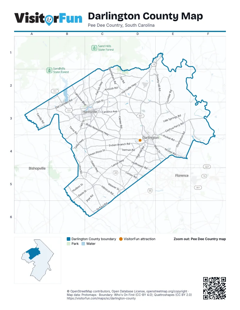
Street index of Darlington County
Each street on the sheet and the grid squares it crosses.
- North Governor Williams HighwayD2, D3, D4
- Oates HighwayC4, C5, D5
- Lamar HighwayC4, D4, C5, C6
- West Bobo Newsome HighwayB2, B3, C3
- Hartsville HighwayC2, D2
- South Main StreetD1, E1, D4, E4
- Harry Byrd HighwayC4, D4
- East Bobo Newsome HighwayC3, C4
- North 5th StreetC2, C3
- South 5th StreetB3, C3, C4
- Davis StreetC3, D4, B5, C5, B6
- North Main StreetE1, D3, D4
- South 4th StreetC3
- West Lydia HighwayB4, C4
- West Carolina AvenueB3, C3
- South Governor Williams HighwayD4
- South Marquis HighwayC3
- North Marquis HighwayC2, C3
- Pearl StreetD4
- Warren StreetC5
- Main StreetD1, D2
- Cheraw HighwayE1
- Segars Mill RoadB3
- West Main StreetC5
- State Highway 151B2
- Timmonsville HighwayD4, D5
- Cashua Ferry RoadD3, E3, F3, E4
- East Seven Pines StreetC4, D4
- Patrick HighwayC2, C3
- Flinns RoadC3, C4
- South Charleston RoadE3, E4
- East McIver RoadD4, E4
- Hoffmeyer RoadD4, D5
- East Lydia HighwayC4
- East Carolina AvenueC3
- Bethel RoadC3, C4
- Ebenezer RoadE4
- 14th StreetB3
- West McIver RoadD4, E4
- Russell RoadD2, E2, B3, C3
- Dunlap DriveB3
- Cashua StreetD3, D4
- Washington StreetD4
- Dorla RoadE3
- Exchange StreetD4
- Public Square RoadD4
- North Brockington StreetD5
- Indian Branch RoadB3, B4, C4, D4
- Society Hill RoadE1, E2, D3, E3
- North Center RoadC2, C3, D3, C4, D4
- East Old Camden RoadB2, C2, D2
- West Old Camden RoadB2, A3, B3
- South Center RoadC4, C5, D5
- Mont Clare RoadD2, E2, D3, E3
- Leavensworth RoadD2, D3
- Lumber RoadE2, E3
- North Rolling RoadC2, C3
- Swift Creek RoadC3
- New Market RoadB2, B3
- Bethlehem RoadC1, C2, D2
- Pocket RoadE3, E4
- Philadelphia StreetC4, D4
- High Hill RoadD4, D5
- Una RoadB4, B5
- Rogers RoadE1, D4, E4
- West Billy Farrow HighwayC3, D3
- East Home AvenueC2, C3
- Antioch RoadC2
- Ousleydale RoadC2
- Ruby RoadB2, C2, C3
- Andrews Mill RoadC4, C5
- Lakeview BoulevardB2, B3, C3
- Mechanicsville HighwayE3
- Georgetown RoadE3, F3, F4
- Weaver StreetD4, C5, D5
- Dovesville HighwayC2, D2
- High Point RoadB3, C3, B4
- Syracuse Community RoadC4, D4, D5
- East Lynches River RoadB5, B6, C6
- Lee State Park RoadB5, C5
- Hibiscus RoadC5
- Floyds RoadC3, D3
- East St Paul RoadC5, D5, C6
- Byrdtown RoadC2, D2
- Windham Town RoadB5, C5
- Lake Swamp RoadD4, D5
- Family RoadA3
- Ashland RoadA2, A3, B3
- Carterville HighwayC5, C6
- Kelleytown RoadB3
- Clyde RoadB3
- Golf Course RoadB3, C3
- Iseman RoadC4, D4
- Turnpike RoadD4, E4
- Green Street RoadD4
- Bull RoadE3
- Quiet Brook RoadD2
- West Lynches River RoadB5
- Railroad AvenueC3, D4, C5
- Kelleybridge RoadA3, B3
- West Seven Pines StreetB4, C4
- West St Paul RoadC6
- Substation RoadA2, B2
- North Charleston RoadE3
- Greenfield RoadE3
- West Washington StreetB3, C3
- West Home AvenueB3, C3
- Rosenwald RoadD2, E2
- Southborough RoadD5
- Trailwood DriveB3
- Sally Hill RoadD5
- Branhams Airport RoadD4
- Church StreetE1
- North Darlington AvenueC5
- Pressley AvenueD1, E1
- Saint Davids StreetD1, E1
- Belle Vue DriveD1
- East Main StreetC5
- 14th Street ExtendedB3
- South Springdale RoadE3, E4
- Ashland-Stokes Bridge RoadB3
- Patrick Society Hill RoadD1
- Sandy Grove Church RoadB5
- Kelly Bridge RoadA3
- New Hope Church RoadA2
- Union Church RoadA3
- Byrd RoadD1
- State Road S-13-29B2
- Cypress RoadB5
- North Sally Hill RoadD5
- Middendorf RoadB2
- St Paul RoadC5
- Flat Creek RoadE2, E3
- Lide Springs RoadE3
- Potato House RoadD4
- New Hopewell RoadC2, D2
- Calvary RoadC3, C4
- East Billy Farrow HighwayD3, D4
- Hudson StreetC3, B5, C5
- Bay Branch RoadC5
- Lawson Grove RoadC4, C5
- Mineral Springs RoadD3
- Auburn School RoadD3
- South Sansbury RoadC4, C5, D5
- Gilchrist RoadD3
- Seven Bridges RoadC5, C6
- Rainbow View RoadA3
- Rhodes Community RoadD3
- Pinedale DriveD3, D4
- Bosmith RoadB5, C5, C6
- Wesley Chapel RoadB3, B4
- Black Creek RoadC2, D2, D3
- Clyde School RoadA3, B3
- Jeffords Mill RoadD2, D3, E3
- Anderson Farm RoadD4, D5
- Tema RoadB3
- Oleander DriveC2, D3
- North Springville RoadD3, E3
- Running Brook RoadD2
- Joye RoadC5, C6
- Tomahawk RoadB4, C4
- Tol RoadC2, D2
- Birdsnest RoadC4
- East Jackson StreetC5
- God Bold DriveE3
- Mayford RoadC4
- Sandbox RoadB4, C4, C5
- Power StreetB3
- Sherrills Mill RoadD2
- Newberry RoadC5, C6
- Everlasting Branch RoadD2, D3
- Hillcrest RoadB3, D4
- Whites CircleD2
- Oak Stump RoadC5, D5
- Mayberry RoadC4
- Old Florence RoadD4, E4
- Cherokee Lady StreetC4
- Sparrow Swamp RoadB3
- Bay RoadB3
- Harmony Hall DriveD3, E3
- Blazing Trail RoadC5, D5
- Cedar Ridge RoadD2
- Round O RoadE3
- Journeys End RoadD3
- Creekview DriveC3, D3, E3
- Pee Dee R C RoadE4, F4
- Arrowhead RoadC3, D3
- Robinson View DriveB2
- Roblyns Neck RoadE2
- Coggeshall RoadE3, E4
- Kelleybelle RoadB3
- Gallowaytown RoadB4
- Timberlake DriveE4
- Owl CircleD2
- Whippoorwill RoadB2, B3
- West Horse Branch TrailD2
- Gandy Siding RoadD2, E2
- Plumfield RoadE2
- Pine StreetE1, D4, C5, D5
- Hummingbird StreetC2
- Crowley Hill RoadD1, D2
- McCowns Millpond RoadD3
- Allen RoadC3
- Quietude RoadC5, C6
- Rancho RoadB2, B3
- Red Hill StreetA3
- Country Club RoadE4, C5
- West Smith AvenueD3, D4
- Kingston DriveA3
- Syracuse StreetD4
- Benny Hill RoadB5
- Palmetto RoadE4
- Abbott RoadE3
- Country Squire RoadD2
- Spring StreetD3, D4
- Mineral Springs StreetB4, C4
- Westover DriveB3
- Jeffries Creek RoadD4
- Cross Swamp RoadB4
- Honeysuckle RoadD2, B3
- Newman Swamp RoadB5, C5
- Fisherman RoadC4, C5
- Snow Hill RoadB3, C3
- Meander DriveD5
- Possum Trot RoadB5
- Fox Hollow DriveB3, D3
- Underground Branch RoadC2
- Pit RoadD3, D4
- Penn RoadE3, E4
- Joja RoadC4
- Dovetail RoadD3, C4
- Lazy Pines RoadD3
- Burlington DriveE1
- Burnt Branch RoadB3, B4
- Melwood RoadB3, B4
- Possum Bay RoadB3, B4
- Hill Creek RoadD4
- Bellyache Branch RoadC3, D3
- North Sansbury RoadC4
- Cherrywood RoadD4, E4
- Great Cypress RoadD3
- Beaverdam DriveB3
- Tolson RoadC5, C6
- Vapor RoadC4
- Persimmons DriveC2
- Silo RoadB2
- Forest DriveD1, B3, D3
- Law Plantation RoadD3
- Sweetbriar RoadB5, C5
- Commanchee StreetC3
- Cottonflower RoadC5
- New RoadC5
- Mill Branch RoadB5
- Candy LaneD4, E4
- Quail Point RoadB3, B4
- Catawba StreetC2, C3
- Long Marsh RoadE3, F3
- Gardner Horton TerraceA3
- Centerville RoadC3
- Buckholts Creek RoadD2
- South Rolling RoadC3
- Goodson Farm RoadE3
- Henry King RoadC3
- Marcus Valley DriveC2
- Grandpa RoadC4
- Country Manor RoadC4
- Pinecone LaneA3
- Wire RoadD3
- Flatnose RoadD2
- Lawson RoadD3
- Mount Olivet RoadC1, C2
- Darlington RacewayD4
- Hannah Pond RoadA3
- South 6th StreetC3
- Old Muldrow's Mill RoadD5
- Egypt Farm RoadC3
- Leisure RoadC5
- Hartland DriveC3
- Dewitt CircleD5
- Hollybush RoadD5
- Deer Run DriveB3, C5
- Springwood DriveB3, E4
- West College AvenueB3, C3
- Hammer RoadC5
- Crescent DriveC3
- Honeydew RoadE4
- Jacks Branch RoadC5, D5
- Bob Cat DriveF3
- Woodduck RoadB3
- Spring Valley RoadC2
- Bryant StreetD3
- Piano RoadE4
- Riverview RoadE4
- Dance DriveC3, D3
- Santee DriveB3
- Folly RoadC2
- Oakdale DriveB3, E4
- Homeplace RoadD2
- Divinity RoadE3
- West Broad StreetD4
Things to do on the Darlington County map
Places on the map
- Adurndale Farms Pond
- Andrews Millpond
- Bay Lake
- Bay Road Elementary School
- Beaver Creek Golf Club
- Beaverdam Millpond
- Boyds Pond
- Byerly Park
- Chapmans Pond
- Dargan's Pond
- Darlington
- Darlington Country Club
- Darlington County Jetport
- Darlington High School
- Darlington Raceway
- Fox Creek Golf Club
- Gilbert Lake
- Harolds Mill Pond
- Hartsville
- Hartsville Country Club
- Hartsville Regional Airport
- Jeffords Millpond
- Lake Darpo
- Lake Redwing
- Lamar
- Lowthers Lake
- McCowns Millpond
- McIntosh Millpond
- Muldrow Mill Pond
- North Hartsville
- Palmetto Shores Lake
- Prestwood Country Club
- Prestwood Lake
- Ramseys Millpond
- Segars Millpond
- Slag
- Society Hill
- Wachovia Hills Lake
- Wilbur Flowers Pond
- Williams Lake
Next to Darlington County
- Bishopville
- Florence
© OpenStreetMap contributors, Open Database License, openstreetmap.org/copyright · Map data: Protomaps · Boundary: Who's On First (CC-BY 4.0); Quattroshapes (CC BY 2.0)