

South Carolina map
Oconee County map
About 82,475 people live here (Census Bureau, 2024 estimate). The sheet's index lists 300 streets; East Main Street, North Highway 11 and West Main Street cross the most grid squares. Things to do inside the boundary: Devils Fork State Park, Lake Hartwell State Park and Oconee State Park.
Open the map (PDF, US Letter)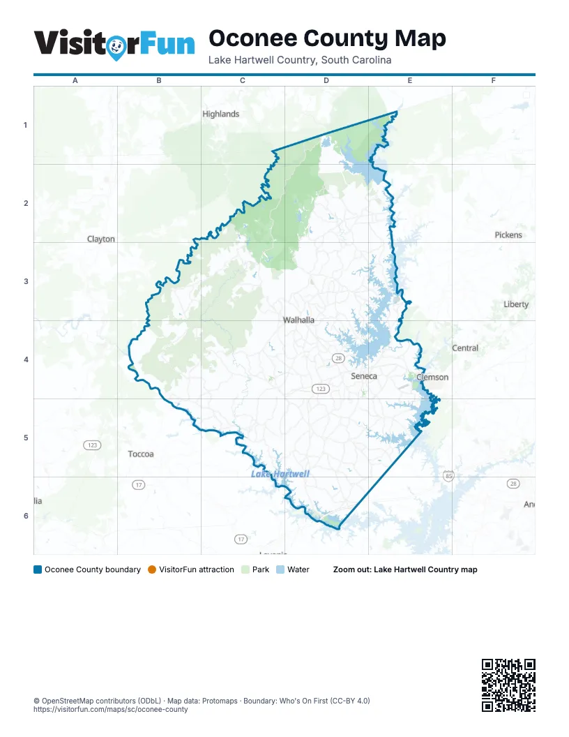
Street index of Oconee County
Each street on the sheet and the grid squares it crosses.
- Welcome Center PlaceD6
- South Highway 11D4, D5, D6
- Long Creek HighwayB3, B4, C4
- North Highway 11D2, E2, D3, D4
- Highlands HighwayC2, C3, D3
- Toccoa HighwayC4, C5
- Blue Ridge BoulevardD4
- Sandifer BoulevardD4
- Clemson BoulevardE4
- East Main StreetD2, D3, C4, D4, E4
- West Main StreetD2, D3, C4, D4
- Bypass 123D4, E4
- West Windsor StreetC4
- East Windsor StreetC4
- Burton DriveD4
- Cherokee Foothills Scenic HighwayE2, D6
- Tiger BoulevardE4
- Highway 11E2
- East Currahee StreetC5
- Lookout Mountain Scenic HighwayB3
- West Oak HighwayD4, D5, E5
- Whitewater Falls RoadD1, D2
- Pickens HighwayD3, E3
- Wells HighwayD4, E4, D5, E5
- Rochester HighwayE3, E4
- Keowee School RoadD3, D4
- Stamp Creek RoadD2, D3, E3
- Westminster HighwayC4, D4
- Cleveland Pike RoadB5, C5
- Highway 59D5, D6
- Highway 182D5, D6
- Tokeena RoadD4, D5
- Oakway RoadD5
- Wiginton RoadD1
- Sheep Farm RoadD4
- South Oak StreetD3, D4
- Pendleton RoadE4
- East Fairplay BoulevardD6
- West North 1st StreetD4
- East North 1st StreetD4, E4
- North Catherine StreetD3
- East Pickens HighwayE3
- Lakeshore DriveD3, D6
- West Fairplay BoulevardD6
- North Oak StreetD3, D4
- South College StreetD3, D4
- Old Greenville HighwayE4
- Chattooga Ridge RoadB3, C3
- Dr Johns RoadC4, C5
- Cheohee Valley RoadD2, D3
- Coffee RoadD3, C4, D4
- Cassidy Bridge RoadB3, C3
- Unity Church RoadB4, C4, B5
- Brasstown RoadB4
- Cobb Bridge RoadC4
- Jocassee Lake RoadD2, E2
- Return Church RoadD4, D5
- Greenfield RoadC5, D5
- Blackjack RoadC5, D5
- Shiloh RoadE4
- Welcome Church RoadB4, C4, B5
- Burnt Tanyard RoadD3
- Flat Shoals RoadD2, D3
- Pine Grove RoadB5, D5, E5, E6
- Whetstone RoadC3
- Nimmons Bridge RoadE2, E3
- Poplar Springs RoadD4
- Doyle StreetC4
- North Little River RoadD2
- Ebenezer RoadD3, D4
- Cross Creek DriveD4, D5
- Oconee Station RoadD3
- Playground RoadC3, D3
- Sitton Mill RoadD5, E5
- Oconee Creek RoadD3
- Pickett Post RoadD3
- West Pine Grove RoadD6, E6
- Friendship RoadD3, E4, E5
- Tamassee Knob RoadD2, D3
- Coneross Creek RoadE5
- Old Clemson HighwayE4
- Shallow Ford RoadD2, E2
- Rodgers RoadD5, D6
- Verner Mill RoadC3
- Academy RoadB3
- Martin Creek RoadE5
- Old Walhalla HighwayD4
- Well Mountain RoadB4, C4
- Bethel Church RoadD3, D5
- Stamp Creek Landing RoadD3, E3
- Whitmire Church RoadD2
- Bountyland RoadD4
- Rock Crusher RoadC4, D4
- Lake Jemiki RoadC3
- Burns Mill RoadD3, D4
- Knox RoadD3, E3
- Jenkins Bridge RoadC5
- Oak Grove RoadC4, D4
- South Retreat RoadC5, D5
- Armstrong RoadD4, D5
- South Friendship RoadE5
- East Stamp Creek RoadD3, E3
- Barton Creek RoadB4, B5
- Singing Pines RoadE4, E5
- Tabor RoadC5
- Radisson RoadD4, D5
- Snow Creek RoadD5
- Black Mountain RoadB4
- Oak Creek RoadD5
- Little Choestoea RoadD5
- South Cove RoadD4
- Dairy Farm RoadD5, D6
- Hesse HighwayC4, D4
- Safety Harbor RoadD3, D4
- Fall Creek RoadE2, B3, C3
- Chauga RoadC5
- Lawrence Bridge RoadE4
- New Madison RoadC5
- North Jenkins Bridge RoadC4, C5
- Richland RoadD4
- Mountain RoadD4
- South Radio Station RoadD4, D5
- Old Chapman Bridge RoadE2
- Campbell Bridge RoadD5, E5
- Park AvenueD2, C4
- Country Junction RoadD3
- Wolf Stake Church RoadD3
- Clearmont RoadD4
- South Walnut StreetD4, E4
- Earles Grove RoadD5
- Davis Creek RoadE4
- Earls Mill RoadD5
- Seneca Creek RoadE4
- Friendship Valley RoadE5
- Babb RoadE5
- Callaham RoadD5
- Jarrett Bridge RoadB5, C5
- Smith Dairy RoadD5
- Hunt RoadE5
- Collins RoadD3, D4, C5
- Sitton Shoals RoadD5
- McAlister RoadD4
- Torrington RoadD3, D4
- Sam Brown RoadD5
- Katelynn LaneE3, E4
- Berry Farm RoadC4, C5
- Fowler RoadD3
- Cross Creek RoadD2
- West South 4th StreetD4
- Lecroy RoadD3
- Old Seneca RoadD4
- Crestwood DriveD2
- Earlestead DriveD3
- West Union RoadD4
- West Bryant RoadD3, D4
- Springbrook RoadD3
- Easy StreetD2, E4
- Rocky Knoll RoadC3
- East North AvenueC4, D4
- Cedar Wood Ranch RoadC5
- Richey RoadD6
- Crystal LaneD4, E5
- Mountain Springs RoadD3
- Brown Farm RoadD5
- West Bear Swamp RoadD4
- West Cherry RoadE5
- Mount Pleasant RoadD5
- Boat Ramp RoadD5, D6
- Old House RoadD4
- Ramsey Creek RoadC4
- Zion RoadC3, C4
- Flat Rock RoadC4, D4
- East South 6th StreetD4, E4
- Dickard RoadD4
- Goddard AvenueE4
- Carradine RoadE4, E5
- Snead RoadD3
- Coneross Park RoadE5
- East Bennett RoadC4, D4
- East Spearman RoadD5
- Melton RoadD4
- Old Station RoadD3
- Alberts RoadD4
- Dixon RoadC5
- Fairfield RoadD3
- Stewart RoadD4
- Taylor RoadD3
- Mountain View RoadD3
- Mauldin Mill RoadD4
- East Bear Swamp RoadD4
- McKinney Falls ParkwayE2
- Durham RoadD6
- Isbell RoadD6
- Winstead RoadD3
- North Pine StreetD3, D4
- Keowee River RoadE3
- South Union RoadD5, D6
- Fairview Church RoadD4, E4
- Feltman RoadD6
- Levi LaneD4
- Boyd Moss RoadD3
- Broadway StreetE4
- Perry Woolbright RoadE5
- J P Stevens RoadE4, E5
- Creekwood LaneD3, D4
- Miller Farm RoadD5
- West Spearman RoadD5
- Lindsay RoadE4
- Dynamite RoadD2
- Northampton RoadD4
- Friendly DriveD2, D3
- North Townville StreetD4
- High Falls RoadE3
- Mormon Church RoadD4, E4
- West Halfway Branch RoadD4
- Bennettsville RoadE2
- Boone Creek RoadD2, E2
- Plant RoadD4
- Bolt RoadC4
- Ridgecrest RoadD5
- New Cut RoadD3, E3
- Snow Creek Church RoadD5
- Evatt RoadD3
- North Radio Station RoadD4
- North Walnut StreetD4
- Phillip Lear RoadC5
- Biggerstaff RoadD4
- Carson RoadE4
- West Bennett RoadC4
- Bruce RoadD5
- Keowee Turtlehead RoadE2
- Harbin RoadD5
- Hefner RoadD4
- Robin DriveD4
- Herring RoadD6
- Singleton RoadD4, C5
- Scenic Heights RoadD3
- Donald RoadD5
- Newry RoadE4
- Stribling RoadD4
- Aqua TrailD4
- South Abbort RoadC4
- East Halfway Branch RoadD4
- Owens DriveD3, D4
- Deaton RoadD3
- Cain RoadD6
- Old School House RoadD4
- Alpine DriveE4
- West North AvenueC4
- Cross Roads DriveD5
- North Burns Mill RoadD3
- Burriss RoadD5
- Antebellum RoadD4, D5
- Whitfield RoadD6
- Madison RoadD5
- Doctors RoadD6
- West South 6th StreetD4
- Dales DriveC5
- West Sizemore RoadE4
- Randys RoadC5
- North Singing Pines RoadE4
- Seldomridge RoadC4
- Lola DriveD6
- South Sitton Mill RoadD5
- South Little River RoadD2
- Cemetery RoadC3
- Five Forks RoadC4
- Rutledge RoadC4
- South Maple StreetD3
- Old Georgia RoadD4
- Snowhill RoadD6
- Hall StreetD6
- Old Cherry RoadE5
- Old Dobbins Bridge RoadD6
- Rich Mountain RoadC3, C4
- North Horseshoe Bridge RoadC4, C5
- Jumping Branch RoadD2
- Spy Rock RoadB4, C4
- Little Longnose RoadB4
- Bad Creek RoadD1
- Stribling Shoals RoadC4
- Cooper RoadB4, B5
- Damascus Church RoadB3, B4
- River RoadB5, C5
- Village Creek RoadC2
- White Cut RoadD3
- Cliffs South ParkwayE2
- Alexander RoadD2, D3, E4
- Ross Mountain RoadC3
- Cherokee Lake RoadD2
- South Flagship DriveE3
- Battlecreek RoadB3, B4
- Weldon RoadC4, C5
- Ridge RoadD2, C5
- Chattooga Lake RoadC2
- Burrells Ford RoadC2, D2
- Pine Mountain RoadD2
- Cedar Creek RoadC3, C4
- Chickasaw DriveD5, D6
- Musterground RoadD1, E1
Things to do on the Oconee County map
Places on the map
- Applewood Shopping Center
- Bad Creek Reservoir
- Beaverdam Watershed Five Lake
- Beaverdam Watershed Four Lake
- Blue Ridge Elementary School
- Bookers Lake
- Browns Lake
- Camp Chatuga
- Chapman Bridge Oconee Bell Preserve
- Chattooga Belle Farm
- Chattooga Lake
- Chau Ram County Park
- Chauga Rapids Disc Golf Course
- Coneross Creek Reservoir
- Crawford Mill Farm
- Crooked Creek RV Park
- Crystal Lake
- Devils Fork Campground
- Devils Fork State Park
- Ellicott Rock Wilderness
- Hartwell Village
- Hicks Pond
- High Falls County Park
- Lake Becky
- Lake Cherokee
- Lake Hartwell
- Lake Hartwell State Park
- Lake Keowee
- Lake Leroy
- Oconee County Regional Airport
- Oconee Point Campground
- Oconee State Park
- Salem
- Seneca
- Tugalo Lake
- Utica
- Walhalla
- West Union
- Westminster
- Whitewater Lake
Next to Oconee County
- Central
- Clayton
- Clemson
- Highlands
- Liberty
- Pickens
- Toccoa
© OpenStreetMap contributors, Open Database License, openstreetmap.org/copyright · Map data: Protomaps · Boundary: Who's On First (CC-BY 4.0); Quattroshapes (CC BY 2.0)