

South Dakota map
Lincoln County map
About 75,244 people live here (Census Bureau, 2024 estimate). The sheet's index lists 300 streets; 288th Street, SD Highway 11 and US Highway 18 cross the most grid squares. Also on it: Adventure Elementary School, Atkins Waterfowl Production Area and Avera Heart Hospital.
Open the map (PDF, US Letter)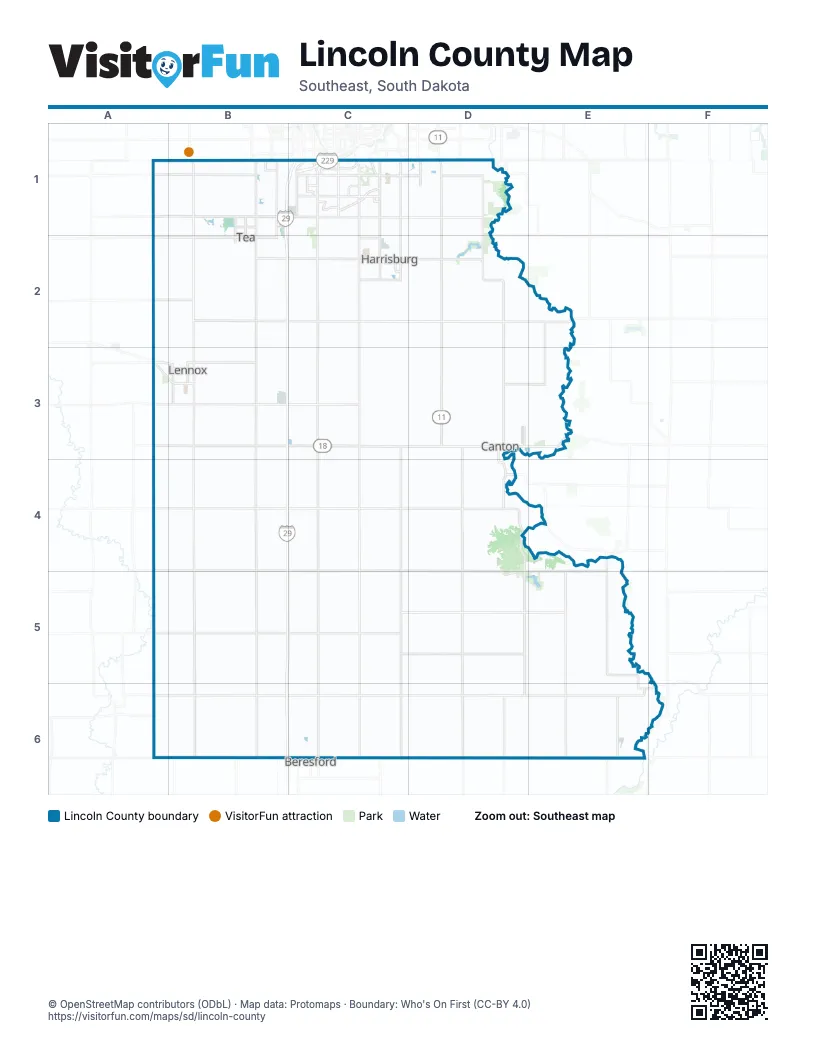
Street index of Lincoln County
Each street on the sheet and the grid squares it crosses.
- South I-29B1, C1
- West I-229C1
- SD Highway 11D1, D2, D3, D4, D5, D6
- US Highway 18B3, C3, D3, A4, B4, C4
- SD Highway 46A6, B6, C6, D6, E6
- 271st StreetA1, B1, C1, D1
- SD Highway 115C1, C2, C3
- SD Highway 17B1, B2, B3
- 282nd StreetA3, B3, E3
- SD Highway 44A3, B3
- South Louise AvenueC1, C3
- South Minnesota AvenueC1
- West Veterans ParkwayC1
- West 5th StreetB2, D3
- East 5th StreetB2, D3, E3
- East Veterans ParkwayC1
- West Cedar StreetB6, C6
- East Cedar StreetC6
- West 11th AvenueB3
- South Highway 11D1
- East 11th AvenueB3
- 240th StreetE3
- Minnesota AvenueC1
- South Veterans ParkwayD1
- SD Highway 115 / 474th AvenueC3
- SD Highway 11 / 478th AvenueD3
- 480th AvenueD1, D2, D3, D4, D5, D6
- 469th AvenueB1, B2, B3, B4, B5, B6
- 472nd AvenueC1, C2, C3, C4, C5, C6
- 294th StreetA6, B6, C6, D6, E6, F6
- 288th StreetA4, B4, E4, B5, C5, D5, E5
- 475th AvenueC1, C2, C3, C4, C5, C6
- 293rd StreetA5, B5, C5, D5, E5
- 276th StreetA2, B2, C2, D2, E2
- 482nd AvenueD2, D3, D4, D5, D6
- 274th StreetA2, B2, C2, D2
- 481st AvenueD2, D3, D4, D5, D6
- 466th AvenueB1, B3, B4, B5, B6
- 283rd StreetA4, B4, C4, D4
- 273rd StreetA2, B2, C2, D2
- 280th StreetA3, B3, C3, D3
- 285th StreetC4, D4, E4
- 272nd StreetD1, A2, B2, C2, D2
- West 69th StreetB1, C1
- 269th StreetA1, B1, D1
- 486th AvenueE4, E5, E6
- South Cliff AvenueC1, C2
- East 69th StreetC1, D1
- East 57th StreetC1, D1
- West 57th StreetB1, C1
- Spur AvenueE5, E6
- East Gateway BoulevardB1
- South Western AvenueC1
- South Southeastern AvenueC1
- East 1st StreetB2, C3, D3, E3
- North Heritage ParkwayB1, B2
- South SD Highway 17B1
- West Willow StreetC2
- South Solberg AvenueC1
- North Cliff AvenueC1, C2
- Hudson AvenueE5, E6
- 297th StreetE6
- West 1st StreetB2, C3, D3
- North Dakota StreetD3
- South Sycamore AvenueD1
- South Cedar StreetB3, C3, D3
- Harris StreetE6, F6
- South Pine StreetB3
- East Willow StreetC2
- 4th StreetE6
- South Heritage ParkwayB2
- North Pine StreetB3
- 9th StreetE6
- Oak StreetE4, C6
- South Cedar AvenueD3, D4
- Parkway BoulevardE6
- North Louise AvenueC3
- County Highway 143E5
- 273rd Street / East Willow StreetC2
- 140th StreetD1
- County Highway B30F6
- 180th StreetE2
- South Ellis RoadB1
- South Sertoma AvenueB1
- 468th AvenueB1, B2, B3, B4, B5, B6
- 465th AvenueB1, B2, B3, B4, B5, B6
- 470th AvenueB1, B2, B3, B4, B5, B6
- 476th AvenueC1, C2, C3, C4, C5, C6
- 292nd StreetA5, B5, C5, D5, E5
- 464th AvenueA1, A2, A3, A4, A5, A6
- 290th StreetA5, B5, C5, D5, E5
- 291st StreetA5, B5, C5, D5, E5
- 278th StreetA3, B3, C3, D3, E3
- 279th StreetA3, B3, C3, D3, E3
- 275th StreetA2, B2, C2, D2
- 474th AvenueC3, C4, C5, C6
- 483rd AvenueE2, E3, E5, E6
- 484th AvenueE2, E3, E5, E6
- West 85th StreetC1
- South Tallgrass AvenueC1
- West Ralph Rogers RoadC1
- North Main AvenueB1, B2
- West 77th StreetC1
- South Tomar RoadC1
- South Main StreetB3, C3, D3
- West 90th StreetC1
- Southeastern AvenueC1
- South Hughes AvenueC1
- East Maple StreetC2, D3
- 85th StreetB1, C1
- North Main StreetB3, D3
- South Beal AvenueC1
- West 66th StreetB1
- West 95th StreetC1
- North Sundowner Avenue / Sundowner AvenueB1
- South Southeastern Avenue / 476th AvenueC2
- South Sundowner Avenue / Sundowner AvenueB1
- West Old Yankton RoadC1
- South Perry LaneC2
- South Bahnson AvenueC1, D1
- East 69th Street / 69th StreetD1
- South Sundowner AvenueB1
- North Riverview Road / North Riverview AvenueD3
- Sycamore AvenueD1
- South Galway AvenueB1
- West 1st AvenueB3
- South Cleveland StreetB3
- 469th Avenue / North Heritage ParkwayB1
- South Lewis AvenueC1
- North Southeastern Avenue / 476th AvenueC2
- East Brian StreetB1
- South Grange AvenueC1
- Emmett TrailC2
- North 3rd StreetC6
- East 90th StreetC1
- West Brian StreetB1
- East 85th Street / 85th StreetC1
- South Main AvenueB2
- South Regent Park DriveC1
- 470th Avenue / North Sundowner AvenueB1
- North Sundowner AvenueB1, B2
- West 82nd StreetC1
- North Cleveland StreetB3
- East Boynton AvenueB3
- North Riverview RoadD3
- Western AvenueC1
- East 85th StreetC1
- 272nd Street / East 1st StreetB2
- South Western Avenue / Western AvenueC1
- West Gateway BoulevardB1
- Sundowner AvenueB1
- South Sycamore Avenue / Sycamore AvenueD1
- West 85th Street / 85th StreetC1
- South Oxbow AvenueC1
- South Six Mile RoadD1
- South Curae Lane / West Ralph Rogers RoadC1
- 467th AvenueB1, B2, B3, B4, B5, B6
- 477th AvenueD1, D2, D3, D4, D5, D6
- 473rd AvenueC1, C2, C3, C4, C5, C6
- 471st AvenueC1, C2, C3, C4, C5, C6
- 295th StreetA6, B6, C6, D6, E6, F6
- 296th StreetA6, B6, C6, D6, E6
- 277th StreetA2, B2, C2, D2, E2
- 281st StreetA3, B3, C3, D3, E3
- 284th StreetA4, B4, C4, D4
- 289th StreetA5, B5, C5, D5, E5
- 287th StreetA4, B4, C4, D4
- 478th AvenueD3, D4, D5, D6
- 286th StreetA4, B4, C4, D4
- 479th AvenueD1, D2, D3
- 270th StreetA1, B1, D1
- 485th AvenueE5, E6
- 85th Street / 270th StreetC1, D1
- 268th StreetA1, B1
- 487th AvenueE5, E6
- Beech StreetB1, E4, E5
- 488th AvenueE6, F6
- East 61st StreetC1, D1
- Bartlett AvenueD3, D4
- East 77th StreetC1
- West 61st StreetB1, C1
- West 3rd StreetB2, C3, D3
- East 3rd StreetB2, C3, D3
- Prairie DriveB1, B2
- West LaQuinta StreetC1
- West 59th StreetB1, C1
- East Bison TrailC1, D1
- South Meredith AvenueC1
- Tom Sawyer TrailC2
- West 4th StreetB2, C3, D3
- West Bitterroot StreetC1
- East 63rd StreetC1, D1
- Riverside PlaceD1
- East 2nd StreetB2, C3, D3
- Tower AvenueD5
- West 58th StreetB1, C1
- Regal CourtC2
- South Heatherridge AvenueC1
- West 65th StreetB1
- Split Creek CourtD1
- South Graystone AvenueD1
- North Cole AvenueB1, B2
- East 7th StreetB2, D3
- South Connie AvenueC1
- North Poplar AvenueB1, B2
- South Mustang AvenueC1
- West Maple StreetB2, C2, D3
- Smith CircleC2
- East Kevin DriveB1
- Bakker Landing AvenueB1
- North Perry LaneC2
- South Mogen AvenueC1
- North Grant StreetD3
- East 4th StreetC3, D3
- Enterprise AvenueB1
- West 2nd StreetB2, C3, D3
- North James AvenueB1, B2
- Honeysuckle DriveC2
- South Poplar StreetB3, C3
- North Juniper StreetB3
- East Prospect StreetC2
- Cedar Ridge CourtD2
- South Broadband LaneC1
- South Elm StreetB3
- West Timber Oak TrailC1
- West 3rd AvenueB3
- West 4th AvenueB3
- Rolling Thunder LaneD1
- Baker Park PlaceD1
- West 88th StreetC1
- Plainside AvenueC2
- West Boynton AvenueB3
- Walnut StreetC2
- North Rose AvenueB1, B2
- Almond AvenueC2
- Creekside AvenueC2
- North Carla AvenueB1, B2
- East 62nd StreetC1, D1
- Mindy StreetB1
- West 81st StreetC1
- Thelma AvenueC2
- Cody RoadD1
- East 64th StreetC1, D1
- West 2nd AvenueB3
- Prairie View AvenueD1
- North Bridge StreetD3
- Pymid PlaceD1
- West 93rd StreetC1
- Monty StreetB1
- South Mandy AvenueB1, C1
- South Cherry StreetB3, C3
- East Brewster StreetC1, D1
- South Grand Prairie DriveC1
- South Tanner AvenueC1
- South Copper Ridge RoadC1
- East Elder StreetD3
- Trading Post RoadD1
- Wildflower PlaceD1, D2
- North Kidder StreetD3
- North 4th StreetC6
- Arrowhead PlaceE3
- Prairieside TrailC2
- South Academy StreetB3
- North Cedar StreetB3, D3
- West Bakker Park DriveB1, C1
- Jordan DriveB2
- Shebal AvenueC2
- Club House TrailC1, C2
- Tiger WayC2
- South Townsley AvenueC1
- West 67th StreetB1
- Kent StreetC2
- East Saint Andrews DriveC1
- South Edinburg PlaceC1
- East Whisper TrailC1
- Main StreetC2, B3, E4
- East Shadow Creek LaneC1
- South Drexel DriveB1
- South Lincoln StreetB3, D3
- East 65th StreetD1
- Tiger StreetC2
- East Elm StreetC2
- East Lynn AvenueD3
- United AvenueC2
- Caulfield StreetC1
- East Meadowside PlaceC1
- South Spirea AvenueD1
- North Lincoln StreetD3
- South Garfield StreetB3
- North West Street / West AvenueD3
- West 64th StreetB1
- Oak Ridge PlaceD2
- Legendary DriveC2
- Devon AvenueB1
- East Silver Pond PlaceC1
- South Cain AvenueB1
- Mount Olivet Cemetery RoadB3
- South Holbrook AvenueB1
- Prairie StreetC2
- South Plains Bank DriveC1
Places on the map
- Adventure Elementary School
- Atkins Waterfowl Production Area
- Avera Heart Hospital
- Avera on Louise Health Campus
- Bakker Crossing Championship Golf Course
- Brooklyn Township
- Canton
- Canton Municipal Airport
- Canton Township
- Central Baptist Church
- Central Park
- Chautauqua Park
- Dayton Township
- Delapre Township
- Delaware Township
- Eden Township
- Fairview
- Fairview Township
- Galway Park
- Good Earth State Park
- Grant Township
- Harrisburg
- Highland Township
- Hudson
- Lake Alvin
- Lake Lakota
- LaValley Township
- Lennox
- Lincoln Township
- Lynn Township
- McKee Game Production Area
- Newton Hills State Park
- Norway Township
- Perry Township
- Pleasant Township
- Prairie Green Golf Course
- Shindler
- Springdale Township
- Tea
- Worthing
Next to Lincoln County
- Beresford
© OpenStreetMap contributors, Open Database License, openstreetmap.org/copyright · Map data: Protomaps · Boundary: Who's On First (CC-BY 4.0); Quattroshapes (CC BY 2.0)