

South Dakota map
South Dakota map
The sheet's index lists 300 streets; Main Street, 1st Street and 2nd Street cross the most grid squares. Things to do inside the boundary: 1880 Train, Adams Museum and Badlands National Park. Also on it: Aberdeen, Aberdeen Township and Angostura Recreation Area.
Open the map (PDF, US Letter)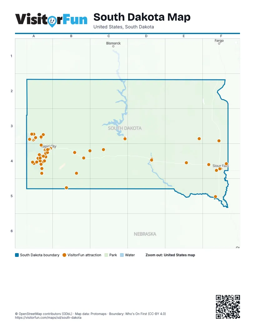
Maps inside South Dakota
10 maps inside, from the street map of South Dakota down.
Metro areas
Road map
Street index of South Dakota
Each street on the sheet and the grid squares it crosses.
- North I-29F4
- South I-29F4
- East I-90F4
- North I-229F4
- West I-90F4
- West I-229F4
- South I-229F4
- East I-229F4
- Truck InspectionF5
- REST AREA (Undeveloped)E4
- Purple Heart Memorial HighwayA3, C4, F4
- SD Highway 34A3, B3, C3, D3, D4, E4, F4
- US Highway 212A3, C3, D3, E3, F3
- US Highway 14C3, D3, E3, F3, B4, C4
- SD Highway 37E2, E3, E4, E5
- SD Highway 25E2, F2, E3, E4, E5
- SD Highway 44A4, B4, C4, D4, E4, F4
- SD Highway 20A2, C2, D3, E3, F3
- 403rd AvenueE2, E3, E4, E5
- US Highway 12C2, D2, E2, F2
- 475th AvenueF2, F3, F4, F5
- State Highway 73B2, B3, B4, C4, B5, C5
- 404th AvenueE2, E3, E4, E5
- 457th AvenueF2, F3, F4, F5
- SD Highway 50D4, E4, E5, F5
- US Highway 281E2, E3, E4, E5
- 455th AvenueF2, F3, F4, F5
- 477th AvenueF2, F3, F4, F5
- 482nd AvenueF2, F3, F4, F5
- US Highway 18A4, F4, A5, B5, D5, E5, F5
- 456th AvenueF2, F3, F4, F5
- 392nd AvenueE2, E3, E4, E5
- 386th AvenueE2, E3, E4, E5
- US Highway 81F3, F4, F5
- 481st AvenueF2, F3, F4, F5
- 244th StreetB4, D4, E4, F4
- US Highway 85A2, A3, A4
- 112th StreetC2, D2, E2, F2
- 277th StreetD4, E4, F4
- 271st StreetD4, E4, F4
- 133rd StreetD2, E2, F2, A3
- 282nd StreetC4, D4, E4, F4
- 115th StreetD2, E2, F2
- SD Highway 1806C2, C3, D3, D4, D5
- State Highway 20A2, B2, C2, D2, F3
- 268th StreetD4, E4, F4
- 240th StreetC4, D4, E4, F4
- 254th StreetD4, E4, F4
- 485th AvenueF2, F3, F4, E5, F5
- US Highway 385A3, A4, A5
- 291st StreetD5, E5, F5
- SD Highway 46E5, F5
- SD Highway 45D3, D4
- SD Highway 28E3, F3
- 161st StreetD3, E3, F3, F4
- US Highway 83D2, C3, D3, C4, C5
- 275th StreetD4, E4, F4
- 358th AvenueD2, D3, D4
- 110th StreetB2, C2, D2, E2, F2, F4
- 246th StreetA4, C4, D4, E4, F4
- 265th StreetD4, E4, F4
- State Highway 63C2, C4
- 134th StreetB2, D2, E2, F2
- Main StreetA2, B2, C2, D2, E2, F2, A3, B3, C3, D3, E3, F3, A4, B4, C4, D4, E4, F4, A5, B5, C5, D5, E5, F5
- 321st AvenueD2, D3, D4, D5
- East Highway 44A4, B4
- SD Highway 47D3, D4
- SD Highway 15F2, F3
- Blue Star Memorial Highway/Vietnam Veterans Memorial HighwayC4, C5
- SD Highway 19F4, F5
- Cecil Harris Memorial HighwayD2, D3
- 306th AvenueD2, D3, D4, D5, E5
- SD Highway 10E2, F2
- SD Highway 42E4, F4
- SD Highway 11F4, F5
- 307th AvenueD2, D3, D4, D5
- US Highway 16A4, E4
- SD Highway 79A3, A4
- 323rd AvenueD2, D3, D4, D5
- SD Highway 248B4, C4
- South Highway 79A4
- SD Highway 27E2
- 305th AvenueD2, D3, D4, D5
- Highway 16C4, D4
- Highway 1416A4, B4
- State Highway 44C4, D4
- SD Highway 127F2
- US Highway 14/34C3
- US Highway 14AA3
- 1st StreetA2, B2, C2, D2, E2, F2, A3, C3, D3, E3, F3, A4, B4, C4, D4, E4, F4, A5, B5, D5, E5, F5
- 2nd StreetB2, C2, D2, E2, F2, A3, C3, D3, E3, F3, A4, B4, C4, D4, E4, F4, A5, B5, D5, E5, F5
- SD Highway 1804C3, D4
- South Highway 16A4
- Elk Vale RoadA3, A4
- North Main StreetC2, E2, F2, A3, B3, D3, E3, F3, B4, C4, D4, E4, F4, D5, E5, F5
- Highway 385A4, A5
- 313th StreetE5, F5
- 4th StreetB2, C2, D2, E2, F2, A3, C3, D3, E3, F3, A4, B4, C4, D4, E4, F4, D5, E5, F5
- West SD Highway 50E5, F5
- 5th StreetC2, D2, E2, F2, A3, C3, D3, E3, F3, A4, C4, D4, E4, F4, A5, D5, E5, F5
- Highway 240B4
- East 4th StreetD2, E2, C3, D3, E3, F3, C4, D4, E4, F4, A5, D5, E5, F5
- South Main StreetD2, E2, F2, A3, D3, E3, F3, C4, D4, E4, F4, D5, E5, F5
- Sturgis RoadA3, A4
- 6th StreetC2, D2, E2, A3, B3, C3, D3, E3, F3, A4, C4, D4, E4, D5, E5, F5
- East 3rd StreetE2, F2, C3, D3, E3, F3, D4, E4, F4, D5, E5, F5
- Bennett AvenueA5, B5
- Highway 79A4
- East Main StreetA2, B2, D2, E2, F2, A3, E3, F3, A4, D4, E4, F4, B5, E5, F5
- South Dakota Highway 44D4
- East 2nd StreetA2, E2, F2, C3, D3, E3, F3, D4, E4, F4, D5, E5, F5
- Airport RoadA2, B2, C2, A3, C3, D3, A4, B4, C4, D4, E4, E5
- SD Highway 30F3
- West 3rd StreetA2, E2, F2, B3, C3, D3, E3, F3, D4, E4, F4, A5, D5, E5, F5
- SD Highway 262E4
- US Highway 16AA4
- West Main StreetD2, E2, F2, A3, E3, F3, A4, D4, E4, F4, B5, E5, F5
- East 5th StreetD2, E2, F2, C3, D3, E3, F3, D4, E4, F4, A5, D5, F5
- West 5th StreetE2, B3, C3, D3, E3, F3, D4, E4, F4, A5, D5, F5
- SD Highway 240B4
- West 2nd StreetA2, E2, F2, B3, C3, D3, E3, F3, D4, E4, F4, C5, D5, E5, F5
- SD Highway 73B3, B4, C4
- State Highway 10C2, D2
- US Highway 14/63C3, C4
- Pine StreetE2, F2, A3, D3, E3, A4, B4, C4, D4, E4, F4, B5, E5, F5
- 1st AvenueB2, C2, D2, E2, F2, A3, E3, F3, A4, B4, C4, D4, E4, F4, B5, D5
- West Highway 44A4
- West Highway 14A3, F3
- SD Highway 115F4
- 9th Avenue SouthwestE2, F3
- West 4th StreetE2, B3, C3, D3, E3, F3, D4, E4, F4, A5, D5, E5, F5
- Mount Rushmore RoadA4
- SD Highway 48F5
- 5th AvenueC2, D2, E2, F2, A3, B3, D3, E3, F3, A4, B4, D4, E4, F4, B5
- Broadway AvenueF2, A3, F4, F5
- Theodore Roosevelt ExpresswayA2
- Dakota Avenue SouthF2, D3, E3, F3, E4
- West 6th StreetB3, D3, E3, F3, C4, D4, E4, F4, A5, D5, F5
- East 7th StreetD2, E2, C3, D3, E3, F3, D4, E4, F4, A5, D5, F5
- South Creek RoadC4
- West 7th StreetE2, C3, D3, E3, F3, D4, E4, F4, A5, D5, E5, F5
- West 12th StreetD3, D4, F4, D5, F5
- North Cliff AvenueF4
- South Minnesota AvenueE4, F4
- 8th StreetC2, D2, E2, A3, C3, D3, F3, C4, E4, D5, E5, F5
- North 5th StreetE2, F2, A3, C3, F3, A4, E4, F4, E5, F5
- East 10th StreetD4, E4, F4, D5, F5
- SD Highway 36A4
- SD Highway 17F4
- North Veterans ParkwayF4
- South Dakota StreetE2, F2, E3, A4, E4, F4, F5
- South Louise AvenueF4
- West 41st StreetF4
- West Russell StreetF4
- North Main AvenueD4, E4, F4
- East SD Highway 50F5
- South Main AvenueD4, E4, F4
- Ash StreetE2, F2, A3, D3, E3, A4, B4, C4, F4, A5, B5, C5, E5, F5
- 1st Avenue EastB2, C2, D2, E2, F2, E3, B4
- West 4th AvenueE2, F2, B3, D3, E3, B4, C4, E4, F4, E5
- 9th Avenue SoutheastE2, F3
- 4th Street NortheastE3, F3, E4
- West 10th StreetD3, F3, D4, E4, F4, D5, F5
- East Arrowhead ParkwayF4
- SD Highway 244A4
- North Lake DriveD2, F3
- 1st Avenue WestB2, C2, D2, E2, F2, E3, B4
- East 4th AvenueE2, F2, C3, D3, E3, E4, F4, E5
- West 26th StreetF4, E5, F5
- North Minnesota AvenueE4, F4, F5
- North 2nd StreetE2, F2, A3, C3, E3, F3, A4, E4, F4, E5, F5
- East Colorado BoulevardA3
- South 2nd StreetE2, F2, C3, E3, F3, A4, E4, F4, E5, F5
- West 5th AvenueE2, F2, B3, D3, E3, B4, C4, E4, F4, E5
- South Veterans ParkwayF4
- Sylvan Lake RoadA4
- 4th Street NorthwestD3, E3, F3, E4
- West 11th StreetD4, E4, F4, D5, E5, F5
- West 31st StreetF4, E5, F5
- US Highway 16/385A4
- Catron BoulevardA4
- South Rockerville RoadA4
- North US Highway 281E2
- Spruce StreetF2, A3, C3, D3, F3, A4, D4, E4, F4, E5, F5
- North 1st StreetC2, E2, F2, C3, F3, A4, E4, F5
- South 1st StreetE2, F2, C3, F3, A4, E4, E5, F5
- Railroad AvenueD2, E2, F2, A3, F3, A4, F4, F5
- State Highway 40F3, B4
- East 6th AvenueE2, C3, D3, E3, E4, F4, E5
- East North StreetF3, A4, D4, E4, F4
- East Rice StreetF4
- North Highway 20F3
- East 7th AvenueE2, F2, C3, D3, E3, E4
- 6th Avenue SoutheastE2, E3, F3
- West Chicago StreetA4, E5
- West Benson RoadF4
- North West AvenueF4
- North Highway 14C3
- Dakota Avenue NorthD3, E3, F3, E4
- 5th Street SoutheastD3, E3, F3, E5
- State Highway 45D2, D3
- 5th Avenue NorthwestE2, E3, F3
- Peaceful Pines RoadA4
- West Elm StreetE2, F3, A4, B4, E4, F4, F5
- South Garfield AvenueC3, F4
- East Benson RoadF4
- North Garfield AvenueC3, F4
- Cambell StreetA4
- Fall River RoadA4
- South 2nd AvenueE2, F3, E4, F4, E5
- South US Highway 281E2
- East 11th StreetE3, F4, D5, F5
- Lazelle StreetA3
- South West AvenueF4
- North Ohlman StreetE4
- North AvenueD2, A3, F5
- East King StreetD4
- Highland RoadA4, F4
- West Cherry StreetF2, B4, E4, F5
- Jackson BoulevardA4
- 1st Street WestA2, B2, C2, E2, B3, E3, F3
- Sherman StreetD2, A3, A4
- Adams StreetA3, F3, A4, B4, C4, D4, F5
- Highway 244A4
- Highway 16AA4
- East Wells AvenueC3
- North BroadwayD3, F3
- North Elk Vale RoadA4
- US Highway 14 WestE3
- West 14th StreetD3, D4, F4, D5, F5
- 3rd Street NortheastE2, D3, E3, F3, E4
- West Omaha StreetA4
- East Highway 12E2
- East Cherry StreetF2, B4, F5
- Highway 37 BypassE4
- West Havens AvenueE4
- West US Highway 18E5, F5
- West 7th AvenueE2, F2, C3, E3, B4, E4, F4
- US Highway 14 EastE3
- 3rd Street NorthwestE2, D3, E3, F3, E4
- 18th StreetD2, F3
- East Havens AvenueE4
- 26th Avenue NortheastF3
- North Highland AvenueC3, F4
- West Highway 12E2
- West BoulevardA4
- South Splitrock BoulevardF4
- 10th Street SouthwestE3, F3
- West Lake DriveE2, F3, F4
- Junction AvenueA3
- 3rd Street WestA2, B2, C2, E2, D3, E3, F3
- East SD Highway 16D4
- West Veterans ParkwayF4
- Omaha StreetA3, A4, C4
- South Burr StreetE4
- Centennial DriveA4, B4, F5
- 1st Street EastA2, B2, C2, B3, D3, E3
- East Cedar StreetF4, F5
- East 11th AvenueE2, F2, D3, D4, E4, F4, E5
- South Ohlman StreetE4
- West Holly BoulevardF4
- East Catron BoulevardA4
- East Elm StreetF3, A4, B4, D4, E4, F4, F5
- West Dakota StreetC2, F2, A3, E4, F4, E5, F5
- Wind Cave RoadA4
- West 11th AvenueE2, E3, D4, E4, F4, E5
- South Broadway AvenueD3, F3, F4
- East Dakota StreetC2, D2, F2, A3, E4, E5, F5
- West Cedar StreetF5
- West North StreetA4, D4, F4
- Highway 1806C3, D4
- Southwest 3rd StreetF4
- West Grand CrossingC2
- Southeast 10th StreetF4
- Birch AvenueD3, F3, A4, D4, F4, F5
- Liberty BoulevardA4, B4
- SD Highway 204C3
- Saint Joseph StreetA4
- 5th Street NortheastE3, F3, E4, F4
- Main Street NorthD2, F2, F3
- US Highway 12 WestE2
- East Veterans ParkwayF4
- Fairview AvenueA3, F5
- US Highway 14 BypassF3
- Main Street SouthD2, E2, F2, B3
- Mountain View RoadA3, A4
- South US Highway 81F4
- West King StreetA3, D4
- 10th Street WestB2, C2, F3
- North 27th StreetA3
- 6th Avenue SouthwestE2, F3
- Terminal RoadD2, B4
- West Highway 14 BypassF3
- Highway 14 BypassF3
- North 5th AvenueE2, A3, F3, E4, F4, E5
- North Ellsworth RoadA4
- East US Highway 18E5, F5
- Northwest 2nd StreetF4
- West Jackson BoulevardA3
- 3rd Avenue SouthF3
Things to do on the South Dakota map
- 1880 Train
- Adams Museum
- Badlands National Park
- Bear Butte State Park
- Bear Country USA
- Belle Joli Winery
- Big Thunder Gold Mine
- Black Elk Peak
- Black Hills & Badlands
- Black Hills Above & Beyond Tours
- Black Hills Aerial Adventures
- Black Hills Balloons
- Black Hills Bronco Adventures
- Black Hills Caverns
- Black Hills Discovery Tours
- Black Hills Glass Blowers
- Black Hills Helicopters
- Black Hills Wilderness Edge
- Bramble Park Zoo
- Brookings County Museum
- Chapel in the Hills
- Chatku Arts Center
- Cheyenne Crossing
- Children's Museum of South Dakota
- Corn Palace
- Crazy Horse Memorial
- Custer State Park
- Custer State Park Resort
- Custer's Gulch RV Park and Campground
- D.C. Booth Historic National Fish Hatchery
- Dakota Plains Gallery & Gifts
- Deadwood
- Deadwood Alive
- Dignity of Earth and Sky
- Dinosaur Park
- Eagle Aviation
- Falls Park
- Firehouse Brewing Company
- Flags & Wheels Indoor Racing
- Fort Meade
- Four Mile Old West Town Museum
- George S. Mickelson Trail
- Gold Diggers Black Hills Gold
- Great Plains Zoo
- Hills Inn
- Hot Springs
- Ingalls Homestead
- International Vinegar Museum
- Jewel Cave National Monument
- Keystone Historical Walking Tour
- Lake Herman State Park
- Minuteman Missile National Historic Site
- Mount Moriah Cemetery
- Mount Rushmore Black Hills Gold
- Mount Rushmore Bookstores
- Mount Rushmore KOA Resort at Palmer Gulch
- Mount Rushmore National Memorial
- Museum at Black Hills Institute
- Museum of Geology
- National Music Museum
- National Presidential Wax Museum
- Needles Highway
- Oahe Dam Visitor Center
- Oakwood Lakes State Park
- Old Courthouse Museum
- Old MacDonald's Farm
- Outlaw Square
- Palisades State Park
- Pettigrew Home & Museum
- Pine Ridge Area Chamber of Commerce Visitor Center
- Pioneer Auto Show
- Porter Sculpture Park
- Prairie Edge Galleries
- Prairie Homestead Historic Site
- Putz n Glo
- Rapid City
- Redlin Art Center
- Reptile Gardens
- Rush Mountain Adventure Park
- Rushmore Borglum Story
- Rushmore Tramway Adventures
- Sanford Lab Homestake Visitor Center
- Signature Black Hills Tours
- Sioux Indian Museum
- Siouxland Heritage Museums
- South Dakota Cultural Heritage Center
- South Dakota Department of Tourism
- South Dakota's Original 1880 Town
- Southern Hills Vacation Guide
- Spearfish Canyon
- Spearfish Sasquatch
- Sprockets Fun Foundry
- Stagecoach West Tours
- Storybook Island
- Sturgis Area Chamber of Commerce & Visitors Bureau
- Sturgis Car Museum
- Sturgis Motorcycle Museum & Hall of Fame
- The Brothel Deadwood
- The Lodge at Deadwood
- The Mammoth Site
- Thunder Road Family Fun Park
- Wall
- Wall Drug Store
- Washington Pavilion of Arts and Science
- Wild Water West Waterpark
- Wind Cave National Park
- Wonderland Cave
Places on the map
- Aberdeen
- Aberdeen Township
- Angostura Recreation Area
- Badlands National Park
- Badlands Wilderness
- Bear Butte State Park
- Black Elk Wilderness
- Black Hills National Forest
- Britton Municipal Airport
- Brookings Regional Airport
- Buffalo Gap National Grassland
- Canton Municipal Airport
- Chan Gurney Municipal Airport
- Cheyenne Eagle Butte Airport
- Clyde Ice Field
- Custer State Park
- Elkhorn Ridge Golf Club
- Ellsworth Air Force Base
- Farm Island Recreation Area
- Fort Pierre National Grassland
- Grand River National Grassland
- Hart Ranch Golf Club
- Huron Regional Airport
- Jewel Cave National Monument
- Lacreek National Wildlife Refuge
- Lake Andes National Wildlife Refuge
- Lemmon Municipal Airport
- Lewis & Clark Recreation Area
- Madison Municipal Airport
- Mitchell Municipal Airport
- Mobridge Municipal Airport
- North Cave Hills
- Philip Municipal Airport
- Pine Ridge Landing Field
- Roy Lake State Park
- Samuel H Ordway Prairie Preserve
- Sand Lake National Wildlife Refuge
- Sheps Canyon Outdoor Recreation Complex
- Sutton Bay Golf Course
- Wind Cave National Park
Next to South Dakota
- Bismarck
- Fargo
© OpenStreetMap contributors, Open Database License, openstreetmap.org/copyright · Map data: Protomaps · Boundary: Who's On First (CC-BY 4.0); Quattroshapes (CC BY 2.0)