

South Dakota map
Pierre map
About 13,788 people live here (Census Bureau, 2024 estimate). The sheet's index lists 271 streets; North Highway 14, East Wells Avenue and North Garfield Avenue cross the most grid squares. Things to do inside the boundary: Oahe Dam Visitor Center, South Dakota Cultural Heritage Center and South Dakota Department of Tourism.
Open the map (PDF, US Letter)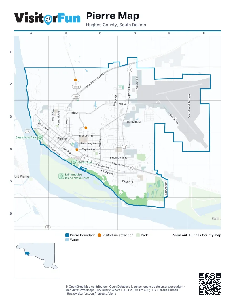
Street index of Pierre
Each street on the sheet and the grid squares it crosses.
- North Highway 14C1, D1, B2, C2, B3
- 292nd AvenueD1
- North Airport RoadD1, D2, D3
- North Garfield AvenueD1, D2, D3, D4
- US Highway 14D1
- Country DriveA2, A3
- Eagle DriveA2, A3
- River RimA2
- Riverplace DriveA2
- Riverside DriveA2
- SD Highway 1804B2
- Abbey RoadC2, C3
- Bristol PlaceC2, C3
- Brookstone LoopC2, D2
- Callaway CourtC2, D2
- Duluth AvenueC2
- Grandview AvenueC2
- Lancaster LoopC2
- Lancaster PlaceC2
- Saunders AvenueC2
- Sunrise DriveC2
- Brighton CourtD2
- Eastgate AvenueD2
- Marquette StreetD2
- Plateau StreetD2
- Southgate DriveD2
- Table StreetD2
- 293rd AvenueE2
- Abandoned RunwayF2, F3
- Cedar PlaceA3
- Edgewater DriveA3
- Hyde DriveA3
- James StreetA3
- Lakeside DriveA3
- Lakewood DriveA3
- Lee Hill RoadA3
- Maple AvenueA3
- Mellette AvenueA3
- Neltom DriveA3
- North Hathaway StreetA3
- North Maple AvenueA3
- North Willow AvenueA3, B3
- Ridgeview AvenueA3
- River RoadA3
- Sibert PlaceA3
- South Ash StreetA3
- South Charles StreetA3, A4
- South Maple AvenueA3
- South Poplar AvenueA3, B3, A4
- South Willow AvenueA3
- Spruce PlaceA3
- Terri LaneA3
- West 2nd StreetA3, B3
- West 3rd StreetA3, B3
- West 4th StreetA3, B3
- West 5th StreetA3, B3
- West 7th StreetA3, B3
- West Capitol AvenueA3, B3, B4
- West Dakota AvenueA3, A4, B4
- West Elizabeth StreetA3, B3
- West Pleasant DriveA3, B3, B4
- West Prospect AvenueA3, B3, B4
- West Sioux AvenueA3, A4, B4
- Westwood DriveA3
- Woodriver DriveA3
- Woodriver QuayA3
- Clarice DriveB3
- East 1st StreetB3
- East 2nd StreetB3
- East 3rd StreetB3
- East 4th StreetB3, C3, D3
- East 5th StreetB3
- East 6th StreetB3
- East 7th StreetB3
- East 8th StreetB3
- East Broadway AvenueB3, B4, C4
- East Elizabeth StreetB3, D3
- East Oak StreetB3
- East Seneca StreetB3
- East Wynoka StreetB3
- Governors DriveB3, C3, B4
- Labarge CourtB3
- Mary LaneB3, B4
- North Central AvenueB3, B4
- North Euclid AvenueB3, B4
- North Evans StreetB3
- North Grand AvenueB3, B4
- North Harney CourtB3
- North Highland AvenueB3, B4
- North Huron AvenueB3, B4
- North Oneida AvenueB3
- North Poplar AvenueB3
- North Sebree PlaceB3
- North Yankton AvenueB3
- Seneca StreetB3
- South Oneida AvenueB3
- South Yankton AvenueB3, B4
- West 8th StreetB3
- West Broadway AvenueB3
- West Oak StreetB3
- West Seneca StreetB3
- Willow AvenueB3
- Bluebell DriveC3
- Cambridge DriveC3
- Camden CourtC3
- Capitol Hill DriveC3
- Cherry DriveC3
- Circle DriveC3
- Currant DriveC3
- Drycreek StreetC3, D3
- Flag Mountain DriveC3, D3
- Hampton DriveC3
- Heritage DriveC3
- Hilgers DriveC3
- Kennedy DriveC3, D3
- Kennedy LoopC3
- Lilac DriveC3
- Manchester DriveC3
- North Harrison AvenueC3, D3, C4
- North Jefferson AvenueC3, C4
- North Madison AvenueC3, C4
- North Monroe AvenueC3, C4
- North Taylor AvenueC3, C4
- Pasque DriveC3, C4
- Pierce DriveC3
- Plum DriveC3
- Preston PlaceC3
- Ridgeway PlaceC3
- Riggs DriveC3
- Sheila DriveC3, D3
- Stratford PlaceC3
- Vista LoopC3
- Vista Ridge PlaceC3
- Winchester DriveC3
- Woodridge DriveC3
- Airport RoadD3, E3
- Aries AvenueD3
- Beechcraft RoadD3
- Black Hills DriveD3
- Jupiter StreetD3, E3
- Lincoln AvenueD3
- Lowell AvenueD3
- Mercury StreetD3, E3
- North Arthur AvenueD3
- Northstar AvenueD3
- Oak StreetD3
- Orion AvenueD3, E3
- Patron ParkwayD3
- Polaris AvenueD3
- Sandstone PlaceD3
- Saturn StreetD3, E3
- South Airport RoadD3, E3
- Venus StreetD3, E3
- Village DriveD3
- A StreetE3
- Cessna StreetE3
- Piper StreetE3
- Island View DriveA4, B4
- South Central AvenueA4, B4
- South Henry StreetA4, B4
- South Robert StreetA4
- West Missouri AvenueA4, B4
- Anton StreetB4
- East Cabot StreetB4, C4
- East Capitol AvenueB4, C4, D4
- East Church StreetB4, C4
- East Dakota AvenueB4, C4, C5, D5
- East Erskine StreetB4, C4, D4
- East Marina AvenueB4, C5
- East Missouri AvenueB4, B5
- East Park StreetB4, C4, C5, D5
- East Pleasant DriveB4
- East Prospect AvenueB4
- East Sioux AvenueB4, C4, C5
- East Wells AvenueB4, C4, D4, D5, E5
- High StreetB4
- Mac LaneB4
- North Nicollet AvenueB4
- North Washington AvenueB4
- Parkwood DriveB4
- South Adams AvenueB4, C4
- South Brule StreetB4
- South Chapelle StreetB4
- South Coteau StreetB4
- South Court PlaceB4
- South Crow StreetB4
- South Dakota BoulevardB4
- South Euclid AvenueB4
- South Fort StreetB4
- South Highland AvenueB4
- South Huron AvenueB4
- South Pawnee StreetB4
- South Pierre StreetB4
- South Ree StreetB4
- South Washington AvenueB4, C4, B5
- Antelope StreetC4
- BroadwayC4
- Buffalo StreetC4, D4
- Coyote StreetC4
- East Franklin StreetC4, D4
- East Humboldt StreetC4, D4
- East Irwin StreetC4, D4
- East Pine StreetC4, D4
- East Robinson AvenueC4
- East Summit AvenueC4
- Fox DriveC4
- Hilltop DriveC4
- Iris CourtC4
- Lakeview DriveC4
- North Adams AvenueC4
- North Buchanan AvenueC4, D4
- North Fir StreetC4, D4
- North Jackson AvenueC4
- North Johnson AvenueC4
- North Pierce AvenueC4
- North Robinson AvenueC4
- North Spruce AvenueC4, D4
- North Tyler AvenueC4
- North Van Buren AvenueC4
- Pierce AvenueC4
- South Buchanan AvenueC4, C5
- South Filmore AvenueC4, C5
- South Harrison AvenueC4, C5
- South Jackson AvenueC4, C5
- South Jefferson AvenueC4, C5
- South Madison AvenueC4, C5
- South Monroe AvenueC4, C5
- South Pierce AvenueC4, C5
- South Polk AvenueC4, C5
- South Taylor AvenueC4, C5
- South Tyler AvenueC4, C5
- South Van Buren AvenueC4, C5
- Summit AvenueC4
- Sunset DriveC4
- Yucca DriveC4
- Baja DriveD4
- Bulow DriveD4
- Bushfield DriveD4
- Cemetery RoadD4
- East Green StreetD4
- East Kay StreetD4
- Hemlock AvenueD4
- Herseth DriveD4
- Lakeview CourtD4
- Landfill RoadD4, E4, D5
- Norbeck DriveD4
- North Case DriveD4
- Skyline DriveD4
- South Arthur StreetD4, D5
- South Cleveland AvenueD4, D5
- South Garfield AvenueD4, D5
- South Grant AvenueD4, D5
- South Hayes AvenueD4, D5
- South Lincoln AvenueD4, C5
- South Roosevelt AvenueD4, D5
- Stanton Avenue DriveD4
- East Pawn AvenueC5, D5
- East Sully AvenueC5, D5
- East Reen StreetD5
- Industrial RoadD5
- Izaak Walton RoadD5
- Laurel LaneD5
- Memory LaneD5
- South Lowell AvenueD5
- South McKinley AvenueD5
- South Primrose LaneD5
- South Truman AvenueD5
- Vickmark RoadD5
- Fairway DriveE5
- Jane LaneE5
- Sandwedge DriveE5
Things to do on the Pierre map
Places on the map
- Advance Auto Parts
- American Legion Hall
- Anderson Dental
- Angel's Salon
- Animal Clinic of Pierre
- Arby's
- Avera Saint Mary's Hospital
- BankWest
- Baymont Pierre
- Beauty Boutique
- Beck Motor Company
- Beck Motor Company - Chevrolet/Cadillac
- Black Hills Federal Credit Union
- Buchanan School
- Buckeye Township
- Capitol Lake
- Griffin Park
- Hillsview Golf Club
- Hughes County Jail
- Hyde Baseball Stadium
- Menards
- Mickelson Fishing Pond
- Northridge Plaza Mall
- Oahe Softball Complex
- Phil Trautner Stadium
- Pierre Community Dog Park
- Pierre Indian Learning Center
- Pierre Regional Airport
- PILC Soccer Complex
- Riverside Cemetery
- South Dakota Women's Prison
- Steamboat Park
- T.F. Riggs High School
- Walmart Supercenter
Next to Pierre
- Fort Pierre
© OpenStreetMap contributors, Open Database License, openstreetmap.org/copyright · Map data: Protomaps · Boundary: Who's On First (CC-BY 4.0); U.S. Census Bureau















