

South Dakota map
Hughes County map
About 17,526 people live here (Census Bureau, 2024 estimate). The sheet's index lists 300 streets; US Highway 14, 198th Street and 196th Street cross the most grid squares. Things to do inside the boundary: Oahe Dam Visitor Center, South Dakota Cultural Heritage Center and South Dakota Department of Tourism.
Open the map (PDF, US Letter)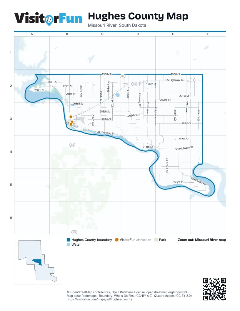
Maps inside Hughes County
1 map inside, from the street map of Hughes County down.
Street index of Hughes County
Each street on the sheet and the grid squares it crosses.
- US Highway 14C2, D2, E2, F2, B3, C3
- SD Highway 34C3, C4, D4, E4, F4
- SD Highway 1804B2, B3
- North Highway 14B3
- East Wells AvenueB3
- North Garfield AvenueB3
- US Highway 83D2
- East Sioux AvenueB3
- West Sioux AvenueB3
- North Euclid AvenueB3
- SD Highway 204B2
- South Garfield AvenueB3
- West Pierre StreetD2
- South Pierre StreetB3
- South Washington AvenueB3
- East Pierre StreetD2
- East Pleasant DriveB3
- South Euclid AvenueB3
- Airport RoadB3
- North Harrison AvenueB3
- South Harrison AvenueB3
- 198th StreetA2, B2, C2, D2, E2, F2
- 196th StreetA2, B2, C2, D2, E2, F2
- 199th StreetA2, B2, C2, D2, E2
- 206th StreetB3, C3, D3, E3
- 318th AvenueE2, E3, E4
- 321st AvenueE2, E3, E4
- 208th StreetC3, D3, E3, F3
- Canning RoadD2, D3, D4
- 311th AvenueD2, D3, D4
- Westbend RoadE4, E5, F5
- 204th StreetB3, C3, D3, E3, F3
- 322nd AvenueF2, F3, F4
- 299th AvenueC2, C3
- 212th StreetE4, F4
- 302nd AvenueC2, C3
- 324th AvenueF2, F3, F5
- 314th AvenueE2, E3, E5
- 306th AvenueD2, D3
- 313th AvenueE2, E3
- 310th AvenueD2, D3, D4
- 296th AvenueC2, C3
- Joe Creek RoadE4, E5
- Grey Goose RoadB2, B3
- 223rd StreetE5, F5
- 207th StreetC3, D3, E3
- 301st AvenueC2, C3
- Chapelle RoadE3, E4
- 323rd AvenueF2, F5
- 219th StreetE4
- 288th AvenueB2
- 294th AvenueC2, C3
- Dunbar RoadD4
- Nystrom RoadC3
- 214th StreetD4
- Chesley RoadD3
- Rocky RoadD2
- East 4th StreetE2, B3
- East Dakota AvenueB3
- 225th StreetF5
- East Capitol AvenueB3
- Farm Island RoadB3, C3
- East Park StreetB3
- East Broadway AvenueB3
- 326th AvenueF5
- West Capitol AvenueB3
- Governors DriveB3
- 224th StreetF5
- South Poplar AvenueB3
- East Church StreetB3
- West 5th StreetE2, B3
- North Main StreetD2
- North Highland AvenueB3
- West Dakota AvenueB3
- North Lone Tree StreetD2
- South Wyman StreetE2
- South Central AvenueB3
- South Lowell AvenueB3
- South Highland AvenueB3
- South Lone Tree StreetD2
- North Nicollet AvenueB3
- East Lydia AvenueD2
- PowerHouse RoadB2
- West Washington StreetD2
- 200th StreetA2, B2, C2, D2, E2, F2
- 205th StreetB3, C3, D3, E3
- 201st StreetB2, C2, E2, F2
- 202nd StreetB2, C2, D2, E2, F2
- 203rd StreetB3, C3, D3, F3
- 303rd AvenueC2, C3
- 300th AvenueC2, C3
- 293rd AvenueB2, B3
- 316th AvenueE2, E3, E4, E5
- 320th AvenueE2, E5
- 197th StreetB2, C2, D2
- 319th AvenueE2
- 292nd AvenueB2, B3
- Holly RoadB2
- Chaney Rush RoadF4
- Runge RoadD2
- 315th AvenueE2, E3
- 304th AvenueD2, D3
- 295th AvenueC3
- Clark RoadC3, D3, D4
- 291st AvenueB2
- 287th AvenueB2
- 325th AvenueF2, F3
- Medicine Creek RoadD3, D4
- 307th AvenueD2, D3
- 312th AvenueD2, D3
- 285th AvenueB2
- 209th StreetD3, F3
- 218th StreetE4
- 210th StreetD3, E3
- 221st StreetE5
- 317th AvenueE2
- 309th AvenueD2, D3
- Valley RoadF5
- Peoria PlaceB2
- East Sully AvenueB3
- 283rd AvenueA2
- Tree Farm RoadB2
- Nachtigal RoadE5
- Shady PlaceC3
- North Airport RoadB3
- Landfill RoadB3
- East Erskine StreetB3
- Dry Run RoadC3
- Sunflower PlaceC2, C3
- Abandoned RunwayB3
- Gustafson RoadE3
- East Franklin StreetB3
- 282nd AvenueA2
- Cottonwood PlaceC2
- Dixon RoadD3
- Hyde RoadB2
- 220th StreetE5
- West 3rd StreetE2, B3
- Cottage PlaceD4
- West 2nd StreetE2, B3
- North Grand AvenueB3
- 297th AvenueC2, C3
- West Pleasant DriveB3
- East Missouri AvenueB3
- North Huron AvenueB3
- 308th AvenueD4
- East Humboldt StreetB3
- East Elizabeth StreetB3
- West Elizabeth StreetB3
- North Central AvenueB3
- Oahe Lake PlaceA2
- Flag Mountain DriveB3
- Mush Creek PlaceC3
- Sunshine LoopB2
- Carmody RoadE4
- 279th AvenueA2
- Buhl AvenueB3
- Raccoon RoadD2
- Western RoadB2
- North Bluff StreetD2
- Catfish PlaceD4
- Royal Ridge RoadC3
- Shoreline StreetA2, B2
- Williams StreetB3
- 305th AvenueD2, D3
- North Hughes StreetD2
- North Monroe AvenueB3
- East Cabot StreetB3
- Sussex RoadB3
- South Buchanan AvenueB3
- South Airport RoadB3
- North Poplar AvenueB3
- North Oneida AvenueB3
- 211th StreetD3
- North Taylor AvenueB3
- Stewart PlaceB2
- Abbey RoadB3
- East Canal DriveA2
- Shamrock AvenueB3
- 213th StreetD4
- East Spring Creek DriveA2
- Country DriveB3
- Brookstone LoopB3
- North Madison AvenueB3
- East Irwin StreetB3
- West 4th StreetE2, B3
- Island View DriveB3
- South Taylor AvenueB3
- 280th AvenueA2
- Essex RoadB3
- South Filmore AvenueB3
- West Prospect AvenueB3
- Mint RoadF5
- South Polk AvenueB3
- Lakeview PlaceC3
- Northstar AvenueB3
- South Pierce AvenueB3
- Clover RoadB2
- Marble RoadC3
- 286th AvenueB2
- Cemetary RoadE2
- Winchester DriveB3
- Regent PlaceB3
- West Adams StreetD2
- Sleigh RoadB2
- North Jackson AvenueB3
- Duluth AvenueB3
- North Jefferson AvenueB3
- East 5th StreetE2, B3
- East Reen StreetB3
- Meadowlark RoadB2
- North Commercial StreetD2
- Canvasback RoadC3
- South Grant AvenueB3
- South Cleveland AvenueB3
- Woodruff PlaceE2
- South Monroe AvenueB3
- Rockford RoadB2
- Linnell StreetA2
- Buffalo StreetB3
- South Tyler AvenueB3
- Joann RoadB2
- South Ree StreetB3
- North Tyler AvenueB3
- North Ree StreetD2
- Fairway DriveB3
- Merry RoadB2
- U.P.S. RoadB3
- West 7th StreetB3
- Lonesome PlaceE5
- MIca PlaceC3
- North Van Buren AvenueB3
- West Missouri AvenueB3
- South Madison AvenueB3
- East Robinson AvenueB3
- West Newberry AvenueD2
- South Van Buren AvenueB3
- South Jefferson AvenueB3
- Cedar CourtC3
- Green Grass RoadB3
- Windsor PlaceB3
- South Lincoln AvenueB3
- South Nixon StreetE2
- East 2nd StreetE2, B3
- Orion AvenueB3
- South Arthur StreetB3
- East 1st StreetE2, B3
- Polaris AvenueB3
- South Jackson AvenueB3
- Pinto PlaceC3
- Honeylocust StreetB2
- Ponderosa StreetB2
- Cemetery RoadB3
- Vista LoopB3
- Lakeside RoadC3
- South Eastman AvenueE2
- Cliff Side RoadC3
- Hampton DriveB3
- East Pawn AvenueB3
- Cactus Loop RoadD3
- North Pierce AvenueB3
- North Canford StreetD2
- East 3rd StreetE2, B3
- Blackbird RoadB2
- Bushfield DriveB3
- Quail RoadB2
- Browning RoadB3
- Plainsview RoadB3
- North Buchanan AvenueB3
- South Roosevelt AvenueB3
- South Adams AvenueB3
- North Evans StreetB3
- Sandwedge DriveB3
- Prairie PlaceB3
- Edgewater DriveB3
- Callaway CourtB3
- Nutmeg PlaceC3
- North Arthur AvenueB3
- Evergreen StreetB2
- North Spruce AvenueB3
- West Butte AvenueD2
- South Cavanaugh AvenueE2
- Saunders AvenueB3
- Millenium AvenueB2
- North Johnson AvenueB3
- Whitetail AvenueB3
- North Willow AvenueB3
- Cattail PlaceC3
- East Summit AvenueB3
- North Prairie StreetD2
- Walleye DriveA2
- Sturgeon RoadD4
- East Railroad StreetE2
- Landing AvenueA2
- Venus StreetB3
- North Maple AvenueB3
- Ridgeview AvenueB3
- Eastgate AvenueB3
- North Freeland StreetD2
- Riverside DriveB3
Things to do on the Hughes County map
Places on the map
- Big Bend District
- Blunt
- Blunt Cemetery
- Blunt Township
- Bretton Township
- Buckeye 10 GPA
- Buckeye Township
- Byron Township
- Canning Township
- De Grey Township
- Dry Run 20 Game Production Area
- Dry Run Township
- Farm Island Recreation Area
- Griffin Park
- Gutenkauf Game Production Area
- Harrold
- Harrold Municipal Airport
- Harrold Township
- Hillsview Golf Club
- Hyde WPA
- Joe Creek Lakeside Use Area
- Joe Creek Township
- LaFramboise Island Nature Area
- Logan Township
- Mentor Township
- Northridge Plaza Mall
- Oahe Acres
- Oahe Softball Complex
- Paradise Valley Township
- Peoria Township
- Pierre
- Pleasant Valley Township
- Raber Township
- Rousseau Township
- Snake Butte Township
- South Dakota Women's Prison
- Spring Creek Recreation Area
- Valley Township
- Webster Township
- West Bend Recreation Area
Next to Hughes County
- Fort Pierre
© OpenStreetMap contributors, Open Database License, openstreetmap.org/copyright · Map data: Protomaps · Boundary: Who's On First (CC-BY 4.0); Quattroshapes (CC BY 2.0)















