

South Dakota map
Southwest Meade UT map
About 11,332 people live here (Census Bureau, 2024 estimate). The sheet's index lists 300 streets; Sturgis Road, Tilford Road and Elk Vale Road cross the most grid squares. Things to do inside the boundary: Bear Butte State Park, Fort Meade and Wonderland Cave.
Open the map (PDF, US Letter)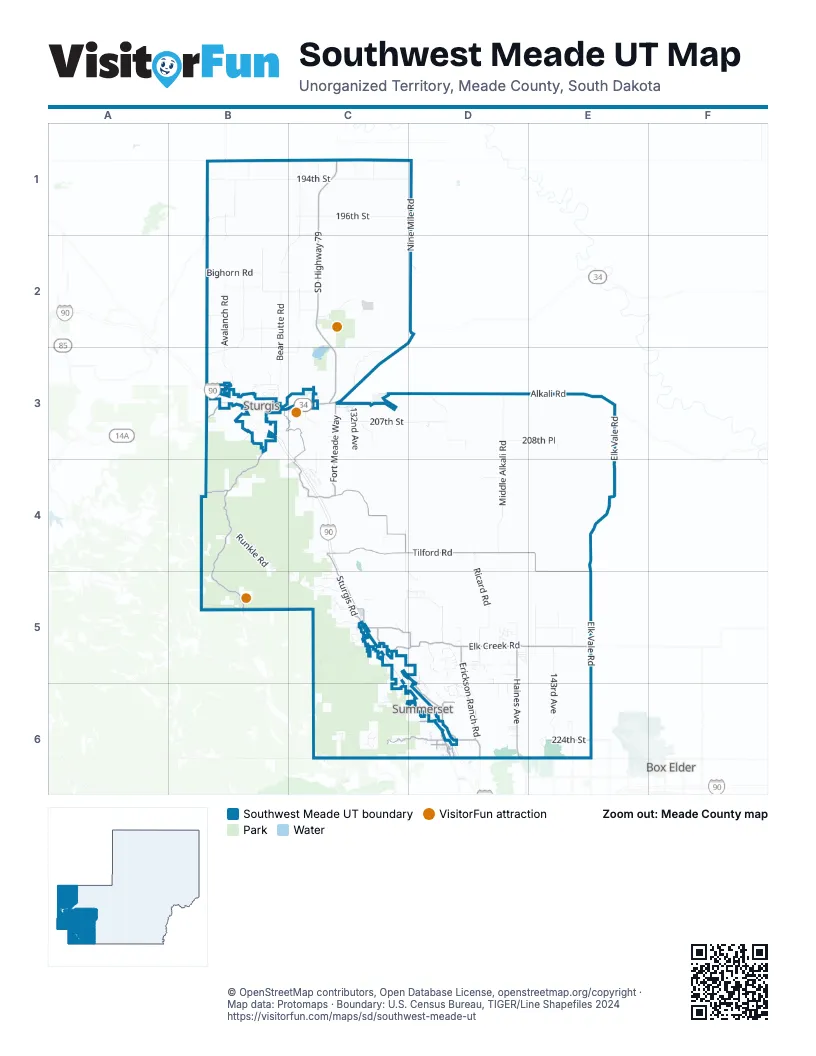
Street index of Southwest Meade UT
Each street on the sheet and the grid squares it crosses.
- SD Highway 79C1, C2, C3
- Sturgis RoadB3, C3, C4, C5, D6
- Peaceful Pines RoadC6, D6
- SD Highway 34B3, C3
- Boulder Canyon RoadB3
- Lazelle StreetB3
- Tilford RoadC4, D4, E4, E5
- Deerview RoadC5, D5
- Nemo RoadC6
- Elk Vale RoadE3, E4, E5, E6
- Elk Creek RoadC5, D5, E5
- Vanocker Canyon RoadB3, B4, B5
- Alkali RoadC3, D3, E3
- Pleasant Valley RoadC4
- Haines AvenueD5, D6
- Erickson Ranch RoadD5, D6
- Fort Meade WayC3, C4
- Horse Soldier RoadB3, C3, C4
- Whitewood Valley RoadB1
- Sidney Stage RoadC5
- 224th StreetE6
- Norman AvenueD6
- Pleasant Valley DriveC4
- Quaal RoadD6
- Woodland DriveC6
- Galena RoadB4
- Black Hawk RoadD6
- Deadwood AvenueD6
- Spring Valley RoadC5
- Captain Soelzer StreetD6
- West Elm StreetD6
- Anderson RoadD6
- West Elmwood DriveD6
- Old Whitewood RoadB3
- Seeaire DriveD6
- Stage Stop RoadD6
- Moose DriveB3
- Foothill DriveC5
- Meadow Rose LaneD6
- 2nd StreetC3, C5
- Pengra LaneD6
- Grandview DriveC5
- Prairie Violet LaneD6
- Chestnut StreetC5
- Prairie Violet Lane / Cedar StreetD6
- Bear Butte RoadC1, B2, C2, B3
- 194th StreetB1, C1, D1
- Middle Alkali RoadD3, D4
- Nine Mile RoadD1, D2
- 196th StreetB1, C1, D1
- Bighorn RoadB2, C2
- Avalanch RoadB2, B3
- 207th StreetC3, D3
- Ricard RoadD4, D5
- 143rd AvenueE3, E5, E6
- Bethlehem RoadB4, B5, C5
- Eden RoadB2, B3
- Forestry Road 144C5, C6
- 201st StreetB2, C2
- 132nd AvenueC1, C3
- Runkle RoadB4
- Gravel RoadC3
- Frontier LoopC5, D5
- 127th AvenueB2, B3
- 208th PlaceD3, E3
- Bear Butte Lake RoadC2, B3, C3
- Stagebarn Canyon RoadC5, C6
- Rolling Hills RoadC6
- Dyess AvenueE6
- Edgewood PlaceD5
- 218th StreetD5, E5
- Titan RoadD3
- 193rd StreetC1
- Lofty Pines RoadD6
- Apple RoadB1
- Kelley Spur RoadB5
- 129th PlaceC2
- 200th StreetB2
- Timberwood DriveD5
- McIntosh RoadC5
- Main StreetC3, C5, D6
- Morris Creek PlaceC4, C5, D5
- Alpine RoadB5
- Meadow Retreat RoadD5
- High Meadows DriveC6, D6
- 130th AvenueC1, C4
- Blucksberg DriveC4
- 220th StreetD5
- 126th PlaceB2
- Piedmont Meadows RoadC5
- Canyon PlaceC6
- Sunshine Valley RoadD5
- Peterson RoadD6
- Little Elk Creek RoadC5
- Foothills RoadB3
- 126th AvenueB2
- 142nd AvenueE5
- 125th AvenueB1, B2
- Ridgeview TrailD5
- Oak Ridge RoadC3
- Almond RoadB1
- Cypress PlaceC3
- Custer AvenueB3, C3
- Homer Smith RoadC5
- Bear Butte State ParkC2, C3
- 141st PlaceD5
- North Wild Turkey DriveB3
- Terry RoadB3, C3
- Buffalo RoadC3, C4
- Valley View DriveC4, C5, D6
- South Blucksberg Mountain RoadC4
- 139th PlaceD5
- 144th AvenueE5
- 199th StreetB2, C2, D2
- 203rd StreetB2, B3
- 197th StreetC1
- West Nike RoadE6
- 133rd AvenueC1
- Empire PlaceD5
- Timberline RoadD6
- Domino PlaceC5
- Mountain Shadow DriveC5
- Eastridge Hill DriveD6
- Old Stone RoadB3
- South High Meadows DriveC6
- Sage Stone DriveD5
- Lincoln Tarken LaneC5
- 210th PlaceD4
- Galaxy RoadE5
- Single Tree DriveD5
- Eastridge RoadD5, D6
- Comanche RoadC3
- Riata LoopD5
- Canyon TrailD5
- Lazy S DriveB3
- Husker PlaceD5
- North Ox Yoke RoadB3
- Diamond RoadD3
- Alder PlaceB3
- Westridge RoadD6
- PRAIRIE SCHOONER LANED5
- North Blucksberg Mountain RoadC4
- Coyote LaneE5
- Double Tree DriveD5
- Pioneer TrailE6
- Clover PlaceC4
- Crooked Canyon RoadD6
- Hale RoadD6
- Rockey RoadD5
- High Valley DriveD6
- Harp RoadC4
- Roth RoadB3
- Bulldog Canyon RoadC4
- 137th AvenueD3
- Bighorn LoopC5
- Holloway RoadB4
- Pine StreetC4, D6
- High Plains PlaceC5
- Feather PlaceD6
- Ridgeview DriveD6
- Deadman Canyon RoadB3
- Forest PlaceD5, D6
- Ash StreetB3, D6
- Willow Wood RoadD5
- Golden Valley LaneD5
- Truman RoadD5, D6
- Daisy DriveD6
- Sheridan StreetC3
- Virginia LaneD6
- Rosilee LaneD6
- Running Deer TrailD5
- Harvest LaneD5
- 15th StreetB3
- Reno RoadC3
- Wagonbox RoadB2
- Big Elk DriveC5
- Ridge TrailC4
- Snyder Ranch RoadC4
- Chimney Canyon RoadC5
- STAGECOACH LANED5
- Aigner RoadD6
- Wagon Train LaneD5
- Chimpmunk PlaceC6
- South Blucksberg DriveC4
- Witty CourtD5
- North High Meadows DriveC6
- Cattail PlaceC3
- Hillsview DriveC5
- Fountain PlaceD6
- Conestoga LoopD5
- Pine Canyon RoadC6, D6
- Dolan Creek RoadB3
- Cliff DriveC5
- White Tail DriveB3
- Echo Valley CourtC6
- Short Track RoadB3
- Stone Tree CourtD6
- Custer StreetC4, D6
- Blucksberg Mountain RoadC4
- South Ridge TrailC4
- Crooked Oaks RoadD6
- Glencoe DriveC3
- Northdale DriveD6
- Red Cedar RoadD5
- Eagle RoadC3
- La Rue RoadD5, D6
- Treasure Coach RoadD5
- Latigo LaneD5
- Ranch Valley DriveD3
- Diamond T CircleD6
- Timber Creek DriveD5
- Heritage DriveD6
- Wagon Master WayD5
- 6th StreetC3
- Kimberly DriveD6
- Emerald Heights RoadD6
- Creekside View LaneD6
- Harley LaneD6
- Eagle Ridge RoadC5
- Green Meadows DriveD5
- Lance LaneC5
- Dickson DriveB3
- North Ponderosa DriveD6
- Bear Butte CampgroundC2, C3
- Country West PlaceD5
- Logan StreetD6
- Blucksberg CourtC4
- Meadow View CourtC6
- Midland RoadC6
- Larene DriveD5
- Exit RoadC3
- Lark LaneC6
- West Valley View DriveC5
- 197rd StreetC1, D1
- South Shower RoadC3
- Brimstone PlaceC4
- Shadowland RoadD6
- Eagle Ridge TrailD5
- 138th AvenueD3
- 4th StreetC3
- South Wild Turkey DriveB3
- Brookside LaneD5
- Hilltop DriveC5
- Beverly DriveD6
- Canyon SpurD5
- Centennial Trail #89B3
- Cedar StreetD6
- Ruby RoadD5, D6
- Niche RoadD6
- Nothwood DriveD5
- Doris DriveD5
- Romel DriveD6
- Stage Hill RoadC3
- Elk Creek Village RoadC5
- Rodayo DriveC5
- Grandview TerraceC5
- Flag AvenueC3
- Hooker Canyon RoadC6
- Heidgerken RoadE6
- 3rd StreetC3
- Jay StreetC3
- Aldren LaneD6
- Three Flags LaneD6
- Ibex StreetC3
- Renata DriveD5, D6
- Wedgewood DriveD6
- Hen StreetC3
- Gar StreetC3
- Quarry RoadD6
- Still DriveB4
- Fox StreetC3
- Haas LaneD6
- Dog StreetC3
- Eel StreetC3
- Elk Creek SpurD5
- Pinewood CourtC6
- Leonard Burch DriveC5
- Cat StreetC3
- Chickadee LaneC6
- Angus LaneD6
- Terra CourtD6
- Carol CourtD6
- Crazy Horse North StreetC3
- Valles RoadD6
- Palmer LaneD6
- Bug StreetC3
- Robinson RoadD5
- 135th AvenueC4
- Madison TrailC6
- Country View PlaceD6
- Veterans RoadC3
- Chicory LaneC6
- Russ Brown BoulevardC3
- Drive RoadC3
- Deer Meadow RoadC5
- Larene CircleD5
- Spring Valley CourtC5
- Crazy Horse South StreetC3
- Center StreetC3, D6
- Creek DriveD6
Things to do on the Southwest Meade UT map
Places on the map
- Alkali Creek Campground
- Bald Mountain
- Bear Butte
- Bear Butte Campground
- Bear Butte National Wildlife Refuge
- Bear Butte Reservoir
- Bear Butte State Park
- Benoit School
- Big Bottom School
- Black Hawk
- Black Hawk Elementary School
- Black Hills National Cemetery
- Blackhawk Cemetery
- Blucksberg Mountain
- Bruch Airfield
- Bruch Ranch Airport
- Buffalo Chip Town Hall / Campground Office
- Canteen
- Columbarium A
- Columbarium B
- Columbarium C
- Committal Shelter
- Deadman Mountain
- Deep Lake
- Finding Nemo
- Flagstaff Mountain
- Fort Meade National Cemetery
- Infinity Landing Airport
- Iron Horse Campground
- No Name City Luxury Cabins & RV, LLC
- Oyster Mountain
- Piedmont Butte
- RC ACES (RC Airstrip)
- Ride N Rest Campground
- Sly Hill
- Sturgis Dragway
- Sturgis Reservoirs
- Summerset
- VA Black Hills Health Care System
- Wonderland Homes
Next to Southwest Meade UT
- Box Elder
- Deadwood
- Sturgis
- Summerset
© OpenStreetMap contributors, Open Database License, openstreetmap.org/copyright · Map data: Protomaps · Boundary: U.S. Census Bureau, TIGER/Line Shapefiles 2024















