

South Dakota map
Meade County map
About 30,918 people live here (Census Bureau, 2024 estimate). The sheet's index lists 300 streets; SD Highway 34, 196th Street and Sturgis Road cross the most grid squares. Things to do inside the boundary: Bear Butte State Park, Black Hills Above & Beyond Tours and Fort Meade.
Open the map (PDF, US Letter)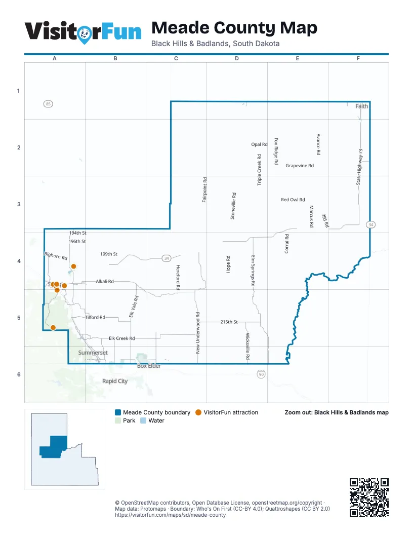
Maps inside Meade County
1 map inside, from the street map of Meade County down.
Street index of Meade County
Each street on the sheet and the grid squares it crosses.
- SD Highway 34E3, F3, A4, B4, C4, D4, E4
- State Highway 73F1, F2, F3
- Sturgis RoadA4, A5, B5, B6
- SD Highway 79A3, A4
- Peaceful Pines RoadB6
- Lazelle StreetA4
- Junction AvenueA4, A5
- Boulder Canyon RoadA4
- West 5th AvenueF1
- 1st Street EastF1
- 5th AvenueF1
- Faith BF1
- 1st Street WestF1
- Elk Creek RoadA5, B5, C5
- Tilford RoadA5, B5
- Deerview RoadA5, B5
- Stage Stop RoadB6
- Nemo RoadA6
- Elm Springs RoadD4, D5, E5, E6
- Alkali RoadA4, B4, B5, C5
- New Underwood RoadC4, C5, C6
- Elk Vale RoadB4, B5, B6
- 215th StreetC5, D5
- Vanocker Canyon RoadA4, A5
- Wicksville RoadD5, D6
- Pleasant Valley RoadA5, B5
- Avalanch RoadA4
- Antelope Creek RoadC5, C6
- Haines AvenueB5, B6
- 224th StreetB6, C6
- Erickson Ranch RoadB5, B6
- Fort Meade WayA4, A5
- Horse Soldier RoadA4, A5
- Whitewood Valley RoadA3, A4
- Main StreetE3, A4, A5, B6
- Norman AvenueB6
- Sidney Stage RoadA5
- Pleasant Valley DriveA5
- Red Scaffold RoadF2
- Moose DriveA4, A5
- Woodland DriveA4, A6, B6
- Quaal RoadB6
- Old Whitewood RoadA4
- Spring Valley RoadA5
- Galena RoadA5
- Black Hawk RoadB6
- Bixby RoadD1
- Ballpark RoadA4
- Deadwood AvenueB6
- Sherman StreetA4
- North Main StreetF1
- Dolan Creek RoadA4
- Bennett RoadB6
- Captain Soelzer StreetB6
- Dickson DriveA5
- 2nd StreetA4, A5
- West Elm StreetB6
- Otter RoadA5
- Anderson RoadB6
- West Elmwood DriveB6
- Bellingham DriveB6
- Main Street SouthF1
- Seeaire DriveB6
- Foothill DriveA5
- Arrowhead RoadF1
- Manchester StreetB6
- Siouxland RoadB6
- Grandview DriveA5
- Leisure LaneB6
- Meadow Rose LaneB6
- Chestnut StreetA5
- 5th StreetA4
- 20th StreetA4
- Pengra LaneB6
- BIA Highway 6F2
- Prairie Violet LaneB6
- Racoon RoadA5
- North Elk Vale RoadB6
- Prairie Violet Lane / Cedar StreetB6
- Stoneville RoadD1, D2, D3, D4
- Fairpoint RoadC2, D2, C3, C4
- Red Owl RoadD3, E3, D4
- Fox Ridge RoadE1, E2, E3
- Avance RoadE1, E2, E3
- Opal RoadD2, E2
- Hay Draw RoadC4, D4, D5
- Hope RoadC4, D4, D5
- 194th StreetA4, B4, D4
- Old Marcus RoadE3, F3
- Sulphur Cut Off RoadC2, D2
- Bear Butte RoadA3, A4
- Dalzell RoadD5, E5
- Plainview RoadF3, F4
- Old Stoneville RoadC3, D3
- Triple Creek RoadD2, D3
- 196th StreetA4, B4, C4, D4, E4
- Marcus RoadE2, E3, E4
- Old US Highway 212C1, C2
- Brushy Creek RoadE2, F2
- Curlew RoadC5, D5
- Chalk Butte RoadC3, D3
- Maurine RoadD1, D2
- 199th StreetA4, B4
- Nine Mile RoadB3, B4
- Hereford RoadC4, C5
- Grapevine RoadE2
- 143rd AvenueB4, B5, B6
- Middle Alkali RoadB4, B5
- Corral RoadE3, E4
- Ranch RoadD4, E4
- United School RoadE2, F2
- West Fairpoint RoadC3
- Smithville RoadD5, E5
- Bighorn RoadA4
- Ball Field RoadD4
- Red Top RoadC6, D6
- Angell RoadD6, E6
- Sycamore RoadD4, E4
- Cross S RoadC4, C5
- 207th StreetA4, B4
- Winter RoadE2, E3, F3
- Ricard RoadB5
- Rocky Knoll RoadD5, D6
- Horseshoe RoadB5, C5, B6
- Bonieta RoadD4, E4
- Owl Creek RoadE3
- Indian Creek RoadD3
- Bethlehem RoadA5
- 139th AvenueB3, B4
- Forestry Road 144A5, A6
- 219th StreetA5, C5, D5
- Eden RoadA4
- Upper White Owl RoadD3
- River RoadD5, E5
- 39S RoadE3
- 140th AvenueB4
- Four Corners RoadF3, F4
- County Highway Mc-30F2
- Tama RoadD2, E2, E3
- 150th AvenueC5, C6
- 201st StreetA4, B4
- Brehm RoadC5, C6
- Killdeer RoadC2
- 132nd AvenueA3, A4, A5
- Oxbow PlaceD4, D5
- 220th StreetB5, C5, D5
- Lakeside RoadD6
- Runkle RoadA5
- Gravel RoadA4
- 142nd AvenueB4, B5
- Laredo PlaceC4
- ScottB6, C6
- Wetz RoadB4
- Antelope RoadF3
- Juniper PlaceC4
- Tisdale RoadD6
- Frontier LoopB5
- Tidewater RoadE3
- 145th AvenueB4
- Whitetail DriveE3, A5
- Mud Butte RoadC1
- Pine Creek RoadD2, E2
- 208th PlaceB5, C5
- 176th AvenueD3, D4, D5
- 200th StreetA4, B4
- 127th AvenueA4
- Bear Butte Lake RoadA4
- 193rd StreetA3
- Stagebarn Canyon RoadA5, B5, A6
- Spring Creek RoadD3
- Twilight PlaceE2
- Cherry Creek RoadE3
- 4 Mile RoadB4
- Mule Deer DriveE5
- Rolling Hills RoadA6
- Minnehaha PlaceC3
- Pioneer RoadC6
- 165th AvenueD1, D6
- Pleasant View RoadD3
- 137th AvenueB3, B4, B5
- Dyess AvenueB6
- Edgewood PlaceB5
- 218th StreetB5
- Titan RoadB4, B5
- Poverty PinnaclesD2
- Keyhole RoadC1, C2
- Eagle Township RoadD1
- Brustel RoadD5
- 141st AvenueB4
- Star Ranch RoadC5
- Torchlight PlaceE4
- 196th PlaceF1
- Zeona RoadC1
- 169th AvenueD3, D6
- Hermit RoadD2
- Schell DriveD5
- KenneyB6
- Lone Tree RoadB5
- 209th StreetC5
- 179th PlaceF3, E4
- 194th PlaceF1
- 173rd StreetF2
- QuesadaB6
- 174th StreetE2, F2
- 224th PlaceC6
- 180th StreetF2
- Lofty Pines RoadB6
- Apple RoadA4
- 163rd StreetE1
- 172nd AvenueD3, D4
- Niagra PlaceD5
- Kelley Spur RoadA5
- Wurnig RoadC5
- Simonville RoadD6
- Linn RoadE5
- 129th PlaceA4
- Lemay BoulevardB6, C6
- Rodney RoadC4, C5
- Upland PlaceE4
- 167th PalceD4
- Ollie DriveD2
- Timberwood DriveB5
- McIntosh RoadB5
- Yachting LoopF1
- Morris Creek PlaceB5
- High Meadows DriveA6, B6
- 219th PlaceD5
- Alpine RoadA5
- Atall RoadC3, D3
- Jasmine PlaceC5
- Upsala PlaceE3, E4
- Meadow Retreat RoadB5
- 166th PlaceD4
- 210th PlaceB5, C5
- Royal RunC5
- BergstromB6
- 186th PlaceD3
- 130th AvenueA3, A4, A5
- Blucksberg DriveA5
- Almond RoadA3, A4
- Quartize PlaceD2
- 151st AvenueC5
- Lemmon Butte RoadE2
- 217th StreetC5, D5
- 126th PlaceA4
- Piedmont Meadows RoadA5
- CastleB6
- Canyon PlaceA6
- Wagon RoadE1, F1
- Sunshine Valley RoadB5
- Pine StreetA4, A5, B6
- Riverside PlaceD4
- Vista PlaceE4, F4
- Wilcox RoadC4
- Omega PlaceD4
- 164th StreetF1
- 201st PlaceD4
- Peterson RoadB6
- Little Elk Creek RoadA5
- 178th PlaceE2
- 178th AvenueE1, D5
- Centennial DriveB6, C6
- 202nd PlaceD4
- 194th AvenueF1
- Foothills RoadA4
- 126th AvenueA4
- Staple Diamond RoadF4
- 125th AvenueA4
- Deep Creek RoadE1
- 171st AvenueD4, D6
- Wilburn LaneE5
- Ridgeview TrailB5
- 146th AvenueB4
- Cedar Canyon RoadD1
- Saddle RoadB6
- Oak Ridge RoadA4, A5
- 136th PlaceB4
- Tifft RoadD4
- Lily Creek RoadD1
- 205th StreetD4
- School RoadB6
- Tower RoadE1
- Stomprud RoadD1
- Cypress PlaceA4
- Custer AvenueA4
- Tamarack PlaceE3
- Sage PlaceE3, E4
- Echo RoadB3, B4
- Homer Smith RoadA5
- Cottonwood RoadE1
- Ellsworth StreetB6
- Kentucky PlaceC2
- Foxum RoadD3
- 165th StreetF1
- Mountain Shadow DriveA5
- Bear Butte State ParkA4
- Dubb DriveD2
- Hilton PlaceB4
- 3M RoadD4
- Morning Sun PlaceC3
Things to do on the Meade County map
Places on the map
- Bald Mountain
- Barber Airport
- Bear Butte
- Bear Butte Campground
- Bear Butte Cemetery
- Bear Butte Reservoir
- Bear Butte State Park
- Black Hawk
- Black Hawk Elementary School
- Black Hills National Cemetery
- Blucksberg Mountain
- Bruch Airfield
- Buffalo Chip
- Days End Campground
- Dupree Lake
- Ellsworth Air Force Base
- Enning
- Faith
- Faith Livestock Auction
- Faith Municipal Airport
- Finding Nemo
- Iron Horse Campground
- Long Range Bay
- Maurine Lake
- Opal Lake
- Pete Lien & Sons Shooting Sports Complex
- Piedmont
- Ride N Rest Campground
- Stagebarn Middle School
- Stoneville Lake
- Sturgis
- Sturgis Brown High School
- Sturgis Dragway
- Sturgis Municipal Airport
- Summerset
- Union Center
- White Owl
- White Owl Lake
- Wilson Lake
- Wonderland Homes
Next to Meade County
- Box Elder
- Rapid City map
© OpenStreetMap contributors, Open Database License, openstreetmap.org/copyright · Map data: Protomaps · Boundary: Who's On First (CC-BY 4.0); Quattroshapes (CC BY 2.0)















