

South Dakota map
Spearfish map
About 13,803 people live here (Census Bureau, 2024 estimate). The sheet's index lists 300 streets; East Colorado Boulevard, US Highway 85 and North 27th Street cross the most grid squares. Things to do inside the boundary: Eagle Aviation, D.C. Booth Historic National Fish Hatchery and Spearfish Sasquatch.
Open the map (PDF, US Letter)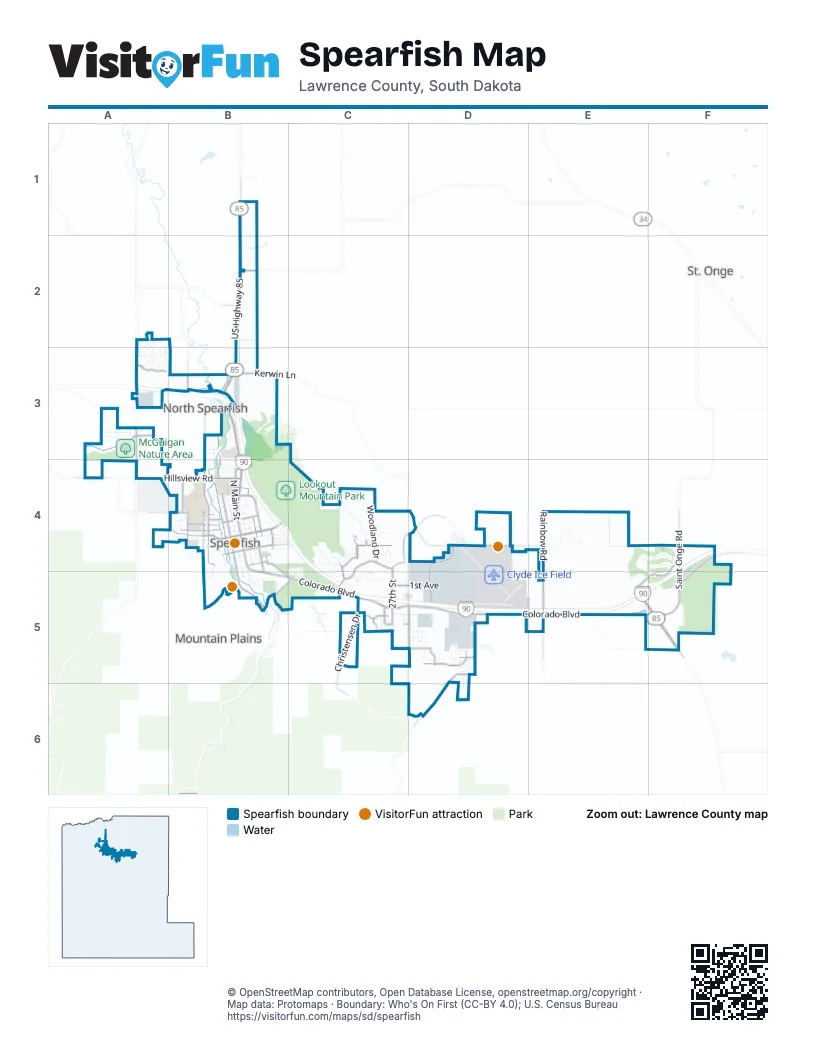
Street index of Spearfish
Each street on the sheet and the grid squares it crosses.
- Purple Heart Memorial HighwayE5
- East Colorado BoulevardB4, B5, C5, D5, E5, F5
- US Highway 85B1, B2, B3, E5, F5
- North AvenueB3, B4
- North 27th StreetC4, D4, C5
- North Main StreetB4
- West Jackson BoulevardB4
- East Jackson BoulevardB4
- 1st AvenueC5, D5
- Spearfish Canyon RoadB5, C5
- Hillsview RoadA4, B4
- Saint Onge RoadF4, F5
- Saint Joe StreetB4
- Evans LaneB3, B4
- Windmill DriveC4, C5
- North 10th StreetB4
- McGuigan RoadA3
- University StreetB4
- Old Belle RoadA3
- West Mason StreetB4
- Sandstone Hills DriveC4, C5
- Jonas BoulevardB4
- West Oliver StreetB4
- East Rushmore StreetB4
- East Colorado Boulevard / Saint Onge RoadF5
- North Canyon StreetB3, B4, B5
- Maitland RoadD5, D6
- North 3rd StreetB3, B4
- Industrial DriveD4, D5
- Tumble Weed TrailA3
- North Rainbow RoadE4, E5
- Airport RoadD4, E4
- Duke ParkwayF4, E5, F5
- Christensen DriveC5
- Acorn Ridge RoadF4, F5
- Roughlock LaneD5
- South Canyon StreetB5
- North State StreetB4, B5
- East Grant StreetB4
- Heritage DriveD5
- Saddlehorn DriveC4
- Brookview RoadB3
- West King StreetB4
- Russell StreetA3
- College LaneB4
- Kerwin LaneB3
- Woodland DriveC4
- Bluestem BoulevardC4
- Aspen DriveC5, D5
- Dahl RoadB4, B5
- 5th AvenueC5
- 10th AvenueD5
- Ryan RoadB4
- West Grant StreetB4
- East Michigan StreetB4
- East Dakota StreetB4
- North 12th StreetB4
- South Rainbow RoadE5
- Stampede DriveC4
- South 35th StreetD5
- Johnson LaneB2
- South 27th StreetC5
- West Nash StreetB4
- West Michigan StreetB4
- Elkhorn Peak LaneD5
- Lookout Mountain RoadD4
- Falcon Crest DriveC5
- Winterville DriveB5
- West Pine StreetB5
- South 26th StreetC5
- Recreation LaneB4
- Camp Comfort RoadB2
- East Ohio StreetB4
- North 5th StreetB3, B4, B5
- East Airport RoadE4
- East Woodland DriveC4
- West Woodland DriveC4
- North 7th StreetB4
- Ward AvenueA2, A3
- Brooks LoopE4, F4
- Spearfish Mountain LaneD5
- North 8th StreetB4
- North Ames AvenueB4
- Branding Iron DriveC4
- East Illinois StreetB4
- Cactus PlaceB3
- Tres Crosses LaneE4, F4
- Top Shelf AvenueA3
- North Meier AvenueB4
- Beartooth LoopA3
- South 32nd StreetD5
- Iron Horse LoopC4, C5
- East Hudson StreetB4
- Rose Hill LoopB5
- Country Club DriveC4, C5
- Triple L LoopC5
- Pintlar AvenueA2, A3
- East Elgin StreetB4
- Aviation PlaceD4, D5
- South 33rd StreetD5
- Reserve StreetA3
- 4th AvenueC5, D5
- Maple DriveC5
- Talisker AvenueA3
- South Dakota WayB4
- Green Spot RoadA3
- Pro Rodeo DriveC4
- Paramount DriveC5
- Gooseberry RoadC4
- East Federal StreetB4
- Lariat DriveB5
- Bradford LaneB2
- Hill StreetB4
- Tranquility LaneC5
- Bluebell LoopC4
- Seaton CircleD4, D5
- Powderhorn CourtC5
- Silverbrook LaneB4
- East Kansas StreetB4
- East Lincoln StreetB4
- West Quincy StreetB4
- Snowy Peak LaneD5
- Foothills DriveD5
- Oriole DriveB4
- Thoen Stone DriveB4, B5
- Miller Ranch AvenueC5
- Black Hills WayB4
- Crow Peak LaneD5
- Colorado LoopE5, F5
- Terry Peak LaneD5
- Charles StreetB4
- Union StreetB4
- Suntory AvenueA3
- Tulane StreetB4
- River View CircleA3
- Vermont StreetB4
- Commerce StreetD5
- Canyon Rim DriveB5
- West Kansas StreetB4
- Harvard StreetB4
- South 31st StreetD5
- Fruitdale StreetB3
- North 2nd StreetB3
- 3rd AvenueD5
- Foxglove CourtC4
- 7th AvenueD5
- North 11th StreetB4
- Polley DriveB4
- Arrowhead CircleA3
- South 34th StreetD5
- Nickel PlaceB3
- West Nevada StreetB4
- Woodburn DriveB4
- Bridgestone CircleC5
- Platinum DriveC5
- West Iris StreetB4
- West Lincoln StreetB4
- West Illinois StreetB4
- West Peoria StreetB4
- West Hudson StreetB4
- West Ohio StreetB4
- Absaroka StreetA2, A3
- East Harding StreetB4
- Red Fern CourtC4
- East Fairground LoopA3
- Country Oaks LaneC5
- Verdale DriveB4
- Buttercup CourtC4
- Chokecherry CircleC4
- Sugar Creek PlaceA4, B4
- Stone Gate DriveC5
- Gallatin AvenueA2, A3
- West Fairground LoopA3
- Hatchery CircleB5
- Scott AvenueA4
- Sarah AvenueA4
- Termes LaneB4
- Eastwood CourtC4
- Custer StreetB3
- Pinedale DriveB4
- Yellow Jacket LaneB4
- Washington StreetB4
- Brookdale RoadA4
- North 14th StreetB4
- 12th AvenueD5
- Arizona AvenueD5, D6
- Hillcrest DriveB4, B5
- Duke LaneB4
- Mortensen LaneB4
- West Rushmore StreetB4
- Luke CourtF4
- Fairway DriveC4, C5
- Garhart LaneB3
- Spartan DriveB4
- Adirondack StreetA2, A3
- Bozeman CourtA2, A3
- Powder River AvenueA2, A3
- Shoshone AvenueA2
- West Elgin StreetB4
- 29th StreetC5
- 36th StreetD5
- West Federal StreetB4
- Bridgewater CourtB3
- Cracker Barrel LaneC4
- Pheasant LaneA2, B2
- Thunderbolt CourtC5
- Kampus CourtB4
- Cottage Hill LaneC5
- Voorhees LaneD6
- Yankee StreetB4
- 8th AvenueD5
- Hamster Hill PlaceC5
- Wildwood DriveC5
- Village LaneC5
- Clear Springs RoadA3
- North Fairground LoopA3
- Memory LaneB5
- Long Stem DriveB5
- Woodland LoopC4
- Sunset DriveB4
- 11th AvenueD5
- Yellowstone CourtB4
- South 5th StreetB5
- West Yukon PlaceB3
- West Dakota StreetB4
- Silverleaf DriveC5
- Mustang LaneC4
- Canyon View LaneB5
- West Birch StreetB5
- Vantage CourtD4
- Buckboard CircleC4
- North 13th StreetB4
- South 7th StreetB5
- Spartan LaneB4
- East Ash StreetB5
- Lookout Valley CourtB4
- Caddy DriveC4, C5
- Spirit LaneB4
- Black Hills LaneD5
- Wyoming CourtB4
- Flintlock CircleC4, C5
- Aurora AvenueE5
- Farmdale LaneA4
- Pony Express LaneC4
- Sunshine DriveB4
- East Nevada StreetB4
- Meier LaneB4
- Rally RoadA3
- Emerald Rose LaneB5
- Memorial LoopB5
- Raindrop CircleA3
- Red Rose LaneB5
- Riggs RoadC5
- Wild Rose LaneB5
- Windsor CourtC5
- Yale StreetB4
- Englewood CourtB3
- Rose Petal DriveB5
- North Yukon PlaceB3
- Peace LaneB5
- Stagebarn CircleB4
- Whitetail RoadB5
- Cascade CourtA3
- East Hudson CircleB4
- Warren Peak CourtD5
- Deerfield CourtB3
- Rustler CircleC4
- Roundup CircleC4
- 6th AvenueC5
- Nellie LaneB4
- Terry Peak CourtD5
- West Colorado BoulevardB5
- Drake CourtE4
- Honeysuckle CourtC4
- Allegheny AvenueA3
- Meadowlark CourtB4
- Red Oak CircleC5
- Flag Mountain LaneD5
- Walnut ParkB4
- 9th AvenueD5
- Appaloosa LaneC4
- Spearfish Mountain CourtD5
- Cardinal CourtB4
- Harney Peak CourtD5
- Oak Crest CourtC5
- Gateway CourtC5
- Kellam LaneB1
- Medicine Mountain LaneD5
- Harandona RoadB3
- East Gold StreetB4, C4
- Slate DriveC5
- Remuda LaneC4
- Cowboy LaneC4
- Cambridge CourtC5
- Selway CourtA2
- West Ash StreetB5
- Belleview CourtC5
- East Birch StreetB5
- Dodds AvenueD5
- Harmony CircleB4
Things to do on the Spearfish map
Places on the map
- Beets Addition
- Black Hills Power Sports Complex
- Black Hills State University
- Canyon Hills Center
- Clyde Ice Field
- Connors Addition
- Creekside Elementary
- Creekside Nature Area
- D.C. Booth Historic National Fish Hatchery
- Della Vecchia Addition
- Dodds Subdivision
- Donald E. Young Center
- Downtown Spearfish
- Edgewood Vista Senior Living
- Elkhorn Ridge Campground
- Elkhorn Ridge Golf Club
- False Bottom Addition
- Green Acres
- Green Acres Addition
- Heritage Addition
- Heritage Plaza
- Higgins Creek Addition
- Jorgensen Addition
- Lookout Mountain Park
- Matthews Addition
- McGuigan Nature Area
- Mountain Shadows
- Off Leash Dog Park
- Park Place Addition
- Pope and Talbot Addition
- Sandstone
- Schar Addition
- Spearfish Canyon Country Club
- Spearfish City Campground
- Spearfish Prairie Addition
- Stone Ridge Commons
- The Woodlands
- Ward 1
- Ward 2
- Ward 3
Next to Spearfish
- Mountain Plains
- North Spearfish
- St. Onge
© OpenStreetMap contributors, Open Database License, openstreetmap.org/copyright · Map data: Protomaps · Boundary: Who's On First (CC-BY 4.0); U.S. Census Bureau















