

South Dakota map
Lawrence County map
About 28,809 people live here (Census Bureau, 2024 estimate). The sheet's index lists 300 streets; US Highway 85, US Highway 14A and West Highway 14 cross the most grid squares. Things to do inside the boundary: Deadwood, Eagle Aviation and Adams Museum.
Open the map (PDF, US Letter)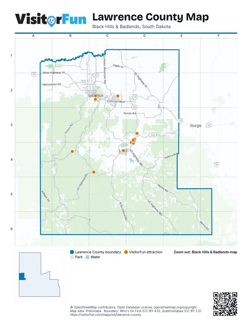
Maps inside Lawrence County
1 map inside, from the street map of Lawrence County down.
Street index of Lawrence County
Each street on the sheet and the grid squares it crosses.
- Purple Heart Memorial HighwayC2
- US Highway 14AC2, B3, C3, D3, E3, B4, C4, D4
- US Highway 85C1, C2, D2, D3, B4, C4, D4, A5, B5, A6
- US Highway 385D4, D5, D6, E6
- SD Highway 34C1, D1, D2
- East Colorado BoulevardC2, D2
- North AvenueC2
- Main StreetD3, D4
- North 27th StreetC2
- North Main StreetC2
- West Jackson BoulevardC2
- East Main StreetC4, D4
- East Jackson BoulevardC2
- Pioneer WayD3, D4
- Cliff StreetD4
- Glendale DriveC4
- Sherman StreetD2, D3, D4
- Spearfish Canyon RoadC2
- 1st AvenueC2
- South Main StreetC4
- Pine StreetD2, D3
- Charles StreetC2, D4
- West Main StreetC4
- Fairview AvenueC4
- Baltimore StreetC4
- Boulder Canyon RoadE3
- Nemo RoadD5, E5, E6, F6
- West Highway 14A1, B1, A2, B2, C2
- Saint Onge RoadD1, D2
- Old Belle RoadB1, C1, B2
- Hillsview RoadB2, C2
- Red Hill RoadB1, A2, B2
- Nevada Gulch RoadC4
- McGuigan RoadB2
- Saint Joe StreetC2
- West Oliver StreetB2, C2
- Evans LaneC2
- Windmill DriveC2
- North 10th StreetC2
- University StreetC2
- West Mason StreetC2
- Sandstone Hills DriveC2
- Jonas BoulevardC2
- East Rushmore StreetC2
- East Colorado Boulevard / Saint Onge RoadD2
- Tinton RoadB2, B3, B4, B5
- South Rapid Creek RoadA5, A6, B6, C6
- North Rochford RoadC4, C5, C6, D6
- Maitland RoadC2, C3, C4
- Whitewood Valley RoadE1, D2, E2
- Galena RoadD4, E4
- Lookout Mountain RoadC1, C2
- Boles Canyon RoadB5, B6
- Homestake RoadA2, B2
- Crook City RoadD3
- Chicken Creek RoadB1
- Roughlock Falls RoadB4
- Mount Roosevelt RoadC3, D3
- 196th StreetC1, D1
- Vanocker Canyon RoadE5
- Acorn Ridge RoadD2
- Wagon Canyon RoadA4, B4
- Whitewood Service RoadD2, D3, E3
- Rochford RoadD6, E6
- Kirk RoadC4, D4
- Christensen DriveC2, C3
- Brookview RoadC2
- McNenny RoadB1
- Centennial RoadC2, D2
- Lower Redwater RoadB1
- Airport RoadC2
- North Rainbow RoadC2
- Upper Redwater RoadB1
- Kerwin LaneC2
- Industrial DriveC2
- Eden RoadE3
- Camp Comfort RoadB2, C2
- North Canyon StreetC2
- Johnson LaneC1
- North 3rd StreetC2
- Tumble Weed TrailB2
- West Summit StreetC4
- West Pine StreetC2
- Upper Valley RoadC2
- South Rainbow RoadC2
- Duke ParkwayD2
- Laurel StreetD2, D3
- Aspen DriveC2, C4
- Roughlock LaneC2
- South Canyon StreetC2
- North State StreetC2
- Mineral PlaceB2
- East Grant StreetC2
- Heritage DriveC2
- Meade StreetD2, D3
- Saddlehorn DriveC2
- East Summit StreetC4, D4
- West King StreetC2
- Russell StreetB2, C2
- College LaneC2
- Ryan RoadC2, D4
- Woodland DriveC2
- Bluestem BoulevardC2
- Central Main StreetC4
- North StreetD2, D4
- Mill StreetC4
- Golden Gate StreetC4
- Dahl RoadC2
- Hooker StreetD2
- 5th AvenueC2
- Dorsette RoadB1
- 10th AvenueC2
- West Grant StreetC2
- East Michigan StreetC2
- East Dakota StreetC2
- North 12th StreetC2
- Stampede DriveC2
- South 35th StreetC2
- Winterville DriveC2
- South 27th StreetC2
- West Nash StreetC2
- West Michigan StreetC2
- Elkhorn Peak LaneC2
- Garfield StreetD2
- CC Curran AvenueC4
- Falcon Crest DriveC2
- South 26th StreetC2
- Recreation LaneC2
- Old Whitewood RoadE3
- East Ohio StreetC2
- Old Highway 14A2
- Brookview Road / Kerwin LaneC2
- Wood RoadB1
- Higgins Gulch RoadB2, B3
- Long Draw RoadB5, C5, B6
- Bear Ridge RoadA2, A3
- Besant Park RoadC5, C6
- Brownsville RoadC4, C5, D5
- Timber Gulch RoadB4, B5
- Custer Crossing RoadD5, C6, D6
- Weisman RoadD2, E2
- Hanna RoadC4, C5
- Lucky Strike RoadD5, E5
- Yellow Creek RoadC4, D4, C5
- Elk Creek RoadD4, E4, D5
- Merritt Estes RoadE6
- Beaver Creek RoadA3, B3, A4
- Riflepit RoadA5
- Old Ridge RoadE4, E5
- FSR 220.1C2, C3
- Crooked Oaks RoadD1
- County Road 631B6
- Box Elder Ridge RoadD6
- Dalton Lake RoadE5, F5
- County Road 233 2DB6, C6
- Paha Sapa RoadD5
- Misty Meadows RoadE5, E6
- Schoolhouse Gulch RoadA4, B4
- Englewood RoadC4, C5
- Cutting Mine RoadC4
- Custer Peak RoadD5
- Terry Summit RoadC4
- Two Bit RoadD3, D4
- Roubaix Lake RoadD5, D6
- Crow Creek RoadB2
- Forestry Road 198E5, D6, E6
- Creekside LoopB1, C1
- Erickson RoadE4
- Jackson RoadD2, E2
- Limestone RoadB4, B5
- Burno Gulch RoadC3
- Minnesota RidgeD6
- Forestry Road 144E5, F5, F6
- Nahant RoadC6
- Crackerjack RoadE2
- County Road 189B6
- Anderson RoadD2
- Fogelsong RoadC1, D1
- Willow Springs RoadA5
- Wharf Mine RoadC4
- Whispering Winds LaneD6
- Camp 5 RoadE3
- Boundary Gulch RoadA3, A4
- Pendo RoadC3, D3
- Crook Mountain RoadD3, E3
- Ridley RoadC2, D2
- Boxelder Forks RoadE6
- Richmond Hill RoadC3, C4
- North Sale Barn RoadD1
- Rockland RoadD5
- Forest Service Road 229C5, D5
- Corral Creek RoadD5
- Frontier LoopE2
- Dane Church RoadD2
- Gilt Edge RoadD4
- FSR 628.1C3
- Benchmark RoadE5
- Roman RoadC3
- 123rd AvenueE1
- Ridgefield LoopD2
- Larson RoadD4, D5
- Crow Peak Bench RoadB2
- Sheep Tail Gulch RoadC3, C4
- Timberline RoadB2
- Ida Grey DriveC3
- Tetro Rock RoadC3
- Gold Dust TrailD5
- Harvey RoadD4
- Fantail Creek RoadC4
- Rinker LaneB5, B6
- Pine Cone AvenueC2
- Rocky Johnson RoadD5, D6
- Valley Ranch RoadB1, C1
- Bridger Canyon TrailC2, D2
- Timber Ridge LaneD3
- Lazy Horse LaneC2, C3
- Patriot LaneD5, E5
- Pasque LoopB3, C3
- Mossing LaneB1, B2
- Lost Gulch RoadD4
- Aster RoadB3
- Hardin LaneC1
- Aspen Hills RoadB3
- Forest Road 203.1CD6
- Spring Canyon RoadE3
- Minnesota Ridge RoadD6
- Kelley Spur RoadE5
- 194th StreetC1, E1
- Forest Service Road 688D5
- Juso Ranch RoadC5
- Erskine Gulch RoadF6
- Lookout Vista RoadC2
- Westview DriveB2
- Oak Ridge RoadC2
- Wormdahl RoadE3
- Lost Camp TrailC4
- Gobbler RoadB2
- Holso RoadD5
- Moskee RoadA5, A6
- False Bottom Creek RoadC3
- Forest Service Road 248D4
- Oak DriveD2
- High Pines RoadD5, E5
- Keough LaneE5
- Laird RoadB6
- Bighorn RoadE2
- Snowcat RoadC4
- Last Chance TrailC4
- Merritt RoadE3
- Cedar Berry AvenueB2
- Washington LoopE3
- Deer Mountain RoadC4
- McInerny RoadB5
- Apple Springs BoulevardE3
- North 5th StreetC2
- County Road 393B5
- Koskela Ranch LaneD5
- Strawberry Hill LaneD4
- Mountain View DriveC4
- Sale Barn RoadD1
- Rawhide RoadE2
- Pyrite DriveC3
- Forest Road 203.1ED6
- Whitetail DriveC4
- Weyrich LaneD2
- Carbonate RoadC3
- Polo LoopD3
- Washington StreetC2, D3, C4, D4
- Rusty J LaneD6
- North Tinton RoadB2, C2
- Forest Service Road 247D4
- Railroad AvenueD3, C4
- Oyster Mountain LaneE3
- Old US Highway 14D2
- Fager RoadE2
- Big Lead Hill RoadD4
- Williams StreetD3
- Spring Run RoadD4
- Tomahawk LaneD4
- Fish Hatchery LoopC2
- Tres Crosses LaneD2
- Wildberger RoadE3
- Fallen Pine RoadE3
- Mountain Stream RoadC4, C5
- Iron Creek Lake RoadB3, B4
- Forest Road 204.1AD6
- Eagle Ridge RoadC3
- Red Hill PlaceA2, B2
- Rochford Ridge RoadC5
- 117th AvenueD1, D2
- Louis RoadE3
- Upper Mirror Lake RoadA1, B1
- 195th StreetE1
- Boxelder Conservation RoadE5
- Kellam LaneC1
- Forestry Road 201E6
- Robbers Roost RoadC2
- Twin Peaks LaneF6
- Ridge RoadB2, C4
- Meadow LaneB2
Things to do on the Lawrence County map
Places on the map
- Boulder Canyon
- Central City
- Cheyenne Crossing
- City of Spearfish Landfill
- Clyde Ice Field
- Coxes-Mirror Lakes Game Production Area
- Crook City
- Deadwood
- Dodds Subdivision
- Downtown Spearfish
- Dumont
- Elkhorn Ridge Campground
- Elkhorn Ridge Golf Club
- Elmore
- Englewood
- False Bottom Addition
- Green Acres
- Green Acres Addition
- Grizzly Gulch Reservoir
- Harrison-Badger-Trucano Game Production Area
- Heritage Plaza
- Hidden Valley Campground
- Higgins Creek Addition
- Lead
- Lead Country Club
- Lookout Mountain Park
- Maitland
- McGuigan Nature Area
- Mountain Plains
- Mountain Shadows
- Nemo
- North Spearfish
- Open Cut
- Pope and Talbot Addition
- Powder House Pass
- Robaix Lake Campground
- Sandstone
- Spearfish
- Spearfish Canyon Country Club
- Spearfish Canyon Nature Area
Next to Lawrence County
- Sturgis
© OpenStreetMap contributors, Open Database License, openstreetmap.org/copyright · Map data: Protomaps · Boundary: Who's On First (CC-BY 4.0); Quattroshapes (CC BY 2.0)















