

Tennessee map
Alcoa map
About 13,588 people live here (Census Bureau, 2024 estimate). The sheet's index lists 300 streets; Alcoa Highway, Pellissippi Parkway and Louisville Road cross the most grid squares. Also on it: Green Meadow Country Club, Hunt Field and Hunters Crossing.
Open the map (PDF, US Letter)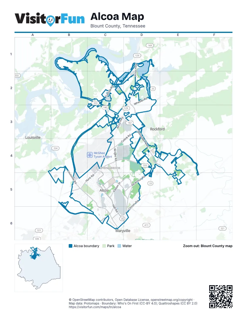
Street index of Alcoa
Each street on the sheet and the grid squares it crosses.
- Alcoa HighwayD1, D2, C3, D3, C4, C5
- Pellissippi ParkwayB2, C2, C3, D3, D4
- North Hall RoadC5, C6
- South Hall RoadC6, D6
- Louisville RoadB4, B5, C5, C6
- Topside RoadC2, D2
- East Hunt RoadC4, D4
- Middlesettlements RoadB5, B6, C6
- Tesla BoulevardC4, C5
- West Hunt RoadC4, B5, C5
- West Bessemer StreetC6
- Marconi BoulevardC5
- Old Knoxville HighwayD4, E4
- East Bessemer StreetC5, C6
- Airbase RoadC3, B4
- East Broadway AvenueD4, D5
- South Calderwood StreetC6
- Tyson BoulevardC4
- North Calderwood StreetC6
- Atchley DriveB6
- North Wright RoadC4, C5, D5, D6
- Cusick RoadD3, C4, D4
- Springbrook RoadC4, C5, D5
- McArthur RoadD4, D5
- South Singleton Station RoadD2, D3
- Clayton RoadD4, E4
- Lincoln RoadD5, C6, D6
- Alcoa TrailD4
- East Edison StreetC5
- Faraday StreetC5
- Proffitt Springs RoadB4, B5
- Williams Mill RoadD4, E4
- McCammon AvenueC6
- Joule StreetC6
- Vose RoadC5
- Wildwood RoadF5
- North Everett High RoadD6
- Sam Houston School RoadE4, F4, F5
- Wrights Ferry RoadC2, C3
- Aluminum AvenueC5, C6, D6
- Stonybrook RoadC3
- Regal DriveC3, D3
- Wheeler RoadD2, D3
- Singleton Station RoadC2, D2
- Alcoa North PlantC4, D4
- Poplar StreetD4, C5, D5
- Grade RoadD3, D4
- Russell RoadD4
- Vista RoadD2, C3, D3
- Dalton StreetC4, C5
- Garfield StreetD5
- Lodge StreetC5
- Stewart LaneC3
- Mills StreetC4, C5
- Peppertree DriveC5
- Alcoa RoadC4, C5
- Ramsay StreetC4, C5
- Hunters Crossing DriveC6
- Southwick DriveB5
- Northpark BoulevardC3, D3
- Mimosa Heights DriveD3
- Brighton DriveB5
- Aberdeen DriveC5
- Flagship Knoxville DriveC4, C5
- Alcoa South PlantC5, C6
- Beverly DriveB5, C5
- Albert Davis DriveC5
- Nobel StreetC4, C5
- Maury StreetC4, C5
- Andover BoulevardB5
- Darwin StreetC4, C5
- Hamilton Crossing DriveC6
- Linford CircleB5
- Cherry StreetC4, D4
- Banebury LaneB5, C5
- Grant StreetD5
- St Ives BoulevardB5, C5
- East Old Topside RoadC2, C3
- Orstead StreetC4, D4, D5
- Kelvin RoadC5
- Alcoa WayD1, D2
- Avenue BC6
- Associates BoulevardC5
- Harding StreetD5
- Snodderly StreetB5
- Mildred DriveB5, C5
- North Rankin RoadC6
- Vera DriveB5, C5
- Gilbert StreetC4, C5
- Gill StreetC6, D6
- Island Home RoadD2
- Chandler RoadC3
- Lindsay StreetC6
- Telford StreetC6
- Rocky Waters DriveC3
- Dogwood StreetB5
- South Rankin RoadC6
- West Lincoln RoadC6
- East Bell StreetC5
- Curie StreetC5
- Grayson DriveD5
- Kirkwell DriveC5
- Davies StreetC5, C6
- Claiborne StreetC2
- Duncan Station RoadD4
- Wright RoadC4, D6
- Kettering RoadC4
- Goddard StreetB5
- Ambrose StreetC4, B5, C5
- Edenbridge DriveC5
- Fountain View CircleC5
- West Cunningham StreetB5
- Northbend CircleD3
- East Howe StreetC5
- Hoopes StreetC4
- North Linden DriveC5, C6
- Hannum StreetC6
- West Fulton StreetC5
- Tusga DriveC5
- Mildred CircleB5
- West Howe StreetC5
- Sanderson StreetC6
- Green Meadow Country Club RoadB5, C5
- West Edison StreetC5
- Glascock StreetC6
- McBath RoadC2, C3
- Hillside DriveD2
- West Watt StreetC5
- Maple StreetC5, D5
- Birch StreetD4, C5
- Lois LaneC3
- Riversedge RoadC2, D2
- West DriveC3, D3
- Adkins WayC3
- Murdock StreetC5
- Rose AvenueD5
- Armona RoadB5
- Caldwell LaneD3
- Liberty StreetB5
- East Cunningham StreetC4, B5, C5
- Hamilton StreetC5
- Link DriveC5
- Wedgwood DriveC5
- Airway DriveC3, D3
- West Newcomen StreetC5, C6
- Payne AvenueC4
- Holloway StreetB5
- Cedar StreetC4, C5
- Margaret DriveB5, C5
- Jasmine LaneB5, B6
- South Linden DriveC5, C6
- Cochran StreetD5
- Harvest LaneC6
- Airport Plaza BoulevardC4
- Newton StreetC5, C6
- Pinnacle Point DriveB5
- Remsen StreetC4, C5
- West Whitney CircleC5
- Badgett StreetD6
- West Stephenson StreetC5, C6
- Savannah StreetC2
- Ford StreetC4, C5
- Hollister DriveB5
- Lakeside DriveC2
- Ohm StreetC5
- Tupelo WayD2
- East Watt StreetC5
- Huxley StreetC4, C5
- Franck StreetC5
- Crosswinds WayB5
- Locust StreetC5
- Rockford Boyd RoadD4
- Perkins StreetC5
- Victoria LaneB5
- Lindenhall DriveB5
- Andy Carr AvenueD6
- Benford LaneB5, C5
- St. Thomas WayC5
- Steele StreetD6
- Kings CourtC5
- Burns StreetD6
- Central Park BoulevardC2
- East Newcomen StreetC5
- Morse StreetC5
- Airway Ridge RoadD2
- 8th StreetD5
- Brenda DriveC6
- Lakemont DriveD2
- Ansley DriveB5
- Crescent DriveD3
- East Franklin StreetC5
- Clingman View DriveB5
- Hayes StreetD5
- Airfield DriveC4
- Long RoadC4
- Tarbett RoadD3
- Harrison StreetD5, D6
- Marilyn LaneC5, C6
- Whipporwill StreetB5, C5
- Roosevelt StreetD5
- 3rd StreetD5, D6
- Bessie Harvey Avenue EastD6
- Boyle StreetC4
- Kimsey StreetD3
- Hawks Landing DriveC2
- Marti LaneB5
- Red Hill DriveD2
- Killion StreetD3
- Waterlily LaneB5
- Buick DriveC3
- Norris PlaceC4, D4
- Airline DriveC3
- West Franklin StreetC5
- Burroughs RoadC4
- Arabian LaneC6
- North Star CircleC3
- Boxwood AvenueD5
- Judson DriveC3
- Brewster RoadC4
- Corporate PlaceC5
- East Newton StreetC5
- Pauling StreetC5
- Elm BoulevardD5
- Fletcher StreetD5
- Frary StreetC4
- Juniper AvenueD5
- East Stephenson StreetC5
- Springdale StreetC6
- West Bell StreetC5
- Dresden WayD2
- Rutledge StreetC2
- Hemlock StreetD5
- Riverlake LaneD1
- Limestone DriveC3
- Deforrest StreetC6
- Center StreetD4
- Centennial Park BoulevardC5
- McGinley StreetD6
- Milford AvenueD4
- Cardin LaneD3
- Belfor CircleC4
- Laurel StreetD5
- Westgate DriveC5
- Mount Lebanon RoadE4
- International AvenueC4
- Sandstone DriveC3
- Jeania LaneC6
- Badgett AlleyD6
- Spruce StreetD5
- Parkview PlaceB5
- Maury CircleC4
- Janes RoadB5
- Starlite RoadD2
- Volta StreetC5, C6
- Osley DriveC6
- Chandler Station RoadC2
- Furrow WayC4
- Pearly Smith RoadC2
- Lakeview CourtD2
- Woodcrest DriveD5
- Amanda DriveB6
- Marriott DriveC2
- Covey CourtB5
- Harvey StreetD5
- Oscar Harris DriveD4
- Kerrway LaneD4
- Pasteur PlaceC5
- Lake StreetC5
- Breckwill LaneC5
- Thomas DriveD5
- Lewis StreetC4
- Beech StreetC4, C5
- Jeffrey LaneB5
- Whitney StreetC5
- Holiday DriveE4
- Olympia DriveD6
- Cimarron StreetC6
- Glco StreetC3, C4
- Manor WayD2
- Redwood StreetD5
- Orr CircleC6
- Xcell LaneC2
- Ash StreetD5
- Avenue CC6
- Northcross DriveD3
- Orton DriveD5
- Oakland StreetC5
- Arwood DriveC2
- Meadowview PlaceB5
- Old Sam Houston School RoadE4, F4
- Bennett LaneC2
- Avalon DriveC2
- Evelyn AvenueB6
- Breedlove LaneD4
- Railroad AvenueD6
- Jones RoadC3
- Castle LaneD3
- Lee Delia LaneB5
- Ridge StreetC6
- Leslie LaneC3
Places on the map
- Aaron
- Alcoa Duck Pond
- Alcoa Elementary School
- Alcoa First Methodist Church
- Alcoa Little League Park
- Alcoa Middle School
- Alcoa Post Office
- Alcoa Public Safety Complex
- Alcoa School Complex
- Alcoa United Methodist Church
- ALDI
- Blount County Access Area
- Blount County Highway Department
- City of Alcoa Public Works
- Clayton Homes
- Clayton-Bradley Academy
- Cornerstone of Recovery
- Fort Sanders - Topside
- Green Meadow Country Club
- Greenbelt
- Hall Park
- Hamilton Crossing
- Hunt Field
- Hunters Crossing
- Midland Plaza
- New Midland Plaza
- Pellissippi Place
- Rock Garden Park
- Sherwood Memorial Gardens
- Smith & Wesson
- Springbrook Church
- Springbrook Farms
- Springbrook Park
- The UPS Store
- Topside Corner
- UTREC Blount Unit
- Walmart Supercenter
Next to Alcoa
- Louisville
- Maryville map
- Rockford
© OpenStreetMap contributors, Open Database License, openstreetmap.org/copyright · Map data: Protomaps · Boundary: Who's On First (CC-BY 4.0); Quattroshapes (CC BY 2.0)















