

Tennessee map
East Tennessee map
The sheet's index lists 38 highways; I-75, I-40 and I-24 cross the most grid squares. Things to do inside the boundary: American Museum of Science and Energy, Anakeesta and Andrew Johnson National Historic Site. Also on it: Athens, Chattanooga and Church Hill.
Open the map (PDF, US Letter)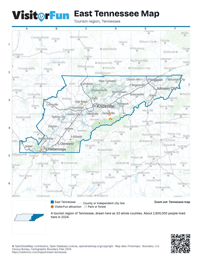
Highway index of East Tennessee
Each highway on the sheet and the grid squares it crosses.
- I-24A4, A5, B5
- I-26E2, E3
- I-40B3, C3, D3, D4
- I-75B4, B5, C2, C3, C4
- I-81D3, E2, E3
- I-140C3
- I-275C3
- I-640C3
- US 11B5, C3
- US 11ED3
- US 19WE3
- US 23E2, E3
- US 25ED3
- US 25WC3
- US 27A5, B4, B5
- US 64A4, A5, B5
- US 70C3
- US 74B5
- US 129C3
- US 321E3
- SR 32D3
- SR 58C3
- TN 60B5
- SR 63C3
- SR 67E3
- TN 71C3
- SR 93E2
- TN 93E2
- SR 111B4
- TN 111B4
- SR 137E2
- TN 153B5
- TN 158C3
- SR 162C3
- TN 162C3
- SR 299B3
- SR 317B5
- SR 319B5
Things to do on the East Tennessee map
- American Museum of Science and Energy
- Anakeesta
- Andrew Johnson National Historic Site
- Bristol Motor Speedway
- Cades Cove
- Chattanooga Ghost Tours
- Children's Museum of Oak Ridge
- Cove Lake State Park
- Craighead Caverns
- Cumberland Mountain State Park
- Dolly Parton's Stampede
- Dollywood
- Escapology Chattanooga
- Gatlinburg SkyBridge & SkyLift Park
- Great Smoky Mountains Heritage Center
- Great Smoky Mountains National Park
- Hamilton Place
- Hiwassee Loop Train Ride
- Hunter Museum of American Art
- Knoxville Museum of Art
- Lookout Mountain Incline Railway
- Muse Knoxville
- Museum Center at Five Points
- Museum of Appalachia
- Newfound Gap
- Ober Mountain
- Raccoon Mountain Caverns
- Ripley's Aquarium of the Smokies
- Ripley's Believe It or Not! Odditorium
- Roaring Fork Motor Nature Trail
- Ruby Falls
- Sunsphere
- Tanger Outlets Sevierville
- Tennessee Aquarium
- Tennessee Valley Railroad Museum
- The Island in Pigeon Forge
- The Old Mill
- The Parkway
- Titanic Museum Attraction
- Zoo Knoxville
Places on the map
- Athens
- Chattanooga
- Church Hill
- Cleveland
- Crossville
- Dayton
- Erwin
- Etowah
- Greeneville
- Halls
- Harriman
- Jasper
- Johnson City
- Kingsport
- Knoxville
- LaFollette
- Lenoir City
- Maryville
- Maynardville
- Morristown
- Mountain City
- New Tazewell
- Newport
- Oak Ridge
- Rogersville
- Sevierville
- Soddy-Daisy
- Spring City
Next to East Tennessee
- North Alabama
- Northwest Georgia
- Eastern Highlands-South
- Southern Kentucky Lakes and Rivers
- Asheville & the Foothills
- High Country
- Smoky Mountains & Cherokee
- Middle Tennessee map
- Southwest Virginia - Blue Ridge Highlands
- Southwest Virginia - Heart of Appalachia
© OpenStreetMap contributors, Open Database License, openstreetmap.org/copyright · Map data: Protomaps · Boundary: U.S. Census Bureau, Cartographic Boundary Files 2024