

Texas map
Brenham map
About 19,728 people live here (Census Bureau, 2024 estimate). The sheet's index lists 300 streets; US Highway 290 West, South Blue Bell Road and South Day Street cross the most grid squares. Things to do inside the boundary: Blue Bell Creameries and Visit Brenham.
Open the map (PDF, US Letter)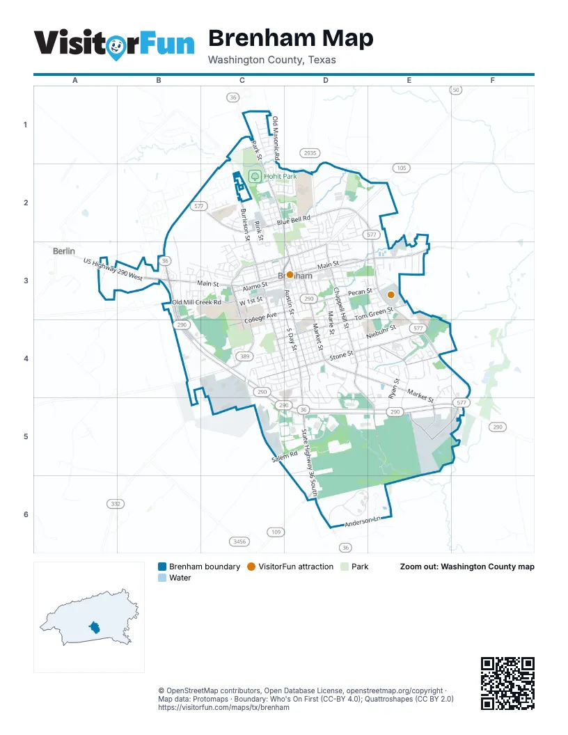
Street index of Brenham
Each street on the sheet and the grid squares it crosses.
- US Highway 290 WestA3, B3, B4, C4, C5, D5
- South Blue Bell RoadE3, E4, E5, F5
- Gun and Rod RoadE4, F4, F5
- State Highway 36 SouthD5, D6
- West Main StreetB3, C3, D3
- South Day StreetC3, D3, D4, D5
- West Blue Bell RoadB2, C2
- East Blue Bell RoadC2, D2
- North Blue Bell RoadD2, E2, E3
- State Highway 36 NorthB3
- South Market StreetD3, D4, E4, E5
- South Chappell Hill StreetD3, D4, E5
- North Park StreetC1, C2, D2, D3
- South Austin StreetD3, D4
- East Alamo StreetD3, E3
- East Main StreetD3
- Prairie Lea StreetC3, C4
- College AvenueC3, D3, C4
- West Alamo StreetC3, D3
- North Austin ParkwayC3, D3
- West Tom Green StreetC4, D4
- North Chappell Hill StreetD3
- Farm-to-Market Road 109D6
- US Highway 290 EastD5, E5, F5
- East Stone StreetD4, E4
- Burleson StreetC1, C2, C3
- East Tom Green StreetD3, E3, D4
- South Jackson StreetC3, C4
- Blinn BoulevardC3, C4
- James Nutt BoulevardE5
- Pecan StreetD3, E3
- Martin Luther King Jr ParkwayC3, D3
- Old Mill Creek RoadB3, C3
- West Stone StreetC4, D4
- Old Chappell Hill RoadE3
- East Academy StreetD3
- Lounge RoadC1
- Handley StreetE5
- US 290 Frontage RoadC4
- West Jefferson StreetB3, C3
- South Park StreetD3, D4
- Church StreetD3, D4
- South Baylor StreetD3, D4
- North Dixie StreetB2, B3
- Niebuhr StreetD4, E4
- West 1st StreetC3, D3
- Key StreetC3, C4, D4
- West Lubbock StreetC4, D4
- Anderson LaneD6, E6
- Appel WayB4, C4
- West Mansfield StreetC4, D4
- Industrial BoulevardC4, C5
- West 5th StreetD3, C4
- Lee StreetD3, D4
- Longwood DriveC4, C5
- West 2nd StreetC3, D3
- Ryan StreetE4, E5
- Cantey StreetE4, E5
- Chauncy StreetC4, D4
- Kerr StreetD3
- Allison StreetD4, E4
- Wood Ridge BoulevardD5
- Legrand StreetC2
- Becker DriveD4, D5
- Haskins BoulevardD6, E6
- Lauraine StreetD2, E2
- Sycamore StreetD3
- Farewell StreetC4
- East Mansfield StreetD4
- Spinn StreetC4, D4
- Clinton StreetD3
- Davy StreetC2
- Old Independence RoadD2
- Tison StreetC4, D4
- High StreetC3, C4
- Marie StreetD3, D4
- Loesch StreetD3, E3
- Oakwood DriveC1
- Texan TrailD6, E6
- South Saeger StreetC3
- Oak Hollow LaneE4
- Old Masonic RoadC1, C2
- West Val Verde StreetC4, D4
- North Market StreetD3
- Atlow DriveC4, D4
- Independence StreetD2
- West Vulcan StreetC3, D3
- Salem RoadC5, D5
- Harrison RoadD4
- Seelhorst StreetD3
- Washington StreetD3, D4
- Airline DriveD4, D5
- Landua DriveE4
- Green StreetC3, C4
- Gay Hill StreetD2, D3
- Twisted Oak DriveC1
- Hillside DriveC3
- Schulte BoulevardC5, D5
- West 3rd StreetC3, D3
- East 6th StreetD3
- Geney StreetC4
- Rink StreetC2, C3
- East Commerce StreetD3
- Ewing StreetC2
- Ross StreetD2, D3
- Crockett StreetD2
- Fannin StreetC2
- Medical ParkwayD4, D5
- Springwood DriveE4, F4, E5
- Beazley StreetC4
- Robinhood RoadC3
- Welcome WayD6
- Cottonwood StreetD2, D3
- East Germania StreetD3
- Ahrens AvenueE4
- West Wilkins StreetC3
- Barbee StreetD2, D3
- Briscoe StreetC2
- Bormann StreetE3
- Garrett StreetD3
- Westwood LaneB3
- Heritage DriveD4
- West Bryan StreetC4, D4
- Stringer StreetD4
- A H Ehrig DriveC2, D2
- Kuhn LaneD5
- Northview Circle DriveC2
- Autumn Rain DriveC2
- Higgins StreetC2
- Duprie DriveC2, D2
- West 6th StreetC4, D4
- Clayton DriveC3
- Peabody StreetC3, D3
- Basin TrailE4
- Charles Lewis StreetC4, D4
- Timber Oaks DriveB3, C3
- Shepard LaneE3
- Progress DriveD4, D5
- L J StreetC3
- Mangrum StreetD3
- Swain StreetD4
- Muse StreetD2
- Victory LaneF4, F5
- Riggs StreetD2
- South Lubbock StreetC4
- Stone Hollow DriveD4, D5
- South Dixie StreetB3
- Cheyenne DriveE4, E5
- Simon StreetD2
- Walnut StreetD4, E4
- Pecan Circle DriveC2
- Greenway DriveE4
- East Lubbock StreetD4
- Sabine StreetD2
- Williams AvenueD2
- Matchett StreetC3
- Walnut Hill DriveD4
- Wyandotte LaneB3, C3
- East Rosedale DriveE4, F4
- Alois LaneE2, E3
- Zoo LaneE6
- Laney StreetC2, D2
- Rippetoe StreetC3
- Scenic DriveC1
- Woodson LaneD3, D4
- Brookbend DriveC1
- North Baylor StreetD3
- Mulberry StreetC3
- Carrington LaneE3
- Ava DriveC2, D2
- Hosea StreetD2, D3
- Century CircleD4
- Stone Hill DriveD4
- Carlee StreetD4
- Mc Neese StreetC2
- Valley DriveD4, D5
- Republic StreetC2
- Clear Spring DriveC3
- Hickory Hollow LaneC1
- Johnson StreetD2, D3
- Marjorie StreetD4
- Rhames AvenueD4
- Lawndale AvenueD4
- Peachtree DriveD4
- Sayles StreetC2
- Harrington StreetD2
- Dillon StreetE4
- Mustang RoadE4
- Pleasant View AvenueC3
- Jitney JunctionE6
- Hollis DriveE4
- Glenda BoulevardE4
- Stephanie StreetD2
- Service WayE6
- Westpoint LaneA3
- Clay StreetD2
- Milroy DriveD4
- Gun and Rod CircleE4
- Shady LaneD4
- Longhofer StreetE3
- Rucker StreetC2
- Armbrister StreetD2
- Cobble Gate DriveC2
- Liberty StreetD3
- Navarro DriveC2
- Tracye Lee DriveC4
- Brookside DriveC1
- North Drumm StreetB3
- North Austin StreetC3
- Munz StreetB3
- Baber StreetC3
- Top Hill DriveC3
- Corey StreetE4
- Nolan StreetE5
- Campbell StreetD2
- South Drumm StreetB3
- Parker CourtE4
- Lauraine LaneE2
- Rosenbaum DriveE4
- Kirk DriveC4
- Meadow LaneB3, C3
- Rivers StreetC2, C3
- Barnhill StreetD3
- Old North Market StreetD2, D3
- Spencer StreetD3
- Weldon Trace StreetD2
- Medical CourtsD4, D5
- Brown StreetD2
- Sandra DriveD4
- North Saeger StreetC3
- San Jacinto DriveC2
- Goessler StreetD4
- Hudson StreetC3
- Lynne Way StreetD4, D5
- Jersey LaneD4
- Lott LaneE3
- Mount Olive StreetD2
- Durden StreetD3
- Burch StreetD3
- Bridge StreetD3
- Matilda StreetD2
- Edward LaneB3
- Leghorn DriveB3
- Lakeview DriveC4
- Lacy LaneE3
- Eldon StreetB3
- Cornish DriveB3
- Dark StreetD3
- Shepard StreetC3
- West Germania StreetD3
- Alma StreetD2, D3
- Cena DriveD4
- Morgan StreetC4
- Robinson DriveC2
- Huisache StreetD4
- Leslie D LaneE3
- Maize CourtE4
- Mill Creek RoadC3
- Rosewood StreetD4
- Thiel StreetD3
- Timberline CourtE4
- Aarable CourtE4
- Pickle CircleC4, C5
- Schomburg StreetD2
- West Commerce StreetD3
- Brooks LaneE3
- Schumacher StreetC3
- Hampshire DriveB3
- Carriage LaneD4
- Brenham Junior High School Student Pick-up & Drop-offD4
- Reimer StreetE3
- Lockett StreetC3
- Carondelet CourtF4
- Faulkner StreetC4
- Glenn DriveC2, C3
- Limit StreetE3
- Petty StreetD3
- Rodney StreetD4
- Sweed StreetE3
- East Sayles StreetC2, D2
- Grimes DriveC2
- Jeffries StreetC2
- Nelson StreetD3
- Yager DriveD3, E3
- Magnolia DriveC1
- Giddings LaneD4
- Wintersong DriveC2
- South Saint Charles StreetD3
- Eleanor StreetD2
- Joseph StreetC3
- Cedar StreetC2
- Scott DriveD4
- Gavin DriveC2, D2
- Brenham Middle School Student Pick-up & Drop-offE3, E4
- Westwind DriveC4
- Mark T DriveC4
- Center StreetD2, D3
- Ledbetter LaneD3
- Norris StreetD3
- East Vulcan StreetD3
Things to do on the Brenham map
Places on the map
- Academy Sports + Outdoors
- Ace Hardware Brenham
- Alton Elementary School
- Alumni Field
- Americas Best Value Inn Brenham
- Ant Street Inn
- Appel Ford
- Argent Court Assisted Living
- Auto Salon
- B'Nai Abraham Cemetery
- Bank of Brenham
- Baylor Scott & White Brenham Clinic
- Blinn College
- Bluebonnet Shopping Center
- Brenham Collection/Transfer Center
- Brenham Crossing
- Brenham Downtown Historic District
- Brenham Elementary School
- Brenham High School
- Brenham Junior High School
- Brenham Middle School
- Brenham State Supported Living Center
- Fireman's Park
- Hasskarl Tennis Courts
- Hattie Powers Park
- Henderson Park
- Hohlt Park
- Hohlt Park Walking/Jogging Trail
- Jackson Street Park
- Krause Elementary School
- Kruse Village
- LaRoche Chevrolet Buick GMC
- Linda Anderson Park
- Market Square
- Pickard High School
- Prairie Lea Cemetery
- The UPS Store
- US Post Office and Federal Building
- Washington County Courthouse
- Washington County Fairgrounds
Next to Brenham
- Berlin
© OpenStreetMap contributors, Open Database License, openstreetmap.org/copyright · Map data: Protomaps · Boundary: Who's On First (CC-BY 4.0); Quattroshapes (CC BY 2.0)















