

Texas map
Prairies and Lakes map
The sheet's index lists 44 highways; I-35, I-10 and I-20 cross the most grid squares. Things to do inside the boundary: African American Museum of Dallas, Amon Carter Museum of American Art and Arlington Museum of Art. Also on it: Arlington, Athens and Bastrop.
Open the map (PDF, US Letter)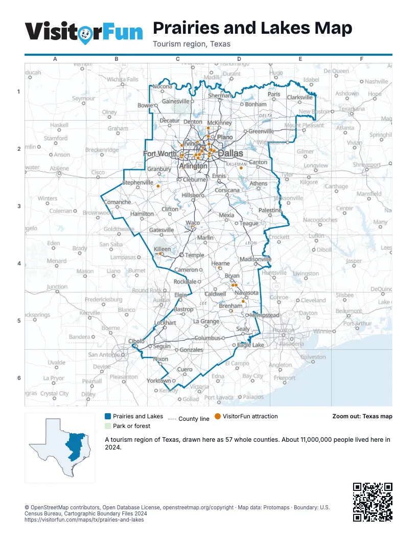
Highway index of Prairies and Lakes
Each highway on the sheet and the grid squares it crosses.
- I-10B5, B6, C5, D5
- I-14C4
- I-20B2, C2, D2, E2
- I-30C2, D2, E2
- I-35B5, C1, C2, C3, C4
- I-35EC2, C3, D2
- I-35WC2, C3
- I-45D2, D3, D4
- I-635C2, D2
- I-820C2
- US 67C2, C3, D2, E2
- US 69D1
- US 75D1, D2
- US 77C2, C3
- US 80D2
- US 81C1, C2
- US 82D1
- US 84C3
- US 90B5, B6, D5
- US 175D2
- US 190C4, D4
- US 287C1, C2, D2, D3
- US 290D5
- US 377C2
- US 380C2
- TX 6C3, D4, D5
- TX 9C4
- TX 21C5
- TX 26C2
- TX 31C3, D3
- TX 36C4, D5
- TX 71C5, D5
- TX 108B2
- TX 114C2
- TX 121C2, D2
- TX 130B5, B6, C5
- FM 157C2
- TX 161C2
- TX 170C2
- TX 183C2
- TX 199C2
- TX 249D5
- TX 360C2
- FM 2499C2
Things to do on the Prairies and Lakes map
- African American Museum of Dallas
- Amon Carter Museum of American Art
- Arlington Museum of Art
- AT&T Stadium Tour
- Bass Performance Hall
- Blue Bell Creameries
- Bolder Adventure Park
- Brazos Bluffs Ranch
- Brazos Tours
- Buescher State Park
- Bureau of Engraving and Printing Fort Worth
- Burleson Museum and Visitors Center
- Cameron Park Zoo
- Camp Hearne
- Chandor Gardens
- Corsicana Visitors Center
- Courthouse-on-the-Square Museum
- Dallas Museum of Art
- Dallas Zoo
- DFW Car and Toy Museum
- Dinosaur Valley State Park
- Dinosaur World
- Epic Waters Indoor Waterpark
- First Monday Canton
- Fort Worth Aviation Museum
- Fort Worth Botanic Garden
- Fort Worth Cultural District
- Fort Worth Nature Center and Refuge
- Fort Worth Stockyards National Historic District
- Fort Worth Water Gardens
- Fort Worth Zoo
- Galleria Dallas
- George Bush Presidential Library and Museum
- George W. Bush Presidential Center
- Golden Triangle Mall
- Grand Prairie Tourist Information Center
- Grapevine Mills
- Hawaiian Falls Waterpark Mansfield
- Highland Park Village
- Homestead Craft Village
- Hopkins County Museum and Heritage Park
- Hulen Mall
- Irving Archives & Museum
- Irving Mall
- John Fitzgerald Kennedy Memorial
- Kimbell Art Museum
- Lake Tawakoni State Park
- Lamar County Historical Museum
- Legoland Discovery Center Dallas Fort Worth
- Magnolia Market at the Silos
- Mayborn Museum Complex
- McKinney Visitor Center
- Modern Art Museum of Fort Worth
- Museum of the American GI
- Mustangs of Las Colinas
- Nasher Sculpture Center
- National Medal of Honor Museum
- National Mounted Warrior Museum
- National Multicultural Western Heritage Museum
- National Videogame Museum
- NorthPark Center
- Palmetto State Park
- Perot Museum of Nature and Science
- Pinstack
- Post Oak Mall
- Red Men Museum and Library
- Reunion Tower
- Ripleys Believe It or Not Grand Prairie
- Ruth Paine House Museum
- Sea Life Grapevine
- Six Flags Over Texas
- Somervell County Historical Society Museum
- Southfork Ranch
- Stanzel Model Aircraft Museum
- Stonebriar Centre
- Stonewall Saloon Museum
- Texas Ranger Hall of Fame and Museum
- Texas Zoofari Park
- The Sixth Floor Museum at Dealey Plaza
- Town East Mall
- Universal Kids Resort
- Waco Mammoth National Monument
- Washington on the Brazos State Historic Site
- Winedale Historical Center
Places on the map
- Arlington
- Athens
- Bastrop
- Bonham
- Bowie
- Brenham
- Bryan
- Caldwell
- Cameron
- Canton
- Cibolo
- Clarksville
- Cleburne
- Clifton
- Columbus
- Comanche
- Corsicana
- Cuero
- Dallas
- Decatur
- Denton
- Eagle Lake
- Elgin
- Ennis
- Fort Worth
- Gainesville
- Gatesville
- Gonzales
- Granbury
- Greenville
- Hamilton
- Hearne
- Hempstead
- Hillsboro
- Irving
- Killeen
- La Grange
- Lockhart
- Madisonville
- Marlin
- McKinney
- Mexia
- Navasota
- Nixon
- Nocona
- Palestine
- Paris
- Plano
- Rockdale
- Sealy
- Seguin
- Sherman
- Stephenville
- Teague
- Temple
- Waco
- Yorktown
Next to Prairies and Lakes
- Chickasaw Country
- Choctaw Country
- Great Plains Country
- Gulf Coast map
- Hill Country map
- Panhandle Plains map
- Piney Woods map
- South Texas Plains map
© OpenStreetMap contributors, Open Database License, openstreetmap.org/copyright · Map data: Protomaps · Boundary: U.S. Census Bureau, Cartographic Boundary Files 2024