

Texas map
Colleyville map
About 26,012 people live here (Census Bureau, 2024 estimate). The sheet's index lists 300 streets; Colleyville Boulevard, Glade Road and Cheek-Sparger Road cross the most grid squares. Also on it: Bluebonnet Hills Memorial Park, Colleyville Nature Center and Melrose Park.
Open the map (PDF, US Letter)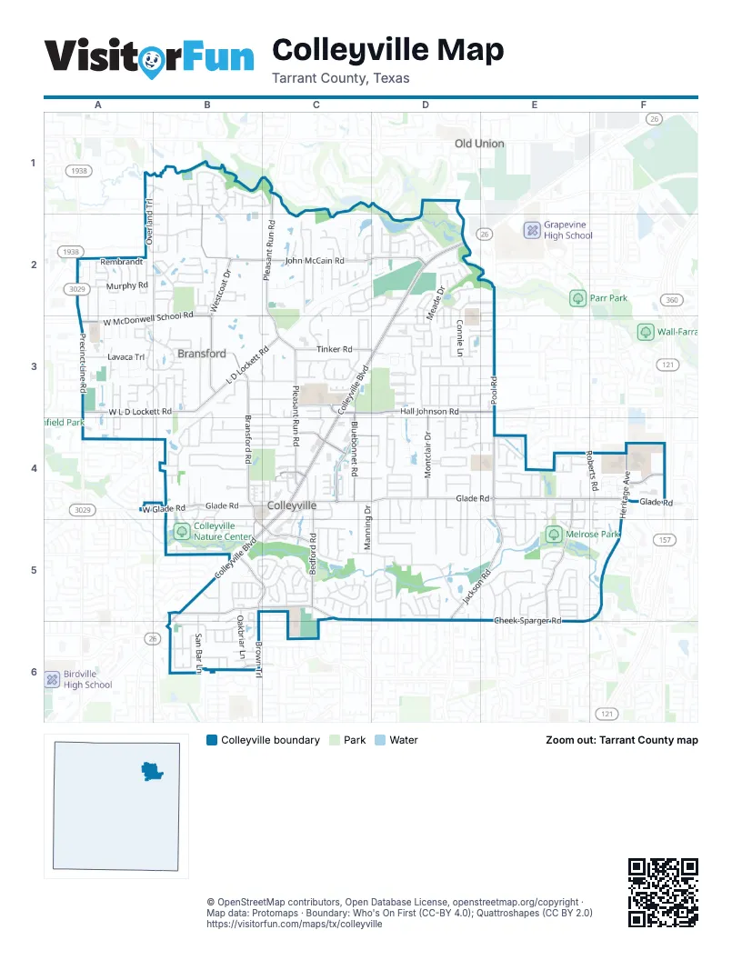
Street index of Colleyville
Each street on the sheet and the grid squares it crosses.
- Colleyville BoulevardD2, C3, D3, C4, B5, C5
- Precinct Line RoadA3, A4
- Ira E Woods AvenueD2
- Glade RoadB4, C4, D4, E4, F4
- Cheek-Sparger RoadB5, C5, D5, E6
- Pleasant Run RoadC1, C2, C3, C4
- Hall Johnson RoadC3, D3, E3
- John McCain RoadB1, B2, C2, D2
- Pool RoadE2, E3, E4
- West McDonwell School RoadB2, A3, B3
- Westcoat DriveB2, B3
- Jackson RoadE4, D5, E5
- West L D Lockett RoadA3, B3
- L D Lockett RoadB3, C3
- Tinker RoadC3, D3
- William D Tate AvenueF4
- West Glade RoadA4, B4
- Mid Cities BoulevardB5
- Heritage AvenueF4, F5
- Bransford RoadB3, B4, B5
- Bluebonnet RoadC3, C4
- Brown TrailB5, C5, B6
- Martin ParkwayE4, E5, E6
- Bedford RoadC4, C5
- Church StreetC4
- Montclair DriveD3, D4
- Gateway DriveF4
- Riverwalk DriveC4
- Centerpark DriveB5, C5
- Main StreetC4
- Bogart DriveC3
- Quail Crest DriveB6
- Murphy DriveE6
- Kingswood LaneC4, D4
- Martin DriveE6
- Simpson TerraceB6
- Oak Knoll DriveC5, D5
- Cemetery RoadC3, D3
- Monticello ParkwayB1, B2
- Lakeside DriveE4, D5, E5
- Tennison ParkwayC2, D2
- Normandy DriveD3, D4
- Murphy RoadA2
- Lafite LaneF4, F5
- Meade DriveD2, D3
- Hardage LaneC3
- Shalimar CourtC2
- Highland Meadows DriveD3, E3
- Ponderosa StreetC3
- Meandering WayD4, E4, D5, E5
- Saddlebrook DriveC5
- Sherwood LaneD5, E5
- Twelve Oaks LaneD2, E2
- Bettinger DriveB3
- Timberline Drive NorthB4
- Lavaca TrailA3
- Overland TrailA1, B1, A2
- Oak Alley DriveC2
- Jefferson CircleB1
- Highland DriveD3
- Remington ParkwayA3, B3
- Miramar LaneD4
- Emerald DriveC2, C3
- Legacy TrailA3
- Providence RoadB2
- Coventry CourtD3, D4
- Highland Hills LaneD3
- Timberline Drive SouthB4
- San Bar LaneB5, B6
- East Jim Mitchell TrailD4, D5
- Oakbriar LaneB5, B6
- West Jim Mitchell TrailD4, D5
- Roberts RoadF4
- Ballantrae DriveD3, E3
- Rustic TrailB4
- Bandit TrailA2, B2
- Plantation Drive NorthC5
- Connie LaneD2, D3
- Bill Simmons RoadD4, D5
- Chestnut BendB3
- Plantation Drive SouthC5
- Pembrooke Parkway WestE5, E6
- Mill Wood DriveB5
- Shelton DriveB3, C3
- Thames TrailD2
- Shadywood LaneE4, E5
- Windswept TrailB1, B2
- Mustang TrailA3, B3
- Stafford DriveC4, C5
- Trianon CourtC2
- David LaneC2
- Manning DriveC4, C5
- Steeplechase DriveB5
- Westmont DriveB2
- Allendale StreetE5, E6
- Lakewood DriveC4, C5
- Greenbriar LaneB6
- RembrandtA2
- Heritage Oaks DriveF4
- Caldwell Creek DriveC2
- Scarborough Lane WestE5
- Saint Moritz ParkwayA2, A3
- Colleyville TerraceB4, C4
- Beverly DriveB3, C3
- Woodstock DriveD5
- Creekview LaneC5
- Melanie DriveD2
- Hickory Hill StreetE5
- Pebble Hill DriveC2, D2
- Green Oaks DriveE4, E5
- Majestic ManorD2
- Eaton CircleE5
- Douglas AvenueC2, D2
- Behrens RoadD4, D5
- Cheshire DriveD5
- Inwood LaneC5
- Coventry PlaceD4
- Hunter TrailA3, B3
- Overlook DriveB1, C1
- Whittier LaneB2
- Arbor TrailD4, E4
- Shadycreek LaneE4, E5
- Buckingham PlaceD5, E5
- Jo Will StreetC2
- Latour LaneF4, F5
- Cedar CourtC2
- Tarrant LaneD3
- Village LaneC4
- Atlanta DriveD2, D3
- Peters PathC2
- Mill Valley DriveB5
- Holly LaneC2
- Lansford LaneD3
- Garry Lynne DriveC4, C5
- Cherry LaneC4, D4
- Fegans PathC2
- Spring HollowE5, E6
- Carriage DriveD2, D3
- Edgewood LaneE4
- Felps DriveB5
- Montreux AvenueA2, A3
- Quails Path RoadB3
- Renfro DriveD5
- Crescent LaneA3
- Preston WayB3
- Oak Crest Hill DriveB4
- Black DriveB5
- Braemar TerraceD2
- Leta LaneB3, C3
- Mill Crossing WestB4, B5
- Oak Valley DriveB4
- Crest DriveC5
- Whitehaven Street NorthD3, E3
- Patterson LaneD4, D5
- Quail Run StreetB6
- Amador TrailD3, D4
- Meadowhill DriveD3
- West Cimmaron TrailA3
- Curtis RoadA2, A3
- Petrus BoulevardE5
- Herbert StreetA2, A3
- Behrens CourtD4, D5
- Broadoak WayD2
- Wayne DriveC5, C6
- Bridlewood SouthB5
- Forest Meadow DriveB1, C1
- Somerset BoulevardC5
- Sterling DriveA3
- Brouthton DriveD3
- Glendale DriveE5, E6
- Fox Glen DriveE4, F4
- Hidden Oaks DriveC3, C4
- Mill Creek DriveB4, B5
- Quality Hill StreetB3
- Tyler StreetD5
- Kennedy DriveD2, D3
- Tillman Hill RoadB1, B2
- Lombardy CourtE5, F5
- Preservation AvenueC4
- Lorraine ParkA3
- Stonebridge DriveC4
- White DriveB3
- Elm StreetB4
- Oak Pointe DriveD3
- Stonehaven DriveD5
- Bordeaux ParkA3
- Alexandra DriveC5
- Mill View DriveB4, B5
- RiverpathA2, B2
- Longwood DriveD2
- Texas TrailA3, A4
- Waldon CourtC2
- Meadowview DriveE4
- Cliffwood DriveB6
- Leesburg DriveB1
- Oak Top DriveB3, B4
- Bridlewood NorthB5
- Maplewood TrailB4, C4
- Armstrong CourtC2, C3
- Hollowbrook CourtE4
- Old Grove RoadB2
- Reagan RoadB3, B4
- Eudaly DriveB4, C4
- Grosvenor LaneD3
- Hillside DriveB4, C4
- Mockingbird LaneC5
- Treemont CircleB5, B6
- Lowrie RoadA3, A4
- Montford DriveD3
- Field StreetB4, C4
- Kingston DriveC3
- Woodland Heights CircleE5
- Independence RoadD3, E3
- Hawthorne AvenueD4
- Kays CourtA3
- Camden GreenD3
- Cottonwood LaneE4
- Bellefonte LaneC2
- Dartmoore LaneC5
- Beldon TrailD4, D5
- Spring Garden DriveD5
- Byron Nelson ParkwayD1, D2
- Carlisle AvenueD4
- Prestwick DriveF4, F5
- Ponderosa LaneC3
- Bills LaneB4
- Shepherds GlenC2
- Valley View Drive NorthB3, B4
- Belle Meade DriveC2, D2
- Heron Drive WestA3, A4
- Rockrimmon CourtB4
- Tuscany DriveC3
- Industrial BoulevardD3
- Windview DriveD5
- Chelsea DriveD4
- Lloyd CircleB4
- Milton DriveC2, D2
- Vines CourtB2
- Deepwood StreetE5, E6
- Summertree LaneE4
- Fry LaneB4
- Cresthaven DriveE5
- Grosvenor GreenD3
- Saint Andrews CourtA3
- Shadow Ridge DriveC5
- Oak Hills DriveB4
- Queensbury Way WestE4, E5
- Lexington ParkwayE5
- Brookhollow DriveB5, C5
- Sycamore DriveD3, D4
- West Greenbriar LaneB5, B6
- West Talbot TrailA3
- Cutter Ridge CourtB3, C3
- Hunter LaneC3
- Chrismac WayE5
- Collins PathD2
- Highgrove CourtE4
- Oak Timber CourtC4
- Tamblewood DriveD5
- Colts Neck DriveA3, B3
- Brookridge DriveB6
- Saint Alban's CircleE4
- Pointe CourtD3, E3
- Glade Creek DriveC4, C5
- Queensbury Way EastE4
- Benjamin WayA2
- Mill Brook DriveB4, B5
- Cranbrook Drive WestD4, D5
- Thompson TerraceC4
- West Charlottesville AvenueB1
- Cranbrook Drive EastD4, D5
- Da VinciA2
- Briarwick LaneB6
- Balmoral DriveD2
- Sapphire Circle SouthC2, C3
- Danbury DriveD4
- Norwalk DriveD4
- Winding TrailD3, D4
- Cast Iron Forest TrailB2
- Green Meadow NorthB5, C5
- Heron Drive EastA3, A4
- Mc Donwell School RoadB2, B3, C3
- Theresa LaneB3, C3
- West Van Oaks DriveB3
- Arthur DriveD4
- Avalon DriveD4
- Overhill DriveE4
- Woodcrest DriveB6
- Hawk's Ridge TrailB2
- Royal LaneC4, D4
- HandelA2
- Copperglen CircleF4
- SchubertA2
- Green Meadow EastB5, C5
- Reata PlaceA3, A4
- MozartA2
- Rock Dove CircleD3
- Summerbrook DriveD4
- Rose StreetD4
- Rothschild BoulevardF4
Places on the map
- Angler Pond
- Ashmore Park (Private)
- Bank of America
- Baylor Scott & White Emergency Hospital
- BBVA
- Bluebonnet Hills Memorial Park
- Bransford Elementary School
- Chase
- Chipotle
- City Garage
- Colleyville Church of Christ
- Colleyville City Hall
- Colleyville City Park
- Colleyville Elementary School
- Colleyville Fire Station 1
- Colleyville Heritage High School
- Colleyville Middle School
- Colleyville Nature Center
- Colleyville Post Office
- Colleyville Presbyterian Church
- Colleyville Public Library
- Colleyville Recreation Center
- Congregation Beth Israel
- Covenant Christian Academy
- Dance Axiom
- Duck Haven Pond
- Duck pond
- Early Childhood Development Center
- First United Methodist Church Colleyville
- Glade Road
- Glenhope Elementary School
- Heritage Middle School
- Kimzey Park
- McPherson Park
- Melrose Park
- Mount Donwell
- O. C. Taylor Elementary School
- Range
- Sparger Park
- The UPS Store
Next to Colleyville
- Old Union
© OpenStreetMap contributors, Open Database License, openstreetmap.org/copyright · Map data: Protomaps · Boundary: Who's On First (CC-BY 4.0); Quattroshapes (CC BY 2.0)















