

Texas map
Denton map
About 165,998 people live here (Census Bureau, 2024 estimate). The sheet's index lists 300 streets; Fort Worth Drive, North Loop 288 and West University Drive cross the most grid squares. Things to do inside the boundary: Courthouse-on-the-Square Museum and Golden Triangle Mall.
Open the map (PDF, US Letter)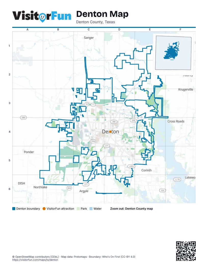
Street index of Denton
Each street on the sheet and the grid squares it crosses.
- North Loop 288C3, D3, D4
- West University DriveB4, C4, D4
- East University DriveE3, D4, E4
- Fort Worth DriveD4, C5, D5, C6
- North Elm StreetC3, D3, D4
- North Locust StreetD2, D3, D4
- South Loop 288D4, D5
- Barrel Strap RoadD5, D6
- Dallas DriveD4
- US Highway 380 EastE3, F3, F4
- State School RoadD5
- Eagle DriveC4, D4
- US Highway 380 WestB4
- Market StreetD4, E4
- North Elm Street ConnectorD3
- North US Highway 377C6
- North Interstate 35C2, C3, C4
- Teasley LaneD4, D5, D6
- South Interstate 35ED4, D5, E5
- South Bonnie Brae StreetC4, C5
- East McKinney StreetD4, E4
- South Mayhill RoadE4, D5, E5
- North Bonnie Brae StreetC3, C4
- Colorado BoulevardD4, D5
- North Interstate 35EC4, D4
- Hickory Creek RoadD6
- North Mayhill RoadE4
- North Carroll BoulevardD3, D4
- West Oak StreetC4, D4
- North Bell AvenueD3, D4
- East Sherman DriveD3, D4
- Farm-to-Market Road 428D2, E2
- Robson Ranch RoadB6
- Airport RoadC4
- Ryan RoadD5
- Country Club RoadD5, D6
- West Hickory StreetC4, D4
- South Locust StreetD4
- Lillian Miller ParkwayD5
- South Carroll BoulevardD4
- Farm-to-Market 2164D1, D2
- Robinson RoadD5
- South Woodrow LaneD4
- Mayhill RoadD5
- South Bell AvenueD4
- South Elm StreetD4
- West Sherman DriveD4
- Farm-to-Market Road 455E1
- Crawford RoadC6
- West McKinney StreetD4
- North Woodrow LaneD4
- Lake Sharon DriveD6
- Jim Christal RoadB4, C4
- Lakeview BoulevardE4, E5
- Mingo RoadE3, D4, E4
- John Paine RoadC5, C6
- Shady Oaks DriveD4
- Ed Robson BoulevardB5, B6
- Montecito DriveD5, D6
- West Windsor DriveC3, D3
- Farm-to-Market Road 2153E1, E2
- Milam RoadC2, D2
- Vintage BoulevardC5
- South Stemmons StreetC1, C2
- South Western BoulevardC4
- Brinker RoadD4, D5
- Hercules LaneC3, D3
- Edwards RoadE5
- Audra LaneD4
- Kings RowD3
- Stuart RoadD3
- East Windsor DriveD3
- East Hickory Hill RoadC6, D6
- Roselawn DriveC5, D5
- Bernard StreetD4, D5
- Paisley StreetD4
- Spencer RoadD4, E4
- Heritage TrailC4
- Nottingham DriveD3, D4
- Michelle WayB5, B6
- North Western BoulevardC4
- Avenue CC4
- Scripture StreetC4, D4
- Mockingbird LaneD4
- Creekdale DriveD5
- McCormick StreetC4, C5
- Morse StreetD4, E4
- Forrestridge DriveD5
- North Texas BoulevardC4
- Highland Park RoadC4, C5
- Pennsylvania DriveD5
- Malone StreetC4
- Ganzer Road WestB2, C2
- Wind River LaneD5
- North Ruddell StreetD4
- Willowwood StreetC4, D4
- Hobson LaneD5
- Southridge DriveD5
- West Sycamore StreetC4, D4
- Mistywood LaneD3, D4
- Mills RoadE4
- Pockrus Page RoadE5
- Allred RoadC5
- Fulton StreetD4
- Oakland StreetD4
- Interstate 35WC4, C5
- West Prairie StreetC4, D4
- Hinkle DriveD3, D4
- Brush Creek RoadC5, C6, D6
- San Jacinto BoulevardD4, D5
- East Hickory StreetD4
- West Congress StreetC4, D4
- Parvin StreetC5, D5
- Wheeler Ridge DriveD5
- East Sycamore StreetD4
- Old North RoadD3, D4
- Precision DriveC4
- Ector StreetC4
- Ponder StreetC4, D4
- East Prairie StreetD4
- Unicorn Lake BoulevardD5
- Avenue AC4
- Medpark DriveD5
- Clubhouse DriveD5
- Glenwood LaneD3, D4
- Ganzer Road EastC2, C3
- Robinwood LaneD3, D4
- Duncan StreetD4
- East Windsor StreetD3
- Pine Hills LaneD5
- Nicosia StreetC3
- Riverpass DriveD5, D6
- Shady Shores Road WestE5
- Cowling RoadC1, C2
- Prominence ParkwayD4, E4
- Russell Newman BoulevardD4, E4
- West Parkway StreetD4
- Shoreline DriveD5
- Lakey StreetD4
- Post Oak BoulevardE5
- Jagoe StreetC4
- West Shady Shores RoadE5
- North Avenue CC4
- Old Alton RoadD6
- Rector RoadB2, C2
- Bonnie Brae RoadC5
- East Congress StreetD4
- Rector Road CrossoverC2
- Palmwood PlaceD4
- West Windsor StreetD3
- North Welch StreetD4
- East Parkway StreetD4
- Cleveland Gibbs RoadB6
- Hartlee Field RoadD3, E3
- Panhandle StreetC4, D4
- Ridgecrest CircleD5
- UNT Discovery ParkC3
- Bolivar StreetD3, D4
- Tom Cole RoadB4, C4
- Crescent StreetC4, D4
- Crestview DriveB5, B6
- Masch Branch RoadC3, C4
- Westgate DriveC3
- Emerson LaneD3
- H Lively RoadB5
- Hollyhill LaneD5
- Linden DriveC4, D4
- North Trinity RoadE3, E4
- Grandview DriveB6
- Long RoadD3
- Marshall RoadC3, C4
- C Wolfe RoadB4, B5
- Riney RoadC3, D3
- Center Point Mobile Home ParkD5
- Drinkwater DriveB5, B6
- Blagg RoadE4
- Lovers LaneC3
- Bronco WayC3
- Thomas J Egan RoadB4
- Southerland DriveB6
- West Highland StreetC4, D4
- Cordell StreetC4, D4
- Emery StreetC4, D4
- West Mulberry StreetC4, D4
- Swisher RoadE5
- Lipizzan DriveD5, D6
- Cooper Creek RoadE3, E4
- Underwood RoadC5
- Shepard RoadE2
- Brookside DriveC6
- Maple StreetC4, D4
- Beall StreetC3, D3
- Stonegate DriveD5
- Barthold RoadC2, C3
- Greenwood DriveD4
- Kendolph DriveC4
- Argyle LaneC5
- Duchess DriveD4
- Lattimore StreetD4
- North Austin StreetD4, D5
- LandfillE4, E5
- Stallion StreetE4
- Yarbrough WayA6, B6
- Egan StreetC4, D4
- Thomas StreetC4
- Sundown BoulevardD5
- Lariat RoadC3, C4
- Corbin RoadC4, C5
- Winthrop Hill RoadC5
- Ed Robson CircleB6
- El Paseo StreetD5
- Frame StreetD4
- Westcourt RoadC4, C5
- Woodbrook StreetD5
- Parkplace DriveC6
- Dovetail LaneB6
- Perimeter StreetB5, B6
- Lynhurst LaneD5
- Alice StreetD4
- Lindsey StreetC4, D4
- Seven Oaks LaneD6
- West Collins StreetC4, D4
- Denton StreetD4
- Treatment PlantE4, E5
- Hampton RoadC3
- Lindenwood TrailB6
- Anna StreetD4
- Lighthouse DriveD6
- Foxcroft CircleD3
- South Welch StreetD4
- Georgetown DriveC3, C4
- Private Road 2718E2
- Lake Ray Roberts Dam RoadE1
- Poinsettia BoulevardD3
- Santa Monica DriveD5
- Orangewood TrailB6
- Leafy LaneE5
- Wellington DriveD3
- Goodland DriveB6
- Bryan StreetC4
- Yellowstone PlaceD3
- Camino Real TrailE5
- Fishtrap RoadE3
- Coit StreetD4
- Loon Lake RoadD5
- Bowling Green StreetC3, C4
- Athens DriveC6
- Texas StreetD4
- Ranchman BoulevardD5
- Cardinal DriveD4
- Bishop Pine RoadE5
- Elm Bottom CircleE2
- Burger RoadE1
- Granada TrailD5
- James StreetD5
- Gardenia DriveB6
- Hillcrest StreetC4
- Londonderry LaneD5
- Seahawk DriveB6
- Juno LaneD3
- Dakota LaneC4
- Mimosa DriveD3
- Warschun RoadE2
- Serenity WayD6
- Deer Meadow DriveB6
- Picadilly LaneD3
- Boyd StreetD4
- Warbird DriveD3, C4
- South Masch Branch RoadC4
- Pepperridge AvenueA6, B6
- Tuscan Hills CircleD5
- East Oak StreetD4
- North Wood StreetD4
- Coronado DriveD3
- Pembrooke PlaceD5
- Northridge StreetD3
- Old Bonnie Brae StreetC5
- Headlee StreetD3
- Magnolia StreetD3
- Heather LaneD3
- Broadway StreetC4, D4
- Cindy LaneC3, C4
- Nail RoadB4
- Parkside DriveC3, C4
- Rolling Meadow WayB6
- Club View DriveC6
- Thoroughbred TrailD5
- Westway StreetD4
- Johnson LaneC6
- Ewing WayE4
- Carmel StreetD5
- Virginia CircleD4
- Crestwood PlaceD3, D4
- Meandering Creek DriveC6
- Monte Carlo LaneD5
- Murray S Johnson StreetB6
- Cooper Glen ApartmentsD3
- Gober StreetC4
- Dunes StreetD3
- Swan Park DriveD6
Things to do on the Denton map
Places on the map
- Airport Road Park
- Avondale Park
- Bald Knob
- Bent Creek Park
- Borman Elementary School
- Buc-ee's
- CH Collins Athletic Complex
- Cross Timbers Park North
- Cross Timbers Park South
- Denton Bible Church
- Denton High School
- Denton Recycle Center
- Denton Square
- Denton State Supported Living Center
- Denton Town Center
- Evans Lake
- Golden Triangle Mall
- Guyer High School
- Harbert Mine
- Lake Forest
- Lake Forest Park
- Medical City Denton
- North Lakes Park
- Preserve at Pecan Creek
- Rayzor Ranch Marketplace
- Rayzor Ranch Town Center
- Roselawn Memorial Park
- Ryan High School
- Shiloh Field Community Garden
- South Lakes Park
- Southwest Open Space
- St. Mark Catholic Church
- Texas Woman's University
- Timberlinks Golf Course
- Unicorn Lake
- University of North Texas
- Wildcats Disc Golf Course
- Wildhorse Golf Course
- Wind River Park
Next to Denton
- Argyle
- Aubrey
- Corinth
- Cross Roads
- DISH
- Krugerville
- Northlake
- Ponder
- Sanger
© OpenStreetMap contributors, Open Database License, openstreetmap.org/copyright · Map data: Protomaps · Boundary: Who's On First (CC-BY 4.0); Quattroshapes (CC BY 2.0)