

Texas map
Fate map
About 27,467 people live here (Census Bureau, 2024 estimate). The sheet's index lists 300 streets; C.D. Boren Parkway, Congressman Ralph Hall Highway and West Holiday Drive cross the most grid squares. Also on it: Stodghill Lake, Joe Burger Park and May Veron Elementary.
Open the map (PDF, US Letter)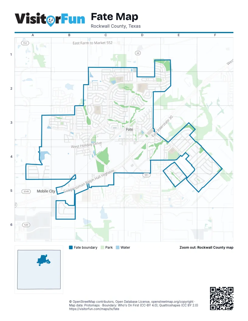
Street index of Fate
Each street on the sheet and the grid squares it crosses.
- Congressman Ralph Hall HighwayD3, C4, D4, B5, C5
- West Holiday DriveC3, D3, A4, B4, C4
- North William E Crawford AvenueD2, D3
- West State Highway 66D2
- State Highway 66A4
- East Interstate 30D3, C4, D4, B5, C5
- Fate Main PlaceC3, D3
- William E Crawford AvenueD3, D4
- South William E Crawford AvenueD3, D4
- Memorial ParkwayD4
- North Stodghill RoadA4, A5
- I-30 Frontage RoadD4
- C.D. Boren ParkwayC2, D2, E2, A3, B3, C3
- Woodcreek BoulevardC3, C4
- North Ben Payne RoadB3, B4
- Blackland RoadD3, E3, E4, E5
- Gettysburg BoulevardB5
- East Greenbriar RoadD4, E4
- West Fate Main PlaceC3
- Greenbriar RoadD4
- Chamberlain DriveD4
- Williamsburg ParkwayD4
- Prince LaneC1, D1, C2
- Rochell RoadB5, B6
- South Ben Payne RoadB4, B5
- Hampton DriveC3
- Riding Club RoadA5, B5
- Stevenson DriveC2, C3
- Grant DriveE3, E4
- Everly DriveD1, E1, E2
- Jenkinson DriveD4
- Carrington DriveB5, B6
- Margaret StreetE4, E5
- Laurel LaneD3
- Corbitt LaneD2, E2
- Decker DriveD2, E2
- Northview DriveE3, E4
- Highedge DriveA3, B3
- La Grange DriveC2
- Weston DriveE3, E4
- Meredith DriveC2, D2
- Curtiss DriveB3
- Brittany DriveE4, F4
- Gatecrest DriveA3, B3
- Aeronca DriveB3
- Bosley DriveC2
- Hackberry DriveC3, D3
- Fletcher DriveC1, C2
- Azalea DriveD3
- Jeremy DriveF4, F5
- Mustang DriveA4, A5
- Blue Sage DriveD3
- Cottonwood DriveE4, F4
- Jerome PrairieE4, F4
- Spirehaven DriveA3, B3
- Mangrove DriveC2
- Hudson StreetB4, C4
- Freed DriveC2, D2
- Blackhaw DriveC2, D2
- French StreetD2, E2
- Garner DriveC1, D1, D2
- North Churchill DriveE4
- Hankinson LaneD2, E2
- Red Oak DriveB3
- Butternut DriveC3, D3
- Miss May DriveC1, C2
- Conklin DriveD1, D2, E2
- Baxter TrailC2, B3, C3
- Sleepy Hollow DriveE4, F4
- Leonard WayC3
- Daisy DriveD3
- Packer DriveE4
- Roland DriveD2
- Fireberry DriveC2, C3
- C.B. Davidson AvenueD3, D4
- Mulberry DriveC2, C3, D3
- Valen DriveE4
- Magnolia DriveC3, D3
- Hickory LaneC2, C3
- Manuel DriveC2
- Derick DriveF4
- McKinney TrailC3
- Roscoe DriveC2, D2
- Westminster DriveB6
- Black Oak LaneD4
- Abelia DriveD2, D3
- Royal Pine DriveB3
- Betty DriveE3, E4
- West Black Oak LaneC4, D4
- Brown AvenueD3, D4
- Silktree DriveC2
- Katie StreetE4, E5
- Southview DriveE4, F5
- West Greenbriar RoadC4, D4
- Micco LaneB3, C3
- Julia DriveE3, E4
- Comet DriveB3
- Cascade Valley DriveA4, A5
- Airlene LaneB3, C3
- Equestrian TrailA4, A5
- Brisbon StreetD2
- Cauble DriveC3
- Florence DriveC2
- Hawthorn DriveC2, D2
- Appaloosa DriveA4, A5
- Pemberton ParkwayD2
- Taylor DriveC2
- Garrett RoadC3
- Dustin DriveF4, F5
- Headwater DriveB3
- Elmwood StreetB4, C4
- Bradley DriveC2
- Silver Leaf DriveD3
- Cox DriveB3, C3
- Willowbranch DriveB3, B4
- Honey Locust DriveD2
- Red Cedar DriveC2, D2
- Auburn StreetB4, C4
- Haley DriveF4
- Hawkins DriveD1, E1, E2
- Citrus DriveD2
- Sweetleaf DriveC2
- Louder WayC3
- Phillips CourtC3
- Sugarberry LaneC3
- Price DriveC3, C4
- Bryant LaneD2
- Payton WayC3
- Ruffian WayC3
- Stuart LaneE4
- Mildren LaneC1, C2
- Vernon DriveB3, C3
- White DriveB3, C3, B4, C4
- Windflower DriveD3
- Bluewood DriveC2, D2
- Pitt CircleE4
- Deaton DriveC2, C3
- Horton StreetD2
- Newby LaneD2
- Universal DriveE5, F5
- Wentworth DriveD4
- Clydesdale DriveA5
- Bayberry DriveC3, D3
- Layla DriveC2
- Water Tower RoadC4, D4
- Edmund LaneC2
- Sparks DriveA4
- Waxberry DriveD2
- West Cherry Tree LaneC3, D3
- Baldcypress DriveD2
- Sewell DriveE2
- Grisham DriveC2, C3
- McCall DriveC3
- Industrial DriveC5
- James StreetE4
- Larkspur DriveD3
- Shelby DriveF4
- Feverbush DriveD2, D3
- Beltrand LaneD2
- Holt LaneD2
- Sitwell DriveD2
- Hawks DriveC2
- Robinson WayE4
- Rivergate StreetB3
- Dehaviland LaneB3
- Walpole CourtD4
- Piper LaneB3
- Spring Branch DriveB3
- Western DriveE5
- Fargo PlaceC4
- Adrian DriveC2
- Fairchild DriceB3
- Thoroughbred DriveA4
- W T Barnes AvenueD3
- Parkford DriveB3
- Parsons StreetD1, D2
- Indian Paintbrush DriveD3
- Goff DriveE5
- Plains PlaceB3, B4
- Reynolds DriveC2
- Austero DriveD2
- Churchill DriveE4
- Lawless LaneC2
- Sawyer DriveC3
- Birch DriveC2
- Bleriot DriveB3
- Tribute PlaceB3, B4
- Cirrus LaneB3
- Coneflower DriveD3
- Riley StreetB4, C4
- Abbey LaneB5, B6
- Petty WayD3, D4
- Sundrop DriveD3
- Country View LaneE4
- Huckabay DriveE1
- Shady Springs LaneE4
- Norma GeneE4, F4
- Forestridge DriveB3
- Macdonald WayD4
- Tanglewood DriveD2
- Cliffmere DriveB3
- Butler AvenueB4
- Burkham DriveD2
- Kennedy CourtC2
- Stearman LaneB3
- Devonshire LaneE5
- E.R. Ellis AvenueC3, C4
- Plum Tree DriveC2, D2
- Reed DriveC3
- South Krider RoadE5
- Liner LaneC1, C2
- Lariat DriveA5
- Fitzroy LaneD3, E3
- Overwood DriveB3
- Blazing Star DriveD3
- Patterson CourtB3
- Sharpley DriveC3
- Costlow LaneD2
- Mac-West DriveE5, F5
- Mary StreetE4, E5
- Peel StreetD3, D4
- Richlands WayD3
- Hadley LaneD2
- Draper DriveD2
- Pepperwood DriveB4
- George DriveE5
- Cannon DriveC3
- Attlee DriveE5
- Vervain DriveD3
- Cayden CourtC2
- Eden DriveE4
- Kearley DriveB3
- Meushaw DriveB3, B4
- Collins LaneB3
- McKenna DriveC2
- Addington WayE3, D4
- Spur DriveA4
- Rockhill DriveA3
- Eleanor DriveC2
- McKee CourtC3
- Rosebay DriveC2
- Kara DriveC2
- Nixon DriveC2
- Chinaberry DriveD3
- Darst DriveD2
- Maplewood DriveD3
- Allison DriveC2
- Salisbury DriveE5
- Snakeweed DriveD2, D3
- Zeter DriveB4, C4
- Carrier DriveD2
- Talley DriveC2
- Belmont RoadB4
- Mason CourtC3
- Vance CourtC3
- Waller DriveC3
- Pincoffs DriveC2
- Rubin RoadD2
- Avery LaneE5, F5
- Barringer CourtC3
- Turner LaneC1, C2
- Sessions DriveD2
- Mistflower LaneD3
- Saddle DriveA4
- Fargo MewsC4
- Maule WayB3
- Bradfield LaneC3
- Gaines CourtC3
- Makesa CircleE3
- Equestrian CourtA4
- Atkins DriveD2
- Vester TrailC4
- Pilatus LaneB3
- McGehee CourtC3
- Dowell CircleB5
- Emma LaneF4
- Piatt CourtC2
- Evans DriveF4
- Greenhill LaneD3
- East Cherry Tree LaneD3
- West Elmhurst AvenueD3
- East Dogwood TrailD3
- West Dogwood TrailD3
- East Elmhurst AvenueD3
- Ella LaneC2
- Maple Hill DriveB3
- Stockton WayD2
- Lowry DriveB3
- Natures Point RoadB3
- Lantana DriveD3
- Harper DriveC3
- John StreetE4
- Apple Tree LaneC4
- Costley CourtE2
- Ronda RoadC2
- Big Bend DriveB3
- Twin Oak RoadB3
- Liscombe DriveC3
- Humphrey DriveC2
- Baynes WayB4
Places on the map
- Along Came Tamale
- Amy Foster Hair Salon
- Animal Hospital of Fate
- Avondale Amenity Center
- Billie Stevenson Elementary School
- Branded Customs
- Café Chamoy
- Carcineria Meat Market & Taqueria
- Chipotle
- Choice Heating & Air Conditioning
- Cowboy Cleaners
- Domino's
- Encounter Church
- Family Dollar
- Fate City Hall
- Fate Fire Station
- Fate Pharmacy
- Fate Post Office
- Fate Station Park
- Fate Village Tavern
- Fresh by Brookshire's
- Green Cleaning DFW
- Harry H. Herndon Elementary School
- Hustle & Glow
- Joe Burger Park
- Macedonia Missionary Baptist Church
- May Veron Elementary
- McDonald's
- Pioneer Technology and Arts Academy
- Sauce & Vine
- Scrubbies
- Smith Park
- Smoak Town BBQ
- Spec's
- Stags Carwash
- Stodghill Lake
- Taco Bell
- Whataburger
- Woodcreek Community Center
- Woodcreek Lakeside Park
Next to Fate
- Mobile City
© OpenStreetMap contributors, Open Database License, openstreetmap.org/copyright · Map data: Protomaps · Boundary: Who's On First (CC-BY 4.0); Quattroshapes (CC BY 2.0)















