

Texas map
Heath map
About 11,499 people live here (Census Bureau, 2024 estimate). The sheet's index lists 300 streets; Governors Boulevard, Smirl Drive and Horizon Road cross the most grid squares. Also on it: Buffalo Creek Golf Club, Rockwall-Heath High School and Linda Lyon Elementary School.
Open the map (PDF, US Letter)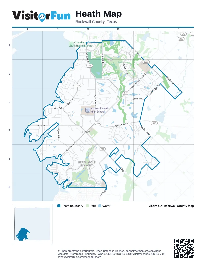
Street index of Heath
Each street on the sheet and the grid squares it crosses.
- Laurence DriveC2, C3, C4
- Ridge RoadC1, C2
- Farm to Market 549E2, D3, C4
- Horizon RoadD1, E1, E2, F2
- McLendon RoadC4, D4, E4
- Bois D'ArcC4, C5, D5
- FM 740C5, D5, D6
- Buffalo WayD3, C4
- South Farm to Market 549E2
- West FM 550E4
- Governors BoulevardC4, B5, C5, B6, C6
- Smirl DriveC2, B3, C3, B4, C4
- Country Club DriveC1, D1, D2
- Heathland CrossingC2, D2, D3
- Hubbard DriveC4, B5, B6
- White RoadC1, C2, D2
- Kings PassD1, D2, E2
- Trophy DriveC5, C6, D6
- Chris Cuny ParkwayC3, C4
- McDonald RoadE4
- Heath Hawk DriveC3
- South King RoadD5
- King RoadD5
- Henry M Chandler DriveC1
- Tubbs RoadC1
- Rabbit Ridge RoadE2, F2, E3, E4
- Terry LaneA4, B4, C4
- Yorkshire DriveD4
- Wyndemere BoulevardC3
- Chippendale DriveC3, D3
- Shepherds Glen RoadB2, C2
- Myers RoadB4
- Moraine WayB3
- Fallen Timber DriveB5
- Cornerstone LaneB5, C5
- Falcon Point DriveE4, E5
- Stoneleigh DriveD4, D5
- Bison Meadow LaneE2
- Mockingbird LaneE5
- Twin View RoadB2, B3, C3
- Scenic DriveB5
- Mariah Bay DriveB2, C2
- Bevan CircleE2
- Rabbit RidgeE4
- Berkshire DriveD4
- Dennis Bailey LaneE2, E3
- Cove Ridge RoadB2, C2
- Meadowview RoadB3, B4
- Lowe RoadD3, E3
- James DriveA5, B5
- Rush Creek DriveB5
- Lakeway DriveC1
- Brentwood DriveD4, E4
- Yankee Creek RoadB4, B5
- Blue Heron LaneC2
- Old Vineyard LaneE2
- Ridgemont RoadD5
- Lafayette LandingC1, C2
- Keystone BendD2, D3
- Crestridge RoadC3, D3
- Meadowlake DriveB3
- Dunford DriveC4, C5
- Lodge Hill DriveE2, E3
- Yellow Jasmine LaneC6
- Normandy LaneC4
- Hanby LaneF2
- Drew LaneA5, B5
- Harvest Hill DriveD2, E2
- Wilford WayD2
- Crisp RoadB4, B5
- Ridge Point RoadD4, D5
- Avalon DriveD2
- Willow Springs DriveC2, D2
- Noe BoulevardB6
- Faith TrailD2
- Larry DriveC4
- Darr RoadB3
- Providence WayD3
- Halford DriveC2
- Loma VistaC3, D3
- Starlight PassD2
- Lafayette DriveC1
- Las Lomas DriveC3
- Tennis Village DriveD1
- Lemley DriveA4
- Mallard CrossingD2
- Wellington LaneC1
- Shadow Wood LaneD2
- Dominion PlaceB4, C4
- Woodbridge PlaceC2, B3, C3
- Zurek LaneC5
- Cedar Tree LaneC3
- Kyser Spring RoadC1, D1
- Luther LaneA4, B4
- Meadowlark PlaceB4
- Timberline DriveD1, E1, D2
- Sunset Point TrailE2
- Candlelite TrailA4
- Carriage Hill LaneC3
- Cedar Glen TrailB2, B3
- Morrish LaneE2
- Sunrise Ridge DriveE3
- Castle Pines DriveD2
- Linda LaneB5
- Cedar Shores DriveB2, B3
- Yacht Club RoadA5, B5
- Saint Andrews DriveD2
- Canal StreetB6
- Briarcrest CircleB3, B4
- Gregory DriveA4
- Hillview DriveC2
- Jeff Boyd RoadE2, F2
- Tranquility DriveB3, B4
- Manor DriveE2
- Bristol CourtE4
- Renaissance LaneC3
- Stafford DriveE4
- Sanctuary WayB3, C3
- Sonnet DriveB5, C5
- Sawgrass DriveD2
- Cedar Ridge RoadB2
- Chaps DriveC2, C3
- Kings LandingC3
- Kingsbury TrailC3
- Summer Tanager LaneC2
- Old Ridge RoadC2
- Key DriveB3
- Valley TrailB2
- Heath DriveA5, B5
- Eagle PassD1
- Serenity LaneC1
- Ambrosia LaneB4
- Forest DriveB4, C4
- Fairway CircleC1
- Stanford CourtC4, C5
- Autumn TrailA4
- Parkview DriveE2, E3
- West Sorita Drive WestB3
- Torrey Pines CircleC2, D2
- Lee DriveB5, C5
- Michael DriveB5, C5
- Falcons View PassD2
- Longview PlaceE2
- Cambridge DriveC1
- Brooks TrailC5
- Sorita CircleB3
- Darrell DriveA4
- Rustic Ridge DriveE3
- Native TrailD1
- Peninsula CourtA4
- McCrummen LaneC4, C5
- Broadmoor DriveC2, D2
- Sorita Circle NorthB3
- Fossil Bay CourtB6, C6
- Crystal CourtB4
- Carolina Cherry DriveC6
- Tatum PlaceD3
- Knollcrest TrailB2
- Kathryn DriveC1
- Windward TrailB2
- Timber Cove PlaceE2
- Golden Bell CourtC6
- Knights TrailC3
- Racheal DriveC1
- Terrabella LaneB3
- Chatham PlaceE4
- Peninsula LaneA4
- Reba RoadB5
- Brockfield CourtB5
- Marys GlenB2
- Noble CourtE2
- Ridge Point CircleD5
- Weiskopf DriveE2
- Siesta CircleD2
- Rosemary DriveB3
- Oxford DriveC1
- Craig DriveA5, B5
- Hallelujah DriveB6
- Calvin DriveC5
- Scenic PlaceB5
- Mont Blanc DriveC1
- Wabash CourtC6
- Majestic Point DriveD1, D2
- Johnson CourtC5
- High Meadow LaneC3
- Hope DriveE2
- Kensington DriveD4
- Psalm CircleC6
- Haciendas Del LagoC2
- Isaiah CourtB6, C6
- Overlook DriveB3
- Liechty CourtD1
- Moraine PlaceB3
- Dove Hill CircleD3
- Stonewall TrailB2
- Pintail PointC1, C2
- Center CourtD1
- Keswick CourtC3
- Raven CircleE5
- South Sorita Drive SouthB3
- Covenant CourtD3
- Buckingham DriveC1
- Skyline CircleB5
- Peregrine CircleE5
- Pine Island CircleC2
- Paradise CourtC5, D5, C6
- Sunset TrailC2
- Kenton CourtC3
- Sleepy Hollow LaneD1, D2
- Spring Meadow TrailD1, E1
- Clover CourtC5
- Horizon CourtE1
- Brighton CourtD4
- Montserrat CircleB3
- Toulouse LaneC4, C5
- Cypress CourtC2
- Versailles DriveC1
- Wimbledon CourtD1
- Eloise DriveC5
- Green Pasture RoadC2
- Enclave CourtB4
- White Buffalo LaneD1, D2
- Saint Anne CourtD3
- Rabbit Ridge CourtE3
- Hero TrailB6
- Dwyer CourtC1
- Moses DriveC5
- Sandra DriveC2
- Bechtol DriveB5, C5
- Spyglass CourtD2
- Tea Olive DriveC6
- Eisley PlaceC5
- Dover LaneD4
- Berry CourtC6
- Chinese Fir DriveC6
- Waters Edge CourtD2
- Bright Meadow RoadC2
- Chelsea PlaceC5
- Flowering Peach DriveC6
- Eastshore RoadC2
- Andrews DriveE2
- Bay Valley CircleB2
- Deep Water CourtC5
- Cheshire CourtD4
- Glen Abbey CourtD3
- Wiltshire CourtD4
- Emerald CoveB5
- Manor CourtE2
- Long Irons CourtC5
- Woodmont CircleC1
- Mariah Bay CircleB2, C2
- Debracie CourtC5
- Lee CircleC5
- Windlake CircleD3
- H Wallace LaneE2
- Legend DriveD1
- Bridle Path CourtD1
- Chilton PointA5
- Kingsford CourtC3
- Shepherds WayC1, C2
- Signature CourtD2
- Kerimore CourtC3
- Lantern DriveD2
- Promise DriveB5
- Resort DriveC6
- Kendal CourtC3
- Urbine CircleC1
- Lamberth CourtC6
- Chantilly CourtC1
- Standing Tall CourtC6
- Westchester CourtD4
- Firethorn DriveC6
- Morris CrossingB5
- Camden CourtD4
- Integrity CourtC5
- Versailles CourtC1
- Kolton DriveC4
- Rockingham CourtD4
- Abundant CourtC5
- Bay Crest TrailB2, C2
- Sheffield CourtD4
- Bountiful CourtC5
- Bay CourtB2
- Yasmine CourtC6
- Ambassador CourtC5
- Holloway LaneE3
- Lago CircleC3
- Victoria PlaceB5, B6
- Favour CourtC5
- Foxborough CourtC4
- Juniper CourtC6
- Ridge Point DriveD5
- Stillwaters DriveC1, C2
- Landmark PlaceC6
- Kestrel CourtC3
- Double Eagle CourtC5
- Mariah CourtC2
- Coopers BluffD2
- Kingfisher LaneE4
- Meadowview CourtB4
Places on the map
- American National Bank of Texas
- Amy Parks - Heath Elementary School
- Amy Parks-Heath Elementary School
- Animal Hospital of Heath
- Buffalo Creek Golf Club
- CVS Pharmacy
- Dorothy Smith Pullen Elementary School
- First Baptist Church - Heath
- First Baptist Church of Heath
- First United Methodist Church of Heath
- Governors Boulevard
- Heath Hawks Baseball Field
- Heath Lady Hawks Softball Field
- Heath Methodist Church
- Heath Police Department
- Heath-Willow Cemetery
- Holy Trinity Episcopal Church
- Horizon Lighthouse Private School and Childcare Center
- Kyser Cemetery
- Kyser-Peck Cemetery
- Linda Lyon Elementary School
- Maurine Cain Middle School
- Precision Plumbing NTX
- Rockwall-Heath High School
- Shell
- Standard Service
- Sterling Rex Barnes
- The Church of Jesus Christ of Latter-day Saints
- Tom Thumb
- Tom Thumb Express
- Tom Thumb Pharmacy
- U.S. Post Office
© OpenStreetMap contributors, Open Database License, openstreetmap.org/copyright · Map data: Protomaps · Boundary: Who's On First (CC-BY 4.0); Quattroshapes (CC BY 2.0)















