

Texas map
Kerrville map
About 25,141 people live here (Census Bureau, 2024 estimate). The sheet's index lists 300 streets; Veterans Highway, Bandera Highway and State Highway 27 cross the most grid squares. Also on it: Comanche Trace, Kerrville Landfill and Kerrville Schreiner Park.
Open the map (PDF, US Letter)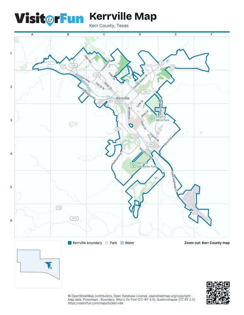
Street index of Kerrville
Each street on the sheet and the grid squares it crosses.
- Veterans HighwayD1, D2, E2, D3, E3, D4
- Junction HighwayA1, B1, B2, C2
- Bandera HighwayC3, D3, D4, E4, E5
- Sidney Baker StreetD1, E1, C2, D2
- Thompson DriveB1, B2, C2, C3
- Sidney Baker Street SouthC2, C3
- Fredericksburg RoadE1
- State Highway 27D4, E4, E5, E6, F6
- Holdsworth DriveC1, C2, D2
- Memorial BoulevardD3, D4
- Harper RoadC1, C2
- West Main StreetC2
- Medina HighwayC3, C4
- Goat Creek RoadB1, B2
- Cypress Creek RoadD2
- Main StreetC2, D2, D3
- BroadwayD3
- Golf AvenueD2
- Water StreetC2, D2, D3
- East Main StreetD3
- Coronado Drive NorthB1, C1, B2
- Riverhill BoulevardC4, D4
- Jackson RoadC1, C2
- Spur 100E3, D4, E4
- Tivy StreetD2, D3
- Legion DriveD3, D4, E4
- Benson DriveD1, E1
- Leslie DriveD1, D2
- West Water StreetC2
- Glen RoadB1, C1
- Aransas StreetD2, D3
- Francisco Lemos StreetC2
- Francisco Lemos Street SouthC2
- Ranchero RoadC3
- Comanche Trace DriveD5, E5, D6
- Lois Street NorthB1, B2, C2
- Airport LoopE5, F5, F6
- Jefferson StreetC2, D2, D3
- Town Creek RoadC1, C2
- Guadalupe StreetC2
- Singing Wind DriveD3
- Methodist Encampment RoadB1, C1, B2
- Arcadia LoopA1, B1, B2
- 1966 SouthA1
- Lytle StreetD2, D3
- Yorktown BoulevardD1, D2
- Acorn BoulevardD3
- Bluebonnet DriveC2
- Peterson Farm RoadE5
- La Cumbre DriveD5
- North StreetD2, D3
- Travis StreetD3
- Lake DriveC1, C2
- Washington StreetD2, D3
- Oakland Hills LaneD3, D4
- West LaneB1, C1
- Landfill RoadD3, E3
- Barnett StreetD2
- Riverside DriveD4, E4
- Crestwood DriveB1, C1, B2
- Oak Hollow DriveD4
- Mack Holliman DriveD4
- Fairway DriveC3, D3, D4
- Meadow View LaneD3
- Paschal AvenueC2, D2
- Vista Ridge DriveD2, E2
- Englewood DriveC4, D4
- North Lewis AvenueC2
- Roy StreetD2
- Louise Hays Park RoadC2, C3
- Olympic DriveD3, E3
- Bow LaneD3
- Stadium DriveD2
- Clay StreetC2, D2
- Earl Garrett StreetD2
- East LaneC1
- Ford StreetD2
- Trinity Circle SouthC2, C3
- Galbraith AvenueC2
- Hill Country DriveC2, C3
- Park StreetD3
- Spring Mill DriveC4, D4
- Summit Crest DriveE2
- Quinlan StreetC2, D2
- Ross StreetD2, D3
- Meeker RoadD3, D4
- Donna Kay DriveD2
- Woodlawn AvenueC2
- Lakewood DriveD4
- West Schreiner StreetC2
- 1st StreetD3
- Valley DriveB1, C1
- Warbler DriveC1
- Summit Ridge DriveE2
- Westcrest DriveB1
- Bluebell RoadC2
- 3rd StreetD2, D3
- Stephanie DriveB1, B2
- Wheless AvenueD2
- Barbara Ann StreetD2
- Myrta StreetD2
- Pinnacle Club DriveD5
- Toscano WayD5
- Sweeper LaneC1, C2
- Fairview DriveC2
- Hays StreetC2, D2
- Mount Laurel TrailB1, C1
- Al Mooney RoadE5
- Hilltop RoadC1
- Stone Creek CircleD6
- Stoneledge DriveD2, E2
- Peterson DriveD2
- Mockingbird LaneC1
- Gilmer StreetD2, D3
- Bobwhite DriveC2
- Westminster StreetD3
- Tomahawk TrailD3
- Sand Bend DriveC4, D4
- Rock Creek DriveD4
- Schreiner StreetC2, D2
- McFarland DriveC2, D2
- Riverhill Club LaneD3
- Nichols StreetD4
- Foothills DriveB1, C1
- Clearwater PaseoD3
- Whiskey Ridge Trail NorthE1
- Leland StreetC2
- Panorama DriveC1
- Hummingbird LaneC1, C2
- 2nd StreetD2, D3
- City Farm RoadD3, E3
- Cully DriveC2, C3
- 5th StreetD2
- Highlands DriveD4
- Everett StreetD3
- Oak Park DriveD5
- Cardinal DriveC1, C2
- Highridge DriveC3, D3
- Cailloux BoulevardC1, D1
- 4th StreetD2
- Trull Lane NorthD3
- Athens AvenueB1
- Pennacle View DriveD6
- Oak Valley DriveD4
- Beech StreetD3, D4
- Fox Run LoopD4
- Florence StreetC2
- Acrotech Loop NorthD2
- LDB Corp Drive SouthC3
- Trail Head CourtD5
- A StreetD3
- San Jacinto DriveD3
- Tanglewood LaneC1
- Pershing AvenueC2
- Overhill DriveC1
- Elm StreetC2
- Robinson AvenueD2
- Mill Run WestA1
- Rolling Green DriveD4
- Virginia DriveC1, C2
- Mae DriveD2
- Goss StreetD3, D4
- Antelope TrailD4
- Park LaneC3
- West Barnett StreetC2
- Village DriveC1
- Sheppard Rees RoadC2
- Indian Wells Drive EastD5, E5
- South Lewis AvenueC2
- Manor DriveC1, B2
- Circle AvenueC2
- Homestead DriveB1
- Jack DriveC1, C2
- Carol Ann DriveD2
- Saint Andrews LoopC3, D3, C4
- Tivy Mountain Road NorthD2
- Quinlin Creek DriveD2
- Swigert StreetC2
- Nancy Beth DriveD2
- Chaparral DriveC3, D3
- Old FM 689D4
- Summit Top DriveE2
- OttilieC2
- North Center AvenueC2
- Trail EndD3
- G StreetD3
- Thurman StreetD2
- Victory LaneD2
- Hugo StreetC2
- Arrowhead CourtD5
- Birkdale LaneD4
- Woodcrest DriveC2
- Summit SpurE2
- Webster AvenueC2
- Valencia DriveB1
- Winged Foot LaneD4
- Wallace StreetC2
- Gulberson AvenueC2
- Jefferson Street WestC2
- Rock Barn DriveD5
- Fawn Hide-A-WayD4
- Ranch View CourtD5
- Plaza DriveC2
- Candice Drive NorthB1
- Pecan GroveD3
- Oak Hills DriveB1
- Los Cedros LoopC2
- Vicksburg AvenueD2
- Jasper LaneD3
- College StreetD2, D3
- East Sunset DriveB2, C2
- Ivy LaneD3
- Patton AvenueC2
- Willow WayE5
- Terrace Lane EastD3, C4, D4
- Overlook DriveC3, D3
- Canyon Creek LaneD3, C4, D4
- C StreetD3
- Crescent DriveC1, C2
- Kite DriveD5
- Sabina Street SouthC2
- Lime Creek RoadB1
- Lowry StreetC2
- Mathison Street NorthD1
- Dry Hollow DriveD5
- Bulwar AvenueD2
- East Davis StreetC2, D2
- Harper StreetC2
- Pearl StreetC2, D2
- Stephen StreetC2
- Lammers StreetD4
- Rio Robles DriveC3, D3
- Hillside DriveC1
- D StreetD3
- Erin Drive NorthB1
- IreneC2
- Loma Linda DriveC3, D3
- Marion DriveD2
- Colorado Street SouthC2, C3
- Miller StreetC2, D2
- Clubhouse RoadD5, D6
- Alpine DriveD1, D2, E2
- Lee StreetC2
- Stone Creek DriveD6
- Agarita StreetD3
- Rees StreetC2
- South StreetD3
- Eggars LaneA1
- Timber Ridge RoadB1
- Cedar Mill RoadA1
- Forest Ridge RoadB1
- Sailing WayD3
- Happiness Road NorthE4
- Milton StreetC2
- Edinburgh DriveD2
- 1305 NorthC1
- Pinnacle View DriveD6
- West Sunset DriveB2
- Lowrance DriveD1
- Norfolk LaneD2
- B StreetD3
- Jennings BoulevardD4
- Oak StreetD2
- Crown Ridge DriveE2
- Brian DriveD1, D2
- Pecos Drive SouthC2, C3
- Rawson StreetD3
- Hillcrest AvenueD2
- Linda Joy DriveD2
- Remschel AvenueD2
- Texas DriveC2
- Hunt StreetD3, D4
- Prescott StreetD2
- Ruth StreetC2
- Josephine StreetC2
- Lucille StreetC2
- McAllen StreetC1
- E StreetD3
- G Street SouthC3, D3
- Kimberly DriveA1
- Country Club DriveD2
- Deer TrailD3
- North Lehmann DriveC3
- Margaret DriveC2
- Gloucester PointD2
- Cotton Gin Lane WestA1
- Pecan StreetC2
- Ridgewood DriveD4
- Degrasse DriveD2
- Spence StreetC2
- F StreetD3
- Moore StreetD2
- Locust StreetD3
- 1342 NorthC1
- Commerce StreetC2
- Poplar StreetD3
- Fifer StreetC2
- Castle Pines DriveC4, D4
- Meadow Ridge DriveB1
- Maple StreetD3
Places on the map
- Acorn Boulevard
- Antler Stadium
- B.T. Wilson Sixth Grade School
- Camp Meeting Creek Reservoir
- City South
- Comanche Trace
- Country Club Plaza
- Elm Creek Park
- Green Hills Shopping Center
- Guadalupe Park
- Hal Peterson Middle School
- HEB Municipal Tennis Center
- Hillcrest Inn
- Junction Plaza
- Kerr County Juvenile Probatoin
- Kerr County Road & Bridge
- Kerrville Landfill
- Kerrville Recycling Center
- Kerrville Schreiner Park
- Kerrville Sports Complex
- Kerrville State Hospital
- Kerrville VA Medical Center
- Kerrville-Schreiner Park
- Kerrville-Schreiner Park Hillside
- Kerrville/Kerr County Airport at Louis Schreiner Field
- Kroc Center
- LDB Corporation
- Lehmann-Monroe Park
- Live Oak Plaza
- Lois Park
- Louise Hays Park
- Lowe's
- Lowry Park
- Nimitz Lake
- River Trail RV Park
- Riverhill Country Club
- Scott Schreiner Golf Course
- Singing Wind Park
- Tivy High School
- Yogi Bear's Jellystone Park
© OpenStreetMap contributors, Open Database License, openstreetmap.org/copyright · Map data: Protomaps · Boundary: Who's On First (CC-BY 4.0); Quattroshapes (CC BY 2.0)















