

Texas map
Kerr County map
About 53,900 people live here (Census Bureau, 2024 estimate). The sheet's index lists 300 streets; State Highway 39, Junction Highway and State Highway 41 cross the most grid squares. Also on it: Kerr Wildlife Management Area, Camp Flaming Arrow and Camp La Junta for Boys.
Open the map (PDF, US Letter)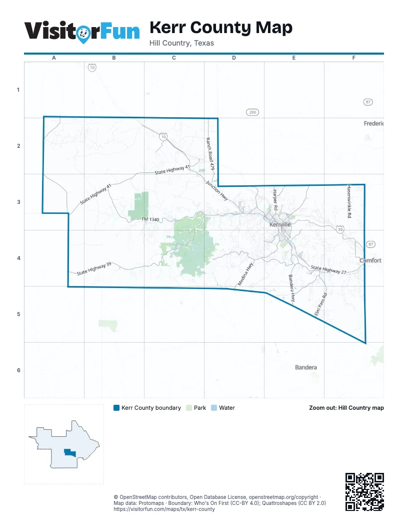
Maps inside Kerr County
1 map inside, from the street map of Kerr County down.
Street index of Kerr County
Each street on the sheet and the grid squares it crosses.
- State Highway 39C3, D3, A4, B4, C4
- Junction HighwayB2, C2, C3, D3, E3
- State Highway 41B2, C2, A3, B3
- Texas Vietnam Veterans Memorial HighwayA1, A2, A3
- Bandera HighwayE4, E5
- Fredericksburg RoadE3
- Veterans HighwayE3, E4
- Thompson DriveD3, E3
- Sidney Baker StreetE3
- Sidney Baker Street SouthE3, E4
- Cypress Creek RoadE3, F3, F4
- FM 1340B3, C3
- State Highway 27E4, F4
- Medina HighwayD4, E4, D5
- Ranch Road 479D2, D3
- Goat Creek RoadD3, E3
- Farm-to-Market Road 1340C3, D3
- Lower Turlte Creek RoadD4, E4
- Harper RoadE3
- Ranch Road 480E4, E5
- Holdsworth DriveE3
- Memorial BoulevardE4
- Main StreetD3, E3
- West Main StreetE3
- San Antonio StreetE4
- BroadwayE3, E4
- Golf AvenueE3
- Ranch Road 187B4, B5
- Upper Turtle Creek RoadD4
- Elm Pass RoadE4, F4, E5, F5
- I-10 Frontage RoadC2
- Center Point River RoadE4
- Bartel RoadF4
- Ranchero RoadD4, E4
- Midway RoadC2
- Spur 100E3, E4
- McCoullough Ranch RoadE3
- Skyline DriveE4
- Wharton RoadE4
- Kerrville Country DriveE3
- Coronado Drive NorthE3
- Goat Creek Road CutoffD3
- Water StreetE3, E4
- Farm to Market Road 1350E4, F4
- East Main StreetE3, E4
- Riverhill BoulevardE4
- Jackson RoadE3
- Leslie DriveE3
- Tivy StreetE3
- Legion DriveE4
- Benson DriveE3
- West Water StreetE3
- Glen RoadE3
- Aransas StreetE3
- Francisco Lemos StreetE3
- China StreetE4
- Crossing StreetE4
- Francisco Lemos Street SouthE3
- Interstate 10 EastB1
- Camino Real Road NorthwestA2, B2
- Hasenwinkle RoadF3, F4
- Stoneleigh RoadE4, F4
- Cummings RoadA2, B2
- Bear Creek RoadD3, D4, F4, F5
- Y O Ranch Road NorthwestA2, A3, B3
- Felix Fisher Road SouthC4
- Byas Springs RoadC3, D3
- Bobby Shelton Ranch Road NorthwestA4, B4
- Fall Creek RoadD4, E4
- B F Klein Ranch Road SouthwestB3, B4
- Lazy Valley RoadE4, F4
- Live Oak RoadB2
- Eagle Ridge RoadE4, E5
- Tommy Burrus Ranch Road NorthwestB2
- East Camino RoadB2
- Weatherby RoadC2
- Kerr WMA Road WestB3, C3
- Lower Reservation Road NorthwestC2, D2
- Honey Creek RoadC3, C4
- Wilson Creek RoadF4
- Sheppard Rees RoadD3, E3, D4
- 3017 NorthwestC2
- McDonald LoopE4, F4
- Arlitt Ranch Road SouthwestC3, C4
- Auld Road SouthC4
- Elm Pass 2 RoadE5, F5
- Whiskey Canyon Ranch RoadE3
- Bobcat Road WestB3
- Ingram Hills RoadD3
- Hermann Sons Road EastF4, F5
- Black Bull RoadB2, B3
- Verde Creek RoadE5
- Louis Real Road SouthC4, D4
- Comanche Trace DriveE4
- Inspiration LoopF3
- Casa Road NorthwestC4
- Twin Springs Road NorthE4
- Live Oak Road NorthwestB2
- Keidel Rand Road NorthE3, F3
- Wallace Creek RoadD4, D5
- Adudad RoadB2
- Aime Real Ranch Road SouthD4
- Old Headquarters Road SouthwestC4
- 2480 NorthF3
- Coldwell LaneE4
- Fallow Run RoadC3
- Leinweber Ranch Road SouthwestB3
- Kelly Creek RoadD3, D4
- Hyatt Mill RoadB2
- Stowers Ranch Road SouthwestB3
- East Lane Valley Road EastF4, F5
- Scenic Hills RoadE3
- Overland Trail WestC3
- Kemp Road WestC2, C3
- Downing RoadD4
- Scenic Valley RoadE3
- The Y O Ranch RoadA2
- Faltin Road NorthE3, E4, F4
- Saddle Wood LaneD3
- Bushwhack RoadD4
- Echo Hill Road SouthD4, D5
- Bluff Creek Road NorthF4
- Lane Valley RoadF4, F5
- Dale Priour Road WestC2, C3
- Camino RealD4, E4
- Hidden Hills Ranch Road EastE4
- Witt RoadE4, E5
- Paseo Vista Drive SouthwestC3
- Allerkamp Road NorthF3
- (S) Schultz Lane NorthE3
- Settlers Way NorthF3
- Elkhorn Circle NorthwestC2, D2
- Center Point DriveF4
- Indian Creek RoadD3
- Clark Ranch Road WestB3
- Carpenter Road NorthwestC2
- Roberts Road NorthF3
- East Spicer DriveD4
- Morris Ranch RoadC2
- Stoney Brook RoadE3
- Taylor RoadE4
- Lane Valley Road EastF5
- East Y O Ranch RoadA2, B3
- LandmarkD4
- Henry Priour Ranch Road WestB3
- Cypress Estates Parkway WestD3
- Schultz Ranch Road NorthE3
- Tegner Creek Road SouthD3, D4
- Colinas Drive SouthD4
- Moon Path SouthwestC4
- Glen Oaks Ranch Road NorthwestC2
- Cade Loop SouthD3
- Pass Creek Road EastE4
- Eggars LaneD3
- Kothmann Road WestB1, B2
- Schultz RoadE3, F3
- Lois Street NorthE3
- Ranch House Loop NorthE4
- Coker RoadD4
- Rowland Walters Ranch Road SouthwestB3
- Redbird LoopE4, F4
- Stablewood Springs Drive WestD3
- Ranch Rim RoadD3
- Ace Reid RoadE3
- Yellowstone Lane SouthwestC4
- Town Creek RoadE3
- Primrose RoadD3
- River Bend Road WestC3
- Dominion Ranch Road NorthwestA2
- Kingsing RoadC2
- Cattle DriveC2
- Lange Ravine Road SouthwestC3
- Lower Bee Cave RoadC3, C4
- Pikes Peak RoadD4
- Schladoer RoadF4
- Fossler Ranch Road WestB3
- Don Priour Road WestC3
- South Fork Road EastF4, F5
- Elm Waterhole RoadB2
- Pot Luck R C RoadC4
- Connie Lane SouthD3
- 1419 NorthF3
- Madrona DriveE4
- Bloys Road NorthwestC2
- 3019 NorthwestA2
- Cool Creek RoadE4, E5
- Airport LoopE4
- Seago RoadC4
- Two Dot Lane NorthwestA2
- Japonica Road SouthwestC3
- Gaddis BluffF4
- Big Buck CircleC2
- Mary Ruth RoadD4
- West Wind RoadE4
- Sky Harbor RoadC2
- 1496 NorthE4
- Rocky Top Drive SouthwestB4
- Hermann Sons RoadF4
- Dove Valley Drive NorthF4
- Esquell Ranch Road NorthwestC2, D2
- Crawford LaneC3
- Johnson Creek RoadA2, B2
- Saddle Club DriveE4
- Earl Garrett Ranch RoadB2, C2
- Armadillo Trail Drive EastF4, F5
- Bee Cave RoadA2, C4
- Calcote RoadD4, E4
- Cardinal Hill RoadD3
- 2404 SouthwestB3, C3, B4
- Wood TrailD3, E3
- Beals RoadC3
- Cherry Springs RoadC3
- River Valley Road SouthD3
- Camino RoadB2
- Center Point RoadF3, F4, F5
- Fritz Drive NorthF3
- 3026 NorthwestC2
- Northwest Hills DriveE3
- Double Mill Road WestB2
- Skyview DriveD3
- Klein Branch RoadD2
- Wh Cowden Ranch Road NorthwestB3
- Whiskey Ridge Trail NorthE3
- River RoadC3, D3, F4
- 2455 NorthwestB1, B2, C2
- 1101 EastD4
- Jefferson StreetE3
- Lazy Lane Ranch RoadC4, D4
- Reservation RoadD2
- Holloman Road NorthD3
- Horizon BoulevardE3, D4, E4
- Guilanshah RoadF3, F4
- Tegner Ranch RoadD3
- Riverside DriveE4
- Thomas Ranch Road NorthwestC2
- Wren RoadD3, E3
- Ranchland DriveC2
- Hoof Beat TrailD4
- 1616 NorthwestC2
- 2452 NorthwestC2
- 2488 SouthD3
- Headquarters Road NorthwestA2
- Hugo Real Ranch RoadD4
- Derrek Road SouthD4
- Johnson DriveE4
- George Hollow Road NorthD3, E3
- Camino Real RoadA2
- 2035 SouthwestC4
- Keith BoulevardD4
- Duderstat Byway Road WestC3
- Roane RoadF4
- Patio Ranch Road WestC3
- Rimrock RoadE3, E4
- Oak Wood Road EastE4
- Burney LaneE4
- 1569 NorthE3, E4
- Freedom Trail RoadD3
- Creekwood Road NorthE4
- Sanders RoadE5
- Peterson Farm RoadE4
- Higbee RoadD3
- Dry Pasture Road NorthwestB2
- Wyatt Ranch RoadF5
- Apache Springs Ranch Road WestC3
- Whiskey Canyon Ranch Road NorthE3
- 2454 NorthwestC2
- 2482 SouthD3
- Southway DriveE4
- 2451 NorthwestC2
- Burrus Ranch Road NorthwestC2
- Duderstadt Ranch RoadC2
- Indian Creek Road SouthD3, D4
- Faltin Ranch RoadE3, E4
- 2453 NorthwestC2
- Ellerbracht Road WestC2
- Elm Waterhole Road NorthwestA2, B2
- Denlu RoadD4
- Fisher Ranch RoadC4
- Enchanted Valley RoadD3, E4
- Faulkner Road SouthB4
- Kimble County Road 111 NorthwestA1, A2
- Philley's RoadC2
- Spring Lake RoadF3
- Guadalupe StreetE3
- Meadows RoadD3
- Broken Arrow Trail SouthD3, D4
- Silver Hills RoadE4
- Four Bears TrailD4
- SoutherlandE4
- Rio Vista Road SouthD3
- 2458 NorthwestD2
- 2487 SouthD3
- Willow Bend DriveE4
- Johnson RoadE5
- 1087 EastF5
- Lower Dietert RoadF4
- Ringtail Road WestB3, C3
- Cutbirth DriveD3
- Lange Lane EastF5
- Deer Park RoadE4
Places on the map
- 2352 Southwest
- 2394 South
- Acorn Boulevard
- Bonnie Belle Lake
- Camp Flaming Arrow
- Camp La Junta for Boys
- Camp Meeting Creek Reservoir
- Camp Mystic Cypress Lake
- Camp Mystic Guadalupe River
- Camp Rio Vista & Camp Sierra Vista
- Camp Waldemar
- Cedar Lake
- Center Point
- City South
- Comanche Trace
- Comfort RV Resort
- Cullum Lake
- Ed Werner 71 Ranch Lake
- Flatrock Park
- Heart of the Hills Fisheries Science Center
- Hill Country Camp
- Hill Country Shooting Sports Center
- Hill Country Youth Ranch
- Ingram
- Johnson Creek RV Resort & Park
- Junction Plaza
- Kerr Wildlife Management Area
- Kerrville
- Kerrville Lake
- Kerrville Landfill
- Kerrville Schreiner Park
- Lake New Ingram
- Lake Old Ingram
- Mo-Ranch Conference Center
- Nimitz Lake
- Ranch Section 2
- Riverhill Country Club
- Scott Schreiner Golf Course
- Singing Wind Park
- Wheaties Material
Next to Kerr County
- Bandera
- Comfort
- Fredericksburg map
© OpenStreetMap contributors, Open Database License, openstreetmap.org/copyright · Map data: Protomaps · Boundary: Who's On First (CC-BY 4.0); Quattroshapes (CC BY 2.0)















