

Texas map
Kyle map
About 65,833 people live here (Census Bureau, 2024 estimate). The sheet's index lists 300 streets; Purple Heart Trail, South Interstate 35 and South FM 1626 cross the most grid squares. Also on it: Lake Kyle Park, Plum Creek Golf Course and Waterleaf Park.
Open the map (PDF, US Letter)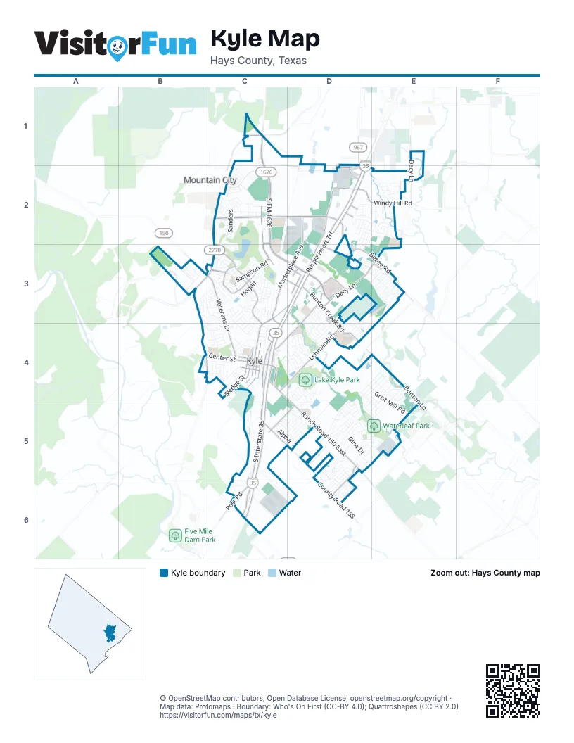
Street index of Kyle
Each street on the sheet and the grid squares it crosses.
- Purple Heart TrailD2, C3, D3, C4, C5, C6
- South FM 1626C1, C2, C3, D3
- Kyle ParkwayD3
- Yarrington RoadC6
- South Interstate 35D2, C3, D3, C4, C5, C6
- Kohlers CrossingC2, D2
- Marketplace AvenueD2, C3, D3, C4
- Ranch Road 150 EastC4, D4, D5
- Veterans DriveC3, C4
- Bebee RoadD3, E3
- North Burleson StreetC3, D3, C4
- Jack C Hays TrailC1, C2, C3
- West Center StreetC4
- North Old Highway 81C4
- Gateway BoulevardD2
- Ranch Road 150 WestB3, C3
- East Center StreetC4
- South Loop 4D2
- Dacy LaneE1, E2, D3, E3
- Kyle CrossingD2, D3
- Sampson RoadC3
- Lehman RoadC4, D4
- Cromwell DriveC2, C3
- Bunton Creek RoadD3, D4
- County Road 158C5, D5, D6
- Philomena DriveD3, C4, D4
- Fairway StreetC3
- Windy Hill RoadD2, E2
- Hartson RoadC3
- South Sledge StreetC4
- Spring Branch DriveC3, C4
- Post RoadC6
- Seton ParkwayD3
- Woodlands DriveD5, D6
- Old Post RoadC5, D5
- Bunton LaneE4
- Kyle Center DriveD3
- WitteC3
- South Main StreetC4
- South Old Stagecoach RoadC4
- North Old Stagecoach RoadB3, C3, C4
- South Old Highway 81C4
- West Lockhart StreetC4
- South Front StreetC4
- South Burleson StreetC4
- West Moore StreetC4
- North Main StreetC4
- South Nance StreetC4
- Physicians wayC3, D3
- Chula Hill DriveD2
- North Nance StreetC4
- Dorman LaneC2
- Martinez LoopC4
- Miller StreetC4
- North Front StreetC4
- ScrutchinsC3
- HartsonC3
- Sheldon DriveD3
- Republic DriveD2, D3
- Amberwood SouthD2
- Amberwood NorthD2
- Hill StreetC4
- North Sledge StreetC4
- RikardsonC2
- Amberwood LoopD2, E2
- Quail Ridge DriveC5, C6, D6
- SandersC2, C3
- Sweet Gum DriveB3, C3
- Split Rail ParkwayD5
- Grist Mill RoadD4, E4, E5
- Harvest Moon ParkwayD5
- Goldenrod StreetD4
- Apricot DriveD5, E5
- Hometown ParkwayC3, C4
- Brandi CircleD3, D4
- MatherC3
- New Bridge DriveD5, E5
- Bunton Reserve BoulevardE4, D5
- Covent DriveE3
- Downing WayD3, E3
- Chevo Pastrano Senior ParkwayC6, D6
- Cool Springs BoulevardD5, D6
- Spring Branch LoopC3
- Fountain Grove DriveD3
- HoganC3
- Harwell LoopC2, C3
- Twin Estates DriveD4, E4
- McGarityC3
- Violet LaneD4, E4
- Twin CoveD4, E4
- AtlantisC5, D5
- Evening StarD5, D6
- KirbyC2
- Treadwell LaneB3
- Waterleaf BoulevardD5, E5
- Amber Ash DriveD2, E2
- Amy DriveE4, D5, E5
- Bottle Brush DriveC3
- EverettC2
- New Country RoadD5
- Treeta TrailD4, E4, D5
- Winding Creek RoadD4, E4
- Masonwood DriveC4, D4
- NegleyC3
- Breanna LaneE4, D5
- Aztec Village DriveC5, C6
- Logistics DriveC6
- Silver Springs BendD5
- Brent BoulevardD3, D4
- Dandelion LoopE2
- DohertyC2
- CherrywoodD2, E2
- Arbor Knot DriveD4, D5
- Broken Arrow LaneD5
- Keystone LoopD3, D4
- Jack RyanC2
- SaltaC2
- MusgravC5, D5
- Whispering Hollow DriveC4, D4
- Gina DriveD5
- Steeplechase BoulevardD3, D4
- James Adkins DriveC3
- Creekside TrailD5
- North Blanco StreetC4
- Scott StreetC4
- Fall Creek DriveC3
- Opal LaneC5
- GoddardD5
- CarawayC3
- West 3rd StreetC4
- Lynn DriveD4, D5, E5
- Lake Washington DriveD3, D4
- FergusC3
- Sunlight BoulevardD2, D3
- AlphaC5, D5
- Six Creeks BoulevardB3
- Sunflower CircleE2, E3
- McNaughtonC3
- Fairfield DriveC4, D4
- East Post RoadC5
- Jim Miller DriveC3
- BarcelonaC2
- Britni LoopD4
- PowellC2
- Purple Martin AvenueE2
- Tower DriveD5
- BennerC2
- StarMeadowD5, D6
- Primrose BoulevardD4
- Voyager CoveD5
- Camelia ParkwayC3
- Silverado DriveC3, C4
- Ferrule DriveD4
- Carriage WayD4
- Brooks Ranch DriveC3
- Cibolo Creek DriveC3
- StennisD5
- MichaelisC3
- Schlemmer StreetC4
- Plum Creek MeadowsC1, C2
- West 1st StreetC4
- Amber Oak DriveD2, E2
- LangelyD5
- Westminster DriveE3
- Vista Ridge DriveD2
- Running Creek DriveD4, E4
- Dashelle RunD4
- Indian Paintbrush DriveE2
- Northern Flicker StreetE2
- Buggy Whip DriveD5
- Paddington DriveE3
- Glocken LaneB3
- Spillway DriveE3, D4, E4
- San Felipe DriveC3, C4
- Bluestem StreetD4
- Kingfisher LaneE2
- WetzelC3
- Blooming TrailD6
- Waterloo DriveE3
- Otono LoopD4, D5
- HauptC3
- Salt Springs RoadD5, D6
- Coleto Creek DriveC3
- Conestoga DriveC4
- Sheeps Trail DriveD5
- Oxford DriveE3
- Trinity DriveC3
- Four Season Farm BoulevardC4, D4
- Live Oak StreetC4
- DiscoveryC5, D5
- KeeferC2
- DreyerC2
- Abundance LaneD5, E5
- Beechwood DriveC3
- HerzogC2
- West South StreetC4
- Wren LaneE4, E5
- Buckingham DriveE3
- Buenos AiresC2
- MendozaC2
- CarmelloC2
- Bailey LoopD3
- Bloomsbury DriveE3
- West 2nd StreetC4
- Marquitos DriveE3
- City Lights DriveC3, D3
- Teychas DriveD4, E4
- BurnhamC2
- Noah StreetC4
- North StreetC4
- EnterpriseC5, D5
- Emerald Fields LaneC4, D4
- Seneca LoopE5
- Shiro DriveE5
- Old Bridge TrailD3
- Maplewood SouthD2
- Olympic Park DriveC5
- StrawnC3
- Robins Nest LaneE4, E5
- West Allen StreetC4
- Western DriveC3
- UtterbackC3
- Avenue AC2
- Beargrass DriveC4
- GreshamC2
- Nottingham LoopD3, E3
- Oriole StreetE4, E5
- Mineral Springs DriveD5
- Pecanwood SouthD2
- Connor Elkins DriveD5
- Gregg DriveC4
- SteinerC3
- Rummel DriveD5
- Chaparro DriveC4
- Dusky Thrush DriveE2
- Mathews LaneD5, E5
- Loon Lake DriveD3, D4
- Romans RoadC4
- MadridC2
- Onyx Lake DriveD3, D4
- Verna Brooks WayC3
- Estival DriveD4, D5
- JeffersC2
- Saddle Ranch DriveD5
- Zebra DriveD4
- Forrest Moon LaneD6
- Jarbridge DriveC4
- Star of Texas DriveC3, C4
- Porter StreetC4
- Texas Jack DriveC4
- Poplarwood DriveE2
- Deleon StreetC4
- Firwood NorthE2
- Keegans WayC3
- Kelly Smith LaneD2, E2
- Prairie Verbena DriveE2
- Valruth CircleD5
- Maroon LaneD2, E2, D3
- Blue Springs PassD5
- Brian LaneD4
- Grande DriveC3, C4
- North Meyer StreetC4
- HuttonC3
- Wild Buffalo DriveD4
- Ezekiel StreetC4
- Town Lake BendD4
- VaughnC2
- Pinnacle LaneC1, C2
- Bellair DriveC3, C4
- Kensington BoulevardE3
- Roland LaneC5
- ZaryaC5
- Hays StreetC4
- DornC2
- Kennicott DriveC4
- Goll StD3
- Silver Glen DriveD5, D6
- Sunnyside DriveD5
- BugbeeC2
- Ashwood NorthD2
- Thicket LaneC4, D4
- Witte RoadC3
- MarleyC2
- Scheel RoadC3
- Screech Owl LaneE2
- Birch DriveC4
- Geronimo CoveD3, D4
- RiojaC2
- Auburn StreetD2
- UnityC5
- Salado DriveC4
- DunbarD5
- Remington DriveC3, C4
- MorrellC3
- Mistletoe LaneD5, E5
- Bellie LaneE4, E5
- Jackson Blue LaneD5
- Crimson LaneD2
- Donn Brooks DriveC3
- Maplewood NorthD2
Places on the map
- 7-Eleven
- Academy Sports + Outdoors
- Advance Auto Parts
- Alexander Lake
- Amazon AUS5
- Amberwood Swimming Pool
- Applebee's
- Arby's
- Ash Pavilion
- Chapa Middle School
- CubeSmart
- Dry River District
- Goforth Plaza
- Gregg-Clarke Park
- H-E-B plus!
- Harrell Funeral Homes
- Hays CISD Performing Arts Center
- IDEA Kyle
- Kyle Crossing
- Kyle Elementary School
- Kyle Flea Market
- Kyle Marketplace
- Lake Kyle Park
- Lehman High School
- Negley Elementary School
- Plaza East
- Plum Creek Golf Course
- Plum Creek Square
- Seton Medical Center Hays
- Soil Conservation Service Site 2 Reservoir
- Soil Conservation Service Site 5 Reservoir
- Steeplechase Park
- The Park at Plum Creek
- The UPS Store
- The Village at Kyle
- Tobias Elementary School
- Wallace Middle School
- Walmart Supercenter
- Waterleaf Park
Next to Kyle
- Mountain City
© OpenStreetMap contributors, Open Database License, openstreetmap.org/copyright · Map data: Protomaps · Boundary: Who's On First (CC-BY 4.0); Quattroshapes (CC BY 2.0)















