

Texas map
Lockhart map
About 17,166 people live here (Census Bureau, 2024 estimate). The sheet's index lists 300 streets; Pickle Parkway, Farm-to-Market Road 20 and SH 130 Frontage cross the most grid squares. Also on it: Lockhart State Park, Barth Lake and Lockhart City Park.
Open the map (PDF, US Letter)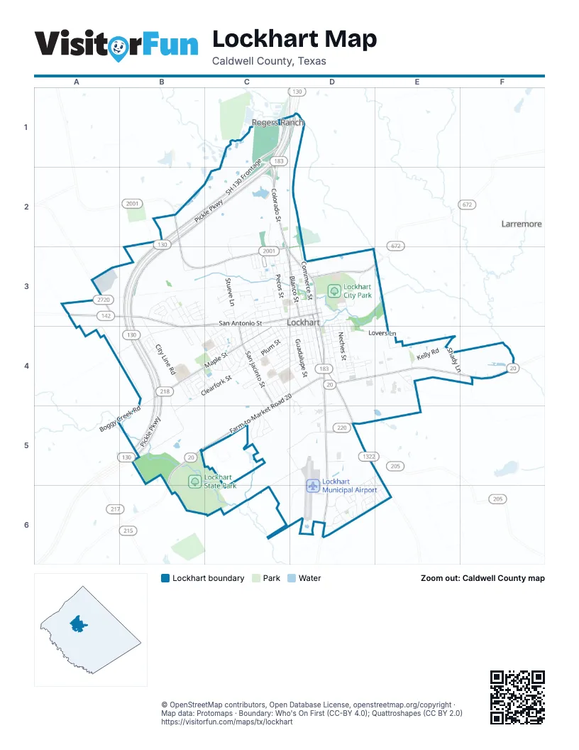
Street index of Lockhart
Each street on the sheet and the grid squares it crosses.
- Pickle ParkwayC1, D1, B2, C2, B3, B4, B5
- South Colorado StreetD3, D4, D5, D6
- North Colorado StreetC1, C2, C3, D3
- West San Antonio StreetB3, C3, D3, B4
- United States Highway 183C1, D1
- State Highway 142A3, B3
- East San Antonio StreetD3
- SH 130 FrontageC1, B2, C2, B3, B5
- Farm-to-Market Road 20C4, D4, E4, F4, B5, C5, B6
- Farm-to-Market Road 2720A3
- SH 130 Frontage RoadB3, B4, B5
- Silent Valley RoadB2, B3, C3
- Maple StreetB4, C4
- South Commerce StreetD3, D4, D5
- San Jacinto StreetC3, C4, C5
- North Blanco StreetC3, D3
- Farm-to-Market Road 672D3
- East Martin Luther King Junior Industrial BoulevardD5
- County Road 218B4
- Clearfork StreetB4, C4, B5
- South Medina StreetC3, C4, D4, D5
- City Line RoadB3, B4
- East Market StreetD3
- South Main StreetD3, D4
- Pecos StreetC2, C3
- Texas Park Road 10B5, C5, B6
- Silvercloud DriveD5, D6
- Center StreetC4, D4
- West Prairie Lea StreetD3, C4, D4
- South Guadalupe StreetD3, D4
- Lovers LaneD3, D4, E4
- Borchert LoopB3, A4, B4
- Bois D'Arc StreetC3, D3
- Stueve LaneC3
- West Live Oak StreetC4, D4
- CunninghamC5, D5, C6
- Trinity StreetD3, D4
- Plum StreetC4, D4
- South Mockingbird LaneB3, B4, C4
- Monte Vista DriveB3, C3
- South Brazos StreetD3, D4
- North Commerce StreetD3
- South Church StreetD3, D4
- Windsor BoulevardB3
- Cibilo StreetC3, C4, D4
- South Blanco StreetD3, D4
- Summerside AvenueD6
- Neches StreetD3, D4
- Boggy Creek RoadB4, A5, B5
- West Martin Luther King Junior Industrial BoulevardC5, D5
- Kelly RoadE4
- Halfmoon DriveD6, E6
- Leona StreetC3, C4
- Navidad StreetC3, C4
- Thunderstorm AvenueD6, E6
- Frio StreetC3, C4, D4
- Carver StreetD3
- North Medina StreetC3
- Shady LaneE4, F4
- Colton LaneC4
- Fir StreetC3
- Windridge DriveB3, C3
- West Market StreetC3, D3
- Wirecrested DriveB3
- East Live Oak StreetD3, D4
- Woodlawn AvenueC3
- Peach StreetC3
- Lantana AvenueB4, C4
- South Rio Grande StreetC3, C4
- City Park RoadD3
- Twin Island DriveC5
- Rosewood StreetD4
- North Mockingbird LaneB3
- Chihuahua StreetD4
- Old McMahan TrailE4
- Walter Ellison DriveC4
- Hackberry StreetC4, D4
- Saint Thomas StreetC4
- Windrow LaneD6
- Dewitt StreetA3
- Patton RoadC4, C5
- Wichita StreetC3
- Horseshoe RoadB3
- Lion Country DriveC4, D4
- 5th StreetD4
- Hondo StreetC3
- Meadow LaneC5
- London WayC4
- Jet Stream DriveE5, D6, E6
- 4th StreetD4
- Arena RoadB5, C5
- Merritt DriveC4, D4
- Paintbrush DriveB4, C4
- Lincoln LaneB4, B5
- Reed DriveE4
- North Richland DriveB3, B4
- Foxglove DriveB4
- Indian Blanket StreetB4, C4
- Vogel DriveC4, D4
- Parkview DriveC5
- Bufkin LaneD5
- East Walnut StreetD3
- County Road 108A4
- Red River StreetC3, D3
- Connally CircleC4
- West China StreetC3, D3
- Emilie WayB4
- Dove LaneC4
- North Church StreetD3
- Sunrise TerraceC5
- Travis StreetC4
- West Pecan StreetC3, D3
- Dandelion StreetB4
- Cahill StreetA3
- Spruce StreetC4
- Magnolia StreetC3, C4
- Christopher's CoveC4
- Lakeview DriveC4
- Aransas StreetD4
- Addison PlaceC4
- Sipes RoadE4
- Teller DriveB4
- Richland DriveB4
- Hickory StreetD4
- Nixon StreetC4, D4
- Pancho StreetD4
- Tank StreetC3
- Century Oak DriveE4
- Pendergrass StreetC4
- Chisholm TrailD5
- Ruddy StreetD4
- Sabine StreetD3, D4
- San Saba StreetD3, D4
- Crane LaneC1
- Courtney BoulevardB4
- White Oak StreetD4
- Ross CircleD4
- Torres StreetD4
- Henbit LaneB4
- Red Sky DriveD6, E6
- Sunset DriveD5
- Meadow Lake DriveC2, C3
- Sundown BoulevardC5
- Clark LoopA3
- East Mlk Jr Industrial BoulevardE4
- Pearl StreetD4
- Weld DriveB4
- Dogwood StreetB4
- Blake's CoveC4
- Blue Sky LaneD6
- Crockett StreetC4
- Fannin StreetC4
- Pitkin DriveB4
- West Bee StreetD4
- Concho StreetC4
- West Olive StreetC3, D3
- Sunshadow LaneD6
- Summit DriveB4
- West Cedar StreetC3, D3
- Bowie StreetC4
- Persimmon StreetD4
- Tonkawa StreetC3
- Campbell StreetC4
- Clear Sky DriveE6
- Kiowa TrailC3
- Alamo StreetC4
- Shenandoah TrailB3
- Shoshoni TrailC3
- Ash StreetC3, D3
- Wilson StreetC3
- Willow StreetC3, D3
- Prickly Pear StreetB4, C4
- Abbey LaneC4
- Wedgewood TrailB3
- North Main StreetD3
- Pin Oak StreetD4
- Bramhall StreetC4
- Monument StreetD3, D4
- Caribbean StreetC4
- Redchinned DriveB3
- East Prairie Lea StreetD3
- Green StreetC3
- Pedernales StreetD3, D4
- Nueces StreetC3
- Sea Breeze DriveD5, D6
- Elm StreetC3
- North Rio Grande StreetC3
- Hunter's RoadD4, D5
- Orange StreetC3, C4
- Blizzard DriveD6
- Greenwood DriveB3
- Meadow Park LaneD4
- Sandhill DriveD6
- Fullmoon DriveD6, E6
- Gulf Stream DriveD6
- Dust Devil DriveD6
- Standstorm StreetD5, E5, E6
- Laredo StreetD3
- Reynolds StreetD3
- Applewood DriveB3
- Cemetery StreetD3
- Darwin PlaceC4
- Braden StreetC3
- Mimosa DriveC3
- Pear StreetC3
- Redbud TrailC3
- Comal StreetC3
- Cyclone DriveE6
- Tornado AlleyE6
- Johnson StreetC3
- Waterspout DriveD5, D6, E6
- Artic Air DriveE5
- Kate StreetD3
- Apple StreetD3
- Scheh StreetD3
- Golden Age HomeD4, D5
- Farmer StreetD3
- Guadalima StreetC3
- McMillen BoulevardC4, C5
- West Walnut StreetD3
- Belmont PlaceC4
- Cedarwood DriveB3
- Lemonmint StreetB4
- Sunray DriveD6
- Aylor WayC4
- Mulberry StreetD3
- North Guadalupe StreetD3
- Garcia StreetD4
- Hummingbird LaneC3, C4
- Legion StreetC2, C3
- Cottonwood StreetD4
- 1st StreetD4
- Aspen StreetC3
- East Pecan StreetD3
- Veteran StreetC2, C3
- Gunnison CoveB3
- Sunflower StreetB4
- La Feliciana DriveC4
- Luann LaneD4
- East Olive StreetD3
- Hardwood DriveB3
- Trade Winds DriveD5, D6
- Spinnaker StreetD4
- Drizzle DriveD6
- Shadow WalkC5
- Kennedy RoadD3
- Langdon GroveC4
- Mesquite StreetC3
- Cumulus CourtE6
- Pine StreetC3, D3
- Sycamore StreetD3
- 3rd StreetD4
- Prescott PlaceC4
- Thorntail DriveB3
- Wassa StreetC3
- Comanche TrailC3
- Atascosa StreetC4
- Larremore RoadD3
- Sierra Vista CoveF4
- Airport RoadD5
- Lancebill DriveB3
- Maplewood DriveB3
- East China StreetD3
- Night Sky CoveD6
- Highcloud DriveD6
- Monterrey StreetD4
- Hausman DriveC3
- Ward StreetC3
- East Navarro StreetD3
- Yucca DriveB4
- Sherwood StreetD4
- Reyes StreetD4
- Havelock WayC4
- Llano StreetC3
- Sprinkle DriveD6
- Juarez StreetD4
- North Brazos StreetD3
- Monsoon DriveD6
- Mora StreetD4
- 2nd StreetD4
- Little River StreetC3
- Proctor StreetC3
- Dobins CourtC4
- Oak KnollE4
- Loma StreetC3
- Hardeman StreetD4
- Quail CoveC4
- Redwood StreetC3
- Schroeder StreetC3
- Brown StreetC3
- Highland StreetC3
- Flores StreetD3
- East Cedar StreetD3
- Locust StreetD3
- Chaparral StreetD4
- East Bee StreetD4
- Poplar StreetD4
- Ironwood DriveB3
- Alex StreetC3
- Rio Vista CoveF4
Places on the map
- Advance Auto Parts
- America's Best Value Inn Lockhart
- American Legion Post 41
- Assisted Living Lockhart
- Austin Telco Federal Credit Union
- AutoZone
- Barth Lake
- Best Western Lockhart Hotel & Suites
- Bluebonnet Elementary School
- Caldwell County Courthouse
- Caldwell County Sheriff
- Carver School
- Cash America Pawn
- Cemeterio Navarro Historico
- CenTex Storage Lockhart
- Chisholm Trail Bar-B-Que
- Chisholm Trail Veterinary Clinic
- Chisolm Trail Nursing & Rehab Center
- Clear Fork Elementary School
- CubeSmart
- Dollar Tree
- Faith Chapel
- Family Dollar
- First Apostolic Church
- First Lockhart Baptist Church
- First United Methodist Church
- Floors Plus
- Fresenius Kidney Care
- Golden Age Home
- Grace Evangelical Lutheran Church
- Hanson Equipment
- Lockhart City Park
- Lockhart High School
- Lockhart Junior High School
- Lockhart Municipal Airport
- Lockhart Self Storage
- Lockhart State Park
- Maple Street Park
- Smith Supply
Next to Lockhart
- Larremore
- Rogers Ranch
© OpenStreetMap contributors, Open Database License, openstreetmap.org/copyright · Map data: Protomaps · Boundary: Who's On First (CC-BY 4.0); Quattroshapes (CC BY 2.0)















