

Texas map
McKinney map
About 227,526 people live here (Census Bureau, 2024 estimate). The sheet's index lists 133 streets; Ridge Road, North Hardin Boulevard and Central Expressway cross the most grid squares. Things to do inside the boundary: McKinney Visitor Center.
Open the map (PDF, US Letter)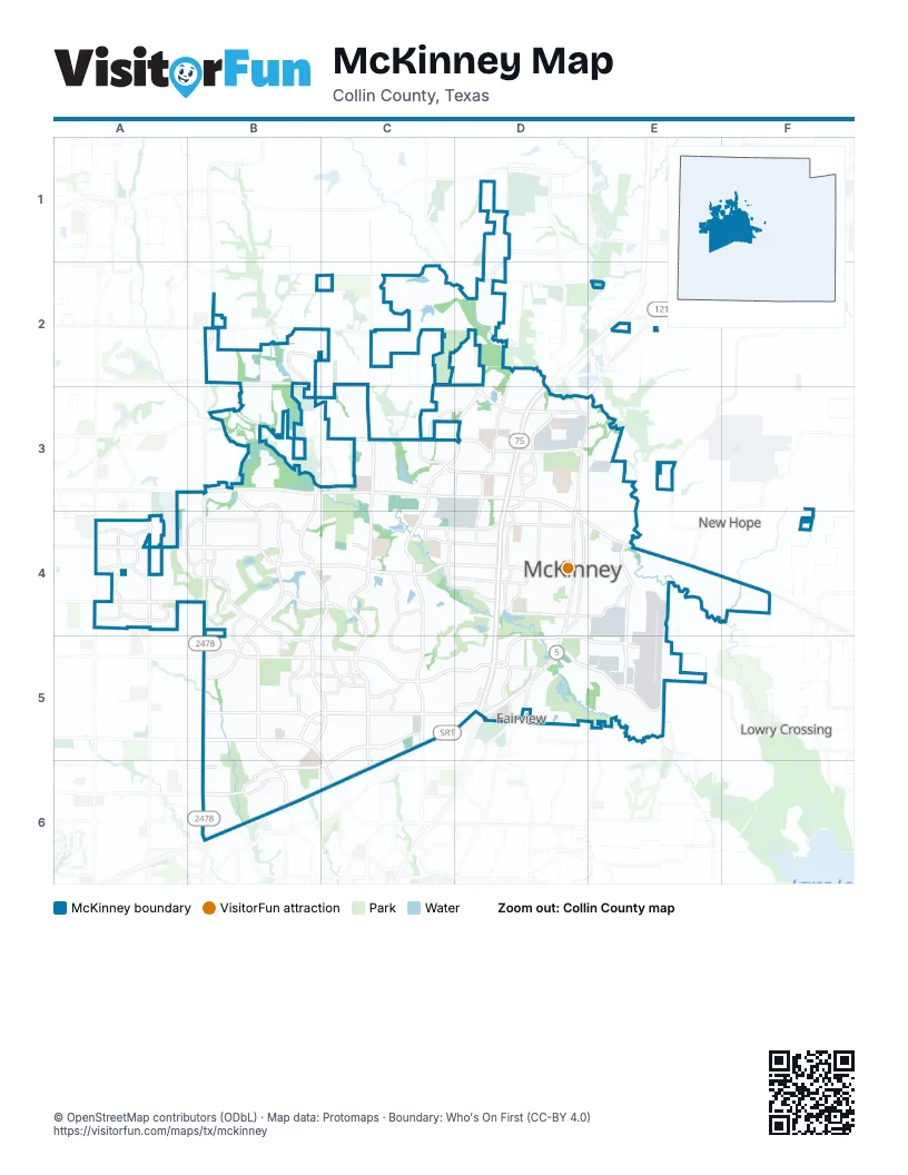
Street index of McKinney
Each street on the sheet and the grid squares it crosses.
- Hardin BoulevardD1, D2
- Olympic CrossingD1
- County Road 123B2
- Gladewater AvenueB2
- Limestone AvenueB2
- North Custer RoadB2, B3, B4
- Ridge RoadB2, B3, B4, C4, B5, C5
- Bloomdale RoadC2, D2, D3
- Community AvenueD2, D3, D4
- North Hardin BoulevardD2, C3, D3, C4
- Weston RoadD2, D3
- Central ExpresswayE2, D3, D4, D5
- County Road 124B3
- Grassmere LaneB3
- La Cima DriveB3, B4
- North Ridge RoadB3, B4
- Stonebridge DriveB3, B4, B5
- West University DriveB3, C3, D3, D4
- Auburn Hills ParkwayC3
- Erwin Farms BoulevardC3
- Holley Ridge WayC3, D3
- Lake Forest DriveC3, C5
- North Lake Forest DriveC3, C4
- Taft LaneC3
- Taylor-Burk DriveC3, D3
- Wilmeth RoadC3, D3
- Bloomdale DriveD3
- Bray Central DriveD3
- Central CircleD3
- Heritage BoulevardD3
- Laud Howell ParkwayD3, E3
- North Central ExpresswayD3, D4
- North McDonald StreetD3, E3, D4
- North Redbud BoulevardD3, D4
- North Tennessee StreetD3, D4
- North Waddill StreetD3, D4
- Redbud BoulevardD3
- Skyline DriveD3
- Taylor Burk DriveD3
- Bluestem DriveA4
- Eden DriveA4
- Hidden Haven DriveA4
- Independence ParkwayA4
- Jacksboro LaneA4
- JFK BoulevardA4
- Lukenbach DriveA4
- Rambling RoadA4
- Reagan DriveA4
- Reagenea DriveA4
- South Virginia Hills DriveA4, B4
- Virginia Hills DriveA4, B4
- Virginia ParkwayA4, B4, C4, D4
- Westridge BoulevardA4, B4
- Bristol DriveB4
- Coronado DriveB4
- Cotton Ridge North RoadB4
- Cotton Ridge South RoadB4
- Custer RoadB4, B5, B6
- Falcon View DriveB4
- Glen Oaks DriveB4, C4
- Habersham WayB4
- Hillsdale DriveB4, B5
- Peregrine DriveB4
- Plainfield DriveB4, B5
- Saint Gabriel WayB4
- South Custer RoadB4, B5, B6
- Bois D'Arc RoadC4, D4
- Crowe LaneC4
- Jordan RoadC4
- Mallard Lakes DriveC4
- North Brook DriveC4, D4
- Raincrest DriveC4
- Rockhill RoadC4, D4
- South Hardin BoulevardC4, C5
- South Lake Forest DriveC4, C5, C6
- West White AvenueC4, D4
- White AvenueC4, D4
- Winding Brook DriveC4, C5
- Winding TrailC4
- East Louisiana StreetD4
- East University DriveD4, E4
- East Virginia StreetD4
- Elm StreetD4, E4
- North Graves StreetD4
- North Kentucky StreetD4
- South Central ExpresswayD4, D5
- South Graves StreetD4
- South Kentucky StreetD4
- South McDonald StreetD4, D5
- South Tennessee StreetD4
- West Louisiana StreetD4
- West Virginia StreetD4
- West White StreetD4
- Wilson Creek BoulevardD4
- Wilson Creek ParkwayD4
- North Airport DriveE4
- South Airport DriveE4, E5
- Alma RoadB5
- Berkshire RoadB5
- Brookstone DriveB5
- Eldorado ParkwayB5, C5, D5
- Hudson CrossingB5
- Main StreetB5
- McKinney Ranch ParkwayB5, C5, D5
- North Alma RoadB5, B6
- Pine Ridge BoulevardB5, C5
- Silverado TrailB5, C5
- Stacy RoadB5, C5, C6
- Ash LaneC5
- Avery LaneC5
- Cedar Elm DriveC5
- Collin McKinney ParkwayC5, D5, B6, C6
- Columbus DriveC5
- Highlands DriveC5
- Maverick TrailC5
- Sam Rayburn TollwayC5, D5, B6, C6
- Sidney LaneC5
- State Highway 121C5, D5, B6, C6
- Woodson DriveC5
- Harry McKillop BoulevardD5, E5
- Industrial BoulevardD5, E5
- Medical Center DriveD5
- Spur 399D5
- Stewart RoadD5
- Test DriveD5
- County Road 317E5
- Craig Ranch ParkwayB6
- Gartner RoadB6
- Paradise DriveB6
- Ridge Creek ParkwayB6
- Rolater RoadB6
- Van Tuyl ParkwayB6
- West Exchange ParkwayB6
Things to do on the McKinney map
Places on the map
- 380 McKinney C&D Landfill
- 380 Towne Crossing
- A. Hardy Eubanks Jr. Park
- Adriatica Village
- Al Ruschhaupt Soccer Complex
- Anthology of Stonebridge Ranch
- Ash Woods Park
- Ashton Oaks Apartments
- Aura Bella
- Avendale at Painted Tree
- Avenues at Craig Ranch
- Barcellona
- Bent Creek Apartments
- Bexley Lake Forest
- Blue Mountain Equipment
- Bonnie Wenk
- Bonnie Wenk Park
- Bramblewood Mobile Home Park
- Brandon Tomes Subaru
- Brookhaven Church
- C T Eddins Elementary School
- Cannon Beach
- Carey Cox Memorial Park
- City Park Land (open space)
- Clublake Trail
- Collin County Jail
- Comstock Elementary
- Cottonwood Creek Channel
- Craig Crossing
- Craig Ranch Linear Park
- Craig Ranch North
- Creek Hollow
- Creekside at Craigs Ranch
- Creekview Estates
- Crosspoint Church
- Crossroads Park and Trail
- CubeSmart Self Storage
- Cypress Apartments
- Days Inn by Wyndham McKinney
- Discovery at Craig Ranch
Next to McKinney
- Fairview
- Lowry Crossing
- Melissa
- New Hope
© OpenStreetMap contributors (ODbL) · Map data: Protomaps · Boundary: Who's On First (CC-BY 4.0)