

Texas map
Midland County map
About 183,587 people live here (Census Bureau, 2024 estimate). The sheet's index lists 300 streets; East Highway 80, Farm-to-Market Road 1787 and Farm-to-Market Road 1788 cross the most grid squares. Things to do inside the boundary: West Texas Symphony.
Open the map (PDF, US Letter)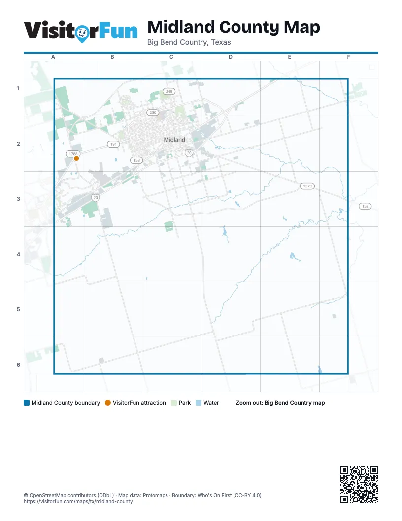
Maps inside Midland County
1 map inside, from the street map of Midland County down.
Street index of Midland County
Each street on the sheet and the grid squares it crosses.
- Sergeant Michael Naylor Memorial HighwayA2, B2, A3
- Chris Kyle Memorial HighwayA3
- East Highway 80D1, E1, C2, D2, A3
- West Highway 80B2, A3, B3
- East Loop 250 NorthC1, D1, D2
- South State Highway 349C2, C3, C4, D4
- West Industrial AvenueB2, C2, B3
- Nadine and Tom Craddick HighwayB1, A2, B2
- West Loop 250 NorthB1, C1, B2, C2
- TX 349D4, D5, D6
- West Wall StreetB2, C2
- West State Highway 158A1, A2, B2
- North FM 1788A1, A2
- North Big Spring StreetC1, C2
- North Midland DriveB1, B2, C2
- Andrews HighwayB2, C2
- South Loop 250 WestB2, B3
- South FM 1788A2, A3, B3
- Garden City HighwayC2, D2
- West Front StreetC2
- Rankin HighwayC2
- South Fairgrounds RoadC2
- South Garfield StreetC2
- East State Highway 158D2
- East Front StreetC2
- West Florida AvenueC2
- South Big Spring StreetC2
- East Florida AvenueC2
- State Highway 349C1
- Williams StreetC2
- I-20E (Bus)C2
- West Interstate 20B2, C2, A3, B3
- Farm-to-Market Road 1787C5, D5, A6, B6, C6
- Farm-to-Market Road 1788B3, B4, B5, B6, C6
- State Highway 191A2, B2, A3
- Nathan Heidelberg Memorial HighwayE1, F1, D2, E2
- East Interstate 20D1, C2, D2, A3
- South Midkiff RoadC2, C3, C4
- Dora Roberts RoadA4, B4, A5, B5
- Farm-to-Market Road 3095E5, E6
- West Wadley AvenueB2, C2
- Holiday Hill RoadB1, B2
- FM 715C2, D3
- Farm-to-Market Road 1379D5, D6
- West Illinois AvenueB2, C2
- Mockingbird LaneB1, C1
- North Loop 250 WestB2
- North Midkiff RoadB1, C1, C2
- North A StreetC1, C2
- North Fairgrounds RoadC1, C2
- North Lamesa RoadC1, C2
- South County Road 1130D2, D3
- Briarwood AvenueB2
- North County Road 1130D1, D2
- North Garfield StreetC1, C2
- East Yukon Road (SCR 1310)A3, B3
- West Michigan AvenueC2
- West Scharbauer DriveC2
- Cotton Flat RoadC2, C3
- East Scharbauer DriveC2
- West Golf Course RoadC2
- Greentree BoulevardB1
- Thomason DriveB2, C2
- Faudree RoadA3
- South Midland DriveC2
- South Lamesa RoadC2
- FM 307C2, D2
- West Texas AvenueC2
- East Wadley AvenueC1, C2
- Ranch to Market Road 1492B6
- East Illinois AvenueC2
- Cloverdale RoadC2
- East Texas AvenueC2
- West County Road 40A2
- Ranch to Market Road 1357F5
- Yukon RoadA3
- East Yukon RoadA3
- Midkiff RoadB1, C2
- North Kent StreetC2
- Loop 250C1
- West Loop 250 North Frontage RoadC1
- Garfield StC2
- Farm Road 1369B2
- West Interstate 20 Frontage RoadC2
- East County Road 120C2, D2, E2, F2
- WCR 173C3, D3, E3
- East County Road 140F2, C3, D3
- South County Road 1140D2, D3
- East County Road 130C2, D2, C3
- South County Road 1232B3, C3
- West County Road 140B3, C3
- West County Road 130B3, C3
- South County Road 1050E1, E2
- Tradewinds BoulevardB2
- West Cuthbert AvenueB2, C2
- West County Road 60A2, B2
- Neely AvenueB2, C2
- West County Road 122A3, B3
- Storey AvenueB2, C2
- Princeton AvenueB2, C2
- North County Road 1150C1, D1, D2
- West Louisiana AvenueC2
- Sinclair AvenueA2, B2, C2
- North County Road 1140D1, D2
- Elkins RoadD1, D2
- Lanham StreetC1, C2
- Godfrey StreetB2, C2
- Ward StreetC1, C2
- Deauville BoulevardB2
- Avalon DriveB1, B2
- Occidental ParkwayC1
- Todd RoadC1, C2
- South County Road 1180C2, C3
- Shell AvenueB2, C2
- East Golf Course RoadC2
- North Main StreetC2
- State Highway 191 EastA3
- Bluebird LaneB1, C1
- Anetta DriveB2, C2
- West County Road 100A3
- West Shandon AvenueC2
- McDonald StreetB2, C2
- North Tyler StreetC2
- Crowley BoulevardB2
- Dorado DriveA3
- South Cotton Flat RoadC3
- Wadley AveB2
- West Francis AvenueC2
- West County Road 54A2, B2
- West Kentucky AvenueC2
- East Taylor AvenueC2
- Whitney DriveC2
- Haynes AvenueB2, C2
- North D StreetC2
- Douglas AvenueB2, C2
- North L StreetC2
- Oriole DriveB1, B2
- Mission DriveA3
- North Pecos StreetC2
- East New York AvenueC2
- Mission BoulevardA3
- East Cuthbert AvenueC2
- North County Road 1135D1
- West Humble AvenueC2
- West County Road 120C2, B3, C3
- La Force BoulevardB3
- Heritage BoulevardB2
- East Pecan AvenueC2
- North Marienfeld StreetC2
- South Terrell StreetC2
- East Indiana AvenueC2
- Rustic TrailB1
- North County Road 1050E1
- Tarleton StreetC2
- North County Road 1275A2, B2
- Solomon LaneC1
- Boyd AvenueC2
- Loop 40B3
- Bankhead HighwayC2, A3
- Fannin AvenueB2, C2
- Castleford RoadC1
- Whitman DriveC1
- Beal ParkwayB2
- North I StreetC2
- East Oak AvenueC2
- South Main StreetC2
- Mark LaneB2
- South Eisenhower DriveB2, C2
- West Indiana AvenueC2
- Maxwell DriveC2
- Smith RoadC1, C2
- Riverside DriveB1
- Whittle WayB2
- Bedford AvenueB2, C2
- Idlewilde DriveB2
- Caldera BoulevardB1, C1
- Homestead BoulevardB2
- North Terrell StreetC2
- College AvenueC2
- Monty DriveB2, C2
- North Tilden StreetC2
- Stonebridge DriveC1
- East Wall StreetC2
- Sherwood DriveB1
- Desta DriveC1, C2
- West County Road 117C2, B3
- Doctor Emmitt Headlee StreetA3
- West Carter AvenueC2
- Tanforan AvenueB1
- Golden Gate DriveB1, B2
- Alpine StreetC2
- North Lincoln StreetC2
- Leisure DriveB2
- South Marienfeld StreetC2
- East Nobles AvenueC2
- Ric DriveB2
- Marie DriveC1, C2
- Teakwood TraceB1
- East Industrial AvenueC2
- Island DriveB1
- Northrup DriveC2
- South Bentwood DriveB2
- San Antonio StreetA3
- Preston DriveB2
- East Dormard AvenueC2
- Tremont AvenueB2
- Trobaugh BoulevardB2
- Saint Andrews DriveB2
- Legacy RoadA3
- Edgewood DriveB2, C2
- South Johnston StreetC2
- Santa Isabella StreetA3
- Dentcrest DriveB2
- Hereford BoulevardB2
- Spraberry DriveC2
- Greenbriar DriveB2
- Graceland DriveB2, C2
- Polo ParkwayC1
- East Gist AvenueC2
- Wood DriveB1
- Butternut LaneC2
- Country Road 1250B3
- West Taylor AvenueC2
- West County Road 30A1
- Wydewood DriveB2
- Chukar LaneC2
- Woodcrest DriveB2
- Lancashire RoadC1
- Meadow DriveC2
- North Benton StreetC2
- Devonian DriveC2
- West Dormard AvenueC2
- Crenshaw DriveC1
- South County Road 1255B3
- North Bentwood DriveB2
- West Nobles AvenueC2
- Antelope TrailB3
- Sunshine ParkwayB2
- Crestgate AvenueB1
- Dumfries RoadB2
- West Gist AvenueC2
- English DriveC2
- Canyon DriveC2
- Grassland BoulevardB2
- Norwood StreetB2
- Widener StripB1
- Northfield DriveB2, C2
- Versailles DriveB2, C2
- Valwood DriveB1
- BraniffB2, B3
- Western DriveC2
- San Andres DriveC2
- Alysheba LaneC1
- Veterans Airpark LaneC1
- League DriveB2
- P Bar Ranch RoadA3
- Champions DriveB2
- Faulkner DriveC1
- Skyline DriveC2
- Lehigh DriveB2
- Comanche DriveB2, C2
- East Louisiana AvenueC2
- Callaway DriveB2
- Highland BoulevardB2
- East Michigan AvenueC2
- Driftwood DriveB1
- Chapel Hill DriveC1
- Sequoia DriveB1
- Sloan Field BoulevardB3
- Trinity DriveB2, C2
- Melville DriveC1
- Edwards StreetC1
- East 56th StreetA3
- West New York AvenueC2
- Bunker Hill RoadB2
- Keswick RoadC1
- Bayberry ParkwayC1
- Bent Tree TrailB1
- Palmer DriveC1
- Gateway StreetB1
- East Goldenrod DriveA1
- Parks Bell BoulevardA3
- Nicklaus StreetC1
- Corporate DriveC1
- Rockwood DriveB1
- Goliad DriveB2
- Spring Meadow LaneC1
- Liddon AvenueC2
- Meadowpark DriveC1
- Mc Donald DriveC2
- Eastridge RoadA3
- Crestway LaneB1, B2
- Copus StreetC2
- Castlegate LaneA3
- Golf Course RoadD2
- Dr. J. Naidu StreetA3
- Crestfield StreetB1, B2
- South A StreetC2
- Fasken DriveC2
- San GabrielA3
Things to do on the Midland County map
Places on the map
- Advenir at The Meadows
- Airline Mobile Home Park
- Alldrege Gardens
- Audrey Gill Sports Complex
- Beal Park
- Brownstone Square Office Park
- Bush Tennis Center
- C.J. Kelly Park
- CAF Ramp
- City of Midland Landfill
- Consavvy Lake
- County Road 60 RV Park
- Courtyard at Midland Park
- Dorado Center
- Downtown Midland Management District
- Drainage reservoir
- Eagles Nest Gliderport
- Entrada Business Park
- Executive Ramp
- Fairview Cemetery
- Fasken Vineyard Complex
- Green Tree Country Club
- Green Tree Pond
- Greenwood High School
- Greenwood Terrace
- Hogan Park
- Holly's RV Park
- Horseshoe
- Jones Brothers
- Lake Welch
- Lee Senior High School
- Legacy Park
- Midland
- Nueva Vista Golf Club
- Pecks Lake
- Rock The Desert Festival Field
- Salt Lake
- Scharbauer Sports Complex
- Stephenson Lake
- The Courses at Hogan Park
© OpenStreetMap contributors, Open Database License, openstreetmap.org/copyright · Map data: Protomaps · Boundary: Who's On First (CC-BY 4.0); Quattroshapes (CC BY 2.0)















