

Texas map
Odessa map
About 119,748 people live here (Census Bureau, 2024 estimate). The sheet's index lists 300 streets; East Interstate 20, Northeast Loop 338 and State Highway 191 East cross the most grid squares. Things to do inside the boundary: Discover Odessa and Music City Mall.
Open the map (PDF, US Letter)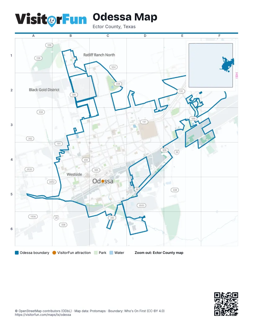
Street index of Odessa
Each street on the sheet and the grid squares it crosses.
- Chris Kyle Memorial HighwayE2, D3, E3
- Sergeant Michael Naylor Memorial HighwayE1, E2
- George E. "Buddy" West Memorial OverpassE4
- East Highway 80E3, D4, E4
- State Highway 191 EastE1, E2, D3, E3
- North Grandview AvenueC2, C3, C4, D4
- East University BoulevardD3, C4, D4
- Andrews HighwayB2, B3, B4, C4
- South Grant AvenueC5, C6
- Ray C. Stoker, Jr. Memorial HighwayD2, D3, D4
- Northeast Loop 338C1, C2, D2, D3, D4
- John Ben Shepperd Parkway BoulevardD2, D3, D4
- East 42nd StreetB3, C3, D3
- East 2nd StreetC4, D4, C5
- Kermit HighwayB4, C4
- Southeast Loop 338D4, E4
- West 2nd StreetB5, C5
- West Highway 80E3, F3
- West University BoulevardB4, C4
- North Grant AvenueC4, C5
- South Grandview AvenueD4, D5
- Bainbridge DriveD3, D4
- South John Ben Sheppard Parkway BoulevardD4
- West 42nd StreetB3
- Northwest Loop 338B5
- West UniversityB4
- East Interstate 20E3, F3, D4, E4, C5, D5
- North Dixie BoulevardB3, C3, C4
- West Interstate 20F3, C5, B6, C6
- Faudree RoadD2, E2, E3, F3
- Maple AvenueC3, D3, C4
- North County Road WestB3, B4, B5
- East 52nd StreetB3, C3, D3
- Tanglewood LaneC3, D3, D4
- East 8th StreetC4, D4
- East Yukon RoadE1, B2, C2
- West 8th StreetC4, B5, C5
- East 87th StreetB1, C1, B2
- Golder AvenueB4, C4, C5
- East Pool RoadC5, D5
- South Dixie BoulevardC4, C5
- East Martin Luther King Jr. StreetD4, C5, D5
- South County Road WestB5, B6
- North Golder AvenueB3, B4
- West 16th StreetB4, C4, B5
- South Crane AvenueC5
- Harless AvenueB5
- Crane AvenueC5, C6
- West Pool RoadC5
- East Yukon Road (SCR 1310)F2
- South John Ben Sheppard BoulevardD4
- Yukon RoadE1
- West Yukon RoadB2
- North Crane AvenueC5
- West 87th StreetB2
- 87th StreetC1
- Dawn AvenueC1, C2, C3, C4
- West 10th StreetC4, B5, C5
- North Muskingum AvenueC3, C4, C5
- East 17th StreetC4, D4
- West Murphy StreetB5, C5
- West 5th StreetB5, C5
- West 3rd StreetB5, C5
- Eastridge RoadD3, E3
- West County Road 122F2, E3, F3
- East 10th StreetC4, D4
- Billy Hext RoadE2, E3
- East 56th StreetE2, B3, C3
- Oakwood DriveD3, C4, D4
- Redbud AvenueC3, C4
- West 22nd StreetB4
- East 14th StreetC4
- East 7th StreetC4, D4
- Whitaker AvenueB4, B5, C5
- Mission DriveE2, F2, E3, F3
- Mission BoulevardE2, F2
- East 31st StreetC3, B4, C4
- West 7th StreetC4, B5, C5
- West 14th StreetB4, C4, B5
- 56th StreetD2, E2, C3
- East Pearl StreetC4, D4, C5
- East 5th StreetC4, C5
- Dorado DriveE2, F2
- West Clements StreetB5, C5
- Rocky Lane RoadD3, E3
- Rainbow DriveB1
- Lyndale DriveC3
- West 23rd StreetB4, C4
- East 23rd StreetC4
- Pagewood AvenueD3, D4
- East 38th StreetB3, C3
- Nabors LaneC3, C4
- Tres Hermanas BoulevardE2, E3
- Arroyo RoadE2, D3, E3
- Doctor Emmitt Headlee StreetE2
- West 17th StreetB4, C4, B5
- South Muskingum AvenueC5
- Parks Legado RoadE2, E3
- San Antonio StreetE2
- Industrial AvenueD4, D5
- Newell RoadE3
- Grandview AvenueC2
- Santa Isabella StreetE2, F2
- Laredo DriveC5, D5
- East 3rd StreetC4, C5
- 52nd StreetD2, D3
- Conover AvenueB4
- 91st StreetB1
- Stoney Ridge RoadE3
- Castlegate LaneE2
- East Clements StreetC5
- West 61st StreetB3
- State Highway 191E1
- East 100th StreetB1
- L AvenueA5
- Evans BoulevardB1
- South Meadow AvenueD4
- Governor Preston Smith RoadD3
- Country Club RoadE3, E4
- Dr. J. Naidu StreetE2
- Bankhead HighwayE3
- East 91st StreetB1
- San GabrielF3
- East Murphy StreetD5
- Sterling Park RoadC6
- Standard AvenueC5
- North Tom Green AvenueB3, C3, C4, C5
- US 385 Service Road NorthB1, B2
- East 21st StreetC4, D4
- East 11th StreetC4, D4
- Bonham AvenueC3, C4
- Adams AvenueC3, C4, C5
- North Hancock AvenueC3, C4, C5
- North Jackson AvenueB3, C4, C5
- South County Road 1305F2
- West 6th StreetB5, C5
- North Washington AvenueB4, C4, C5
- West 4th StreetB5, C5
- East Everglade AvenueC3, D3
- Center AvenueC4
- North Texas AvenueB3, B4, C4, C5
- McKnight DriveB3, C3, C4
- East 6th StreetC4, D4, C5
- West 15th StreetB4, C4, B5
- West 9th StreetC4, B5
- North Alleghaney AvenueB4, C4, C5
- East 51st StreetB3, C3, D3
- Brentwood DriveC3, C4
- Groening StreetE3, F3
- East 46th StreetB3, C3
- West 20th StreetB4, C4
- West 13th StreetB4, C4, B5
- Santa Rosa AvenueB4, B5
- North Sam Houston AvenueB4, C4, C5
- East 13th StreetC4
- East 37th StreetB3, C3, D3, B4
- West 18th StreetB4, C4
- Douglas DriveB3, C3
- East 25th StreetC4, D4
- Lamar AvenueB1, B2
- Englewood LaneC3, D3, D4
- Winchester AvenueC3
- East 12th StreetC4
- East 43rd StreetB3, C3
- West 19th StreetB4, C4
- North Everglade AvenueC3
- Walnut AvenueC3, C4
- Eisenhower RoadC3, C4
- East 49th StreetB3, C3
- Santa Monica AvenueB4
- North Lee AvenueC4, C5
- Beechwood StreetC4, D4
- Cambridge StreetC4, D4
- Boulder AvenueC3, D3, C4
- West Ada StreetB5, C5
- West 24th StreetB4
- South Jackson AvenueC5
- West 12th StreetB4, C4, B5
- Mac Arthur AvenueB5
- Graham AvenueB4, B5, C5
- Locust AvenueC3
- Holiday DriveB1, B2
- Cumberland RoadC4, D4
- South Texas AvenueC5
- South Sam Houston AvenueC5
- Drury LaneB5, C5
- Fitch AvenueC4, C5, D5
- Edison AvenueB4, B5
- Custer AvenueD3, D4
- Clifford StreetB5, C5
- East 4th StreetC4, C5
- Idlewood LaneD3, D4
- Royalty AvenueC4
- Lindberg StreetB5, C5
- San Fernando DriveB4, B5
- North Kelley AvenueB4, B5
- Crescent DriveC4
- West Monahans StreetC5
- North Lincoln AvenueB4, C4, C5
- Dotsy AvenueB4, C5
- Park BoulevardB5
- UTPB Park RoadD3
- Penbrook StreetC3, D3
- Myrtle StreetC4, D4, C5
- East 57th StreetB3, C3
- Dublin AvenueB1, B2
- East 53rd StreetC3, D3
- Coronado AvenueB4, B5
- West 11th StreetB4, C4, B5
- West 25th StreetB4
- Patton DriveC4
- East 35th StreetC3, C4
- East 18th StreetC4
- East 36th StreetC3, C4
- West UTPB CircleD3
- Boise DriveC3
- East 16th StreetC4
- Melody LaneC3
- Beverly StreetC4
- Pleasant AvenueB3, B4
- Spur AvenueC3, C4, D4
- Blossom LaneC3
- West 31st StreetB4
- South Lee AvenueC5
- Ector AvenueC2, C3
- East Monahans StreetC5, D5
- Milburn AvenueC4
- West 1st StreetB5, C5
- Catalina DriveB4
- North Amburgey AvenueB4, B5
- Brazos AvenueB4
- South Lincoln AvenueC5
- Bunche AvenueC4, D5
- West 26th StreetB4
- Madera AvenueB4
- South Pagewood AvenueD4
- Deering DriveD3, E3
- Main BoulevardD3
- Springbrook DriveC3, D3
- Brittany LaneD4
- Palo Duro DriveC3
- Twin Falls DriveC3
- Wrigley DriveC2, C3
- Barrett AvenueC5, D5
- West 38th StreetB3, B4
- East 15th StreetC4
- Hudson AvenueC4, C5, D5
- West 34th StreetB4
- Clover AvenueC3
- Electric StreetC5, D5
- Verde AvenueD3, D4
- East 50th StreetB3, C3
- Esmond DriveC3, D3
- Wilson StreetB5, C5
- East 44th StreetB3, C3
- Rolling Winds CircleE3
- Alameda AvenueB4, B5
- Zeneta AvenueB5
- South Washington AvenueC5
- Estates DriveE2
- Canal StreetB1, C1
- Windway StreetC5
- West 21st StreetB4, C4
- Amber DriveE3
- Springdale DriveD3
- Kermit AvenueB2, C3
- Santa Fe PlaceE2
- Sunset BoulevardB4
- Tierra Grande CircleF2
- Westbrook AvenueD3, D4
- Benefield AvenueB2, C3
- Conley AvenueC3
- Hickory AvenueB5, C5
- La Paz CircleE2, E3
- West 33rd StreetB4
- Keystone DriveC4
- North Lauderdale AvenueB5
- Tobosa AvenueC2
- East 9th StreetC4
- Beaty AvenueB4
- Candy LaneC3, D3
- Jeter AvenueC5, D5
- Wedgewood AvenueD3, D4
- Ventura AvenueB4
- Doran DriveC4
- Mc Kinney AvenueB4, B5, C5
- La Promesa CircleE2
- Duke AvenueB1, B2
- East UTPB CircleD3
- Vine AvenueB5
- Halifax AvenueD3, D4
- Ranchland AvenueB3, B4
- Bastrop AvenueE3
- Burrowing Owl LaneD3
- Dumont DriveC3, D3
- Wabash AvenueC4, C5
- Austin AvenueC2, C3
- Jefferson AvenueC4
- Avenida de MexicoC5, D5
- Castle RoadC3
Things to do on the Odessa map
Places on the map
- Baron Mobile Estates
- Blackshear
- Blanton Elementary School
- Bohnam Middle School
- Bowie Middle School
- Brownstone Square Office Park
- Burleson Elementary School
- Burnett Elementary School
- Carrera Legado Office Park
- Chimney Rock Shopping Center
- Cielito Lindo Mobile Home Park
- City of Odessa Private Airport
- Comanche Trail South Park
- Comanche Trail West Park
- Dorado Center
- Downtown
- Ector County Law Enforcement Center
- Floyd Gwin Park
- Live Oak Shopping Center
- McKinney Park
- MCM Plaza
- Medical Center Hospital
- Memorial Gardens Park
- Music City Mall
- North Port Commercial Sites
- Odessa High School
- Odessa MTB Park
- Odessa Regional Medical Center
- Odessa Water Filtration Plant
- Permian High School
- Ratliff Ranch Golf Links
- Ratliff Stadium Soccer & Softball Complex
- Sherwood Park
- Signature Care Emergency Center - Odessa
- Sunset Memorial Gardens
- Town & Country Shopping Center
- Tuscan Village Shopping Center
- UTPB Park
- Winwood Town Center
- Yukon Ridge Commercial
Next to Odessa
- Black Gold District
- Ratliff Ranch North
© OpenStreetMap contributors, Open Database License, openstreetmap.org/copyright · Map data: Protomaps · Boundary: Who's On First (CC-BY 4.0); Quattroshapes (CC BY 2.0)















