

Texas map
Plano map
About 293,286 people live here (Census Bureau, 2024 estimate). The sheet's index lists 191 streets; State Highway 121, Custer Road and Legacy Drive cross the most grid squares. Things to do inside the boundary: Pinstack.
Open the map (PDF, US Letter)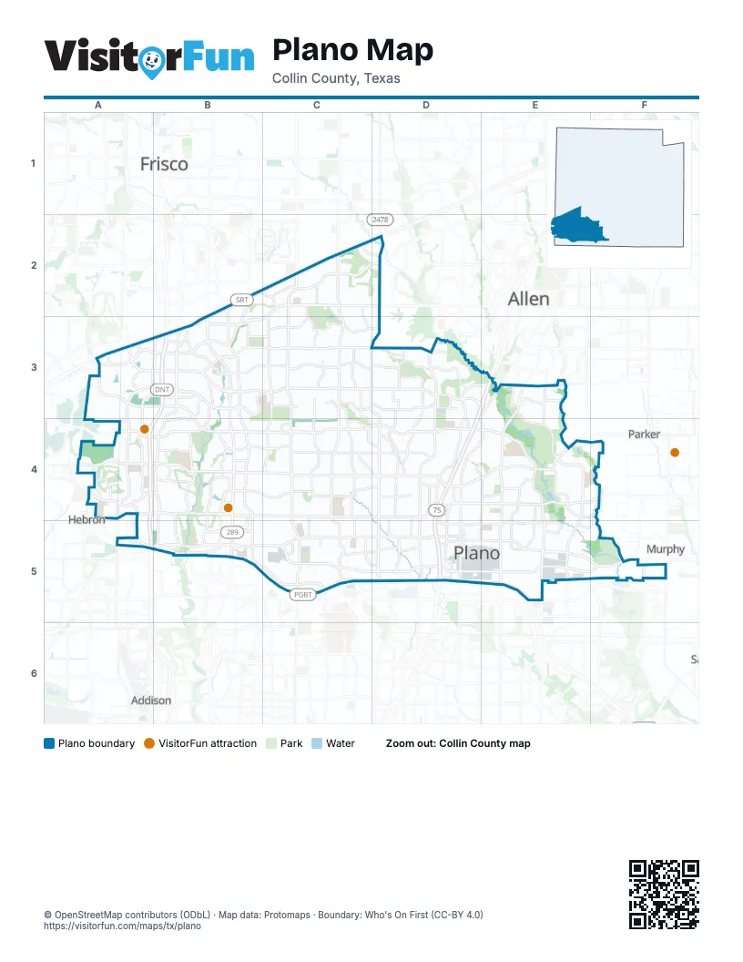
Street index of Plano
Each street on the sheet and the grid squares it crosses.
- Hillcrest RoadB2
- Ohio DriveB2, B3, B4, B5
- Rasor BoulevardB2, B3
- Sam Rayburn TollwayB2, C2, D2, B3
- State Highway 121B2, C2, D2, A3, B3
- Coit RoadC2, C3, C4, C5
- Cornerstone DriveC2, C3
- Gifford DriveC2, C3
- Gillespie DriveC2
- Independence ParkwayC2, C3, C4, C5
- Kathryn LaneC2, D2
- McDermott RoadC2, D2, B3, C3
- Preston Meadow DriveC2, C3, C4
- Ridgeview DriveC2, D2
- Rockledge LaneC2
- Custer RoadD2, C3, D3, D4, D5
- North Custer RoadD2
- South Custer RoadD2, D3
- Communications ParkwayA3, B3, A4
- Corporate DriveA3
- Headquarters DriveA3, B3
- Leadership DriveA3
- Legacy DriveA3, B3, C3, D3, E3
- McKamy TrailA3, A4
- Midway RoadA3, A4
- Tennyson ParkwayA3, B3
- West Spring Creek ParkwayA3, B3, B4, C4, D4
- Archgate DriveB3
- Dallas North TollwayB3, A4, B4, A5
- Dallas ParkwayB3, A4, B4, A5
- Democracy DriveB3
- Dominion ParkwayB3
- Granite ParkwayB3
- Hawkhurst DriveB3, C3
- Hedgcoxe RoadB3, C3, D3
- Parkshore DriveB3
- Parkwood BoulevardB3, B4, B5
- Pinecrest DriveB3, B4
- Pinehaven DriveB3, B4
- Preston Frontage RoadB3
- Preston RoadB3, B4, B5
- Quincy LaneB3, C3
- Robinson RoadB3
- Windcrest DriveB3, B4
- Bent Tree Springs DriveC3
- Breakers LaneC3
- Caravan DriveC3
- Cumberland TrailC3, D3
- Denham WayC3
- Hearst Castle WayC3
- Isabella DriveC3, D3
- La Guardia DriveC3
- Marchman WayC3
- Maumelle DriveC3
- Micarta DriveC3
- Mission Ridge RoadC3, C4
- Mount Vernon WayC3
- Old Orchard DriveC3, C4, D4
- Quarry Chase TrailC3
- Roundrock TrailC3, C4
- Russell Creek DriveC3
- Sailmaker LaneC3
- San Simeon WayC3
- Scenic DriveC3, D3
- Stonehaven DriveC3
- Sutherland LaneC3
- USA DriveC3, D3
- Alma DriveD3, D4, D5
- Baxter DriveD3
- Blue Ridge TrailD3, D4
- Central ExpresswayD3, E3, D4, D5
- Chase Oaks BoulevardD3, E3, D4
- Georgetown DriveD3
- Greenfield DriveD3
- McDonald LaneD3
- Mullins DriveD3
- Nottingham PlaceD3
- Oak Ridge DriveD3
- Prescott DriveD3
- Rainier RoadD3, D4
- Red River DriveD3
- Savage DriveD3
- Seabrook DriveD3
- Springfield DriveD3
- Stadium DriveD3
- Wesson DriveD3
- Wilderness TrailD3
- Bright Star WayE3
- Chaparral RoadE3
- Cloverhaven WayE3, E4
- Emerald Coast DriveE3
- Jupiter RoadE3, E4, E5
- K AvenueE3, D4, E4, D5
- Los Rios BoulevardE3, E4, E5
- Timber Brook DriveE3
- Chapel Hill BoulevardA4, B4
- Columbine WayA4
- La Costa DriveA4
- Marsh LaneA4
- Plano ParkwayA4, D5
- West Park BoulevardA4, B4, C4, D4
- West Parker RoadA4, B4, C4, D4
- West Plano ParkwayA4, A5, B5, C5, D5
- Windhaven ParkwayA4, B4
- Baywater DriveB4
- Bellaire DriveB4
- Charles PlaceB4
- Clark ParkwayB4
- Coventry LaneB4
- Highland DriveB4
- Lorimar DriveB4, C4
- Mira Vista BoulevardB4, B5
- Nassau DriveB4
- Preston Park BoulevardB4, B5
- Silver Creek DriveB4
- Tulane DriveB4, C4
- Ventura DriveB4, B5
- Willow Bend DriveB4
- Winding Hollow LaneB4, B5
- Yeary RoadB4
- Cross Bend RoadC4, D4
- Matterhorn DriveC4
- Parkhaven DriveC4, D4
- Pleasant Valley DriveC4, D4
- Silverstone DriveC4, D4
- Stonewood DriveC4
- Stratford DriveC4, C5
- Woodburn CornersC4, C5
- Archerwood StreetD4
- Baffin Bay DriveD4
- Central Parkway EastD4
- Chisholm PlaceD4
- Columbia PlaceD4, D5
- Country Place DriveD4
- East Park BoulevardD4, E4, F4
- East Parker RoadD4, E4
- East Spring Creek ParkwayD4, E4
- Enterprise DriveD4
- G AvenueD4, D5
- Lexington DriveD4
- P AvenueD4, E4, E5
- Pebble Vale DriveD4
- Premier DriveD4
- Republic DriveD4
- Rio Grande DriveD4, D5
- Wagner WayD4
- Laurel LaneE4
- Los Robles DriveE4, F4
- Ridgewood DriveE4, E5
- Rigsbee DriveE4, E5
- Royal Oaks DriveE4
- San Gabriel DriveE4
- Shiloh RoadE4, E5
- Country Club DriveF4, E5, F5
- Park BoulevardF4
- Horizon North ParkwayA5
- International ParkwayA5
- Mapleshade LaneB5, C5
- Meredith LaneB5
- Old Shepard PlaceB5
- President George Bush TurnpikeB5, C5, D5, E5
- Village Creek DriveB5
- Colchester DriveC5
- Commerce DriveC5
- Glencliff DriveC5, D5
- President George Bush HighwayC5, D5, E5
- West 15th StreetC5, D5
- Westlake DriveC5, D5
- Wilson DriveC5
- 13th StreetD5
- 13th/14th ConnectorD5
- 14th StreetD5, E5, F5
- 18th StreetD5, E5
- Alma RoadD5
- Carmel DriveD5
- Carmel PlaceD5
- Crawford RoadD5
- Custer ParkwayD5
- East 15th StreetD5
- East Plano ParkwayD5, E5, F5
- Executive DriveD5
- F AvenueD5
- Janwood DriveD5
- Municipal AvenueD5
- Westwood DriveD5
- North Jupiter RoadE5
- North Star RoadE5
- South Rigsbee DriveE5
- Timberline DriveE5
- Valencia DriveE5
- Brand RoadF5
Things to do on the Plano map
Places on the map
- 1201 Park Apartment Homes
- 12th Street
- Andrews Elementary School
- APEX
- Arbor Hills DORBA Trail
- Arbor Hills Nature Preserve
- Archgate Park
- Avignon Windhaven
- Bank of America Technology Center
- Barksdale Elementary School
- Barron Elementary School
- Baylor Scott & White Medical Center - Plano
- Baylor Scott & White The Heart Hospital - Plano
- Bel Air Oaks
- Bel Air on 16th Apartments
- Bell Gateway Village
- Bentley Place Apartments
- Berkeley Square
- Bethany Elementary School
- Big Lake
- Bluebonnet Trail
- Bluebonnet Trail Park
- Bob Woodruff Dog Park
- Bob Woodruff Park (North)
- Bob Woodruff Park (South)
- Bowman Middle School
- Broadstone Evoke
- Caddo Park
- Camden Legacy Park
- Carlisle Elementary School
- Carpenter Park
- Centennial Elementary School
- Cheyenne Park
- Children’s Medical Center Plano
- Chisholm Trail
- Christ United Methodist Church
- Christie Elementary School
- Clark High School
- Collin Creek Apartment Homes
- Collin Creek Redevelopment
Next to Plano
- Addison
- Allen
- Fairview
- Frisco map
- Hebron
- Murphy
- Parker
© OpenStreetMap contributors (ODbL) · Map data: Protomaps · Boundary: Who's On First (CC-BY 4.0)