

Texas map
Potter County map
About 114,649 people live here (Census Bureau, 2024 estimate). The sheet's index lists 300 streets; Purple Heart Trail, Tascosa Road and North US Highway 287 cross the most grid squares. Things to do inside the boundary: Cadillac Ranch, Don Harrington Discovery Center and The Big Texan Steak Ranch.
Open the map (PDF, US Letter)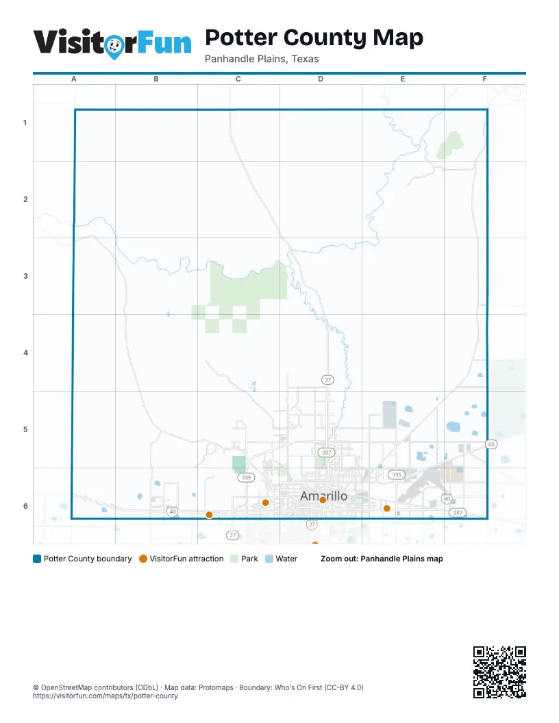
Maps inside Potter County
1 map inside, from the street map of Potter County down.
Street index of Potter County
Each street on the sheet and the grid squares it crosses.
- Purple Heart TrailA6, B6, C6, D6, E6, F6
- East Interstate DriveD6, E6
- Canyon ExpresswayD6
- East Interstate 40 Access RoadF6
- North US Highway 287C1, C2, D2, D3, D4
- West Amarillo BoulevardC6, D6
- East Amarillo BoulevardE5, F5, D6, E6
- Fritch HighwayF3, F4, E5, F5, E6
- East Saint Francis AvenueD5, E5, F5
- Dumas DriveD4, D5, D6
- North Lakeside DriveE5, E6
- US Highway 287C1, E6, F6
- Southwest 9th AvenueC6, D6
- North Soncy RoadC5, C6
- River RoadD5
- West Saint Francis AvenueD5
- South Soncy RoadC6
- Southwest 6th AvenueD6
- West Loop 335C6
- Southeast 10th AvenueD6, E6
- South Lakeside DriveE6
- Gravel Pit RoadC2, D2
- South Taylor StreetD6
- South Pierce StreetD6
- South Buchanan StreetD6
- Southeast 6th AvenueD6
- Tee Anchor BoulevardD6
- North Taylor StreetD6
- North Pierce StreetD6
- South Fillmore StreetD6
- North Buchanan StreetD6
- East Loop 335 NorthE5
- North Fillmore StreetD6
- Bushland BoulevardD6
- West Loop 335 SouthC6
- Walker BoulevardC6
- Loop 335C5
- US 287D6
- West TX-335 Loop NorthC5
- Tascosa RoadA2, A3, B3, B4, C5, C6
- West Interstate 40 Frontage RoadB6, C6
- Ranch Road 1061B4, B5, C5
- West Interstate DriveC6, D6
- North Western StreetD4, D5, D6
- Brickplant RoadC4, C5, D5
- Southeast 3rd AvenueD6, E6
- North Masterson RoadF4, F5, F6
- Broadway DriveD4, D5, D6
- North Eastern StreetE5, E6
- Martin Luther King Boulevard/NE 24th AvenueD6, E6
- East Willow Creek DriveD5, E5
- North Ranch Road 2381B5, B6
- North Grand StreetD5, D6
- Airport BoulevardE6, F6
- Folsom RoadE5, E6
- Wolflin AvenueC6, D6
- Cliffside RoadC5, D5
- Southwest 3rd AvenueD6
- Southeast 27th AvenueD6, E6
- Givens AvenueD4
- West Hastings AvenueD5
- West Cherry AvenueD5
- Hester RoadC5, D5
- South Georgia StreetD6
- South Masterson RoadF6
- North Mirror StreetD5, D6
- Southwest 8th AvenueD6
- South Western StreetD6
- Northeast 15th AvenueD6, E6, F6
- Southwest 10th AvenueD6
- South Pullman RoadE6
- North Whitaker RoadE5, E6
- Southwest 15th AvenueD6
- Crockett StreetD6
- East Hastings AvenueD5
- Northeast 3rd AvenueD6
- Plains BoulevardC6, D6
- Northwest 3rd AvenueD6
- Bell StreetC6
- Jackrabbit RoadF6
- Echo StreetD5, D6
- South Tyler StreetD6
- South Grand StreetD6
- Julian BoulevardD6
- South Bowie StreetD6
- South Harrison StreetD6
- South Eastern StreetE6
- South Travis StreetD6
- South Jackson StreetD6
- South Arthur StreetD6
- Line AvenueD6
- North Coulter StreetC5, C6
- North Hughes StreetD5, D6
- South Washington StreetD6
- Northwest 15th AvenueD6
- South Avondale StreetD6
- Triangle DriveE6
- Northeast 8th AvenueE6, F6
- FM 2575F6
- Southeast 28th AvenueD6, E6
- Southwest 28th AvenueD6
- East Cherry AvenueD5, E5
- South Coulter StreetC6
- Helium RoadC6
- South Blessen RoadB6
- 10th AvenueD6, E6
- Fairway DriveC6, D6
- Canyon DriveD6
- South Ranch Road 2381B6
- Smelter RoadD5, D6
- West Willow Creek DriveD5
- South Bolton StreetE6
- South Johnson StreetD6
- South Whitaker RoadE6
- Southeast 26th AvenueD6
- South Lincoln StreetD6
- South Manhattan StreetD6
- North Spring StreetD5, D6
- South Parsley RoadE6
- Olsen BoulevardD6
- South Osage StreetD6
- B AvenueE5, E6
- Ross StreetD6
- Southwest 26th AvenueD6
- Rio Grande StreetD6, E6
- Southeast 8th AvenueD6, E6
- San Jacinto AvenueD6
- Gem Lake RoadC6, D6
- Jim Line RoadB6
- Northeast 24th AvenueE6
- Farm-to-Market Road 1342F3
- North McMasters StreetD6
- Paramount BoulevardD6
- West Mobley StreetD5
- North Georgia StreetD5, D6
- East 16th AvenueD6, E6
- West Cliffside DriveD5
- Martin Luther King Boulevard/NW 24th AveD6
- Ridgemere BoulevardD6
- West 24th AvenueB6, D6
- Pecos StreetD6
- Southeast 11th AvenueD6, E6
- Nelson StreetD6
- Teckla BoulevardD6
- Juett Attebury RoadE6
- Hastings AvenueE5
- East Mobley StreetD5
- Wolflin Avenue/West Interstate DriveC6, D6
- South Adams StreetD6
- Gore Avenue/East Interstate DriveD6
- Ross Osage DriveD6
- South Bell StreetC6
- Industrial StreetD6, E6
- Southwest 24th AvenueD6
- Wimberly RoadD6
- DeVaughn Cortez ConnectorD6
- Elmwood DriveD6
- Melfrank DriveC5
- South McMasters StreetD6
- Southeast 15th AvenueD6
- Bushland RoadB6
- Coulter StreetC6
- Mirror-Echo ConnectorD5
- SE 10th AvenueD6
- Mockingbird LaneD6
- Ross Mirror ConnD6
- Quarter Horse DriveD6
- Ross Mirror ConnectorD6
- Hawthorne DriveD6
- Judd BoulevardC5
- Simmons RoadB6
- Spade DriveD6
- Southeast 20th AvenueD6
- Avenue BE5
- Ross-Mirror StreetD6
- East Cliffside DriveD5
- Soncy RoadC6
- Tower DriveD6
- NW 20th AvenueD6
- Pullman RoadE6
- West Interstate 40A6, B6, C6
- North Parsley RoadE5
- Indian Hill RoadB6, C6
- Cas Johnson RoadE2, F2
- Northeast 20th AvenueD6, E6, F6
- Northeast 16th AvenueD6, E6
- Wallace BoulevardC6
- F AvenueF5, E6, F6
- McBride Canyon RoadE2
- Estates DriveB5, C5, B6
- Northeast 13th AvenueD6, E6, F6
- Northeast 11th AvenueD6, E6, F6
- Southwest 1st AvenueC6, D6
- Alibates RoadE1, E2
- Southeast 29th AvenueD6, E6
- Northwest 4th AvenueD6
- East 14th AvenueD6, E6
- Northwest 2nd AvenueD6
- North Dowell RoadC6
- Hope RoadC6
- Northwest 1st AvenueD6
- Northwest 10th AvenueD6
- Northwest 5th AvenueD6
- Arlie RoadD4, D5
- South Lipscomb StreetD6
- South Polk StreetD6
- South Hayden StreetD6
- Hill DriveB6
- Southwest 11th AvenueC6, D6
- South Van Buren StreetD6
- Northwest 12th AvenueD6
- Southwest 16th AvenueD6
- Northeast 10th AvenueD6, E6
- East Central AvenueD5
- Angelus DriveD5, D6
- South Austin StreetD6
- Northwest 11th AvenueD6
- Durrett DriveC5
- East 12th AvenueD6, E6
- Ramada TrailD5
- Southeast 9th AvenueD6
- Southwest 7th AvenueD6
- Adkisson RoadA6
- North Polk StreetD6
- Southeast 22nd AvenueD6
- Martin RoadD6
- East 15th AvenueD6, E6
- Westwood DriveC6
- West County Line RoadA6
- Stone Creek RoadB6
- North Jefferson StreetD6
- Plum Creek DriveC6
- Southwest 21st AvenueC6, D6
- Centerport BoulevardE6
- Oak DriveD5, D6
- South Virginia StreetD6
- North Washington StreetD6
- Sharman LoopC5
- J AvenueF5, F6
- Southwest 5th AvenueD6
- Northeast 5th AvenueD6
- Pavillard DriveD5
- North Seminole StreetD5, D6
- Southwest 22nd AvenueD6
- Southeast 21st AvenueD6
- North Highland StreetD5, D6
- North Tyler StreetD6
- North Osage StreetD5, D6
- Westgate Parkway WestC6
- North Rusk StreetD6
- Northeast 4th AvenueD6
- Northeast 7th AvenueD6
- East 8th AvenueD6, E6
- Lawrence BoulevardC6, D6
- Quail BoulevardC5, D5
- Sierra Hills RoadC5, D5
- Northeast 27th AvenueD5, E5, F5
- South Seminole StreetD6
- Point West ParkwayC6
- South Dowell RoadC6
- Stonebridge Gate RoadC5
- Southeast 17th AvenueD6, E6
- West Yucca AvenueC5, D5
- Southeast 19th AvenueD6
- North Grant StreetD6
- North Vernon StreetD5, D6
- Bezner DriveB6
- North Lake StreetD5, D6
- Erik AvenueC6, D6
- Southeast 24th AvenueD6
- Bridlewood DriveC6
- Sunset TerraceD6
- Heather StreetE6
- South Spring StreetD6
- Patrick PassC5
- West Line RoadA6
- Glenn StreetD5
- Leroy WayD5
- Denton StreetE5
- Southeast 16th AvenueD6
- North Ong StreetD6
- West Central AvenueD5
- South Grant StreetD6
- North Blessen RoadB6
- South Dallas StreetD6
- West 15th AvenueC6, D6
- Northeast 21st AvenueD6, E6, F6
- Northwest 18th AvenueD6
- Westcliff ParkwayC6
- Southeast 1st AvenueD6, E6
- Poplar StreetD5, D6
- Jason AvenueD5
- North Lincoln StreetD6
- Woodside DriveC5, C6
- North Travis StreetD6
- North Fannin StreetD6
- North Lamar StreetD6
- Evergreen StreetE6
- Buck StreetD5
- South Philadelphia StreetD6
Things to do on the Potter County map
Places on the map
- Alibates Flint Quarries National Monument
- Amarilllo Pullman Yard
- Amarillo
- Amarillo City Landfill
- Amarillo College East Campus
- Amarillo Country Club
- Amarillo Fairgrounds Complex
- Amarillo Lake
- Amarillo North Yard
- Amarillo Shooting Complex
- Amarillo South Yard
- Amarillo Speedbowl
- Amarillo Stockyards
- Amarillo Terminal Reservoir
- Amarillo Tri-State Fairgrounds
- Anfiteatro de La Hacienda Event Center
- Big Texan RV Ranch
- Bishop Hills
- Bonita Sand & Gravel
- Buc-ee's
- Bushl
- Bushland High School
- Cadillac Ranch
- Caliche Pits
- Canadian River
- Chicago, Rock Island and Pacific Railroad
- Cross Bar Special Recreation Management Area
- DC Caliche Materials
- Howell Sand & Equipment
- Julian Blvd Park
- Lake Meredith National Recreation Area
- McGee Lake
- Rick Husband Amarillo International Airport
- Ross Rogers Public Golf Course
- San Carlos Event Center
- Sears Park Addition
- Stalanaker Lake
- T-Anchor Lake
- Thompson Park
- Wildcat Bluff Nature Center
© OpenStreetMap contributors, Open Database License, openstreetmap.org/copyright · Map data: Protomaps · Boundary: Who's On First (CC-BY 4.0); Quattroshapes (CC BY 2.0)