

Texas map
Panhandle Plains map
The sheet's index lists 48 highways; US 87, US 287 and US 83 cross the most grid squares. Things to do inside the boundary: Abilene Cultural District, American Windmill Museum and Bill's Backyard Classics. Also on it: Abilene, Amarillo and Andrews.
Open the map (PDF, US Letter)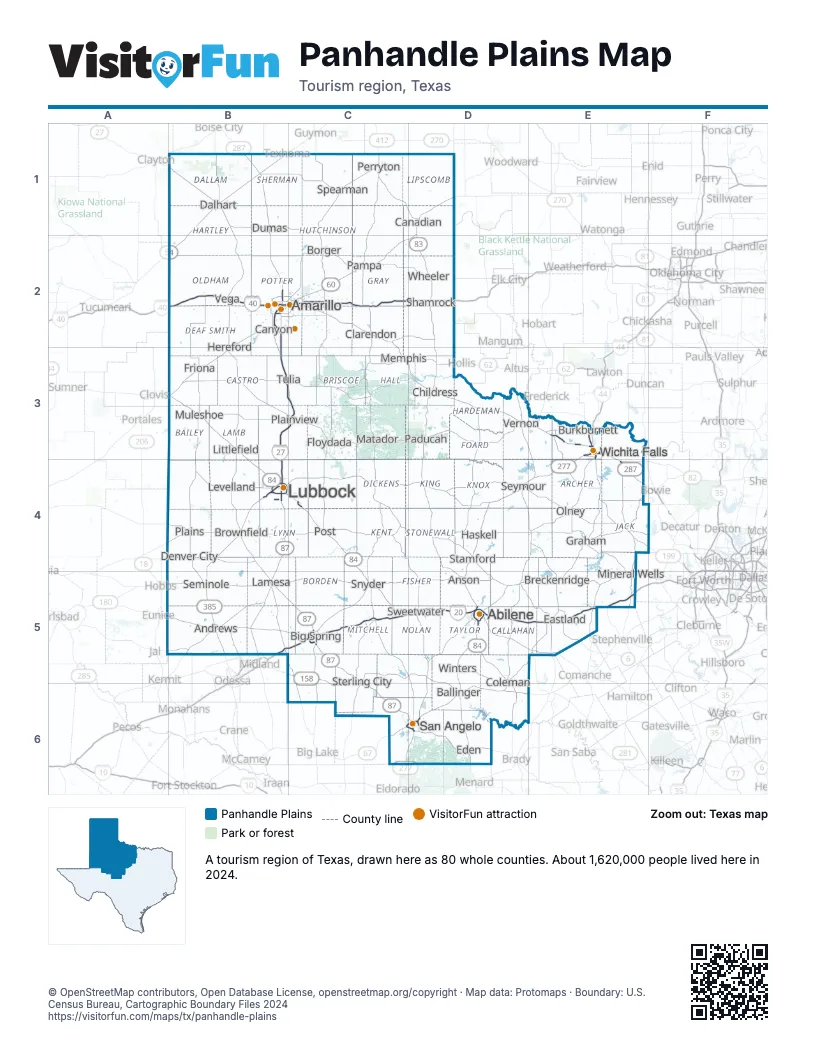
Highway index of Panhandle Plains
Each highway on the sheet and the grid squares it crosses.
- I-20B5, C5, D5, E5
- I-27B2, B3, B4, C3
- I-40B2, C2, D2
- I-44E3
- US 54B1, B2
- US 60B2, B3, C2, D1, D2
- US 62A5, B4, B5, C4, D3
- US 66B2
- US 67C6, D6
- US 70B3, D3, E3
- US 82B4, C4, D4, E3, E4
- US 83C1, D1, D2, D3, D5, D6
- US 84B3, B4, C4, C5, D5, D6
- US 87B1, B2, B3, B4, B5, C3, C5, C6, D6
- US 180A5, B5
- US 183D3, D4, E3, E4
- US 277C6, D4, D5, D6, E3, E4
- US 281E3, E4
- US 283D4, D5, D6, E4
- US 287B1, B2, C2, C3, D3, E3, E4
- US 380E4, F4
- US 385B1, B4, B5
- TX 6E5
- HR 66C2
- TX 70C2, D5
- TX 79E3
- TX 114B4, C4, D4, E4, F4
- TX 152C2
- TX 158C5, C6
- TX 163C5
- FM 168B2, B4
- FM 179B4
- TX 199E4
- TX 203D2
- TX 206D5
- TX 208C5
- TX 214B3
- FM 303B4
- TX 349B5
- FM 369E3
- FM 378C4
- FM 789C4
- FM 829B5
- FM 925D3
- FM 1033D3
- FM 1151C2
- FM 1585B4
- FM 2943B2
Things to do on the Panhandle Plains map
- Abilene Cultural District
- American Windmill Museum
- Bill's Backyard Classics
- Buddy Holly Center
- Buffalo Gap Historic Village
- Cadillac Ranch
- Caprock Canyons State Park and Trailway
- Don Harrington Discovery Center
- Eastland County Museum
- Fort Griffin State Historic Site
- Frontier Texas
- Heritage Museum of Big Spring
- Museum at Texas Tech University
- Palo Duro Canyon State Park
- Palo Pinto Mountains State Park
- Panhandle–Plains Historical Museum
- Red River Valley
- River Bend Nature Center
- San Angelo Visitor Center
- South Plains Mall
- The Big Texan Steak Ranch
Places on the map
- Abilene
- Amarillo
- Andrews
- Anson
- Ballinger
- Big Spring
- Borger
- Breckenridge
- Brownfield
- Burkburnett
- Canadian
- Canyon
- Childress
- Clarendon
- Coleman
- Dalhart
- Denver City
- Dumas
- Eastland
- Eden
- Floydada
- Friona
- Graham
- Haskell
- Hereford
- Lamesa
- Levelland
- Littlefield
- Lubbock
- Matador
- Memphis
- Mineral Wells
- Muleshoe
- Olney
- Paducah
- Pampa
- Perryton
- Plains
- Plainview
- Post
- San Angelo
- Seminole
- Seymour
- Shamrock
- Snyder
- Spearman
- Stamford
- Sterling City
- Sweetwater
- Tulia
- Vega
- Vernon
- Wheeler
- Wichita Falls
- Winters
Next to Panhandle Plains
- Northeast New Mexico
- Southeast New Mexico
- Great Plains Country
- Red Carpet Country
- Big Bend Country map
- Hill Country map
- Prairies and Lakes map
© OpenStreetMap contributors, Open Database License, openstreetmap.org/copyright · Map data: Protomaps · Boundary: U.S. Census Bureau, Cartographic Boundary Files 2024